
3
Recharge Through The Unsaturated Zone
Issue 11 Potential Transfer of Contaminants Through The Unsaturated Zone To The Ground Water
THE WILSHIRE GROUP POSITION
The Wilshire group questioned the adequacy of the evaluation in the license application and supporting documents of the nature of water movement in the thick unsaturated zone beneath the Ward Valley site (Wilshire et al, 1993a, 1993b). They divided this issue into five subissues. These are:
-
The soil properties measured and used in the modeling of water movement in the unsaturated zone do not adequately represent the variability and complexity of the materials present.
-
No consideration was given to rapid migration of water along preferential pathways.
-
The reporting of tritium at depths of up to 30 m indicates vertical water transport at rates much faster than that used in the performance-assessment models.
-
Electrical sounding data from along Homer Wash suggest the possible existence of higher water content that may indicate ground-water recharge from the wash.
-
Interpretation of both stable and radioactive tracers found in the ground water in the license application was incorrect and could be interpreted as evidence of recent recharge through the unsaturated zone.
THE DHS/U.S. ECOLOGY POSITION
The DHS concluded that, based on the general aridity of the site, hydraulic data collected from boreholes, the interpreted age of the ground water, and a simplified tritium diffusion model, the site shows no evidence for high water flux or rapid pathways.
THE COMMITTEE'S APPROACH
The committee grouped the subissues raised by Wilshire et al. (1993b) into three broad questions relevant to the behavior of water in the unsaturated zone:
-
What is the nature, direction, and magnitude of soil-water movement beneath the Ward Valley site, including the influence of geologic heterogeneity and the relative importance of piston and preferential flow (Wilshire et al., 1993a, b; subissues 2, 3, and 4)?
-
Are the data and models used to quantify the rate and direction of water and contaminant movement through the unsaturated zone adequate to define the general performance characteristics (Wilshire et al., 1993b, subissue 1)?
-
Does ground water below the Ward Valley site show evidence of recent recharge (Wilshire et al., 1993a, b; subissue 5)?
In (1), the discussion of the broad issue of soil-water movement will address the three subissues. For each of these questions, the committee has looked closely at the data available from both the site license and supporting documents, at the relevant scientific literature, as well as at documents supplied by interested individuals and organizations at the open meetings and subsequently.
To answer each of these questions, a brief review of the nature of soil-water movement and its implications for waste disposal will put the issues in perspective. Data from previous studies of water movement in the unsaturated zone with emphasis on add regions are instructive. These previous studies show that the science of unsaturated-zone hydrology is young and that the techniques employed continue to have significant uncertainties. As a result, the committee considered it prudent to base its conclusions on the results of multiple and independent lines of evidence, not only of the most likely estimate of water velocity, but also to assess the performance impacts of other, less likely, estimates.
THE NATURE OF WATER MOVEMENT IN THE UNSATURATED ZONE
In a typical add setting, most precipitation infiltrates the soil, except under conditions of intense precipitation. Some of this water evaporates and some is transpired by plants. Together these two processes, which return rain water to the atmosphere, are termed evapotranspiration. If the volume infiltrated is greater than that evapotranspired, it can result in deep downward or lateral percolation. If the unsaturated zone is thin or the percolation rate high, the recharge rate at the water table will approach the rate of percolation over a long time. If, however, the unsaturated zone is very' deep and the percolation rate is small, then the recharge rate may be out of time-phase with the current near-surface conditions. In such cases, it is important to differentiate between measurements of deep percolation in the unsaturated zone and estimates of recharge made at the water table.
Water Content
Water content is a standard soil physics parameter useful for evaluating water movement in the unsaturated zone is water content. Water content is either measured in the laboratory using soil samples collected in the field or monitored in the field using a neutron probe or time-domain reflectometry to determine the soil dryness.
Water-content monitoring can be used to evaluate the movement of water pulses through the unsaturated zone. In general, errors associated with the typical water-content measurement techniques (neutron probe or time-domain reflectometry) are generally ±1 percent volumetric water content. This may not be sufficiently accurate to detect small fluxes that could move through the deep unsaturated zone of desert soils. Under conditions of steady flow, water content will not vary; therefore, the absence of temporal variations in water content does not necessarily preclude downward flow. In such a case, the flow is controlled by the hydraulic conductivity of the soil. Water-content monitoring is most applicable for measuring large subsurface water fluxes under transient conditions. In addition, water content is discontinuous across different soil types; therefore, variations in water content with depth in heterogeneous soils do not necessarily indicate the direction of water movement.
Water content data are available for many sites from interstream settings and show that water contents in desert soils are generally low. Long-term monitoring of soil water has been used to evaluate infiltration and deep percolation in several arid sites. Some of these studies were carded out at a site in the Chihuahuan Desert of New Mexico. Rainfall at the New Mexico site is approximately twice that at Ward Valley. The seasonal distribution of rainfall at the New Mexico site also differs from that at Ward Valley, with more summer precipitation at the New Mexico site, which is typical of the Chihuahuan Desert, and more winter precipitation at the Ward Valley site, typical of the Mojave Desert. Winter precipitation is more effective at infiltrating the soil than summer precipitation because of lower evapotranspiration in the winter. Long term precipitation records (1953-1989) at the Jornada Experiment Range in New Mexico indicate that only 23 percent of the rain falls between November and March whereas 50 percent of the rain falls between November and March in Needles, California (period of record 1948 to 1989). Although the seasonal distribution of rainfall differs between the two sites, the amount of winter rainfall is similar (5.6 cm Needles; 5.9 cm Jornada Experiment Station); therefore, results of studies at the New Mexico site are applicable to the Ward Valley rite.
Long-term studies in the Chihuahuan Desert measured soil moisture along a transect from an ephemeral lake through the piedmont and up a steep rock slope (Wierenga et al., 1987). Large spatial variability in water content was recorded from a mean of 0.3 m3/m3 (± 0.04 m3/m 3) at 130 cm depth in the playa to 0.04 m3/m3 (± 0.04 m3/m3) at the upper rocky end of the transect (Figure 3.1). This variability reflects in part the textural variations from the clayey soils in the playa to more gravelly soils at the rocky slope. Temporal variations in water content were measured for a site near the center of the transect. This site is located on an alluvial fan with a deep loamy soil and is vegetated with creosote bush similar
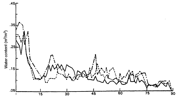
Figure 3.1 Variation in water content on an alluvial fan along a 3 km transect in the Jornada Range in southern New Mexico. Water contents presented for depths of 30, 90, 130 cm during the week of 30 April - 6 May 1992. Symbols: ——, 30 cm;-- -- -,90 cm; -•- 130 cm. Vegetation is creosote bush and annual rainfall is 20 cm.
to the Ward Valley site. Although the soils at the Las Cruces site in New Mexico and at Ward Valley are similar in terms of their soil hydraulic properties, we recognize that the ecological systems at the two sites are different.
The data at the Las Cruces site display significant variations in water content at 30 cm depth during six of the nine years studied. At a depth of 130 cm, fluctuations in water content occurred only in response to the relatively wet fall and winter of 1985. Thus during eight of the nine years, rainfall that infiltrated the soil was taken up by the plant roots in the upper 130 cm of the root zone and evapotranspired back into the atmosphere. Plant roots were observed in a 6 m deep trench near the trench down to 4 m depth. Most likely, water that passed the 130 cm depth was taken up by plant roots below that, as observed during one of the nine years studied.
Water-content monitoring at the Beatty site from 1978 to 1980 measured infiltration and redistribution of water down to approximately 2-m depth in 1979 to 1980 (Nichols, 1987). The deep penetration of water was attributed to high precipitation in 1978 (23.35 cm
at the site, twice the long-term average) and precipitation in January 1979 (4.62 cm) followed by additional rainfall in March 1979 (2.52 cm). This emphasizes the importance of antecedent water content in the soil and the sequence of precipitation events in controlling percolation. Monitoring at Beatty from 1984 to 1988 showed water movement, was restricted to the upper one meter during this period (Fischer, 1992).
Water content was monitored in a small scale ephemeral stream setting (maximum topographic relief of 0.65 m) in the Hueco Bolson of Texas (Scanlon, 1994a). Approximately monthly monitoring of water content from July 1988 to October 1990 showed that within the detection limit of the neutron probe (± 0.01 m3/m3) water content remained constant from 0.3 to 41 m depth. Although precipitation during 1989 was 50 percent of the long term mean annual precipitation, precipitation during 1990 was similar to the long term mean. Data from these desert basins indicate that penetration of water is often restricted to the shallow subsurface. The reason for the shallow penetration of water in desert soils is the large storage capacity of the surficial sediments. For example, soils similar to those at Ward Valley with an initial average volumetric soil-water content of 10 percent and a water content at saturation of 35 percent have a maximum additional storage capacity of 25 percent by volume, which is equivalent to 25 cm of water storage per meter of soil profile. To bring this into perspective, if an annual rainfall of 12.7 cm could fall in one day, the 12.7 cm of water could hypothetically be stored in only 50.8 cm of soil. In reality, the soil would not come to full saturation, but water would move deeper into the soil profile. Even if the soil-water content were to increase to 17.5 percent (which is 50 percent of saturation), the 12.7 cm annual precipitation would wet the soil down to only 170 cm. This demonstrates the great storage capacity of dry desert soils in general and of Ward Valley in particular.
Potential Energy of Soil Water
In contrast to water content, water potential energy is continuous across different soil types and is typically used to infer the flow direction. Water flows from regions of higher total potential energy to regions of lower total potential energy. In areas with moderate to high subsurface water flux, gravity and matric potential are the dominant driving forces. Matric forces result from the interactions of the water and the soil matrix and include capillary and adsorptive forces. An example of such behavior is demonstrated when a sponge is placed in water. Water can move upward, against gravity, into the sponge until some equilibrium is reached.
Matric potential is expressed in meters of water, bars or megapascals (MPa). For comparison, 1 Mpa = 10 bars = 102 m of water. Because water is tightly held by unsaturated soil, the matric potential has a negative value. If soil becomes wetter, its matric potential becomes less negative until at saturation it becomes zero. Matric potential is related to soil-water content through the soil water retention curve.
Hydraulic Conductivity
The rate of water flow q through soil is proportional to its hydraulic gradient dH/dz with the proportionality constant being the hydraulic conductivity, K. This is expressed through Darcy's law:
where H is the hydraulic head, equal to the sum of the matric potential head and the gravitational potential head, and z is the vertical space coordinate taken as positive upward (see Box 3.1).
|
BOX 3.1 DRIVING FORCES FOR FLOW IN THE UNSATURATED ZONE The soil-water potential energy is typically used to infer the water flow direction because water will flow from regions of high to low potential. In the unsaturated zone, many gradients may be important, as is indicated by the generalized flux law (modified from de Marsily [1986]): where q is the flux, L1, L2, and L3 are proportionality constants, Δ is the gradient operator, H is the hydraulic head (sum of matric and gravitational potential heads), T is the temperature and C is the solute concentration. This equation holds for systems in which water flow occurs in liquid and vapor phases. The direction of liquid flux is controlled by gradients in hydraulic head whereas the direction of isothermal and thermal vapor flux is controlled by hydraulic head and temperature gradients, respectively. In some flow systems, temperature and osmotic potential gradients are negligible and the flux can be simplified to the Buckingham-Darcy law (the first term to the right of the equal sign in the above equation, the means of calculating downward liquid flow). To quantify the water flux, information on the proportionality constants is also required. Under isothermal conditions, which implies absence of a thermal gradient, and when liquid flow dominates, the relationship between hydranlic conductivity and water content or matric potential is used to calculate the flux. Hydraulic conductivity decreases exponentially with decreased water content or matric potential. In arid systems, where the matric potential gradient is large, the reduction in hydraulic conductivity with decreased matric potential will outweigh the effect of the increased gradient and will result in negligible flow. In cases where vapor flux is important, isothermal and thermal vapor diffusivities should be measured or estimated to quantify vapor flux. |
The ability of unsaturated soil to conduct water, i.e. the hydraulic conductivity, is directly related to its water content. At saturation, soils have their highest hydraulic conductivity. As a soil dries, the larger pores empty first, causing the hydraulic conductivity to decrease. In fact, the hydraulic conductivity of many soils decreases exponentially with decreasing water content or soil-water potential (Gardner, 1958). Thus a decrease in water content by only a few percent can produce a 10-fold or a 100-fold decrease in hydraulic conductivity. Therefore, the very low water contents found in the subsoils of vegetated areas at interstream positions of warm deserts suggest very low hydraulic conductivities and low recharge rates.
In typical interstream settings in add regions where the soils are extremely dry and water fluxes are low, much of the water movement may occur in the vapor phase. Because the fluxes are so small, the direction and magnitude of the fluxes may be difficult to determine. In addition to liquid flow, as a result of matric and gravitational potential gradients, vapor flow induced by temperature gradients may also be important.
Potential Energy of Soil Water
Darcy's law also requires a knowledge of the gradient in potential energy, dH/dz. Instruments used to measure potential gradients include tensiometers and heat dissipation probes (HDP's), which measure matric potential, and thermocouple psychrometers, which measure temperature and water potential (sum of matric and osmotic potential). Osmotic potentials can be calculated from soil-water chloride concentration data (Campbell, 1985) and can be subtracted from water potential to estimate matric potential.
Except in the shallow subsurface after rainfall, levels of water potential measured in add and semiarid regions generally decrease toward the surface. This suggests an upward driving force for liquid and isothermal vapor flux (Fischer, 1992; Estrella et al., 1993; Scanlon, 1994). The osmotic component of water potentials, which refers to the energy required to remove dissolved salts from the water, is generally low at depth at these sites because chloride concentrations below the top 10 m are generally low (Phillips, 1994).
Long-term monitoring records of soil-water potentials and water contents for add sites are limited. Monitoring data from the Beatty site displayed increased water potentials between depths of 1 to 2 m after precipitation in November 1987 (Nichols, 1987). Neutron moisture probe readings for the same period of record did not show changes in water content, probably because the changes in water content were within the standard error of the neutron probe readings. In the Chihuahuan Desert of Texas, at a silty loam site within a small-scale ephemeral stream setting, water potentials measured from summer 1989 to summer 1990 were out of range (<-8.0 MPa) of the thermocouple psychrometers in the upper 0.8 m, because the sediments were too dry (Scanlon, 1994). Water potential monitoring has continued since that time to 1995 and has shown that the wetting front has not penetrated below the upper 0.3 m at this site. In general, below the shallow zone of active circulation, matric potentials show seasonal fluctuations in response to seasonal temperature fluctuations
down to depths of 12 m (Fischer, 1992; Scanlon, 1994). Below the zone of seasonal fluctuations, water potentials remain constant over time.
One can also estimate the matric potential that would exist in the unsaturated zone if it were in hydraulic equilibrium with the water table. Under equilibrium conditions, the total soil-water potential energy is everywhere constant. (In the sponge example discussed previously, the capillary forces drawing the water upward are in balance with the force of gravity tending to pull the water downward). Under these conditions, the soil matric potential energy is at equilibrium with gravitational forces. If z (the vertical space coordinate) is taken as positive upward and zero at the water table, then under these conditions the equilibrium soil matric potential can be described by a line starting at zero at the water table and equal to the negative of the height above the water table (Figure 3.2). Under steady flow conditions, matric potentials displaced to the fight of the equilibrium line indicate downward flow, whereas those plotted to the left indicate upward flow (Figure 3.2). At several arid western sites (Fischer, 1992; Estrella et al., 1993; Scanlon, 1994) matric potentials plot to the left of the equilibrium line indicating upward driving forces for liquid and isothermal vapor movement (Estrella et al., 1993; Scanlon, 1994). At the Nevada Test Site (NTS) this upward driving force is restricted to the upper 40 m. Below this depth, water potentials plot to the right of the equilibrium line, which suggests that water in this portion of the profile may be moving downward to the water table (Sully et al., 1994).
Below the zone of seasonal temperature fluctuations, the upward geothermal gradient provides an additional upward driving force for thermal vapor movement. This is approximately 0.06°C/m at the Beatty site (Prudic, 1994a). Sully et al. (1994) suggest that this upward thermal vapor flux may be of the same order of magnitude as the downward liquid flux at depth at the NTS; such a condition would result in no net flux of water but a slow downward migration of water-soluble chemicals.
Vegetation also plays a critical role in removing water from desert soils. Lysimeter data from Hanford and Las Cruces showed that deep percolation from bare sandy soils can range from 10 to >50 percent of the annual precipitation (Gee et al., 1994). Therefore, the use of data developed on undisturbed sites in Ward Valley to predict long-term performance through the operation and closure period is acceptable only if the conditions include reestablishment of the active plant communities after the waste is emplaced. There remains uncertainty of the effects of trench construction on the long-term water balance at any disposal site, and the goal of the closure and trench cover program outlined in the license application is to reduce these uncertainties.
Nature of Water Movement: Piston Flow And Preferential Flow
In general, two types of water movement occur in unsaturated zones, piston flow and preferential flow. Piston flow refers to uniform water movement downward through the soil matrix. Infiltrated water displaces initial water. In contrast, preferential flow refers to nonuniform downward water movement along preferred pathways, such as continuous vertical fractures, or pathways created by changes in soil characteristics.
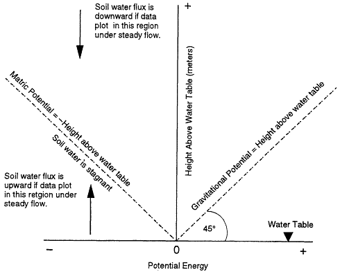
Figure 3.2 The relationship of the equilibrium matric potential to height above the water table. If the soil water is stagnant, the matric potential is exactly balanced by the gravitational potential represented by the height above the water table. A simple measure of the direction of flow can be made by plotting matric potential head (calculated from field measured water potentials by subtracting the osmotic potential) versus the height above the water table.
A variety of factors are important in preferential flow, including continuity of preferred pathways and exposure of the pathways to ponded or perched water (Beven, 1991). Because water will enter fractures (even microfissures and relatively small vertical cracks) only when soils approach saturation, preferential flow has been documented mostly in more humid regions with higher rainfall. The Ward Valley alluvium consists of variable mixtures of poorly sorted sand, silt, gravel, and clay, with greater variability vertically than horizontally, as discussed later in this chapter. Thus the most significant pathways are likely to be along root tubules, cracks, and fracture planes (including faults). Although some have considered flow associated with major hydrologic features such as ephemeral streams and playas as preferential flow (Gee and Hillel, 1988), we will restrict our discussion to the kinds of pathways described above.
In uniform soils and at low rates of soil-water movement, water will generally flow in a piston-like manner, particularly if the soils are dry initially. Under piston-like flow
conditions most, if not all, preexisting water (''old'' water) is displaced and moved ahead of the "new" infiltration water added from above. Under certain conditions, only a fraction of the "old" water is displaced and water moves through preferential pathways. Preferential flow is the process whereby water and solutes move along preferential pathways through a porous medium (Helling and Gish, 1991). During preferential flow, local wetting fronts may propagate to considerable depths in a soil profile, essentially by passing the matrix pore space. (Bevin, 1991; Steenhuis et al., 1994). Preferential flow has been demonstrated under laboratory conditions (Glass et al., 1991) and under simulated rainfall conditions (28-152 cm/day) in forested field soils (Turton et al., 1995). However, in dry desert soils, water that is moving through preferential pathways, such as roots and root tubules, is expected to be absorbed by the dry soil around the pathways. Also, layering caused by differences in texture will disrupt the continuity in the flow paths. Therefore preferential flow is expected to be damped out over a relatively short distance below the root zone.
The rate and depth of infiltration along preferential pathways is often greater below areas of surface ponding or frequent flooding than below higher ground.
Piston flow is generally found in add sites where sediments are not subjected to intermittent or continuous ponding. At study sites in both southern New Mexico and southern Nevada, where long-term monitoring of soil-water content has been conducted, measurements have confirmed that significant changes in water content are restricted to the upper 1-2 m. The water input to these systems that receive water only from precipitation may be too low to result in preferential flow. In addition, much of the water in these dry soils is adsorbed on the grain surfaces and therefore cannot move along preferred pathways,
Piston flow is also indicated by single peaks on profiles of the chemical tracer, chlorine-36 (36Cl), as in the profile measured in a small-scale ephemeral stream setting in the Hueco Bolson in Texas (Scanlon, 1992a). The single 36Cl peak suggests that the bomb related 36Cl which fell on the land surface in the mid 1960's has moved downward uniformly and retains its bell-shaped profile. If non-piston flow had occurred, the 36Cl in the soil zone would show a much more erratic pattern, with alternating highs and lows corresponding to zones of fast and slow water movement. Large-scale infiltration experiments conducted at Las Cruces showed that the movement of dissolved solids, or solutes, lagged behind the water, or wetting front (Young et al., 1992). The lag between the solutes and wetting fronts increased with depth, which indicated piston displacement of initial soil water, rather than preferential flow. The lag also increased with increased initial water content.
Previous studies specifically identifying preferential flow in alluvial deposits in desert regions are limited. Allison and Hughes (1983), in a study of recharge in south central Australia, observed tritium much deeper (12 m) in the soil profile than was predicted from other tracers and the general aridity of the region. They attributed the tritium transport to flow along channels occupied by living roots. No data on tritium transport below the root zone were presented (Allison and Hughes, 1983). Shrubs at Ward Valley, such as creosote bush have much shallower roofing depths (< 1-2 m) than the eucalyptus plants reported by Allison and Hughes (1983). Fracture flow has also been reported at Yucca Mountain, Nevada by Yang (1992) and Fabryka-Martin et al. (1993); however, the geologic setting at Yucca
Mountain differs greatly from that at Ward Valley, as the Yucca Mountain unsaturated zone is in faulted and fractured volcanic rock.
Preferential flow has also been found in fissured sediments in the Chihuahuan Desert of Texas (Baumgardner and Scanlon, 1992; Scanlon, 1992a). They conducted detailed studies of fissured sediments in the Hueco Bolson in Texas. These features consist of an alignment of discontinuous surface gullies (<140 m long) underlain by sediment-filled fractures (2 to 6 cm wide) that extend to a depth of >6 m. Similar features have not been found at Ward Valley.
Fractures were observed in the Quaternary alluvium at the site and are prominently exposed in the old I-40 borrow pit. These could be either desiccation or tectonic fractures. Their nature and continuity at depth are unclear, but unless a systematic investigation is made of these fractures, it is not possible to assess their origin or continuity. The impact of fractures on fluid flow can be deduced from the distribution of water content and tracers found in the unsaturated zone.
In summary, studies have shown that water movement in arid soils is controlled by several factors, such as energy gradients, topography, and the complexity of the soil materials. It is therefore critical that comprehensive and detailed studies be performed at any site where the unsaturated zone is to be used as a primary barrier for waste isolation. In the next sections, the data for the Ward Valley site are reviewed with respect to this criterion.
THE NATURE, DIRECTION, AND MAGNITUDE OF WATER FLUX BENEATH THE WARD VALLEY SITE
The Wilshire group (Wilshire, 1993a, b, and 1994) questioned the assertion in the license application that percolation is negligible beneath the site. They based this on observations of preferential flow in other areas and on the reported tritium concentrations found at depths to 30 m below the surface. They also raised the question of the potential for recharge in Homer Wash and its implication for site performance.
The techniques commonly used to estimate soil-water flux in the unsaturated zone fall into two broad categories: soil physics methods and chemical tracer techniques.
Soil Physics Methods Applied To Ward Valley
The two types of soil physics methods used to compute deep percolation at the Ward Valley site are: water-content monitoring and hydraulic gradients.
Water-Content Data
Water contents measured from the surface to 27 m depth in 82 soil samples collected from six borings (GB-1 through GB-6, LA Appendix 2420.B) were generally very low. Twenty samples had volumetric water contents less than 5 percent, 57 samples had water contents between 5 and 10 percent, and 5 samples had water contents between 10 and 15 percent. The higher water contents were in the clayey sands. These data suggest that the sediments are extremely dry.
Soil-water content monitoring at the Ward Valley site was very limited.Neutron-probe logging of the water content was conducted under ambient conditions in only one access tube to a depth of 6 m. A pneumatic drilling system (ODEX) was used to install the access tube and consisted of drilling a 15-cm diameter borehole and installing a 5-cm diameter aluminum access tube. Native sediments were used to backfill the annular space surrounding the access tube. A baseline log obtained on October 5, 1990 serves as a standard to compare to later logging. One standard deviation of the count rate difference between the baseline and observed neutron logs was approximately 95 counts per second, which corresponds to an uncertainty in the volumetric moisture content of ±4.5 percent (U.S. Ecology, 1990). This value of 4.5 percent is large relative to typical standard errors reported (± 1 percent) for neutron probe logs.
Water-content monitoring using the neutron probe was conducted for a 12-month period that ended on August 27, 1990. Three significant rainfall events occurred during this period; January 2 (0.71 cm), May 28 (2.49 cm), and July 13 through 15 (5.80 cm), 1990. The soil was excavated to allow visual observation of the depth of the wetting front after these events and showed that water infiltrated to 30 cm on January 5, 51 cm on June 1, and 90 cm on July 18. An increase in water content up to 19.8 percent was monitored after the July rain at one meter below the land surface. Monitoring data did not indicate water movement below this depth. The shallow penetration of the wetting front is attributed by USE to the large storage capacity of the surficial sediments.
Conclusions Regarding Water-Content Data From The Ward Valley Site
Water contents from 82 soil samples collected near the surface to a depth of 27 m from 6 boreholes were low (94 percent of the samples had water contents less than 10 percent, and 6 percent of the samples had water contents between 10 and 15 percent) which suggests that the sediments are extremely dry and that subsurface water fluxes are very low. The absence of water-content fluctuations below the root zone is consistent with the license application conclusion that deep percolation is extremely small. However, the short monitoring period (one year) and monitoring of only one neutron-probe access tube does not provide reasonable assurance of very low infiltration over the entire site. Further lines of evidence supporting this conclusion are necessary.
Monitoring of Water Potential at Ward Valley
Thermocouple psychrometers were installed at approximately 3 m intervals between 2.4 m and 30 m depth in April 1989 to monitor water potentials and temperature in three adjacent boreholes. Four thermocouple psychrometers were installed at each depth. Considerable differences were often observed among these quadruple psychrometers. Reported water potentials ranged from approximately -3 to -6 megapascals (MPa), a measure of pressure, which are consistent with the low water contents measured. Although the backfill sediments were dry, the small borehole diameter (15 cm) should have minimized the equilibration time of the backfill sediments with the native sediments.
The one-year monitoring period began in August 1989. Fluctuations in ambient air temperatures affected measurements of both subsurface temperature and matric potential. Attempts made in the field to minimize the effect of variations in ambient air temperature on the data logger were not successful. Regression analysis to correct for the effect of ambient air temperature variations reduced the variation in temperature and water potential with time but could not completely remove the problem. Therefore, vertical temperature gradients cannot be estimated from the data. Temperature variations also affected water potential measurements. Use of the corrected temperatures based on regression analysis reduced the seasonal water potential fluctuations but did not eliminate them. The temperature problem may result in part from the use of a low-sensitivity data logger (HP-115 data logger, 100 to 150 nV resolution) that was not adequately designed to minimize thermal gradients (R. Briscoe, 1994). It is difficult to evaluate equilibration of the psychrometers because of the problems with ambient air temperature effects, and it is inappropriate to use these data to calculate a gradient within the upper 30 m.
Direction of Water Flow
Rather than a direct calculation of the gradient between water potentials measured by the psychrometers at different depths, an estimate of the direction of water flow can be made by comparing the range of calculated matric potentials in the upper 30 m to that which would be expected if no liquid water were moving. As discussed earlier, under the conditions of no water movement, the matric potential at any point in the soil would be equivalent to the height above the water table (when expressed in the correct units when z is taken as positive upward and zero at the water table). If no flow were occurring at the Ward Valley site, we would expect matric potentials to range from -1.7 to -2.0 MPa in the upper 30 m given the depth to water as determined from the adjacent monitoring wells. We must first remove the osmotic potential from the measurements of water potential. Osmotic potentials calculated from soil-water chloride concentrations in boreholes GB-1, 2, and 4 (Prudic, 1994b), according to procedures outlined in Campbell (1985), ranged from 0 to -2 MPa and were lowest in near-surface sediments and <-1 MPa below 5-m depth. Subtraction of osmotic potentials from measured water potentials resulted in matric potentials of -3 to -4 MPa, that plot to the left of the equilibrium matric potentials (Figure 3.2) and suggest a net upward water flux under
steady flow conditions. The water-potential gradient cannot be determined from the Ward Valley data because of the absence of accurate site temperature data and lack of correspondence between water potentials recorded by quadruple psychrometers installed at the same depth. However, water-potential gradients in interstream settings at many other arid sites are upward in the upper 40 m (Fischer, 1992; Estrella et al., 1993, Scanlon, 1994); this evidence suggests that gradients in the upper 30 m at the Ward Valley site are likely to be upward also.
Because of the dry condition of the sediments at Ward Valley, as indicated by low measured water contents and water potentials, much of the water movement may occur in the vapor phase rather than in the liquid phase. If vapor-phase movement dominates, temperature gradients may be important in controlling the direction and rate of water movement. Temperatures monitored at Ward Valley were affected by ambient air temperature fluctuations. Data from Beatty, Nevada (Prudic, 1994a) and Hueco Bolson, Texas (Scanlon, 1994) indicate that seasonal temperature fluctuations extend to a depth of approximately 12 m. Numerical simulations of non-isothermal flow at Hueco Bolson indicate that in the zone of seasonal temperature fluctuations (in the upper 10 m), higher soil temperatures near the surface in the summer should cause a net downward thermal vapor flux on an annual basis because of the higher thermal vapor diffusivities at the higher temperatures in the summer (Scanlon and Milly, 1994). Below the zone of seasonal temperature fluctuations, upward geothermal gradients result in upward thermal vapor flux. The upward geothermal gradient measured at Beatty is 0.06 °C/m (Prudic, 1994a).
Heat Dissipation Probe Measurements of Matric Potential
Heat dissipation probes (HDPs) were also used to monitor matric potentials in the soil profile. They were installed in wet silica flour at depths of 0.6 m, 1.2 m, 2.4 m, and 4.8 m and showed matric potentials ranging from approximately -0.2 to -0.5 MPa. The HDPs were not very reliable, as only 4 of the 8 HDPs operated throughout the monitoring period.
Estimated volumetric water content from these matric potentials based on water-retention data from 10 samples is 15.5 to 16.9 percent, which is much higher than the laboratory-measured values for these sediments (3 to 8 percent) (U.S. Ecology, 1990). The much higher matric potentials measured by the heat-dissipation probes relative to water potentials measured by the thermocouple psychrometers are attributed to wet silica flour used in installation of the HDP's. Use of wet silica flour results in a much longer equilibration time needed for the instruments to measure the actual soil conditions. The HDPs, however, did record infiltration as indicated in the matric potential increase from-0.4 to -0.05 MPa at 0.6 m after the July 1990 rainfall event.
Conclusions Regarding Water Content and Water-Potential Data at The Ward Valley Site
The license application concludes that the gradient for liquid movement indicates that water is currently moving upward. This conclusion is based on field data collected in the upper 30 m of the unsaturated zone. No water potential or gradient data were collected in the unsaturated zone below 30 m.
The committee concludes that the water contents and water potentials are low, which indicates that the sediments are dry and that the subsurface water fluxes in the upper 30 m are extremely low. The license application states that the water-potential gradient is upward, but, in the committee's view, the Ward Valley data are not of sufficient quality to justify this conclusion. However, the fact that the water potentials are lower (drier) than those that would be predicted, based on equilibrium or no flow conditions, suggests that flow is upward in the upper 30 m under steady flow conditions. The direction of flow below 30 m cannot be determined from the license application because no water potential data are available below that depth. However, because of the low water contents measured at 30 m, water fluxes are expected to be extremely low below 30 m at the site.
Although there were several problems with instrumentation for water-potential monitoring, all recorded water-potential values were very low (-3 to -6 MPa). These water-potential values are consistent with the measured water content values when examined using water retention functions measured for site soils. Matric potential measured by HDP's were much wetter and are not consistent with measured water contents. The higher matric potentials measured by the HDP's, however, are attributed to the use of wet silica flour during HDP installation, which resulted in very long equilibration times.
ENVIRONMENTAL TRACERS AS INDICATORS OF SOIL-WATER MOVEMENT
Environmental or chemical tracers are commonly used in soil and ground-water research to investigate the direction of soil-water movement. Tracers represent a generally spatially uniform (to first order) input to the soil and ground-water system. In many cases, the history of the tracer input is well known or at least can be constrained within reasonable bounds (Allison et al, 1994). The two tracers commonly used, chloride and tritium, also have the advantage that they can be readily analyzed.
Tracers are not, however, perfect indicators of water movement. The tracers offer only an indirect indication of water movement. Processes that affect infiltration can have significant influence on the distribution of tracers. The tracer may not always move exactly as does the water, so multiple tracers are often needed to investigate the unsaturated zone.
Chloride as a Soil-Water Tracer
Chloride has begun to gain wide acceptance as an indicator of recharge and water movement in soils (Allison and Hughes, 1983). Soluble chloride, present in both precipitation and in dust (or dryfall), enters the soil at the land surface. Other sources of chloride in the soil, such as chemical weathering, are generally minor. Water passing across the soil/atmosphere interface carries the soluble chloride into the soil profile. Plant roots extract some portion of the infiltrated water, selectively leaving behind chloride ions in the soil-water solution. Evaporation at the land surface can also concentrate some salts at the surface in the form of efflorescent crusts, although this is less common in vegetated areas. These two processes, water carrying the chloride down and evapotranspiration, lead to a progressive enrichment of chloride in the root zone.
The time required to accumulate large amounts of chloride in desert soils is extremely long (perhaps thousands of years); however, most of the chloride can be flushed out of the soil if the water moves rapidly through the profile once as a result of ponding or increased infiltration. The absence of chloride in soil water indicates either that water fluxes are sufficiently high to minimize chloride accumulation or that high water fluxes flushed out accumulated chloride. Because chloride is readily flushed out of the soil if subsurface water fluxes are high, the occurrence of high chloride concentrations is very good evidence of low water fluxes for very long time periods. Chloride profiles measured in small-scale ephemeral stream settings in the Hueco Bolson in Texas are characterized by high maximum chloride concentrations (up to 9,000 g/m3 (9 gm/l)) which indicate that subsurface water fluxes in these small-scale stream settings are negligible (Scanlon, 1991). The maximum bomb pulse chlorine-36 concentration in the same setting was measured at 0.5 m depth, which also indicates very low water fluxes and corroborates the meteoric chloride data (Scanlon, 1992a).
The two processes that move chloride downward below the root zone are diffusion and advection. Chloride (and any other salts excluded by the plants) will diffuse downward to the water table as a result of concentration gradients. Figure 3.3a shows a typical profile of chloride undergoing diffusional transport. The highest concentrations are directly beneath the root zone, with concentrations tapering to the water table. The root zone remains low in chloride, presumably due to periodic infiltration of precipitation which flushes any salts that have diffused upward.
Advection, or percolation, of water below the root zone is the amount of water that escapes evapotranspiration and descends to the water table. It carries with it the dissolved Cl- and other ions and salts. With no further mechanism for enrichment below the root zone, the concentration of chloride remains uniform down to the underlying ground water, where, if downward percolation is the only source of recharge to the aquifer, the soil water and ground water will have the same concentration. If the ground water is recharged primarily from elsewhere, the soil water and ground-water concentrations do not necessarily coincide. Figure 3.3b shows a typical chloride profile undergoing advective transport.

Figure 3.3 Schematic depth profiles of chloride concentration in soil water: (a) Extraction of water by plant roots followed by either diffusive loss of chloride to the water table or preferred flow of water through and below the root zone; (b) Piston flow of water with extraction of water through the root zone; (c) A chloride profile reflecting past recharge conditions; W.T. = water table (after Allison et al., 1994).
Under these conditions, the rate of recharge or percolation, R, can be calculated as:
where JCl is the chloride flux at the land surface and Csw is the concentration of chloride below the root zone.
This technique, formally known as the Chloride Mass Balance (CMB) (Allison and Hughes, 1983), is now widely accepted in soil-water studies to estimate recharge in arid climates. As seen in equation 3.2, two parameters are needed, the chloride flux to the land surface and the concentration deep in the profile. While the latter is relatively straightforward, estimating or measuring the chloride flux is more difficult and is the source of greatest uncertainty. In studies of salt chemistry in rainfall, Junge and Werby (1957) show that chloride concentrations are inversely proportional to the distance from the ocean, the primary source of salts. Dryfall or dust fallout can also be a major contributor to the total flux of chloride to the land surface. In a study of ground-water recharge in the southern Great Basin,
Dettenger (1989) reported up to 50 percent of the total salt flux was due to dry deposition. Thus, it is critical to account for all sources of chloride for an accurate measure of recharge
A key assumption in using the CMB to estimate downward flux is that the entire soil profile is at equilibrium, i.e. the influx of chloride to the soil surface is exactly balanced by the discharge of chloride to the water table. In shallow soils or in agricultural settings, such an assumption is often justified. In deep arid zone profiles, however, the changes in climate, vegetation, and recharge conditions, combined with the slow rates of recharge, often lead to profiles that are not in equilibrium. In such cases, the distribution of chloride in the deep, unsaturated zone cannot be used directly to infer recharge rates at the present time.
The transient recharge conditions previously described would not be an unreasonable model for the Ward Valley site. The region has undergone dramatic climatic fluctuations (Hostettler, 1994) with periods of higher precipitation, and it is unlikely that the chloride profile is at steady state. Under such conditions, the ideal chloride profile might display a pattern of chloride concentration similar to that shown in Figure 3.3c. Within the root zone, the chloride concentrations would be low, reflecting repeated flushing by precipitation. Below the root zone, the concentration would quickly reach a maximum, reflecting the current aridity. Below the maximum concentration, the profile would decrease as is typically seen in many southwestern United States soils (Phillips, 1994). Profiles of this shape have been interpreted by Scanlon (1992) and Phillips (1994) to be the result of the end of Wisconsin glaciation (last of the Pleistocene glacial stages, about 11,000 years ago), when the climate was cooler and wetter.
In the case of the non-steady-state profile, the application of the CMB is not appropriate. Rather, the accumulation of chloride can be used to estimate the time required to develop the profile. If the chloride is acting as an ideal tracer for the water, the age of the water at any depth can be estimated. Several workers have applied this technique to profiles in the southwest to infer recharge conditions over the last 10,000 to 20,000 years (Cook et al, 1992; Scanlon, 1992; Phillips, 1994; Prudic, 1994b). The time, t, needed to accumulate the chloride to any depth, Z, is given by:
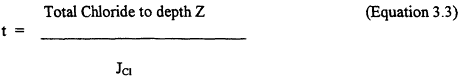
where the total chloride is calculated from the chloride concentration in the soil multiplied by the water content volume, and JCl is chloride input per unit time.
The chloride accumulation technique provides an integrated measure of the recharge and water flux through the unsaturated zone. While the technique is robust, it must be viewed in light of the assumptions used in its development. Clearly, the chloride accumulation rate must be well known or constrained for long periods of time. The chloride must be an ideal tracer of liquid water, i.e., vertical piston flow is required in the soil. Each of these assumptions is discussed below to assess their impacts on the outcome.
Chloride Accumulation Rate
The chloride accumulation rate is the rate at which chloride falls on the land surface in precipitation and dust. If the chloride concentration in the precipitation is (to first order) controlled by the distance to the ocean, its concentration at the Ward Valley site is unlikely to vary significantly with time. Under the current climatic regime, the precipitation at the site is approximately 12 cm/yr. This may have been up to 40 percent higher during the last 20,000 years (Hostettler, 1994). Under this scenario, the chloride flux due to precipitation could, conservatively, have been as much as 40 percent greater than the current rate. With this, we introduce an uncertainty of a factor of two in the age estimates.
Dry deposition of dust and salts will surely have varied over both short and long time scales. Studies in Nevada (Dettenger, 1989) suggest that the current chloride flux from dryfall is of the same magnitude as that brought in by precipitation. This can be taken only as a general rule as some areas could receive much higher or lower fluxes depending on local settings, elevation and proximity to local sources of chlorides. With the desiccation of many Mojave lakes at the end of the Pleistocene, it is likely that the dryfall component was greater than today. On the other hand, the presence of 36Cl in deep profiles at or near modem ratios found by Phillips et al. (1988) and Scanlon (1992) in other southwest U.S. sites would suggest that chloride dryfall did not dramatically increase. The dryfall question remains open and must be answered before confidence can be given to precise dating with chloride. The use of chlorine isotopic studies, both stable and cosmogenic, in the soil water may be very useful in this regard, as many saline lakes have 36Cl signatures very different from that of modem precipitation.
Non-Piston Water Movement
The chloride age requires piston flow for it to represent the age of the soil water, although, as described previously, field studies in humid climates have shown that water can migrate along preferential pathways created by roots, fractures or variations in soil texture. In such cases, some portion of the infiltrating water moves quickly through the soil, bypassing much of the soil matrix in the upper soil profile. Such events can lead to a chloride profile that also shows a chloride bulge near the surface. In this case, changes in the recharge rate did not produce the distribution, but rather the occasional introduction of low salinity water bypassing much of the upper soil matrix deeper in the profile produced the observed pattern. It is, therefore, not possible to assess the nature of soil-water movement on the basis of the distribution of chloride alone. Studies of chloride profiles must include an analysis of the likelihood for non-piston movement using other tracers or hydraulic indicators.
Chloride Data From Ward Valley
Chloride data from the Ward Valley site are discussed by Prudic (1994b). Chloride concentrations were measured in soil samples collected from six geotechnical borings (GB-1 to GB-6) to a depth of 30 m (LA Appendices 2500.A and 2600.A) (See Figures 2.4 and 2.5 for borehole locations.) No chloride data are available below a depth of 30 m. Bulk density and volumetric water content were not measured in the samples that were analyzed for chloride, so chloride concentrations in soil water were calculated using bulk density and volumetric water content from adjacent samples by Prudic (1994b) (Figure 3.4)
The chloride concentrations in the soil water were very high by comparison with localities with less stable surfaces or high precipitation, which suggests that the net subsurface water flux is small. If downward fluxes had been high, chloride would have been flushed out of the soil. Three of the boreholes yielded insufficient data to evaluate the depth distribution of chloride (one sample from GB-3; 4 samples from GB-5 and 3 samples from GB-6). Therefore, data from these boreholes will not be included in the following discussion. The chloride profiles are generally bulge-shaped with low chloride concentrations
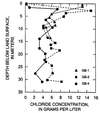
in soil water in the surficial sediments and maximum concentrations measured at 2.4 to 2.9-m depth in GB-2 (15 grams per liter (g/l)) and at 2.1 to 2.3 m in GB-4 (7.3 g/l) (Figure 3.4). Data from GB-1 differ from other data in that the maximum concentration in soil water was measured in the surface sample in GB-1 (at 0 to 0.3 m depth; 14 g/l).
Chloride concentrations in soil water decrease below the maximum to levels that range from 3.8 g/l in GB-4 to 8.2 g/l in GB-2. Prudic (1994b) calculated chloride ages based on data from boreholes GB-1 and GB-2 using a chloride deposition rate of 1.64 x 10⁻⁵g/cm2/yr (Prudic, 1994b). These ages increased from about 10 yr at 0.3 m to 52,000 to 58,000 yr at 30 m depth. Water fluxes estimated from the chloride data ranged from 0.03 mm/yr for GB-1 and GB-2 to 0.05 mm/yr for GB-4 below 10-m depth.
The two possible explanations for the bulge-shaped chloride profiles in Ward Valley are: (1) paleoclimatic variations in recharge with higher recharge in the Pleistocene and little or no recharge in the Holocene or (2) small-scale preferential flow diluting chloride below the peak. In the view of the committee, small-scale preferential flow is unlikely because of the dry nature of the sediments, with most water tightly adsorbed onto the grain surfaces. While preferential flow cannot be entirely ruled out, the high chloride concentrations suggest that percolation is extremely low at the site.
The likelihood of relatively high recharge during the Pleistocene with little or none in the Holocene is not incompatible with ages of ground water below Ward Valley that are considerably younger than the ''chloride accumulation age'', because the saturated-zone ground-water recharge zone was probably not in the immediate vicinity of the site.
Conclusions Regarding Chloride Data From The Ward Valley Site
The committee regards the chloride data analyzed from the three boreholes as evidence that percolation at the site is very small through the unsaturated zone. Percolation probably was very small in the late Pleistocene (30-10 ka) as well, based on the high chloride concentrations below the root zone evaluated by Prudic (1994b). The committee regards the bulge profile shape as most likely the result of changes in the climatic and recharge regime between 10 and 20 ka.
Tritium as a Soil-Water Tracer
Tritium, T or 3H, a radioactive isotope of hydrogen, has been used to trace soil- and ground-water movement since the early 1960's (Vogel and Ehhalt, 1963; Clayton and Smith, 1963; Münnich and Roether, 1963; Vogel, Ehhalt, and Roether, 1963). The basis for its use is the thermonuclear bomb testing during the late 1950's and early 1960's which produced relatively high tritium levels compared to the natural cosmogenic levels. The bomb tritium became incorporated into water molecules in the upper atmosphere as HTO, and joined the hydrologic cycle to provide what has become effectively a global radioactive tracer
experiment. Since about 1963, however, bomb tritium has been decreasing regularly, and is now close to "natural" cosmogenic levels.
In soil-water studies, researchers have generally relied on the location of the peak concentration to infer downward percolating water. Tritium concentrations are often reported in terms of "Tritium Units", or TU's, where 1 TU = 3H/H x 10-18 = 3.2 picocuries/kg Water. The half-life of tritium is 12.3 years. Thus, after one half-life, the concentration of tritium in a parcel of water would be half its original value, after two half-lives, 1/4 of the original value, etc. At its maximum in 1963, thermonuclear tritium exceeded 1000 TU in continental precipitation (Fritz and Fontes, 1980). Today's precipitation contains about 5 to 15 TU, depending on location and meteoric conditions.
Limitations of Tritium as a Tracer
Collection of water for tritium analysis from dry soils typical of interfluvial settings in add and semi-arid regions can be extremely difficult. Analysis of tritium can be done with as little as 4 mL of water (H. G. Östlund, Written Communication, 1989), or as much as 300 mL, depending on the technology used and the precision and detection limit required. This amount can be difficult to collect from dry soils. When water fluxes are very low, much of the water containing recent tritium may still be found in the root zone. In the root zone, velocities can be much higher than in the underlying sediments. As a result, the calculated water velocity may provide an upper limit for the deep soil-water velocity.(Tyler and Walker, 1994). If the bomb-produced tritium is solely contained in the root zone, however, this is a strong indication that percolation is minimal. Under conditions of non-piston movement, the tritium from recent infiltration may be spread vertically throughout much of the unsaturated zone and no peak can be identified.
Tritium daring of soil water is further complicated by the fact that HTO can move both as a liquid and as a gas. Even if liquid movement in the unsaturated zone is negligible, gas-phase transport can result in downward movement of tritiated water vapor. The presence of liquid water in the soil significantly reduces this movement (Phillips et al., 1988). As the tritium diffuses downward in the vapor phase, some tritiated water molecules exchange with water molecules in the liquid until they reach equilibrium. Because of the great disparity in the densities of water vapor (approx. 0.02 kg/m3) and liquid water (approx. 1000 kg/m3), most of the gas-phase tritium is taken up by the liquid through diffusive exchange. As a result, downward movement of tritium by diffusion in the gas phase should be greatly attenuated in most unsaturated zones.
Tritium Distribution in the Unsaturated Zone
Although the use of tritium in deep, unsaturated zones to infer rates of soil-water movement has several limitations, the distribution of tritium in the unsaturated zone can be used to derive information on the nature of water movement.
In general, tritium is distributed in three distinctive patterns. Under conditions of uniform or piston flow, one would expect to find a tritium peak perhaps slightly displaced from corresponding liquid water molecules infiltrated at the same time. If vapor phase dominates liquid-phase flow, the HTO may precede the H2O. But if liquid-phase flow dominates, HTO exchange with H2O that is tightly bound to days and other silicates will retard the tritium. If the tritium peak were found well within the root zone or just slightly below it, one could conclude that the percolation rate is low. Quantification of exactly how low, however, would require the use of other tracers and methods. If the tritium peak were well below the root zone, a simple estimate of the water velocity could be obtained by taking the distance from the land surface to the peak and dividing it by the number of years that had elapsed since the peak in tritium in the rainfall.
A third possible tritium distribution exists. In studies of percolation in Australia, Allison and Hughes (1983) measured tritium down to 10 m, well below the depth implied by other tracers and the general aridity of the region. They attributed the appearance of such deep tritium to some form of preferential or non-piston flow along root channels. A similar phenomenon has also been reported for fractured rock at Yucca Mountain, Nevada (Fabryka-Martin et al., 1993). These profiles generally do not show a well-defined peak and often exhibit a very erratic distribution; certain depths contain no measurable tritium while tritium is found in high levels immediately below. Such distributions of tritium, therefore, indicate water, in discrete zones, has had little time to be diluted by the surrounding soil water.
Tritium Measurements at Ward Valley
From Table 3.1 it is apparent that the highest tritium values were from water-vapor samples collected from the near-surface air piezometers. Also apparent from this table are finite tritium levels (greater than twice the ± figure) collected at depths as great as 30 m below the ground surface. Tritium detection at depth in the Ward Valley alluvium has been interpreted by the Wilshire group (Wilshire et al., 1993b) to be meteoric water labeled with "bomb" tritium, infiltrated to the collection depths. The license application states that the most probable explanation for tritium at this depth is gaseous diffusion. This committee concludes that neither explanation is correct, and that, as discussed below, the presence of tritium is most likely an artifact of the collection procedure. It is important to the discussion below to point out that the ± figures quoted in Table 3.1 do not indicate the total uncertainty for tritium in soil water, as implied in the footnote. Why this is true requires some background in the concepts of precision and accuracy.
First, accuracy and precision are related but distinctly different quantities. Accuracy of a measurement relates to how well calibrated an instrument is with respect to some absolute or defined standard. Precision is a quantitative statement of the uncertainty of the measurement. Tritium and 14C laboratories usually report only the precision of the laboratory measurement in terms of a number preceded by "±".
Table 3.1 Tritium Results for Unsaturated Zone Soil Vapor1
|
Date |
Air Piezometer |
Sample Depth (feet)3 |
Tritium Value2 (tritium units) |
|
6/26/89 |
GB-1 |
21.5 |
1.39 ± 0.57 |
|
6/26/89 |
GB-1 |
35 |
1.72 ± 0.51 |
|
6/7/89 |
GB-1 |
60 |
0.74 ± 0.41 |
|
6/6/89 |
GB-1 |
99.5 |
-0.01 ± 0.58 |
|
5/6/89 |
GB-4 |
16.5 |
5.60 ± 0.37 |
|
5/7/89 |
GB-4 |
58 |
1.37 ± 0.49 |
|
5/7/89 |
GB-4 |
99.7 |
1.02 ± 0.33 |
|
6/2/89 |
GB-4 |
16.5 |
6.00 ± 0.72 |
|
6/3/89 |
GB-4 |
58 |
1.15 ± 0.66 |
|
6/4/89 |
GB-4 |
99.7 |
1.18 ± 0.54 |
|
6/24/89 |
GB-6 |
18.5 |
3.94 ± 0.73 |
|
6/23/89 |
GB-6 |
33 |
2.07 ± 0.89 |
|
6/23/89 |
GB-6 |
59 |
1.38 ± 0.62 |
|
6/16/89 |
GB-6 |
99.7 |
1.66 ± 0.39 |
|
|
Air Moisture Sample |
6.91 ± 1.03 |
|
|
1 From LA Table 2420.B-10 2 Note: ± values are only laboratory uncertainties (1σ) associated with the tritium value 3 1 foot = 0.3048 m |
|||
Second, this ± figure from the laboratory, unless specifically stated otherwise, represents only the uncertainty of the laboratory measurement, and does not include additional uncertainties associated with the field collection procedure itself (see, for example, Long and Kalin, 1990). Thus the true uncertainty of the measurement can be assessed only by repeated sampling and remeasurement of the same level. This may not be possible because in this case, as explained below, the sampling process itself very likely affects the system under study. It is important for the reader to bear in mind that the stated ± figures are minimal, and the true uncertainties (level of accuracy) were not evaluated. They are certainly greater than the reported values.
The procedure for collecting water from the unsaturated zone at the Ward Valley site involved the pumping of soil gas from air piezometers at specific depths through plastic robing. The collected water vapor is then condensed in the solid phase in a cold trap at liquid nitrogen temperature (about -180°C). Collection continued for each sample at 1500 liters (1) of air per hour until 40 milliliters (mL) of liquid water were collected. This required 4 to 8 hours of collection. Thus 6,000 to 12,000 liters of soil gas passed through the collection apparatus for each water sample for tritium analysis (LA Appendix 2420.B, Figure 2420.B-6).
In view of the importance of the possibility of significant amounts of vertical movement of tritium (water) in the unsaturated zone, it is necessary to consider all possible explanations for the observed tritium data: Several possible explanations evident to the committee for the reported tritium found at depth in the soils at Ward Valley include:
1. Infiltration of liquid-phase water within the past 40 years to a depth of at least 30 m: The highest tritium values in the profiles (up to 6 TU) are the shallowest ones in the profile. Tritium values regularly decrease with increasing depth. Irregularities with this trend are not statistically significant. This pattern is consistent with liquid-phase vertical infiltration of precipitation containing moderately low values of tritium. The bomb pulse is not clearly apparent in these profiles, as its maximum would have decayed only to somewhat greater than 200 TU by the time these samples were taken and measured (1989). Ages for water estimated from the chloride data indicate that under piston flow conditions the bomb tritium peak should be found in the upper 1 to 2 m of the soil. However, dispersion and mixing of the bomb-derived tritium-rich liquid water with tritium-free liquid water could have produced the observed tritium profile. The tritium profile could also represent very recent infiltration and dilution with tritium-free water that had been in the unsaturated zone for over 40 years. A finite level of tritium (>2 standard deviations above the detection limit) (See Box 3.2 for discussion of standard deviation) was reported at 30 m. in boreholes GB-4 and GB-6. If this represents advective liquid movement in the unsaturated zone, it is inconsistent with the limited soil physics and chloride data at the site and with the applicant's conceptual model of water movement through the unsaturated zone.
2. Diffusion of gas-phase water through the unsaturated zone: The license applicant proposes a vapor-phase diffusion model to explain the observed tritium profiles in the upper 9 m of the unsaturated zone (Harding Lawson Associates, 1990).
Modeling of the tritium found in boreholes GB-1, 4 and 6 contained in the license application and in a letter report (Harding Lawson Associates, 1990) does not account for the interaction of gas- and liquid-phase tritium, which has resulted in a significant overestimation of tritium migration. This was correctly pointed out in Wilshire et al. (1994). The committee conducted modeling calculations, which included the effects of liquid interaction, and concluded that gaseous diffusion of tritium will be limited to only 1.5-3.0 m below the land surface at the Ward Valley site. Therefore, the vapor phase diffusion proposed in the license application as a mechanism to explain the observed tritium profiles does not explain the observations.
|
Box 3.2 STANDARD DEVIATION A standard deviation, abbreviated as σ (sigma), is a statistical statement of the precision of a measurement, assuming that all possible measurements of a quantity, for example the tritium content of a water sample, would have a "normal" or bell-shaped distribution about the true value. Because each water sample was measured only once, the numerical value of the standard deviation is a statement of the uncertainty of the measurement. In the case of tritium measurements, the value is based on the number of tritium decays measured by the analysis laboratory as well as on the repeat analysis of standards and laboratory blanks. The value does not, in the case of these tritium samples, represent variability and uncertainty in the field collection and processing. The implication of this statistical phenomenon is that, in the case of the values that the laboratories reported for the standard deviation, for example, 10±1 (1σ), the probability is about 68% that the true value lies between 9 and 11. Correspondingly, for 2σ, or 2 standard deviations, the probability is about 95% that the true value lies between 8 and 12. Stated another way, the probability is about 5% that the true value lies outside of the 8 to 12 envelope. Still another statement from this example, the probability is about 2.5% that the true value is less than 8. In the case of distinguishing finite levels of tritium from no measurable tritium, the 2σ criterion is used, giving one an approximate 95% confidence that the two normal curves (representing blank and sample) do not overlap. |
More recent modeling to correct their earlier analysis (Harding Lawson Associates, 1990) that led to the vapor phase model concurs with the committee's findings and suggests "that only very limited downward transport of tritium occurs in the vapor phase". In addition, a fully coupled two-phase simulation was conducted that is a more correct and comprehensive interpretation of the diffusion process. The two-phase approach included the additional effects of liquid diffusion. Using this approach, the modeling results were reported to indicate "that some of the measured tritium concentrations in piezometers may be attributed to background levels ..." (Harding Lawson Associates, 1994b), where background refers to tritium which has moved by diffusion from the land surface.
The two-phase modeling approach is conceptually correct, although the liquid diffusion coefficients used in simulations are much larger than would be expected in the dry soils at Ward Valley. Two diffusion coefficients were used, 1.49 cm2/day and 4.47 cm2/day. These values (Harding Lawson Associates, 1990) were intended to represent the liquid diffusion coefficient of tritium in the soil, but the values represent the approximate, free-water diffusion coefficient and three times the free water diffusion coefficient, respectively, as reported by Gvirtzman and Margaritz (1986). It appears that an error was made in the Harding Lawson Associates letter report (1990), which calculated a free-water diffusion coefficient for tritium of 42.5 cm2/day. In contrast, Gvirtzman and Margaritz (1986)
suggested a free-water diffusion coefficient of 1.5 cm2/day, a factor of almost 30 lower. Based on the same tortuosity as reported in the more recent Harding Lawson Associates letter report to the committee (1994b), the committee calculations resulted in an appropriate value for liquid-phase diffusion of tritium in the soil of 0.05 cm2/day, much lower than that used in the two-phase modeling. Using the correct diffusion coefficients significantly reduces the enhancement of liquid diffusion in tritium transport. As a result, it is virtually impossible that the tritium reportedly found in the boreholes can be explained by either single- or two-phase gas and liquid diffusion only.
3. Barometric pumping: Barometric and thermal pumping (Weeks et al., 1982) due to atmospheric conditions is inadequate to explain tritium at the observed depths, because wind and evaporative processes affect only the first meter or two below the surface (Weeks et al., 1982). Concentration-gradient driven diffusion is the mechanism of greatest importance for gas transport in the unsaturated zone.
4. Artifact of collection procedure: The collection procedure itself could affect the level of tritium reported in the unsaturated zone. The large volumes of air removed from the unsaturated zone (up to 12,000 liters per sample taken over a period of up to 8 hours per sample) would remove air from the immediate vicinity of the sampling point, in homogeneous media, from a sphere surrounding the collection point. This sphere of extraction, in the case of the soil air sampled for tritium analysis at Ward Valley, would have a radius ranging from about 2 to 2.5 m, depending on the volume collected, and assuming an average porosity of 27 percent and an average water content of 7 percent in homogeneous media. The Ward Valley alluvium consists of variable mixtures of poorly sorted sand, silt, gravel and clay, as described in the license application. Inhomogeneity would distort the ideal sphere. Alluvial sediments tend to have greater textural variability vertically than horizontally. This would tend to flatten the ideal sphere and extend it horizontally. Textural variability in alluvium can also create preferential pathways in a vertical direction, but less commonly. Even microfissures and near-vertical cracks, which are unable to transmit water under unsaturated conditions, can easily conduct air under pressure differential. Microfissures, though not identified in the site characterization, are not uncommon in alluvial sediments. A third possible pathway is along the annulus of the borehole casing. This could occur if the space between the outer surface of the casing cylinder and the sediments is incompletely filled with grout. Such a possible leakage pathway need not extend to the ground surface, and thus could be concealed.
The grout itself is unlikely to be a source of tritium, as tritium-free water was used in its mixture. The air used during the "dry" drilling process contained about 6 TU. The relative and absolute humidity of the air in Ward Valley is normally very low. At 30°C and 10 percent relative humidity, the atmosphere at Ward Valley contains 3 mg/1 of water. Therefore, some atmospheric tritium may have been transferred to depth during the drilling process, and this could have contributed to the non-zero tritium measurements observed. Were this an important addition to the tritium in the unsaturated zone, the second samplings from GB-4 would have showed significantly lower tritium than the first. This was not observed.
In summary, when soil-gas is extracted at depth from an air piezometer, the locality from which the gas is removed is indeterminate without complete knowledge of the textural
variations and structural integrity of the sediments in the immediate vicinity of the sampling point, and of the degree of perfection of construction of the piezometers.
The low sampling yields (about 40 percent of the expected volumes of water) are consistent with mixing of the soil gas with low-humidity atmospheric air during sampling of the boreholes. Also consistent with this possibility is the fact that the highest values collected (5.6 and 6.0 TU at a depth of 5.1 m from GB-4) are only slightly lower than the measured tritium content of the ambient air (6.9 TU). The committee concludes that the possibility of atmospheric contamination of the samples in the uppermost levels of the unsaturated zone is likely, given the low levels of tritium observed and the low sample recovery. As discussed above, these results are also consistent with small amounts of recent infiltration to these shallow depths.
Atmospheric contamination may have affected the tritium measured at the collection points nearest the land surface (at 5 or 6 m), but it is difficult to apply these processes as possible explanations for tritium found in the deeper levels (11 to 30 m). Even considering variability in soil texture, the volumes of air in the sediments within a few meters of the piezometer sampling points are many orders of magnitude greater than the maximum volumes of air sampled for tritium analysis.
The only leakage pathway that could bring atmospheric air into the deeper air piezometers would be along the borehole casing. The committee considers this pathway to decrease in likelihood with increasing depth. The similar pattern of observed tritium in each borehole, namely decreasing with depth to, or almost to, the detection limit, is also consistent with each soil-gas sample representing the tritium level in the unsaturated zone at the collection depth.
It is thus not possible from the data available to conclude that the observations demonstrate infiltration during the latter half of the 20th century. The question then rams to the integrity of the tritium measurements on the deeper soil-gas samples: can the available tritium data allow us to distinguish between the two hypotheses for the measured values of tritium at or below 11 m in the unsaturated zone? The hypotheses are: (1) tritium, and thus meteoric water infiltrated to at least 30 m within the past 40 years, and (2) the reported tritium values lie within the analysis system blank, and therefore these values do not represent infiltration.
Procedural Blank and Uncertainty in The Blank
To verify the level of accuracy of the instruments and measurement procedures, it is necessary to obtain a procedural blank. Procedural blank determination in any analytical measurement is necessary to evaluate and interpret the significance of the result. This is done by using the instruments and procedures to measure a solution known to be free of the substance to be measured. False positive measurements then can be incorporated as the error values to be expected. The closer the expected value of the field measurement is to zero, the more critical is the blank determination.
All analytical procedures, especially those dealing with very low levels of the measured substance, require special attention to all steps in the procedure, beginning with the collection and handling, and ending with the analysis and reporting (Taylor, 1987; Long and Kalin, 1990). Laboratories typically report only the laboratory analysis portion of the uncertainty because that is the only series of steps they have control over. Table 3.1 gives the laboratory uncertainties. The report of the analyses in the license application (LA Section 2420.B, Table 2420.B-10) makes no reference to a procedural blank for assessing the true total precision of the analytical and collection procedures. Thus the total uncertainty (± figure) and blank2 level for tritium for these analyses using the procedure described, are unknown. What is known is that the total analytical uncertainty, including collection, is either the same as reported in Table 3.1, or greater. In the committee's view, field collection procedures employed here may have added more uncertainty to the data, and the true uncertainty in the blank value, i.e. the real ± figure, is greater than reported in Table 3.1. For example, any joints in the sampling instruments must be vacuum-tight to prevent surface air from being entrained in the sample stream. To establish a collection procedure blank requires application of identical procedures to a hydrogeologic system for which one has prior knowledge of undetectable tritium. It is tempting to suggest that the 30-m sample from GB-1 is the value for the blank, and all others are finite. However, a single analysis cannot constitute sufficient information on which to base an estimation of the total analytical uncertainty and blank value. The true value for the tritium blank using this procedure remains unknown.
It is thus inappropriate to conclude from these data that the levels of tritium reported at or below 11 meters are either evidence for small amounts of post-1950 infiltration or simply within measurement uncertainty of zero. The tritium levels reported at depths above 11 m are consistent with small amounts of infiltration to those depths, but are also consistent with the samples that have incorporated some atmospheric water vapor during the sampling procedure.
Conclusions Regarding Tritium Found M The Unsaturated Zone
In the committee's judgement, the gaseous diffusion model presented in the license application as the most likely explanation for tritium at depth in the unsaturated zone is incorrect. Infiltration of meteoric water, as the Wilshire group suggested as the explanation of tritium at depth, is inconsistent with chloride and water potential data. In the committee's opinion, a likely explanation of the reported tritium at depth is sampling and procedural practices. The very low tritium values at depths below 11 m
reported in the license application are meaningless without the determination of a procedural blank for the method used to collect the samples. Thus these tritium measurements cannot be used to infer infiltration.
In light of plans to monitor tritium during site operation, the explanation for the reported tritium values should be resolved before the site monitoring begins. Other tracers, such as 36Cl, have successfully been used elsewhere to constrain the magnitude of liquid water movement in the unsaturated zone and should be considered. Sampling for 36Cl can be accomplished much more readily than for tritium at the Ward Valley site because large quantities of water are not required for analysis and chloride concentrations in the soil water are extremely high.
Conditions at Homer Wash
Features such as Homer Wash represent areas of likely higher fluxes and recharge. Periodic surface flow combined with coarse-textured soils at the surface and lack of extensive vegetation at the bottom of the wash provide an excellent opportunity for moisture to move below the zone of active evaporation and root extraction. Therefore, the observed lower resistivity zone beneath Homer Wash is most likely caused by higher water contents at depth. While the water content of the unsaturated zone may be relatively high, a continuous reflector detected in the seismic survey across Homer Wash and coincident with the water table indicates that the water table is not significantly higher beneath Homer Wash.
The committee agrees with both Wilshire et al. (1993) and the California Department of Health Services (1994) that active ground-water recharge may be occurring beneath Homer Wash. Inasmuch as Homer Wash is 760 m laterally from, and 10-15 m below, the base of the proposed disposal trenches, the committee concludes that such recharge is unlikely to have significant impact on water movement directly beneath the disposal site.
It should be pointed out, however, that although recharge from Homer Wash would not affect releases of radionuclides from the site nor water movement directly beneath the site, it probably would affect ground-water flow patterns in the saturated zone. One such effect might be to reduce or eliminate ground-water movement from the west, up-slope side of Homer Wash (where the site is located) eastward to the Colorado River, if such pathways actually exist, because of a possible hydraulic barrier effect of recharge from Homer Wash.
Summary of Subissue Conclusions
-
Based on the data presented in the license application and supporting documents, the committee concurs with the conclusion that water flux in the upper 30 m of the unsaturated zone is extremely low. This conclusion is based on the observations of low water content, low water potential, limited infiltration during the
-
monitoring period, and the significant accumulation of chloride in the upper 30 m of the unsaturated zone. Monitoring hydraulic parameters in dry desert soils is complicated. Monitoring instruments such as thermocouple psychrometers and heat dissipation probes are not robust and have a high failure rate. Although many problems were associated with the instrumentation at the site, particularly the monitored water potentials, all the water potentials monitored by the psychrometers fall within the dry range (-3 to -6 MPa). In these very dry systems, the level of uncertainty in hydraulic parameters that can be tolerated and still have little significance with respect to water fluxes is higher than in much wetter systems.
The committee concludes that monitoring of the unsaturated zone using corrected methodologies and equipment should have been continued after submission of the license application to provide a more complete data set. The committee also concludes that baseline data from a greater depth in the unsaturated zone should be collected as part of the monitoring program at the site.
-
Because of the extremely low water fluxes, it is difficult to resolve the direction and rate of water movement at the Ward Valley site. The license application states that the direction of water flow is upward; however, problems with the thermocouple psychrometers at the site made it difficult to determine the water potential gradient. In the committee's judgment, the most likely current direction of water movement at the Ward Valley site is upward. We based this on the low water potentials observed and the fact that similar sites in arid regions have vertical matric potential gradients in the unsaturated zone which drive the water vapor upward.
-
Based on model analysis, the committee concludes that the presence of tritium in the deeper portions of the unsaturated zone cannot result from vapor diffusion as stated in the license application. After consideration of several other possible explanations for the measured tritium, the committee concludes that the experimental design for collecting tritium from soil gas is seriously flawed, and this is the likely explanation for the observed tritium profiles below 11-m depth.
The committee also appreciates the difficulty of making applicable blank runs using the water-collection procedures used for the license application. Thus we recommend that future unsaturated-zone tritium measurements employ vacuum distillation collection procedures similar to those described in Yang (1992), or other direct water-isolation procedures. Any future attempt at collecting tritium samples must establish procedural blanks and evaluate potential contamination problems, so that a true positive value can be identified. We further recommend that tritium measurement techniques other than β-counting be investigated. Two such approaches, still under development, may enable more sensitive measurements using smaller samples of water. These include the 3He-ingrowth method and accelerator mass spectrometry (AMS). These may be adaptable for unsaturated-zone monitoring. Additional analyses and data from tracers such as 36Cl could help resolve this issue of unsaturated-zone infiltration.
-
The committee concludes that recharge at Homer Wash is possible but is unlikely to affect the ability of the site to isolate the wastes in the unsaturated zone.
EVIDENCE FOR RECHARGE TO THE GROUND WATER BENEATH THE SITE
Observational Methods
Direct observation of soil-water movement is generally impossible without disturbing the system. However, when soil water reaches the water table, this recharge can omen be detected in the hydraulic and geochemical response of the uppermost part of the ground-water flow system. Such response could include the appearance of a contaminant or tracer from the surface in a monitoring well, changes in the ground-water chemistry, rises in the water table following a recharge event, or by a vertical hydraulic gradient in the aquifer. In general, these techniques do not provide quantitative evidence of flow, but rather are useful qualitative indicators.
Tracers commonly used in arid zone ground-water studies are similar to those used in the unsaturated zone and include tritium (3H) (indicative of recent recharge), 14C (indicative of the approximate age of the ground water) and the stable isotopes of water, deuterium (2H) and 18O (to indicate climatic conditions during recharge). The Wilshire group drew attention in particular to the 14C age dating technique used in the license application, which concludes that the ground water is very old and could not have been recharged under the present-day climate (Wilshire, 1993a, b, 1994). In addition to these tracers, the committee has reviewed other indicators of recharge at the water table that were discussed in the public meetings of the committee or have come to light in our review of data.
Tritium in the Ground Water
As a chemical tracer in hydrologic studies, the presence of tritium (>0.2 TU) in ground water indicates recharge during the past 40 years. The 12.3 year half-life of tritium makes it ideal for tracing young waters or identifying young (<40-year old) components in mixtures. This makes it possible to determine if ground waters are less than 40 years old, or if they have had significant input of meteoric waters during the past 40 years.
Water samples from zones 5 to 65 m below the water table were taken from the monitoring wells in order to establish whether recent infiltration had reached that level. If tritium were found above background levels in these samples, it would be positive evidence for infiltration of water during the previous 40 years. With one exception, all ground-water samples were within the limit of detection of the laboratory analysis (1 TU). The exception, 3.7 ± 1.0 TU, was one of two duplicate samples from well WV-MW-04. The other duplicate sample, collected on the same day, yielded 0.0 ± 1.0 TU. The license application states that the finite analysis is spurious in light of the fact that the duplicate and all other tritium samples from the saturated zone yielded no measurable tritium. This statement is corroborated by freon measurements. Freons, which are man-made gases, are present in ground waters recharged in the second half of this century. Freon determinations were negative in all water samples from the monitoring wells at the Ward Valley site.
An alternative point of view was presented in one of the committee's open meetings (Committee to Bridge the Gap, 1994) suggesting that more sensitive tritium measurement technologies should have been used to enable detection of lower proportions of recent recharge in the ground water. However, due to the possibility of in situ tritium production, measurements <0.2 TU would have ambiguous interpretations (Lehmann et al., 1993).
Conclusions Regarding The Observation of Tritium In The Ground Water
In light of other tritium analyses on samples taken from the monitoring wells, all within about 1000 m of each other, that showed no measurable tritium, the committee concludes that the one 3.7 TU value is likely in error. In any low-level radioactivity measurement, a false positive is more likely than a false negative. The tritium data, therefore, do not indicate recent recharge to the ground water at the site.
Carbon-14 Age of the Ground Water
14C has been widely used to date ground water, although ground-water 14C analyses are not straightforward enough to interpret in terms of time since recharge. The results presented in the license application were on water collected from monitoring wells penetrating the same hydrologic unit, and located within about 1000 m of each other. These ages, with no model-based adjustments, range from 12,560 ± 750 to 16,920 ± 590 years (LA Appendix 2600.A). Subsequent analyses provided to the committee in a report (Grant Environmental; 1994) revised these age estimates according to several model age-adjustment protocols to range from 4,500 years to 22,000 years.
The 14C data on ground water, taken from the dissolved inorganic carbon (DIC), can be interpreted only in the context of hydrogeochemical models. As the available data do not unequivocally reveal recharge areas or even flow directions for Ward Valley, we discuss the data more generally in terms of a likely hydrogeochemical scenario. A viable general model for ground-water flow and geochemical interaction for ground-water alluvial aquifers in add and semi-add basin-and-range valleys involves: (1) recharge near mountain fronts, (2) possible recharge beneath drainageways (streams and washes), (3) possible recharge through alluvium, (4) chemical interaction between ground water and aquifer minerals, and (5) gas/liquid-phase interaction between water in the saturated zone and gases in the unsaturated zone. In the context of this general model, one can evaluate the likelihood of these processes, in addition to radioactive decay, affecting the ratio of 14C to total measured carbon (14C/CTOT, usually expressed as percent modem carbon, pMC) in the DIC.
-
Mountain-front recharge water derives its DIC from dissolution of soil gas CO2, which has a 14C/CTOT equal to or nearly equal to that of the atmosphere (Fontes, 1992; Kalin, 1994). Some dissolution of calcite may occur in this environment, which would reduce the
-
14C/CTOT, but isotopic exchange with gas-phase CO2 from plant respiration tends to return the 14C/CTOT in DIC back to modem levels.
-
Recharge at drainageways, like Homer Wash, through the unsaturated zone to the water table would act as a short circuit and mix possibly younger water with older water in the saturated zone. The resulting mixture would have a higher 14C/CTOT (higher pMC) of the DIC, thus decreasing the apparent age.
-
Recharge through the alluvium would have the same effect as process 2 on the apparent ground-water age.
-
Chemical reactions in the aquifer either have no effect on the apparent 14C age (for example, incongruent dissolution of silicates or precipitation of calcite), or increase the apparent age (for example, dissolution of calcite or oxidation of lignite). These reactions, and their effects on the 14C/CTOT, can be modeled, but only if a downgradient sequence of water samples is available. NETPATH (Plummer et al., 1991) was designed for this purpose.
-
14C/CTOT of DIC in the saturated zone could be affected by dissolution of, or exchange with, CO2 in the unsaturated zone. This process could operate throughout the entire basin. Fontes (1992) stated that this would be most pronounced in cases of high pH ground water. Kalin (1994), who modeled reaction paths in the Tucson Basin in Arizona using NETPATH, did not find CO2 exchange to be important in the Tucson Basin. In the case of the Tucson Basin, the samples were from wells used for water supply and were completed deeper below the water table than the monitoring wells at Ward Valley. WATEQ (a subroutine in NETPATH) analyses of the ground water from the Ward Valley monitoring wells (Grant Environmental, 1994) revealed that all water samples were essentially in equilibrium with calcite. This suggests that calcite dissolution may have affected and (probably decreased) the 14C/CTOT of the DIC for the Ward Valley samples.
Because of the overall lack of hydrogeochemical constraints on the processes discussed above, including large uncertainties in δ13C and 14C/CTOT values in soil-zone CO2 and in aquifer carbonates, and because of the possibilities of DIC 14C/CTOT alteration by processes discussed above, we cannot place confidence in any specific ground-water age. However, if significant surface water had infiltrated in the vicinity of the Ward Valley proposed site within the past few thousand years, but before the nuclear weapons-induced pulse in 1960, the water-table surface would reveal 14C levels in the 50 to 80 percent modem carbon (pMC) range. This results from reactions of DIC with aquifer carbonates. Pre-1950 atmospheric CO2 and living plant tissue had 14C concentrations of 100 pMC; aquifer carbonates can range from 0 to 100 pMC. Measured values of 14C in the water sampled from the monitoring wells ranged from 11 to 22 pMC (Grant Environmental, 1994).
Because processes other than radioactive decay can affect the apparent radiocarbon age of ground water, 14C may not be an ideal tracer of recent recharge. Exceptions to this are systems that undergo insufficient carbon-diluting processes that may attenuate the ''bomb pulse'' to levels below 100 pMC. In other words, the following conditions must be met for 14C in ground water to be useful in identifying vertical recharge during the second half of this century: water infiltrated from the surface near the proposed site vertically to the water table, all within the 1958 to 1989 time frame, without dissolving enough soil/unsaturated-zone
carbonate or without mixing with enough existing saturated- or unsaturated-zone water to lower the bomb pulse to <100 pMC.
Ground waters that are chemically or isotopically stratified are difficult to sample without mixing waters of different ages and/or sources. This likelihood complicates the meaning of "ground-water age." For example, waters sampled from the monitoring wells were screened over a vertical distance of 14 m. The upper limit of these screens ranged from 5 m to 68 m below the water table. Mixing of waters of different ages and possibly different sources (long versus short travel times) is often a possibility. Consequently, in the case of mixtures, an infinite number of water mixtures of different "ages" is possible. A small proportion of "post-bomb" carbon could be concealed in a composite water with measured pMC values of 22 or even 11. Therefore, it is often impractical to calculate or assign a precise age to ground water. This is true for the Ward Valley data.
The two adjacent monitoring wells (WV-MW-01 and WV-MW-02) are screened from 5-17 m and from 60-70 m below the water-table surface, respectively. Two rounds of sampling were conducted on these wells. In the first round, samples from these two wells were not significantly different in 14C/CTOT (MW-01:10.9 pMC; MW-02:11.3 pMC), which suggest no vertical gradient in 14C. However, the major-element chemistry reveals marked differences between these two waters. The Round 2 sample, however, from MW-01 (17.5 pMC) was significantly higher than the Round 1 sample (10.9 pMC). This apparent vertical stratification, whereby the upper portion of the aquifer was higher in 14C than the lower, manifested itself only under pumping conditions. This has been seen elsewhere (Mazor, 1991) and suggests that the waters at the top of the water table were recharged more recently than deeper waters. As the Ward Valley wells were not screened slightly below the water table, it is not possible from the data to date this uppermost water.
Based on the information available, the committee finds it is not possible to rule out any of the ages presented in the license application, or to rank them in terms of relative likelihood. A fair statement is that the mean age of the ground water sampled beneath the Ward Valley proposed site is covered by the range of model ages presented in both the license application and subsequent documents; i.e. between 4,500 and 22,000 yr. However, because of the possibility of the water samples being mixtures of different ages, the Ward Valley 14C data cannot unambiguously demonstrate the presence or absence of modern recharge. A Holocene or Pleistocene age of ground water below Ward Valley does not necessarily indicate local recharge, because groundwater flow paths are very long and much of the ground water presently beneath the Ward Valley site probably originated from recharge in higher elevation regions.
Stable Isotopic Composition of Ground Water As An Indicator Of Its Age
The stable hydrogen and oxygen isotopic composition of water can give important information about the origin of water. In particular, several important generalizations can be made about the origin of surface water based on the contents of deuterium (D or 2H), a heavy isotope of hydrogen (H), and of oxygen (18O) isotopes of such waters, where δD is:
and H is the light isotope (1H) of hydrogen, D is the heavy isotope (2H) of hydrogen, and SMOW is the international isotopic standard for water (Standard Mean Ocean Water). The equations defining δD, δ18O, and δ13C are analogous. The units used are deviations from the SMOW reference for δD and δ18O, and from the PDB reference in the case of 13C. The values represent parts-per-thousand (‰) deviation from the respective stable isotope ratio standards.
Three types of water, with characteristic δD/δ18O patterns, are important in this discussion: (1) Waters in which δD and δ18O values lie on the meteoric water line (MWL), so called because most precipitation falls very close to the line (Figure-3.5), and can be defined as
This is an empirical relationship. Each watershed could have its local meteoric line with characteristic slope and intercept. (2) Waters that are relatively enriched in δD and δ18O due to evaporation fall on a trend with a δD/δ18O slope less than 8 and between 3 to 5 and intersect the MWL. (3) Waters that have undergone extensive water-rock interaction and are enriched only in δ18O (Figure 3.5). Normally, extensive water-rock interaction is restricted to geothermal waters.
Ward Valley Stable Isotope Data
The data in the license application come from five ground-water wells, each of which was sampled on two dates (January-February 1989 and May-June 1989). The reproducibility of the δ18O of water samples does not seem to be as good as is quoted, especially for replicate samples analyzed by different laboratories. The committee considers that the data from WV-MW-02,03,04,05 are not distinguishable from each other and can be considered to be a single point. WV-MW-01 (the sample with the most positive δD value for both sampling dates) is,
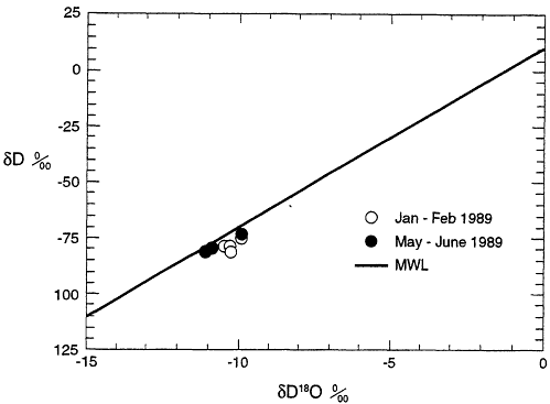
Figure 3.5 The isotopic composition of well water from the Ward Valley site in 1989 as reported by the Alberta Environmental Center. The solid line shows the meteoric water line (MWL) of Craig (1963). All samples plot very close to the MWL and are not distinguishable from meteoric water from southeastern California (collected by Smith et al., 1992).
however, distinguishable from the other water samples. It is also the sample closest to the water table.
The samples plotted in Figure 3.5 are very close to the meteoric water line, indicating the isotopic composition of non-evaporated waters in the region. The δD and δ18O values are about -78 and -10.8 per rail, respectively, which is in the cluster of values found by Friedman et al. (1992) and Smith et al. (1992) for modem meteoric waters in the region. This δD value is similar to that of winter precipitation near Needles, CA, as shown in Figure 5b of Friedman et al. (1992) and is significantly higher than summer or mean δD values for the region.
The entire range of δD and δ18O for all five wells is 7.0 per mil for δD and 1.1 per mil for δ18O (using only data measured in the laboratory at Alberta Environmental Center (AEC). This small range, especially when the samples are so close to the meteoric water line, is not enough to determine if the waters had undergone significant evaporation after falling as rain.
Unfortunately, no "blind" duplicates were run in the Alberta laboratory, so that the true uncertainty is not known. The single sample that can be clearly identified as being a duplicate is from monitoring well WV-MW-05 analyzed by Global Geochemistry Corporation (GGC). The δ18O value for that sample differed by 0.65 per mil between the two laboratories
(in the original data sets, WV-MW-05 4 Feb 89 is -10.45 by AEC, and -9.8 [average of-9.9 and -9.7] by GGC). The uncertainty in the true accuracy and precision of the δ18O measurement is in doubt, but given the paucity of duplicate analyses, it is certainly higher than the quoted uncertainty of ± 0.2 per rail.
Three samples (WV-MW-03,04,05) yielded δ18O values that were 0.4 to 0.5 per mil depleted in the May 1989 sampling compared to the February 1989 sampling. This slope is characteristic of waters with high water/rock ratios, such as in geothermal systems, although the direction of the depletion is wrong since the sample should become more enriched through time. It is not characteristic of evaporation. However, it is most likely that these differences are within the true uncertainty estimates for this data set as shown by the differences in δ18O between different laboratories on the same sample and later samplings of the same wells.
Estimates of Paleotemperatures Using The Claussen Approach
The license application proposed that the stable isotopic composition of the ground water can be used to infer the average annual air temperature at the time of recharge as proposed by Claussen (1986). In the committee's judgment, the Claussen (1986) approach to estimating the paleotemperature of recharge is inappropriate for this study. Claussen (1986) used δD and δ18O values for monthly mean temperatures at a single mountain site in Colorado, where climatological conditions are vastly different from those at Ward Valley. Compilations of δD, δ18O, and temperature data by the International Atomic Energy Agency (IAEA) (1981) and discussions of such data by Rozanski et al. (1992), show that the Dd18O/ΔT slopes are quite variable, and that the intercepts vary significantly even for stations with similar meteorology (e.g. Chicago, Illinois, and Ottawa, Canada) resulting in distinctly different recharge temperature estimates using the Claussen (1986) approach. In addition, site-specific variables such as differential infiltration of summer versus winter rains, as well as differences in storm-track patterns between glacial and interglacial periods, add even greater uncertainty to this type of calculation. The local meteorology of the Mojave Desert Ward Valley region is completely different from the mountainous Colorado site. The IAEA (1981) data for North American non-coastal sites using the Claussen (1986) approach give a range of inferred recharge temperatures for Ward Valley extending over 50°C (90°F). These calculated temperatures illustrate the futility of the Claussen (1986) approach (Table 3.2).
Conclusions Regarding The Stable Isotopic Signature of Ground Waters
In the committee's view, the δD and δ18O data show that the isotopic composition of ground water in the region is indistinguishable from local meteoric water or from Holocene water. They do not provide an estimate of recharge temperature, nor do they provide any evidence of post-precipitation evaporation.
Table 3.2 Regression data and calculated recharge temperature at Ward Valley. Data from Claussen (1986) and the International Atomic Energy Agency (1981).
|
Location |
Regression Equation |
Recharge Temperature*(°C) |
|
Claussen (1986) |
δ18O = 0.57 T - 15 |
7.0° |
|
Chicago (IAEA) |
δ18O = 0.35 T - 10.62 |
-1.1° |
|
Flagstaff (IAEA) |
δ18O = 0.34 T - 9.80 |
-3.5° |
|
Ottawa (IAEA) |
δ18O = 0.32 T - 13.25 |
7.0° |
|
The Pas (IAEA) |
δ18O = 0.40 T - 19.2 |
20.5° |
|
Waco (IAEA) |
δ18O = 0.14 T - 6.37 |
-33.1° |
|
IAEA (global MAT) |
δ18O = 0.56 T - 12.7 |
3.0° |
|
* Estimated paleotemperature of recharge at the Ward Valley site, calculated assuming a δ18O value of-11 per mil |
||
Water Chemistry Changes
Although not commonly used to measure recharge, observed changes in ground-water chemistry can indicate recharge through the unsaturated zone. In recent years, monitoring ground-water quality has become routine at many industrial sites to detect if ground water has become contaminated by surface activities. If ground-water movement is slow compared to recharge velocities, chemical changes in the upper portion of the aquifer may be the result of recharge.
The geochemical composition of ground water is determined in large part by the mineral dissolution reactions that contribute ions to the water system. Dilution and mixing with other ground water are means to change significantly and quickly the chemistry of ground water. For certain ions, anthropogenic input can significantly alter their concentrations (e.g., notably Na+ and Cl-). Other ions are considered to be nutrients and are closely related to biological activities at the earth's surface. These include nitrate (NO3-) which can also be greatly affected by human activity. Other species, notably silica, are generally well buffered in ground water and change their concentrations due to dissolution of silicate minerals (although not quartz). Silica is not generally affected by human activity.
Chemical Variations In Ward Valley Ground Water
The license application and a letter report (Harding Lawson Associates, 1994a) conclude that the chemical variations are not the result of recharge events to the water table.
The letter report also concludes that the lack of seasonal trends in chemical variability can be used to support the hypothesis of no current recharge. In a deep unsaturated zone where precipitation is highly variable, seasonal response of the water table is, however, not expected.
The geochemistry of ground water from monitoring wells WV-MW-01 to -05 was reported in the original site license application and supplemented with data contained in a letter report (Harding Lawson Associates, 1994a). Although sufficient to discuss general aspects of the regional water chemistry, the data are not precise enough to determine if small changes occurred in water composition through tune. Special care must be taken in sampling and chemical analysis to determine small changes in water composition through rune. In addition, much higher precision would be needed than is normally provided by commercial laboratories.
The monitoring well chemistry shows considerable variation in certain chemical constituents (silica, total dissolved solids, nitrate, and bicarbonate), electrical conductivity, and temperature. Some portion of the variability can be ascribed to analytical precision in the laboratory, which is to be expected, or to field measurement errors. Duplicate samples sent to several different laboratories show that agreement for some species is very poor among laboratories. In the case of temperature, some of the variation was caused by poor sampling design.
The committee noted that nitrate values are reported as ppm N-NO3 (Molecular Weight (MW) = 14, which is the MW for Nitrogen alone) for the earlier sampling, and are erroneously reported as ppm N-NO 3 for the May sampling but are actually ppm NO3 (MW=62, the MW for the nitrate species (LA, Section 2600, Table 2600-1)). In Addendum 2600.A. A, in which the May samples differ from Table 2600-1 by the factor 14/62, all the data are apparently reported in the same units (ppm N-NO3). In this case, the problem between reporting concentrations would be avoided by using molar concentrations rather than units of weight. The committee concludes that the nitrate data do not indicate local recharge as has been proposed by Wilshire et al. (1994), but rather indicate discrepancies in the reporting of laboratory data.
Significant changes in silica concentration without notable changes in other dissolved components are very difficult to explain, because only significant dissolution of quartz or precipitation of quartz with no other changes in the chemical solution can cause this to happen. This is extremely unlikely in any natural system.
Variations In Specific Conductivity
Specific conductivity is directly related to total ionic strength. Reported measurements of changes in specific conductivity (by up to 50% of the average value) were not accompanied by changes in the major ion chemistry of the waters. This seems strange because the specific conductivity of a solution cannot be changed significantly without also changing the major ion concentrations. Since the changes in ion conductivity were synchronous with collection/analysis dates in spite of small or no changes in ion concentrations, the problem is most likely in the laboratory calibration. The committee has,
therefore, concluded that the reported changes in specific conductivity do not provide evidence for current local recharge but rather are the result of sampling, analytical, or procedural errors.
Conclusions Regarding The Fluctuations In Water Chemistry
Chemical analyses of ground water below the Ward Valley site reveal that composition of the waters was derived from the weathering of intrabasinal sediments, common in the western United States. Ground-water chemical fluctuations are not expected in deep ground waters isolated from the land surface and infiltration. The data on the ground-water chemistry are of insufficient quality to determine if small temporal changes occur, for which a specific sampling program would have to be designed. Most, or all, of the reported temporal differences in the chemical composition of the Ward Valley site ground water are likely due to collection and laboratory procedural uncertainties and errors. The committee concludes, therefore, that the reported ground-water chemical fluctuations are not attributable to current recharge, but rather are the result of sampling, analytical, or reporting uncertainties and/or errors.
Water-Level Fluctuations
Numerous workers (e.g., Freeze and Cherry, 1979; Sophocleous and Perry, 1984) have reported rises in ground-water levels to infer recharge. The response of the water table to recharge is a function of depth to water, type of recharge, and soil and aquifer materials. Water-level rises can be rapid in the case of preferential flow or seasonal as is typically found in more humid climates with shallow water tables. Fluctuations in water levels have also been associated with flood events in ephemeral washes. Because, in most cases, it is difficult to ascertain how much recharge has occurred, the rises are qualitative indicators of recharge.
Numerous other factors besides recharge can result in water-level rises (and falls) and must be evaluated as alternative hypotheses when water-level changes are observed. These are summarized in Table 6.2 of Freeze and Cherry (1979). Those most likely to be encountered near the Ward Valley site include atmospheric pressure changes, ground-water pumping, and earthquakes. An additional source of observed water-level changes results from measurement error. Particularly in cases where the depth to water is great, small errors, changes in measurement technique, or inexperience can result in false indications of water-level changes.
Water-Level Measurements At The Ward Valley Site
Water-level measurements in the deep monitoring wells at the Ward Valley site have shown variation in depth to water during and subsequent to the monitoring period. The
fluctuations do not appear to be correlated with either nearby wells or subsequent measurements. If the water table were responding to recharge events, we could expect a rapid rise in the water level, which should be followed by a slow decline in water level over time. Instead, the observed water levels generally showed rapid declines rather than the increases that would be expected under locally-derived recharge. Moreover, the variations are small (generally less than one meter) when compared to the depth of measurement and are likely to be within the range of error of the measurement technique.
Conclusions Regarding Water-Level Fluctuations
The committee concludes that the variations in water-level measurements reported for the Ward Valley site do not constitute evidence for local recharge and are most probably the result of measurement errors and uncertainties.
Ground-Water Gradients
In simple aquifer systems where flow is predominantly in a lateral direction, it is uncommon to encounter appreciable water-level differences in adjacent wells completed at different depths. Vertical gradients are commonly observed in recharging or discharging portions of aquifers where the flow direction is not primarily horizontal. In recharging areas, the flow lines below the water table dip downward, reflecting the accumulation of water (recharge) from the surface. At discharging areas such as at Danby Dry Lake, hydraulic heads are likely to increase with depth, supporting the discharge of water by evaporation. Between the recharge and discharging areas of large regional aquifers where the flow is primarily horizontal, water levels will generally be uniform with depth.
Monitoring wells WV-MW-01 and WV-MW-02 show an apparent downward hydraulic gradient of approximately 0.01 m/m. The process or processes responsible for this gradient have not been explained in the license application. If the apparent gradient is accurate, local recharge or discharge into a deeper zone are possible explanations for its existence.
A plausible explanation for the observed gradient may lie in the measurement techniques, however. For example, any deviations from the vertical in the boreholes could lead to erroneous depth measurements because the measurement of depth to the water table would not represent the actual depth, but the distance down the borehole to the water table. Such errors would be consistent throughout the monitoring period and could lend to an apparent difference in water level elevation. Deviations from the vertical could also mean that the vertical hydraulic gradient is much greater than the one determined, for instance, if MW-01 deviates from the vertical substantially but MW-02 does not.
Fluctuations in the gradient between the two wells were also observed in the reported data during 1989, 1991 and 1993. These apparent fluctuations do not appear
to be attributable to local recharge because the fluctuations were the result of reported declines in water level in well MW-02. If recharge were occurring at these dates, we would expect to see an increase in water level in MW-01 rather than a decline in water level in MW-02. During the monitoring period, procedural changes were made to the measurement method, including changes to the reference measurement point. These changes along with measurement uncertainty are the likely source of the reported fluctuations.
Conclusions Regarding The Observed Vertical Gradient
The source of the reported vertical gradient between wells MW-01 and MW-02 cannot be resolved with the data in the license application. The committee concludes, however, that the fluctuations in the gradient cannot be attributed to local recharge.
SUMMARY OF CONCLUSIONS OF SUBISSUES 3, 4, AND 5
-
The tritium isotope compositional pattern of the ground water strongly supports the license application conclusion that significant recharge to the water table is not occurring directly beneath the Ward Valley site. However, the uppermost saturation may not have been sampled, and some 14C data indicate stratification may exist at the site in the saturated zone.
-
The 14C age estimates in the license application may not represent minimum ages for the ground water, based on the committee's reevaluation of the 14C and stable isotopic data. Rather, the data suggest a minimum age of 4,500 years for bulk water samples from beneath the site.
-
The variations in ground-water chemistry are not attributable to groundwater recharge. Most can be shown to be the result of procedural and laboratory errors.
-
Apparent fluctuations of the water table during the monitoring period do not indicate recent recharge. Most are likely to be the result of procedural errors and the precision of the measurements.
-
The cause of the observed vertical gradient in monitoring wells WV-MW-01 and WV-MW-02 cannot be resolved at this time, but the fluctuations in the gradient cannot be attributed to local recharge.
-
Data on tritium, 14C, chemical composition, and water level fluctuations of the ground water at Ward Valley do not support recent recharge events.
ADEQUACY OF THE PERFORMANCE-ASSESSMENT MODELING
Wilshire et al. (1993b and 1994) concluded that the data collection efforts and modeling do not adequately represent the complexities of the processes of water movement in the unsaturated zone at the Ward Valley site. The DHS has stated in its reply (DHS, 1994) that the data are sufficient and the performance modeling is conservative. This conservatism is sufficient to include any uncertainties in the site characterization data brought about by the complexities of the site.
The committee assessed the adequacy of the data to conduct performance-assessment modeling. Based on that assessment, the committee then evaluated the performance modeling with special attention to the conservative aspect of the modeling.
Adequacy of The Database For Performance Modeling
Modeling soil water and contaminant transport in add soils is a relatively new field. The data requirements for such modeling are quite daunting and often difficult or impossible to obtain with the available technology. Assumptions must be made at all stages of modeling on the relative dominance of processes, such as heterogeneity, sorption phenomena, and boundary conditions. Assumptions must also be made regarding specific properties, such as hydraulic conductivity, when such data are not available. When data are uncertain or not available, a range of the expected values can be used to bracket the behavior of a system and to determine the sensitivity of the outcome to the assumptions.
Data needed to model water and solute transport fall into two major categories, the boundary conditions, and the soil properties. Boundary conditions include the precipitation, its timing and intensity, the evapotranspiration at the land surface, the depth to the water table, and the concentration of radionuclides in the disposal trenches. Soil properties include, but are not limited to, the hydraulic conductivity, the spatial distribution of conductivity in the soil, and the sorptive properties of the soil. Many of these data are very difficult to measure or cannot be measured at all locations in the soil. The performance modelers responsibility is to estimate these data where unavailable in a manner to (a) insure that the model is conservative in its prediction, and (b) insure that the estimates are reasonable, given the understanding of the physical system.
One of the most difficult problems facing modelers is the complexity and spatial distribution of hydraulic properties in the soil. Numerous studies have shown that soil properties vary considerably across the landscape and in the vertical direction. These are also some of the most difficult data to obtain. Butters et al. (1989), among other studies, demonstrated that soil heterogeneities strongly affect solute movement at different scales. However, few studies have focused on add systems. Cook et al. (1989) found that soil-water flux, or percolation, in Australia was spatially variable and controlled by both topography and soil texture. In contrast, Hills et al. (1991) observed that even in heterogeneous soils, the assumption of uniformity appears to yield satisfactory results (to first order) with respect to infiltration into dry soils. Resolution of the role of heterogeneity in add systems is still an emerging science and it is not yet clear how important it will be in the long-term disposal of
radioactive waste. It is, therefore, critical that modeling be conservative when such data are not available.
While heterogeneity of the soil profile will clearly control the distribution of water and solute flux, more important to modeling add soils is understanding the boundary conditions. In add systems, the availability of water at the land surface is critical in controlling the rate of deep percolation and recharge. If water is not available from the land surface, little water or solute movement will occur. It is therefore critical to quantify the availability of water and the efficiency of plants and evaporation to remove water from the near surface. Fortunately, these data are often easier to obtain.
Water and solute modeling in the unsaturated zone at Ward Valley were conducted to simulate a base case and hypothetical failure modes of the trenches and covers. The modeling used both site-specific data as well as reported properties from areas judged to be similar. In the modeled cases, the soils were assumed to be homogeneous and their characteristic properties derived from either the literature, measurements on core samples, or from calibration with field experiments. The soil core data indicated variability in hydraulic conductivity. However the infiltration test data do provide an averaged estimate of the in situ hydraulic properties. In all cases, these data were obtained from the upper 30 m of the unsaturated zone. Other than drilling logs, no data were available below a depth of 30 m to the water table (at approximately 182 m).
From a modeling perspective, the choice of homogeneity in soil properties is not unreasonable, given the large scale of the problem and difficulty in obtaining data. Extensive use of the infiltration test data and calibration is also justified in light of these difficulties. These data appear to be consistent with literature values, although the departure of the calibrated hydraulic conductivity data at low water contents that was found in the infiltration experiment is not well explained in light of other literature results. This departure appears to be an artifact of the model calibration and does not have any justifiable physical significance. Its importance to the performance-assessment modeling appears to be minor.
The lack of data deeper in the unsaturated zone is of more concern. While the coring data showed similar lithologies at depth, few hydraulic data were obtained from these depths. As the waste trenches may extend to a depth of 18.5 m, much of the unsaturated zone at the site has not been hydraulically characterized.
The upper boundary conditions, rainfall, and evapotranspiration used in the simulations are based on local measurements and literature data. Average annual precipitation data were used for much of the base case modeling. Intensity data were not available, but extreme events were used for the failure cases.
Conclusions Regarding The Data For Modeling
In summarizing the adequacy of the soil data to quantify the heterogeneity, the committee recognizes the difficulties in obtaining such data. The modeling of the unsaturated zone using the calibrated data from the infiltration test is justified. In the committee's opinion, additional data from deeper in the unsaturated zone than the 30
meters provided by the license application would provide greater confidence in the modeling results.
In the committee's opinion, the use of average annual precipitation and estimated intensity data for the base cases is not conservative although its effects on the base case are unlikely to affect performance significantly. The use of extreme events for the failure scenarios is, however, conservative and justified.
Modeling of The Complex System
The committee examined the performance modeling in light of the available data to ensure that it represents likely and credible scenarios and provides conservative bounds on the performance of the site.
A wide variety of performance objectives were modeled in various scenarios (Harding Lawson Associates, 1994c), ranging from an undisturbed unsaturated zone under ambient climate to a simulated failed B/C trench cover. In all cases, the soils were assumed to be uniform from the land surface to the water table. Scenario mode/rag was also conducted for the saturated zone and for vapor transport. These latter efforts do not, however, directly pertain to the issue of the potential for transport through the unsaturated zone. The boundary conditions and complete summaries of the simulations are found in Harding Lawson Associates (1994c).
Scenario 1: Undisturbed Unsaturated Zone Under Normal Climatic Conditions
The purpose of this effort was to determine if recharge could be occurring presently at the site under undisturbed, i.e. vegetated, conditions. Both soil properties from the literature on similarly textured soils and vegetation data for selected species at the site were used. Climatic data were estimated, including annual precipitation of about 12 cm. The unsaturated zone was assumed to be homogeneous and isotropic in its properties.
The results of the modeling revealed no net downward movement of water below the active root zone during the simulated twenty years. These results support the conclusion that transport by liquid flow through the unsaturated zone is negligible for the conditions modeled.
No above-average rainfall years were simulated. Although use of increased rainfall would appear to be conservative initially, as higher rainfall years should allow deeper infiltration of moisture, it is unlikely that recharge would occur even in wetter years, given the efficiency of desert vegetation and its fast response to changes in annual precipitation.
In the opinion of the committee, the assumptions used in the modeling are reasonable for the Ward Valley site. The use of non-site hydraulic data is less than optimal, but should have little impact on this scenario because of the strong control of the water budget by the vegetation. Under normal desert climatic conditions, the vegetation, as an excellent scavenger of water, will leave little water for recharge.
Scenario 2: Undisturbed Unsaturated Zone Without Vegetation
This scenario was modeled to determine if recharge would occur under non-vegetated conditions. Studies have shown (Gee et al., 1994) that recharge can occur in arid climates if vegetation is absent. The hydraulic and climatic conditions were identical to those used in the previous scenario.
The results of this modeling of the Ward Valley site showed that recharge would occur at a rate of 0.35 cm/yr if vegetation were removed from the soil surface. This represents approximately 3 percent of average annual precipitation and is considerably less than that reported in other studies. Gee et el. (1994) reported significant increases in soil moisture and recharge when vegetation is absent at an arid site in eastern Washington. Recharge in excess of 50 percent of the precipitation was reported when only shallow-rooted grasses were present at this site (Gee et al., 1994). Gee et al. (1994) have shown increases in water content beneath unvegetated trench covers at the Beatty, Nevada, low-level radioactive waste disposal facility. No flux values were reported, but the increases in water content were small. The discrepancy between the amount of calculated recharge at Ward Valley and other studies may be caused by differences in climatic regime, soil properties, or evaporation modeling techniques. In this case, unlike the previous scenario, the choice of soil properties and rainfall pattern are important to the results. In particular, the relationship between water content and metric potential (generally known as the water retention function) will strongly control the depth of wetting. If the soil texture is very coarse, water will infiltrate well below the zone of active evaporation and may easily become recharge. This dependence on texture makes the use of site specific soil data important in modeling studies involving absence of vegetation.
The rainfall pattern and intensity will also strongly control the magnitude of the recharge in this case. If rainfall events occur during periods of low evaporation, higher recharge can occur. For this reason, the committee views the choice of the rainfall distribution used in the modeling to be less than conservative. Higher frequency and more intense rainfall scenarios may produce results significantly different from that reported.
Scenario 7 And 7a: Complete Failure of The B/C Trench Cover
These scenarios were modeled to determine the transport possibility of radionuclides from the B/C trench through the unsaturated zone to an intruder well. The trench cover is assumed to fail completely and to allow infiltration of 88.1 cm of water into the waste from two hypothetical rainstorm and flood events. After this period of infiltration, no further infiltration is assumed and it appears that the cover mysteriously repairs itself. A background recharge rate of approximately 0.0003 cm/year is assumed throughout the unsaturated zone prior to infiltration. This rate is assumed from calculated values of the unsaturated conductivity at the water contents found in the upper 30 m of the profile. The assumptions in the modeling appear to be generally conservative with regard to the magnitude of the ponded infiltration and the mobility of the buried waste.
The results of the unsaturated-zone modeling were coupled with a solute transport model to determine the concentrations of various radionuclides reaching a well located at the site boundary. The analysis indicated that water and contaminants move quickly downward in initial response to the large infiltration rate. Following this phase of transport, both water and solutes diffuse slowly to the water table. Very low concentrations of long-lived, non-sorbing radionuclides were calculated to reach the water table within 10,000 years.
The results of the unsaturated-zone modeling depend strongly on the nature of infiltration at the land surface. In this scenario, infiltration of two large storms is followed by little or no infiltration for the remainder of the modeling period. Given that this scenario is based on a trench cap failure, the assumption of no infiltration following these two storms appears inappropriate. The committee concludes that a much more credible scenario would include some enhanced infiltration following the cover failure, approaching the rate for an unvegetated surface. This would account for the failed cover and provide a credible ''worst case'' scenario for the facility.
Conclusions Regarding The Adequacy of Modeling To Incorporate The Complexities of The System
-
The assumption of homogeneity in the soil properties appears reasonable for performance modeling purposes, provided conservatism in all properties is maintained. As additional data from the site and from other studies become available, these data should be incorporated and the performance modeling updated.
-
The modeling for Scenario 1 is reasonable for the purpose intended. Additional modeling to include the effects of higher permeability and higher rainfall could be conducted, although it is unlikely to affect the results significantly.
-
The modeling results for Scenario 2 are in conceptual agreement with previous work showing that recharge can occur in arid climates if the vegetation is removed. The modeled recharge is lower than some studies and indicates the sensitivity of this modeling to actual field conditions. Given the uncertainties of the model assumptions and previous work, it is reasonable to assume that the model results represent a minimum rate of recharge and that actual values could be higher. This scenario should also be modeled to include higher permeability and rainfall intensity values, as they could be expected to have a significant effect.
-
The scenario of a failed cover on the B/C trench (Scenario 7 and 7a) is not conservative because of the very limited flux imposed from the surface following the failure of the cover. The committee concludes that the results of this modeling cannot be used to support the conclusion that transport through the unsaturated zone is negligible under all credible conditions.
Summary of Modeling Subissue
The unsaturated zone beneath the Ward Valley site is complex and heterogeneous. The data collection efforts provide detailed data on the hydraulic properties in the upper 30 m of the unsaturated zone. For modeling purposes, the assumption of homogeneity in the upper 30 m appears justified.
The lack of data from below 30 m in the unsaturated zone makes it difficult to assess the impacts of the assumption of homogeneity deeper in the unsaturated zone, although it is unlikely to impact significantly the overall performance of the site. Such data, however, could provide significant assurance regarding the conservative nature of the performance modeling.
The performance modeling used to assess the failure of the B/C trench cover is not conservative because of the assumption of very limited infiltration following the failure. As this modeling is critical to the performance of the site at the compliance boundary, it is important that a conservative and credible infiltration amount be assigned to the failed cover.
SUMMARY OF CONCLUSIONS3
Major Conclusion
The committee concludes from multiple lines of evidence that recharge or potential transfer of contaminants through the unsaturated zone to the water table at the Ward Valley site, as proposed by the Wilshire group, is highly unlikely.
Basis For Committee Judgements and Conclusions
The committee reviewed multiple lines of evidence to evaluate subsurface water flux at the Ward Valley site. The committee based its conclusions concerning the unsaturated zone on the data, observations, and discussions in this chapter, including the following information.
-
In 82 samples from near the surface to a depth of 27 m, water contents were generally very low (94 percent of the samples had water contents less than 10 percent, and 6 percent of the samples had water contents between 10 and 15 percent).
-
Water content monitored in a neutron probe access tube installed to six meters depth showed that the maximum depth of penetration after rainfall was about one meter.
-
Water potentials monitored by thermocouple psychrometers down to 30 m depth were very low (-3 to -6 Mpa).
-
Chloride concentrations measured in three boreholes to a depth of 30 m were very high (up to 15 g/l). The time required to accumulate these large quantities of chloride down to 30 m depth was calculated to be approximately 50,000 yr (Prudic, 1994b).
-
Estimated water fluxes based on chloride data were very low (0.03 to 0.05 mm/yr below 10 m depth).
Measured tritium at 30 m depth, which could be interpreted as evidence for recent rapid downward migration of water, is not consistent with the foregoing soil-physics or chloride data, which indicate very dry conditions with very slow water movement and limited infiltration. The committee concludes that the most likely explanation for the measured tritium is contamination with atmospheric tritium owing to inappropriate sampling procedures.
In addition, the committee has reviewed data from similar regions and cited results of field experiments and related literature from other add-region unsaturated zones to supplement the limited field evidence. We have resolved several inconsistencies in the data sets by attributing the source(s) of ambiguity to (a) inherent uncertainties in many of the measurements, (b) errors in procedural and collection methodologies, and (c) analysis and reporting errors.
Limitations of Field Data
The committee notes that monitoring hydraulic parameters in dry soils like those at the Ward Valley is very difficult, leading to several limitations in collecting field data. The restrictions imposed have three main causes: (1) the effects of low water fluxes; (2) the effects of instrument limitations in add soils; and (3) the results of unresolved inconsistencies in the data and/or project decisions on where and how deep to test.
Effects of Low Water Fluxes
The soil physics and chloride data indicate that subsurface water fluxes in the upper 30 m of the unsaturated zone are extremely low. Collection of water for tritium analysis in these dry soils is quite difficult because of the large quantities of water required for the analysis relative to the very low water content of the soils. In addition, because of these very low water fluxes, it is difficult to resolve easily the rate and direction of water movement with available equipment and sampling procedures. Based on the committee's experience and understanding of the unsaturated zone at Ward Valley, it is not currently possible to resolve definitely the exact magnitude and direction of the water flux. In the case of the Ward Valley site, qualitative terms such as very small and extremely slow can and should be used in place of more quantitative terms of water flux.
Effects of Instrument Limitations
The committee also notes that monitoring hydraulic parameters in arid unsaturated zones is very difficult because of the lack of methods, procedures, and reliable instruments to measure precisely the hydraulic and hydrochemical parameters used to estimate water flux in dry desert soils. Some of the instruments, particularly the thermocouple psychrometers and heat dissipation probes, are not very robust and have a high failure rate. Although serious problems were encountered with instrumentation for water potential monitoring, all recorded water potential values were very low (-3 to -6 MPa) and are consistent with measured water contents. Matric potentials monitored by heat dissipation probes (-0.2 to -0.5 MPa) were much larger than the water potentials monitored by the thermocouple psychrometers (-3 to -6 MPa), indicating wetter conditions than would be expected from the water content values. The committee attributes this inconsistency between the high matric potential values and low measured water contents to the wet silica flour used for installation of the heat dissipation probes. In these dry soils, however, larger standard errors in the data can be tolerated, compared with much wetter soils, without significantly affecting the estimates of water flux because of the exponential decrease in hydraulic conductivity with decreased water content.
Quantity and Quality of Data
In part because of instrumentation and sampling problems, but also because of project decisions on where and how deep to test, the number and distribution of observations and the quantity of data collected for site characterization were very limited. In the committee's view, more confirmatory information on spatial variability of hydraulic and hydrochemical attributes is highly desired to provide further assurance that the limited data from which site characteristics were determined are representative of the entire site both areally and vertically.
In several instances, additional data and/or sampling will be required to interpret data correctly. This particularly applies to the tritium measurements in the unsaturated zone and to the apparent vertical gradient in the ground water beneath the site. These are inconsistent with most other data. Similarly, uncertainties in the measurements of soil-water potential and uncertainties generated by the limited hydraulic data from the unsaturated zone below 30 m can be reduced only through additional characterization of this zone. If the site is developed as a LLRW facility, resolution of these uncertainties will be important to the development of reliable baseline data for the planned monitoring during site operations. These issues, which relate to the monitoring program plan during site operations and beyond, are discussed in detail in Chapter 6 of this report.
Subissue Conclusions
With regard to the specific subissues raised (Wilshire et al., 1994):
-
With respect to the measured soil properties of subissue 1, the committee concurs with the license application that water movement through the upper 30 m of the unsaturated zone is extremely slow. As explained previously, dry soils with low subsurface water fluxes, do not permit easy determination of the direction and rate of water movement; however, in the opinion of the committee, the most probable direction of water movement is upward, based on the low water potentials measured, as well as on what has been observed at other arid-zone sites with similar characteristics. The conclusions are also based on the observations of limited infiltration during the monitoring period, the low water contents and potentials found, and the significant accumulations of chloride in the upper 30 m of the unsaturated zone.
With respect to the modeling of the water movement in subissue 1, the committee determined that the performance modeling is consistent with the resolved data to encompass the expected range of variability and complexity of transport through the unsaturated zone, with the exception of the failure scenario for the B/C trench cover. For the B/C trench cover failure scenario, the committee has not determined if a more conservative scenario, that includes enhanced percolation through the cover, would result in significant risk at the compliance boundary.
-
The committee concludes that site characterization has found no evidence for rapid deep migration of water along preferred pathways. Although it is impossible to demonstrate its absence conclusively, the lack of major surface features indicative of rapid flux, the significant quantities of soluble chloride found in several of the boreholes, low water content, low water potentials, the lack of evidence for recent recharge at the water table or for deep penetration of natural infiltration, do not support the hypothesis of rapid pathways.
-
The committee finds that the conclusion in the license application that gas diffusion is responsible for the tritium reported in the unsaturated zone is conceptually incorrect. The committee concludes that inappropriate sampling procedures most probably introduced atmospheric tritium into the samples. Except for three data points at depths of 5.1 m and 5.4 m, the tritium data are not distinguishable from zero owing to inadequate evaluation of the sample-collection blank. The three results from the uppermost sampling depths may represent atmospheric contamination, or they may indicate small amounts of shallow infiltration. Due to these uncertainties, the tritium data may not be used for evaluation of infiltration.
-
The committee concurs with both the DHS and the Wilshire group that significantly higher rates of percolation and recharge are possible beneath Homer Wash. Given its location downgradient from the site, the committee concludes that such potential recharge is unlikely to affect the trenches designed for the disposal facility.
-
The committee concludes that the concentrations of isotopic tracers D, 18O, and 14C of ground water at Ward Valley do not support an interpretation of recent ground-water recharge by rapid movement of water through the unsaturated zone in the last 50-100 years, as proposed by the Wilshire group. The committee also concludes that the bulk 14C age of the ground water exceeds 4,500 years.
RECOMMENDATIONS
In the committee's opinion, thick unsaturated alluvial sediments in arid environments such as are beneath the Ward Valley site are favorable hydrologic environments for the isolation of low-level radioactive waste. Both theoretical understanding and a growing body of field evidence demonstrate that the amount of water and rate of water movement throughout most of these unsaturated zones is very small and very slow, respectively. This does not imply, however, that siting of disposal facilities can be made without careful study and analysis, as it has also been found that percolation can occur in certain locations in arid regions, particularly where water is concentrated at the surface. Such concentrations occur in ephemeral washes and natural or artificial depressions. For this reason, site characterization data must be of sufficient quantity and quality to address the areal variability of percolation at a potential site to provide reasonable assurance that rapid movement of water through the unsaturated zone is unlikely.
The committee attributes some of the incomplete and/or unreliable data sets to the fact that hydrologic processes in arid regions are characterized by extreme events which do not follow a one-year calendar. For this reason, regulatory and/or budgetary guidelines that permit one-year or other short-duration time frames not suitable for arid-soil characterization can result in conflict between permissible regulatory timetables and the optimum time requirements for arid-region hydrologic investigations, which can easily lead to incomplete or ambiguous results. In the committee's opinion, characterization activities should receive priority over arbitrary regulatory timetables, or short time-frame budgetary constraints, particularly in arid regions.
General Recommendation
-
To guard against deficiencies in characterization and monitoring efforts, and as more emphasis is placed on arid regions for waste disposal, the committee recommends, as a general rule, that an independent scientific peer review committee be established for such sites to provide oversight early in the permitting process, to help resolve scheduling conflicts, and to assess and suggest improvements in the site characterization plans and investigations. In this way, conflicts in, and other concerns with, characterization data from the unsaturated zone can be resolved as they arise. In
-
Chapter 6 of this report, this recommendation is also discussed with reference to monitoring.
-
The committee further recommends that such on-going peer review activities and recommendations be specifically included in the permitting applications to provide assurance to both the public and the scientific community of the expected performance of any waste-disposal site. Such independent review would also provide guidance to the regulatory community in assigning realistic and appropriate timetables for all phases of development. The committee hopes that other states and compacts consider these ideas and recommendations for future waste sites.
Specific Recommendations
-
As both water-content and water-potential monitoring, and tritium analyses, are proposed for site and post-closure monitoring, the committee recommends that attempts be made to resolve or improve these data. To accomplish this, the following are recommended to establish base levels for monitoring:
-
additional sampling for tritium, water-content logging, and water-potential monitoring;
-
continued characterization of the unsaturated zone using corrected methodologies and equipment to provide a more complete data set for monitoring during site operation, and for an effective closure plan for the facility.
-
confirmatory data from a greater depth in the unsaturated zone below the present 30-m limit for confident monitoring of the site during operation.
-
-
The committee recommends that to obtain more complete knowledge of the background levels of tritium in order to ensure that subsequent monitoring data can be adequately understood, and to develop action levels (see Chapter 6 for details), the following actions will be necessary:
-
because of the difficulty of determining tritium blank values for the air piezometer collection method, alternate collection techniques, such as vacuum distillation of core samples, should be considered;
-
sampling and analyzing for 36Cl as a check on the tritium data. (The chemical tracer, 36Cl, has been used successfully elsewhere to constrain the magnitude of liquid water movement in the unsaturated zone and should be considered. Sampling for 36Cl can be accomplished much more readily than for tritium at the Ward Valley site because (1) large quantities of water are not required for analysis and (2) chloride concentrations in the soil water are extremely high.)
-
-
The committee recommends that an analysis be conducted of a more conservative failure scenario for the B/C trench cover which includes enhanced percolation through the cover.
REFERENCES
Allison, G. B., and M. W. Hughes. 1983. The use of natural tracers as indicators of soil-water movement in a temperate semi-arid region. Journal of Hydrology602:157-173.
Allison, G. B., G. W. Gee, and S. W. Tyler. 1994. Vadose-zone techniques for estimating, groundwater recharge in arid and semi-arid regions. Soil Science Society of America Journal 58:6-14.
Baumgardner, R. W., Jr. and B. Scanlon. 1992. Surface fissures in the Hueco Bolson and adjacent basins, West Texas. University of Texas at Austin, Bureau of Economic Geology, Geological Circular 92(2): 1-40.
Beven, K. 1991. Modeling preferential flow, in Preferential Flow, Proc. National Symposium, T.J. Gish and A. Shirmohammadi, eds. American Society of Agricultural Engineers. St. Joseph, Michigan. p. 77.
R. Briscoe. 1994. Personal Communication.
Butters, G. L., W. A. Jury, and F. F. Ernst. 1989. Field scale transport of bromide in an unsaturated soil 1. Experimental methodology and results. Water Resources Research 25(7):1575-1581.
California Department of Health Services. 1994. Response to Court Order dated June 24, 1994.
Campbell, G. S. 1985. Soil Physics with Basic: Transport Models for Soil-Plant Systems. New York: Elsevier. 150 pp.
Claussen, H. 1986. Late-Wisconsin paleohydrology of the west-central Amargosa Desert, Nevada, USA. Chemical Geology (Isotope Geoscience Section) 58:311-323.
Clayton, C. G. and D. B. Smith, 1963. A comparison of radioisotope methods for river flow measurement, in Radioisotopes in Hydrology. Proceedings of the Symposium on the Application of Radioisotopes in Hydrology. International Atomic Energy Agency, Tokyo, March 5-9. pp. 1.
Committee to Bridge the Gap. 1994. Presentation to the Committee to Review Specific Scientific and Technical Issues Related to the Siting of a Low Level Radioactive Waste Disposal Site in Needles, California. July 7.
Cook, P. G., B. R. Walker, and I.D. Jolly. 1989. Spatial variability in groundwater recharge in a semi-arid region. Journal of Hydrology 111:95-212.
Cook, P. G., W. M. Edmunds, and C. B. Gaye. 1992. Estimating paleorecharge and paleoclirnate from unsaturated zone profile. Water Resources Research 28:2721-2731.
Craig, H. 1963. Isotopic variation in meteoric waters. Science 133:1702-1703.
de Marsily, G. 1986. Quantitative Hydrogeology. San Diego: Academic Press. 440 pp.
Dettenger, M. D. 1989. Reconnaissance estimates of natural recharge to desert basins in Nevada, USA by using chloride mass-balance calculation. Journal of Hydrology 106:55-78.
Estrella, R., S. Tyler, J. Chapman, and M. Miller. 1993. Area 5 site characterization project-report of hydraulic property analysis through August 1993. Desert Research Institute, Water Resources Center 45121: 1-51.
Fabryka-Martin, J., M. Caffee, G. Nimz, J. Southon, S. Wightman, W. Murphy, M. Wickman, and P. Sharma. 1993. Distribution of chlorine-36 in the unsaturated zone at Yucca Mountain: an indicator of fast transport paths. Focus '93 Conference. Site Characterization and Model Validation. American Nuclear Society. Las Vegas. pp. 56-68.
Fischer, J. M. 1992. Sediment properties and water movement through shallow unsaturated alluvium at an add site for disposal of low-level radioactive waste near Beatty, Nye County, Nevada. U.S. Geological Survey, Water Resources Investigations Report 92(4032):1-48.
Fontes, J. C. 1992. Chemical and isotopic constraints on 14C dating of ground water in Radiocarbon After Four Decades. R.E. Taylor, A. Long, and R.S. Kra, eds. New York: Springer-Verlag. 242-261
Freeze, R. A., and J. A. Cherry. 1979. Groundwater. New York: Prentice Hall. 604 pp.
Friedman, I., G. I. Smith, G. D. Gleason, A. Warden, and J. M. Harris. 1992. Stable isotope composition of waters in southeastern California: 1. Modem precipitation. Journal of Geophysical Research 97:5795-5812.
Fritz, P. and J. C. Fontes, editors. 1980. Handbook of Environmental Geochemistry. Volume 1. Elsevier. Amsterdam.
Gardner, W.R. 1958. Some steady-state solu ions of the unsaturated moisture flow equation with application to evaporation from a water table. Soil Science, 85:228-232.
Gee, G. W., P. J. Wierenga, B. J. Andraski, M. H. Young, M. J. Fayer, and M. L. Rockhold. 1994. Variations in water balance and recharge potential at three western desert sites. Soil Science Society of America Journal 58:63-82.
Glass, R. J., J. Y. Parlange, and T. S. Steenhuis. 1991. Immiscible displacement in porous media: Stability analysis of three-dimensional, axisymmetric disturbances with application to gravity-driven wetting front instability. Water Resources Research 27(8):1947-1956.
Grant Environmental. 1994. Report prepared for U.S. Ecology entitled NETPATH analysis for the Ward Valley low-level radioactive waste project. Report dated September 27, 1994.
Gvirtzman, H. and M. Margaritz. 1986. Investigation of water movement in the unsaturated zone under irrigated area using environmental tracers. Water Resources Research, 22:635-642.
Harding Lawson Associates. 1990. Letter Report to U.S. Ecology entitled Evaluation of Tritium Transport Mechanisms. Dated December 20, 1990.
Harding Lawson Associates. 1994a. Letter Report to Ms. Ina Alterman; Interpretation of groundwater quality data; Ward Valley. California. Dated October 6, 1994.
Harding Lawson Associates. 1994b. Letter Report to Ms. Ina Alterman; Supplemental information regarding tritium vapor sampling. Dated October 12, 1994.
Harding Lawson Associates. 1994c. Letter Report to Ms. Ina Alterman; Summary of performance assessment modeling; Proposed low-level radioactive waste disposal facility. Ward Valley California. Dated October 12, 1994.
Helling, C. S., and T. J. Gish. 1991. Physical and chemical processes affecting preferential flow, in Preferential Flow, Proc. National Symposium, T.J. Gish and A. Shirmohammadi, eds. American Society of Agricultural Engineers. St. Joseph, MI. p. 77.
Hills, R. G., P. J. Wierenga, D. B. Hudson, and M. R. Kirkland. 1991. The second Las Cruces trench experiment: Experimental results and two dimensional flow predictions. Water Resources Research 27(10):2707-2718.
Hostettler, S. 1994. Presentation to the Committee to Review Specific Scientific and Technical Issues Related to the Siting of a Proposed Low Level Radioactive Waste Disposal Facility in Needles, California. July 7.
International Atomic Energy Agency. 1981. Statistical treatment of environmental isotope data in precipitation. International Atomic Energy Agency Technical Report Series 206. Vienna, Austria. 255 pp.
Junge, C. E. and R. T. Werby. 1957. The concentrations of chloride, sodium, potassium, calcium, and sulfate in rain water over the United States. Journal of Meteorology 15(3):417-425.
Kalin, R. M. 1994. The hydrogeochemical evolution of the groundwater of the Tucson Basin with applications to 3-dimensional groundwater flow modeling. Ph.D. dissertation. University of Arizona. 510 pp.
Lehmann, B. E., S. N. Davis, J. T. Fabryka-Martin. 1993. Atmospheric and subsurface sources of stable and radioactive nuclides used for groundwater dating. Water Resources Research. 89:2027-2040.
License Application. 1989. U.S. Ecology, Inc. Administrative Record, Ward Valley Low-Level Radioactive Waste Disposal Facility, Sections 2420.B and 2600.A; Appendices 2420.B, 2500.A.
Long, A. and R. M. Kalin. 1990. A suggested quality assurance protocol for radiocarbon dating laboratories. Radiocarbon, 32(3):329-334.
Mazor, E. 1991. Applied Chemical and Isotopic Groundwater Hydrology. Open University Press. Buckingham, UK. 274 pp.
Münnich, K. O. and W. Roether, 1963. A comparison of carbon-14 and tritium ages of groundwater, in Radioisotopes in Hydrology. Proceedings of the Symposium on the Application of Radioisotopes in Hydrology. International Atomic Energy Agency, Tokyo, March 5-9. pp. 397.
Nichols, W. D. 1987. Geohydrology of the unsaturated zone at the burial site for low-level radioactive waste near Beatty, Nye County, Nevada. U.S. Geological Survey, Water Supply Paper 2312, pp 57.
Östlund, H. G., 1989. Written Communication. November 1.
Phillips, F. M. 1994. Environmental tracers for water movement in desert soils of the American southwest. Soil Science Society of America Journal 58:15-24.
Phillips, F. M., J. L. Mattick, T. A. Duval, D. Elmore, and P. W. Kubick. 1988. Chlorine-36 and tritium from nuclear-weapons fallout as tracer for long-term liquid and vapor movement in desert soils. Water Res. Research 24:1877-1891.
Plummer, L. Niel, Eric C. Prestemon and David L. Parkhurst. 1991. An Interactive Code (NETPATH) for Modeling NET Geochemical Reactions along a FlowPATH. U.S. Geological Survey Water Resources Investigations Report 91-4078. 101 pp.
Prudic, D. E. 1994a. Effects of temperature on water movement at the arid disposal site for low-level radioactive wastes near Beatty, Nevada. Geological Society of America, Abstracts with Programs, 26:A-391.
Prudic, D. E. 1994b. Estimates of percolation rates and ages of water in unsaturated sediments at the Mojave Desert Sites, California-Nevada, U.S. Geological Survey Water Resources Investigations Report 94-4160. 19 pp.
Rozanski, K. L., L. Araguás-Araguás, and R. Genfiantini. 1992. Relation between long-term trends of oxygen-18 isotope composition of precipitation and climate. Science. 258:981-985.
Scanlon, B. R. 1992a. Moisture and solute flux along preferred pathways characterized by fissured sediments in desert soils. Journal of Contaminant Hydrology 10:19-46.
Scanlon, B. R. 1992b. Evaluation of liquid and vapor water flow in desert soils based on chlorine 36 and tritium tracers and nonisothermal flow simulations. Water Resources Research 28:285-297.
Scanlon, B. R. 1994. Water and heat fluxes in desert soils, 1. Field studies, Water Resources Research 30:709-719.
Scanlon, B. R. and P. C. D. Milly. 1994. Water and heat fluxes in desert soils, 2. Numerical simulations. Water Resources Research 30(3): 721-733.
Smith, G. I., I. Friedman, G. D. Gleason, and A. Warden. 1992. Stable isotope composition of waters in southeastern California: 2. Ground waters and their relation to modem precipitation. Journal of Geophysical Research 97:5813-5823.
Sophocleous, M. and C. A. Perry. 1984. Experimental studies in natural groundwater recharge dynamics: Assessment of recent advances in instrumentation. Journal of Hydrology 70:369-382.
Steenhuis, T. S., J. Yves Parlange, and J. A. Aburime. 1994. Preferential flow in structured and sandy soils: Consequences for modeling and monitoring, in Handbook of Vadose Zone Characterization and Monitoring, Wilson, L. G., L. G. Everett, S. J. Cullen, eds. Lewis Publishers, Boca Raton. pp. 61-77.
Sully, M. J., T. E. Detty, D. O. Blout, and D. Hammermeister. 1994. Water fluxes in a thick desert vadose zone. Geological Society of America Annual Meeting, October 1994. Abstracts with Program, 26:A-391.
Taylor, J.K. 1987. Quality Assurance of Chemical Measurements. Lewis Publishers, Inc. Chelsea, Michigan. 328 pp.
Turton, D. J., D. R. Barnes, and J. Navar. 1995. Old and new water in subsurface flow from a forest soil block. Journal of Environmental Quality. 24:139-146.
Tyler, S. W. and G. R. Walker. 1994. Root zone effects on tracer mitigation in add zones. Soil Science Society of America Journal 58:25-31.
U.S. Ecology. 1990. Supplemental Unsaturated Zone Data Report, Administrative record of the Ward Valley Proposed Low Level Radioactive Waste Disposal Site.
Vogel J. C. and D. Ehhalt. 1963. The use of the carbon isotopes in groundwater studies, in Radioisotopes in Hydrology. Proceedings of the Symposium on the Application of Radioisotopes in Hydrology. International Atomic Energy Agency, Tokyo, March 5-9. pp. 383.
Vogel J. C., D. Ehhalt, and W. Roether. 1963. A survey of the natural isotopes of water in South Africa, in Radioisotopes in Hydrology. Proceedings of the Symposium on the Application of Radioisotopes in Hydrology. International Atomic Energy Agency, Tokyo, March 5-9. pp. 407.
Weeks, E. P., D. E. Earp, and G. M. Thompson. 1982. Use of atmospheric fluorocarbons F-11 and F-12 to determine the diffusion parameters of the unsaturated zone in the southern high plains of Texas. Water Resources Research 18(5): 1365-1378.
Wierenga, P. J., J. M. H. Hendricks, M. H. Nash, J. Ludwig, and L. Daugherty. 1987. Variation of soil and vegetation with distance along a transect in the Chihuahuan Desert. Journal of Arid Zone Environments, 13(1):53-64.
Wierenga, P. J., R. G. Hills, and D. B. Hudson. 1991. The Las Cruces Trench Site: Characterization, experimental results, and one-dimensional flow predictions. Water Resources Research 27:2695-2705.
Wilshire, H. G., K. A. Howard, and D. M. Miller. 1993a. Memorandum to Secretary Bruce Babbitt, dated June 2.
——— 1993b. Description of earth science concerns regarding the Ward Valley low-level radioactive waste site plan and evaluation. Released December 8.
Wilshire, H. G., K. A. Howard, D. M. Miller, K. Berry, W. Bianchi, D. Cehrs, I. Friedman, D. Huntley, M. Liggett, and G. I. Smith. 1994. Ward Valley Proposed Low-Level Radioactive Waste Site: A Report to the National Academy of Sciences. Presentations made to the review committee on July 7-9 and August 30-September 1.
Yang, I. C. 1992. Flow and transport through unsaturated rocks - data from two test holes, Yucca Mountain, Nevada. High Level Radioactive Waste Management: Proceedings of the Third International Conference. American Nuclear Society. pp. 732-737.
Young, M. H., P. J. Wierenga, R. G. Hills, J. Vinson. 1992. Evidence for piston flow in two large scale field experiments, Las Cruces, New Mexico. EOS, Trans. AGU 73:156.


