
3.
COMPONENTS OF THE U.S. TOGA PROGRAM
The U.S. TOGA Program examined seasonal-to-interannual climate variability using observational, theoretical, and numerical techniques. In this chapter, we report on the major observing, process-study, and modeling and prediction efforts of TOGA. TOGA organized a large observational program, many of the instruments of which remain in place as the TOGA Observing System. Process studies, especially TOGA COARE, were performed to fill gaps in our knowledge of crucial dynamics on smaller spatial and temporal scales. Models, especially coupled models, and prediction systems were developed to address many aspects of ENSO. The interrelations are summarized by Figure 3, which indicates that the components all interact to motivate and justify each other. These components are now beginning to interact with applications of climate information and studies of the impacts of climate variations.
Over the ten-year lifetime of TOGA, U.S. federal agencies spent over $230 million to fund U.S. efforts directly contributing to the international TOGA Program. This funding represented roughly half of the direct contributions from the eighteen nations that were members of the Intergovernmental TOGA Board
Figure 3. The major conceptual components of TOGA.
(see p. 121). A partial enumeration of international funding for TOGA can be found in IGFA 1993. Figure 4 provides a bar chart of U.S. spending by year, which ranged from $15 million to $39 million. For comparison, the 1994 budget for the USGCRP was $1443 million (Subcommittee on Global Change Research 1995), of which $37.5 million was directly attributed to TOGA. The near-doubling of the budget from 1989 to 1992 reflects the buildup for the TOGA COARE field program (see p. 51) of 1992–93. These totals do not include the costs of aircraft time and ship time, which were budgeted separately.
The TOGA Program benefited from activities related to predicting seasonal-to-interannual climate variations that were not considered part of
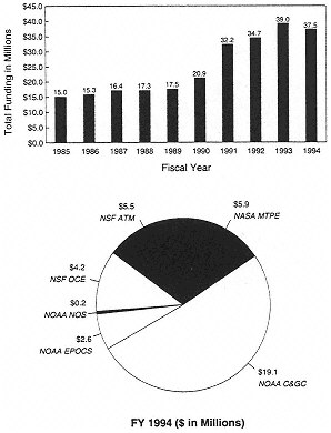
Figure 4. Funding for U.S. TOGA. The bar chart shows total funding, by year, for U.S. efforts contributing to the TOGA Program. The pie chart shows U.S. funding, by program, for the last year of TOGA. See the text for descriptions of activities that were included or excluded from the totals, and for the program abbreviations. (Data courtesy of M. Patterson, NOAA.)
TOGA. For example, no costs of satellite-based instruments are included in the totals given above and in the figure. However, TOGA made use of operational meteorological satellites operated by NOAA (National Oceanic and Atmospheric Administration) and research satellites operated by NASA (National Aeronautics and Space Administration) for multiple scientific purposes. The totals for TOGA do not include most of the international meteorological observing system on which TOGA relied, but do include the specialized observing system that was deployed as part of TOGA in the tropical Pacific. The TOGA Program also benefited from work by the National Weather Service to provide operational long-term outlooks and to develop numerical models for short-term climate variations, but those costs are not included.
Several U.S. federal agencies participated in TOGA. A breakdown of their contributions for the final year of the program is shown in the Figure 4 pie chart. A similar chart for 1989 can be found in NRC 1990, which also includes a discussion of the funding mechanisms for TOGA. The statistics on which these figures were based came from an annual survey conducted by the U.S. TOGA Project Office. Funding levels include only resources requested and directed specifically for TOGA research. NOAA funding came from three offices: the NOAA Climate and Global Change Program (labeled C&GC, which includes its predecessor, the NOAA TOGA Program), the NOAA Equatorial Pacific Ocean Climate Studies (EPOCS) Program, and the National Ocean Service (NOS). National Science Foundation (NSF) funding came from the Ocean Sciences Division (OCE) and the Atmospheric Sciences Division (ATM). NASA funding came from the Mission to Planet Earth (MTPE) Program. The Office of Naval Research participated only during 1992–1993, for TOGA COARE, and is therefore not shown in the pie chart for the last year of the program. Participation by various agencies in specific field programs is noted below in this chapter.
OBSERVATIONS OF ENSO
The TOGA Observing System was initially designed to observe the evolving warm and cold phases of ENSO, and then provide the resulting data to scientists immediately. As predictions of the phases of ENSO began to show skill, priorities shifted to measuring those quantities most useful for initializing and evaluating coupled models. We now have the ability to measure the quantities of highest priority—sea surface temperature, surface winds, and subsurface thermal structure—plus some other quantities of interest.
If we were to stand on the equator with our backs to the coast of Ecuador and begin moving westward along the equator at walking speed—coincidentally, about the speed of the fastest ocean Rossby mode—it would take about nine months to reach the east coast of Halmahera Island in the far western Pacific. Over this vast expanse of ocean, only a few Volunteer Observing Ship (VOS) lines were in place throughout the 1960s and 1970s (see Figure 1 of Rasmusson and Carpenter 1982). VOS lines are series of observations of temperature, humidity, winds, cloudiness, and upper-ocean conditions made on a voluntary basis by the crews of non-research ships while the ships are traversing their normal routes. These limited observing resources left vast regions of the equatorial Pacific, almost as wide as the entire equatorial Atlantic, unmeasured. The problem for observing ENSO was to measure enough of the tropical Pacific, both at the surface and at depth, and to do it frequently enough to resolve the evolving atmospheric winds and ocean thermal structure.
At the beginning of TOGA (see Figure 5, top), there was no obvious solution to this problem. It was envisioned in the original TOGA Plan (sections 2.1 and 2.2 of NRC 1983) that the VOS observations would be augmented by a small number of drifting thermistor chains and fixed moorings, by additions to the upper-air network of the World Weather Watch, and by satellite measurements. As explained below, the original concept of the TOGA Observing System proved inadequate, and more creative and extensive means had to be developed. During the TOGA years, additional systems were put into place to reach the goals of TOGA. By the middle of the program's life, the TOGA Observing System looked as shown in Figure 5, middle, and by the last half of 1994, the TOGA Observing System looked as shown in Figure 5, bottom.
In addition to the need to observe regions previously under-observed, there was also a need to arrange for the prompt transmission of observational data to scientists (transmission “in real time”). This requirement necessitated changes to oceanographic instruments, such as moorings that recorded data on tape but did not transmit them, as well as changes in the practices of oceanographers. The scientists involved in TOGA made enormous progress in the development of observing systems that provided data in real time.
TOGA Observing System
The TOGA Observing System is a primary legacy of the TOGA Program. The following discussion touches on the broad range of observations used to address the scientific objectives of TOGA. Some of these observations were not established by TOGA, but were used, championed, or sustained by scientists participating in TOGA. As noted above, the TOGA Observing System was initially designed to observe ENSO. As such, it concentrated on the tropical oceans,
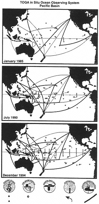
Figure 5 (at left). The TOGA In Situ Pacific Basin Ocean Observing System. The top panel is as of the start of TOGA in January 1985, the middle panel as of 1990, and the bottom panel as of the end of TOGA in December 1994. Moored buoys with thermistor chains and wind-measuring equipment are shown with diamonds, and those with current meters added are shown with squares. Island and coastal tide gauges that reported to the TOGA Sea Level Center are shown with circles. Drifting buoys are indicated schematically with short arrows; each arrow represents ten actual drifters. Tracks of volunteer observing ships releasing expendable bathythermographs are indicated by long curved lines, thick lines representing 11 or more transects per year and thin lines representing 6–10 transects per year. By the end of TOGA, most measurements were being reported in real time via satellite data relays. (Courtesy of M. McPhaden, NOAA/PMEL.)
especially the Pacific. A review of the TOGA Observing System was also presented in NRC 1994a. Building on the sparse operational network in place at the beginning of the program, TOGA built a diverse system incorporating observations that were:
-
meteorological and oceanographic,
-
land-based and ocean-based,
-
remotely sensed (mostly from space) and in situ,
-
funded by operational agencies and by research programs,
-
driven by predictive model requirements and by curiosity-driven desires for elucidation of physical mechanisms in the climate system,
-
obtained by standard means and by novel technologies, and
-
solutions to TOGA data needs and to the data needs of other scientific and operational constituencies.
The scope of the system was broader than the idealized (and not as yet established) observing system envisioned by TOGA Objective #3: “… an observing and data-transmission system for operational prediction.…” Such a system, tuned to provide just the data required for “operational prediction”—not more, not less—remains an ideal. A method for optimizing the observing system, using clear results from accepted prediction models, is still in development. It is likely that this ideal system will include a number of substantial enhancements and augmentations of the present-day system, and perhaps some selective winnowing of observations that do not carry much information into the prediction process in proportion to their cost. A limit on any such winnowing is that while some particular measurement series may prove to be of marginal utility for TOGA purposes, the data time series may be of great value for some other set of scientific studies or operations, and those other constituencies should be included in discussions about the future modification of the observing system.
Table 1. TOGA data requirements
|
|
Quantity |
Spatial Resolution |
Temporal Resolution |
Accuracy |
|
1 |
Upper-air winds |
500 km (900 mb, 200 mb) |
1 day |
3 m/sec |
|
2 |
Tropical wind profiles |
2500 km (every 100 mb) |
1 day |
3 m/sec |
|
3 |
Surface pressure |
1200 km |
1 day |
1 mb |
|
4 |
Total-column precipitable water |
500 km |
1 day |
0.5 g/cm2 |
|
5 |
Area-averaged total precipitation |
2° latitude by 10° longitude |
5 days |
1 cm |
|
6 |
Global sea surface temperature |
2° latitude by 2° longitude |
30 days |
0.5 K |
|
7 |
Tropical sea surface temperature |
1° latitude by 1° longitude |
15 days |
0.3–0.5 K |
|
8 |
Tropical surface wind (1) |
2° latitude by 10° longitude |
30 days |
0.5 m/sec |
|
9 |
Tropical surface-wind stress (1) |
2° latitude by 10° longitude |
30 days |
0.01 Pa |
|
10 |
Surface net radiation |
2° latitude by 10° longitude |
30 days |
10 W/m2 |
|
11 |
Surface humidity |
2° latitude by 10° longitude |
30 days |
0.5 g/kg |
|
12 |
Surface air temperature |
2° latitude by 10° longitude |
30 days |
0.5 K |
|
13 |
Tropical sea level |
(2) |
1 day |
2 cm |
|
14 |
Tropical ocean subsurface temperature and salinity |
(3) |
(3) |
(3) |
|
15 |
Tropical ocean surface salinity |
2° latitude by 10° longitude |
30 days |
0.03 PSU |
|
16 |
Tropical ocean surface circulation |
2° latitude by 10° longitude |
30 days |
0.1 m/sec |
|
17 |
Sub-surface equatorial currents |
30° longitude (at 5 levels) |
as available |
0.1 m/sec |
|
(1) While the accuracy values are given for 30-day averages, daily values are required for the resolution of 30–60 day oscillations. (2) Resolution as permitted by available sites and satellite altimetry. (3) See discussion in chapter 3 of NRC 1994a. |
||||
A good overview of TOGA requirements for observations and the methods that were used to meet some of those requirements can be found in sections 2–7 of the International TOGA Implementation Plan (fourth edition, International TOGA Project Office 1992). Table 1, extracted from that plan, shows the atmospheric and oceanographic quantities desired, with associated sampling intervals and accuracies in both space and time. The Implementation Plan also provides brief rationales for the numbers presented. Mostly, the accuracies and sampling requirements are based on observed amplitudes of ENSO signals in the ocean and atmosphere. Prediction models and observing-system simulation experiments (OSSEs) are not yet able to reliably guide the design of complete observing systems.
Sections 3–7 of the Implementation Plan summarize well the current status and near-term outlook for upper-air instruments, moorings, drifters, VOS, and island tide gauges, respectively. These were the principal tools of the TOGA Observing System for in situ measurements. Their condition at the end of 1994 is the TOGA legacy for observations insofar as TOGA played a role in creating or sustaining them. A particular measurement platform usually contributed to measurements of more than one quantity of interest. For example, the TOGA TAO moored array provides data on surface winds, surface-air temperature, sea surface temperature, surface atmospheric pressure, and upper-ocean thermal structure, with additional data on upper ocean currents at some of the array elements. Space-based observations were generally not designed specifically by or for the TOGA community, yet they have proven crucial for measuring certain basic quantities of the ocean and atmosphere, and will therefore be discussed as part of the system.
To explain how and why the TOGA Observing System developed as it did, we provide a history of the observing system with an emphasis on the overall motivation and on the scientific and technical problems that arose at crucial stages along the way. It begins with a discussion of how traditional types of oceanographic measurement platforms were developed to address the problems of TOGA. By the time TOGA ended, a variety of options were available to measure what were, by then, agreed-upon quantities of highest priority. A final section indicates how, and how well, these high-priority quantities were measured.
Volunteer Observing Ships
Merchant ships, recruited under the auspices of the World Weather Watch to take standard surface observations for meteorological purposes, have been the major source of surface data over the open oceans for many years, and undoubtedly will continue to be for some time. TOGA heightened our awareness of both the utility and drawbacks of volunteer observing ships (VOS) as a data
source. It also advocated the continuation of VOS measurements and pointed out ways in which they could be improved and enhanced. Participants in TOGA championed, with some success, the identification of additional VOS candidates in data-poor tropical regions, improvement in the promptness and reliability of data communication using conventional high-frequency radio or newer links (e.g., communication satellites), the aggressive recovery of additional data for archiving from platforms such as fishing vessels that do not provide immediate data transmission, the upgrading of the accuracy of shipboard instruments and methods, and the development of hull-contact sensors for ocean measurements (thereby easing installation and calibration problems). Modernizing and bringing such a far-flung system to maximum effectiveness is not a one-shot process; continual pressure has been and will be required.
A particularly effective “add-on” to basic VOS surface observations has been the inclusion of regular expendable bathythermograph (XBT) observations of upper-ocean thermal structure to the routine of selected VOS that traverse scientifically critical routes. Much of this work has been planned and carried out in concert with the World Ocean Circulation Experiment (WOCE) because a given ship often crosses regions of significance to both programs. A joint TOGA and WOCE set of route charts and sampling-interval suggestions was produced. Not all the recommended routes were sampled, and even fewer were sampled as frequently as TOGA objectives required, but there has been progress in recent years. While the accumulated VOS reports are of great value in our knowledge of the background state and climatology of the ocean, the tracks are too wide apart in the tropics and visited too infrequently to permit the study of the evolving warm and cold states characteristic of ENSO (see the figure on p. 30 of NRC 1994a).
Surface Drifters
Lagrangian drifters closely follow the ocean currents in which they sit. They are an effective means of obtaining broad, basin-wide coverage of sea surface temperature, sea-level pressure, and near-surface currents. In the late 1970s, Doppler-ranging from the French navigational system ARGOS became operational on NOAA TIROS (Television Infrared Observation Satellite). It was a cost-effective technique for listening to and locating radio transmitters on the ocean surface. The development of TIROS spawned the design and construction of a large number of ocean-surface drifters for measuring ocean circulation and as platforms for a variety of meteorological sensors.
The drifters designed in the 1970s typically used large surface floats and “window-shade” drogues, a combination that degraded their ability to follow surface currents accurately and limited their useful lifetimes. During the planning of the World Climate Research Programme (WCRP 1983) several re
searchers realized that a redesigned drifter, one that was lightweight, long-lived, and readily deployable from ships, could make widespread measurements of sea surface temperature, surface pressure, and surface velocity to accuracies of ±0.3 K, ±1 mb, and ±1 cm/sec, respectively. By 1985, Draper Laboratory of the Massachusetts Institute of Technology, NOAA's Atlantic Oceanographic and Meteorological Laboratory (AOML) and the Scripps Institution of Oceanography (SIO) had produced competing drifter designs. During the period 1985–1989, field measurements of the water-following capability of the drifters were made using vector-measuring current meters (VMCMs) attached to the top and bottom of the drogue attached to the drifter (Niiler et al. 1987, Niiler et al. 1994). Several modeling studies of drifter behavior in steady upper-layer shear and linear wave fields were also carried out (Chereskin et al. 1989). These studies provided a basis for interpreting possible differences between the movement of the drifter and the movement of the water.
In 1978, under the auspices of the NOAA/EPOCS program, the deployment of small groups of drifters began in the tropical Pacific (Hansen and Paul 1984). Under the auspices of TOGA in 1988, a basin-wide process experiment, the Pan-Pacific Surface Current Study, began. Its technical objectives were, over a three-year period, to learn to use VOS to maintain a group of 160 drifters and to select the most robust elements from the competing drifter designs. Its scientific objectives were to obtain a basin-wide field of surface currents and sea surface temperature of the tropical Pacific for the purpose of studying processes that determine the evolution of sea surface temperature. By 1991, these objectives had been realized and a WOCE/TOGA Lagrangian Drifter design was published (Sybrandy and Niiler 1991). These new drifters had a half-life of over 400 days at sea. They were deployed routinely, with over 95 percent survival, from VOS by a single able-bodied seaman. Costs for tracking and communication were reduced to one-third of the costs incurred using the older design, with no reduction of data quality. New sensors were also developed. Barometers were added to the drifters in 1991. In 1992, new salinity sensors were deployed during TOGA/COARE.
At the end of 1994, there were nearly 500 drifters, deployed from VOS or aircraft, in the global ocean. The greater portion of these drifters reported data through the Global Telecommunication System (GTS) to operational meteorological and oceanographic centers. The data from these drifters were processed at the Drifter Data Center (housed at NOAA/AOML), and are available over the Internet using anonymous ftp (file-transfer protocol) with about a one-month delay. Fourteen countries contribute resources to this drifter program, and seven U.S.-government agencies use the WOCE/TOGA Lagrangian Drifter as an operational instrument.
The Global Drifter Program in support of climate research and monitoring is now in place. It is an element of both the Global Ocean Observing System (GOOS) and the Global Climate Observing System (GCOS). TOGA played the principal role in the inception and implementation of this drifter program. Of primary interest to TOGA were sea surface temperature data from drifters. These data are critical because they provide well-distributed benchmarks for adjusting and correcting the inaccuracies and biases in maps of sea surface temperature derived from other sensors (such as those on satellites or VOS). Of great interest in oceanography, but of somewhat less importance to ENSO predictions, is the ability of drifters to determine accurately, with minimal contamination from wind and other noise, large-scale patterns of the surface currents. Drifters are being constructed in and deployed by several nations, using both research and operational funding. A census of 250 units in the tropical Pacific was stated as a goal for TOGA, and at the end of 1994 was approximately met. An additional set of 50 meteorological drifters (compared with a stated requirement for TOGA of 100) in the southern oceans was sustained primarily to obtain surface meteorological data, especially sea level pressure, in this data-sparse region. These drifters, the so-called FGGE (pronounced “figgy”, after the First GARP Global Experiment) buoys, have a different hull form, so their displacements are less useful than the new Lagrangian drifters for mapping surface currents.
Tide-Gauge Network.
Tide gauges measuring sea-level changes have been maintained for many years in harbors and lagoons of Pacific islands. Some of these gauges date back to shortly after World War II. In 1972, NOAA shut down the upper-air and sea-level stations at Canton Island and Christmas Island, right at the beginning of the NORPAX program. This action was taken as the 1972–73 El Niño was beginning, creating an unfortunate break in critical time series that were more than 20 years long. Jacob Bjerknes, who had used the long time series from Canton Island in his research on ENSO, wrote a protest letter to NOAA in hopes that this key station would be maintained. His letter fell on deaf ears. Such was the lack of appreciation for climate monitoring at that time.
Klaus Wyrtki of the University of Hawaii, whose research using sea level made the case for the importance of ocean dynamics in climate (Wyrtki 1973), immediately went to work to rebuild the sea-level network of Pacific islands to ensure long time series for future climate research. He proposed a sea-level monitoring network for climate-research purposes. NSF funded the proposed network under the NORPAX program, and Wyrtki began installing tide gauges on various islands. In addition, Wyrtki expanded this network by forging relationships with numerous other Pacific nations that maintained tide gauges
for their own purposes. The science that emerged from the sea-level measuring effort was an important part of the foundation upon which TOGA was built.
The newly established tide-gauge network monitored the large water-mass displacements during the 1976 and 1982–83 ENSO warm events, leading to the discovery of the very large horizontal scales of sea-level variability associated with these events (Wyrtki 1979, Firing et al. 1983). The original grant for Wyrtki's efforts was renewed for ten years under the International Decade for Ocean Exploration. Starting in 1982, support of the tide-gauge network was provided jointly by NSF, NASA, and NOAA under new funding for the upcoming TOGA program. In 1990, NOAA took over responsibility for funding the Pacific Sea Level Network. Expansion of the sea-level network into the Indian Ocean began in 1986. As of the end of 1994, 115 stations were transmitting data regularly; 79 were in the Pacific, 24 were in the Indian, and 12 were in the Atlantic. Of the total, 68 reported in real time. In the Pacific, almost all of the islands that might host gauges now have them; some islands present logistical problems that make it almost impossible to maintain a tide gauge. At the close of TOGA, the network was still being expanded in the Indian and Atlantic Oceans; the most recent addition was five tide gauges deployed by France in the tropical Atlantic. Satellite telemetry of the measurements has become easier; its further use can only enhance the value of the sea-level data for such purposes as near-real-time inclusion in operational ocean-circulation models.
The TOGA Sea Level Center (TSLC) was created in 1985. It was charged with collecting data from all data originators within the global tropics, processing and quality-controlling these data, and distributing them within eighteen months of collection. Originally, only daily-mean sea-level values were to be disseminated, but it soon became apparent that hourly data were required for adequate quality control and for resolving the physical quantities of interest. Also, monthly-mean products were originally planned and provided. The TSLC now makes a provisional sea-level data set from selected stations available with only a one-month delay. The rapid provision of in situ data has proven to be an important supporting contribution to the success of the U.S./France TOPEX (Ocean Topography Experiment)/Poseidon altimetric sea-level satellite mission. As of July 1994, the TSLC archives contained 3424 station-years of data from 289 sites, with half of the data added during the previous two years having come from the Indian and Atlantic Oceans. The TOGA sea-level data from tide gauges has become one of the most frequently requested data sets.
TAO Array
The establishment of the Tropical Atmosphere/Ocean (TAO) moored array of instruments in the tropical Pacific (see Figure 5, bottom) was one of the crowning achievements of the TOGA program. The array measures those quantities
of highest priority for understanding and predicting ENSO. Its deployment was a great technical achievement. However, the basin-wide TAO array was not completed until very late in the TOGA program. It was conceived because all other existing means for real-time monitoring of the Pacific, whether in situ or remote, had proved inadequate to fulfilling the goals of TOGA.
Early in the planning for TOGA, it was recognized that the existing and planned XBT lines from the VOS program would not provide sufficient spatial and temporal coverage for determining the upper-ocean thermal structure as specified in the scientific plan for TOGA (NRC 1983). There were large gaps between some of the ship tracks, and temporal sampling in the equatorial region was inadequate. In order to address these problems, the earliest versions of the TOGA Implementation Plan called for the deployment of drifting thermistor chains, which would measure the temperature profile of the upper ocean. It was believed that the drag over the length of the chain would prevent rapid movement through the areas where the data were needed, and that chains could be easily launched from VOS. Efforts by NOAA's Pacific Marine Environmental Laboratory (PMEL) and SIO resulted in the deployment of several such drifters, but they did not work well. In particular, the commercial manufacturer chosen could not solve quality-control problems. (A French version of this device worked well in the Indian Ocean and during TOGA COARE.)
The ATLAS thermistor-chain mooring (described in detail below) was developed during the early 1980s, with support from the NOAA/EPOCS program, in parallel with the efforts to develop drifting thermistor chains. However, it was not until late in 1986, when the drifting thermistor chains were abandoned, that new plans were made to put a limited number of TAO moorings out along three longitudes. As the ATLAS mooring system demonstrated its usefulness, an ambitious plan was developed to expand the TAO array to cover the entire Pacific wave guide. This expanded array was expected to provide sufficient simultaneous wind and thermal-structure information to allow determination of the nature of the inadequacies in ocean models. (These inadequacies had been attributed to both poor specification of the wind forcing and to incorrect model physics.)
The development of the TAO array rested on earlier efforts for making unattended measurements in the open ocean. In the 1970s, NOAA/PMEL, the P.P. Shirshov Institute of Oceanology, and Woods Hole Oceanographic Institution all experimented with techniques for recording time series of upper-ocean current and temperature measurements using a surface buoy anchored to the bottom at depths of 4–5 km. All faced difficulties in deploying and maintaining surface moorings because of stresses on the mooring line caused by the shears of strong currents in the upper ocean. For example, in the Pacific, the eastward Equatorial Undercurrent, which has a maximum speed of 1m/s at 100m depth,
flows beneath the westward South Equatorial Current, which has a maximum speed of 1 m/s at the surface. The accuracy of wind measurements from a moored surface-following float (Halpern 1987a) and the accuracy of upper-ocean current measurements beneath such a float (Halpern 1987b) were acceptable for studies of the equatorial ocean.
The first collection of moored surface buoys to span the equatorial Pacific was established in 1979 during the Global Weather Experiment. From these buoys, simultaneous measurements were recorded of upper-ocean temperatures and currents along the equator at 165°E, 152°W and 110°W (Halpern 1980). Analyses of these observations demonstrated the need for long-term measurements of upper-ocean temperature and current fields as well as the feasibility of making reliable surface meteorological and upper-ocean observations for long periods. Theoretical ideas (McCreary 1976) about wind-generated downwelling equatorial Kelvin waves propagating 10000 km from the western Pacific to South America were confirmed by measurements from these moorings (Knox and Halpern 1982, Eriksen et al. 1983) and led to conceptual models for detecting the onset and termination phases of El Niño.
In the early 1980s, NOAA's EPOCS program initiated long-term surface-meteorological and upper-ocean current and temperature measurements on the equator using moored platforms. These measurements were designed to determine the annual cycles of the depth of the thermocline and the strength of the Equatorial Undercurrent (Halpern 1987c, Halpern and Weisberg 1989), to monitor the occurrence of Kelvin waves, and to validate the first generation of ocean general-circulation models for the tropical Pacific based on the primitive equations (Philander and Seigel 1985). Deepening of the thermocline, disappearance of the Equatorial Undercurrent, and appearance of the warm El Niño current running eastward along the equator—all features of the 1982–83 El Niño—were observed along the equator for the first time during an El Niño (Firing et al. 1983, Halpern et al. 1983, Halpern 1987c). As a result of these measurements, moored buoys were recognized as an essential feature of a longterm monitoring system for prediction and description of El Niño.
The undetected onset of the 1982–83 El Niño episode motivated real-time monitoring (Halpern 1996) of equatorial moored-buoy measurements. At the beginning of TOGA, moorings for making surface-meteorological and upper-ocean observations were established along the equator at 140°W, 125°W, and 110°W (Halpern 1988, Halpern et al. 1988). A fourth mooring was deployed at 165°E shortly thereafter. However, wind measurements at three or four sites in the equatorial Pacific were not sufficient to describe the surface wind field in the region extending from approximately 5°S to 5°N, where knowledge of surface winds is critically important for forecasting variations of the equatorial upper-ocean thermal and flow fields (McCreary 1976). Because the launch of a
satellite-borne instrument for estimating vectors of equatorial Pacific surface winds was delayed for seven years, making it unavailable for TOGA, and because the idea of drifting thermistor chains did not seem feasible, an array of moored wind and subsurface measurements (Hayes et al. 1991), the TAO array, was contemplated.
The TAO array was not designed casually. Its design grew out of the need to observe the development of phases of ENSO in real time and to validate the forcing and responses of equatorial ocean models. The array was based on the developing knowledge of the scales of variability of the wind field and the effects of the wind field on the thermal structure of the upper ocean.
The first analysis of the sampling and accuracy requirements for tropical wind measurements was performed during the SEQUAL/FOCAL (Seasonal Equatorial Atlantic Experiment / Francais Océan Climate Atlantique Equatorial) program in the Atlantic and published in the program plan for the SEQUAL Wind Program (SEQUAL 1982). Using the theoretical results of Cane and Sarachik (1978) for forced linear motion and assuming a random noise in the wind forcing, it was shown that monthly-mean wind stress needed to be known to about 0.1 Nm-2 over 500 km regions for dynamical models to reproduce thermocline displacements of 5 m. This simple result illustrated the crucial importance of accurate wind-stress information in the equatorial wave guide for quantitative tropical oceanography. It also prompted examination of the available data sets of surface winds and the resulting estimates of surface wind stress.
Soon after the SEQUAL/FOCAL efforts, plans were made for the Pacific Equatorial Dynamics (PEQUOD) experiment to study a number of different tropical phenomena. Wyrtki and Meyers (1975) had earlier published a climatology of surface winds that revealed the very large data voids typical of the historical data set for the Pacific region. There was strong variability between bimonthly periods and considerable noise in the individual vectors, which suggested that the atmosphere was strongly variable on these (or shorter) scales and that the sampling was not sufficient to resolve this variability. It became clear that obtaining an accurate wind field was necessary if models were to be used either for modeling tropical Pacific variability or as the basis for data-assimilation methods to help interpret observations. However, better information on the variability of surface winds in the tropics was needed to determine the appropriate scales and sampling strategies.
A study of 30 years of data from tropical Pacific islands collected by the New Zealand Meteorological Service was undertaken to determine therelevant spatial and temporal scales of variations in the surface winds. Luther and Harrison (1984) presented preliminary results comparing powerspectra in the frequency domain. The spectra were based on the completetime series of monthly means as well as on time series of monthly meansconstructed from
random sub-samples of the full time series. Luther and Harrison then compared their island-based results with the ship-based spectral results of Goldenberg and O'Brien (1981). The comparison suggested that away from the annual frequency, the ship observations were heavily aliased by unresolved high-frequency variability, and that about 30 observations per month were needed to resolve the dominant energetic scales of tropical wind variability. Analysis of the spatial coherence suggested that the coherence scales for the energetic frequency bands were about 2–3 degrees in latitude and 15 degrees in longitude. Harrison (1989) examined the effects of having limited zonal and meridional wind data in simulations of sea surface temperature during ENSO. This model study indicated that, within the model assumptions, it was necessary to know the wind stress all along the equatorial wave guide and within about 7 degrees of latitude of the equator for simulations of sea surface temperature to be accurate within about 0.5°C.
Stanley Hayes proposed the current configuration of the TOGA TAO array (Hayes et al. 1991). He based the design on the above-mentioned observational results of the coherence properties of the island winds and on the modeling results of the accuracy of the winds needed to accurately simulate the sea surface temperature. The planned array would span the equatorial wave guide, from 8°S to 8°N, and extend from the eastern Pacific all the way to the western Pacific. Although the instruments also measured surface temperature and subsurface thermal structure, the spacing and sampling design was based on the wind variability because so little was known about the spatial scales of temperature variability.
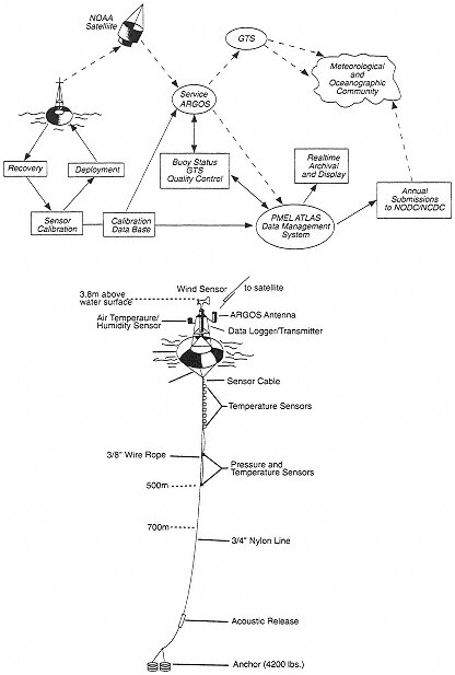
The typical TAO mooring, illustrated in Figure 6, is an ATLAS (Autonomous Temperature Line Acquisition System) mooring. It provides (via Service ARGOS) data on surface wind, sea surface temperature, surface air temperature, humidity, and subsurface temperatures at 10 levels down to 500 m. The toroidal buoy at the surface holds the atmospheric instruments and the satellite transmitter, while the line anchored to the bottom holds the thermistors and pressure devices that transmit their readings up the line. To save battery power, a certain amount of on-board processing is done, so that only hourly averages are transmitted. A tape keeps data with full temporal resolution. This tape is recovered when the buoy is removed and its replacement deployed, typically every six months. Also part of the TAO array are five equatorial stations that provide data on ocean currents. These moorings use a downward-looking acoustic Doppler current profiler (ADCP) to obtain measurements from the surface down to 250 m depth.
Implementation of the TAO array in the tropical Pacific did not begin until 1986, because the idea of a large TAO array was conceived only when it became clear that a satellite-based scatterometer for measuring surface winds
would not be available for most of the duration of the TOGA Program. The array grew slowly. Gradual engineering improvements eventually allowed a predictable mooring lifetime of about six months. However, limitations of budgets and ship time, and the need for international cooperation, all delayed the completion of the planned array of moorings until very near the formal end of the program. The full complement of about 70 moorings was not completed until the end of 1994, as the TOGA Program ended. The growth of the array was aided by various process studies. Initially, moorings were deployed for EPOCS. Towards the end of the TOGA decade, moorings were deployed as part of the international COARE experiment, which required moorings in the western Pacific. Some western Pacific nations assisted in the deployment of these moorings.
The history of the TAO array provides a lesson in the interaction of process studies with monitoring networks. Many of the quantities now measured by the TAO array were originally expected to be measured by satellite. However, the TAO array was a necessary and creative response when the proposed satellite systems failed to materialize on schedule. Not only is the TAO system cheaper and better adapted to TOGA problems, but it also provides data on subsurface thermal structure, which could not be obtained directly (though some information can be inferred) from satellites.
The foundation for TOGA moored measurements was provided by the research community with research funding. Only now, with the end of TOGA, is this research observing system beginning its transition to a monitoring system in support of short-term climate predictions. Maintenance and operation of the array involve significant costs for ship time and communications, in addition to the costs of the mooring hardware. Mooring failures, data transmission problems and dropouts, mooring vandalism (especially in the western Pacific where the moorings are set in heavily fished areas), and the availability of ship resources to deploy and maintain the moorings are all continuing problems. Although moorings are inexpensive in comparison to spacecraft and satellites, a typical oceanographic vessel suitable for maintaining the TAO array costs $4–5 million per year. Securing reliable and sufficient international commitments of ship time—perhaps 1–2 ship-years per year—to sustain the array will require continued effort and attention in the years ahead. The TAO array is generally agreed to be the observational element that is most critical to sustain into the post-TOGA era, for two key reasons. First, it measures the high-priority fields (sea surface temperature, surface winds, and upper-ocean thermal structure) in otherwise inaccessible locations, relatively economically. Second, the TAO array has reached full deployment only recently, so there has not yet been time to make a careful assessment of its impact on predictions, particularly predictions of ENSO phenomena (NRC 1994a). Extensions of this type of observing
system into higher latitudes, or into the Indian and/or Atlantic Oceans, while clearly desirable for predicting short-term climate variations, will require detailed study, justification, and funding.
Satellite Observations
No satellite sensor or spacecraft platform can be considered to be an accomplishment of the U.S. TOGA Program, although TOGA did drive improvements in some systems and their use. This is in contrast to the in situ observing platforms that form the basis for the TOGA Observing System. Notwithstanding this difference, remotely sensed observations of the coupled ocean-atmosphere system played a key role in the development and evolution of the TOGA Program. For example, composite pictures of cloudiness from the satellites ESSA-3 and ESSA-5 were used by Bjerknes (1969), to formulate the hypothesis that ENSO resulted from a coupling of oceanic and atmospheric circulations.
In the early 1980s, a NASA working group was charged with identifying areas of ocean science that would experience significant advancement as a result of remotely sensed measurements of the surface wind field. That group singled out studies of the El Niño phenomenon as the major beneficiary (O'Brien et al. 1982). At the outset of TOGA, the proposed 1990 launch of a NASA scatterometer (NSCAT) on board the U.S. Navy Remote Ocean Sensing System (NROSS) satellite was expected to provide data on winds at the sea surface. It was anticipated that these data would have a dramatic impact on modeling and assimilation studies during the second half of TOGA. To the dismay of many in the TOGA community, the NROSS mission was canceled, and NSCAT was not launched until August 1996 on board the Japanese Advanced Earth Observing Satellite (ADEOS). The lack of comprehensive satellite coverage of the equatorial Pacific surface-wind field played a major part in the justification and deployment of the TAO array.
Limited observations of the surface-wind field became available in 1978 from Seasat and from Nimbus SMMR (Scanning Multichannel Microwave Radiometer). Wind-speed estimates from the passive microwave sensor on board the Defense Meteorological Satellite Program (DMSP) SSM/I (Special Sensor Microwave/Imager) satellite became routine in 1987 (Wentz 1989). Global coverage with 35 km resolution is now provided approximately every 1.5 days by the two satellites in orbit as part of this operational series. Various techniques have been proposed to convert this wind-speed information into wind velocity (e.g., Atlas et al. 1991, Wentz 1992). Examination of these wind fields for the tropical Pacific Ocean indicates that they are comparable to existing operational and subjectively derived wind fields (Busalacchi et al. 1993) and direct wind-speed measurements from the TAO array. Remotely sensed observations of the surface-wind velocity field began in July 1991, when the
European ERS-1 (Earth Resources Satellite) was launched with a radar scatterometer on board. The processing of these data has since undergone a number of refinements (Stoffelen and Anderson 1992, Freilich and Dunbar 1993).
The launch of the U.S. Navy's Geosat in 1985 made possible the use of satellite altimetric measurements to obtain near-global sea-level coverage. When the Geosat data were declassified in 1986, they increased, rather than reduced, the value of the in situ sea-level observations. Combined, the two data sources provided a unique view of equatorial wave processes that had been sparsely observed by the in situ network. With the launch of TOPEX/Poseidon in 1992, in situ data revealed the high accuracy of the space-based measurements, and gave confidence to their interpretation. The interpretation of the long time series of in situ data can also be enhanced using the spatial coverage provided by the satellite.
During the course of TOGA, remote measurements of a number of quantities—e.g., sea surface temperature, sea level, water vapor, and cloud fraction—were obtained from both research and operational satellites. Unfortunately, the TOGA Program ended prior to rigorous assessment of the ultimate value to ENSO monitoring and prediction of many of the remotely sensed quantities. It is left to the emerging GOALS Program to accomplish this assessment.
Observing the Atmosphere and Ocean for TOGA
TOGA scientists recognized early, on the basis first of the work of Bjerknes (1969) and later of the work of Zebiak and Cane (1987), that ENSO was a coupled atmosphere-ocean phenomenon. The prime quantities of observational interest were sea surface temperature, surface wind velocity, and upper-ocean thermal structure. The identification of these prime quantities enabled TOGA to set its priorities clearly and unambiguously. Other quantities, such as sea surface salinity, surface heat fluxes, and sea-level height, were all of interest but of a lower priority.
Sea Surface Temperature
Sea surface temperature is the prime oceanic quantity to which the atmosphere in the tropics responds. Sea surface temperature is measured in situ by the TAO array, the VOS network, and the Global Drifter Array. A great challenge has been to use these relatively sparse (except perhaps close to the equator) measurements to make gridded global fields of sea surface temperature. A combination of remote and in situ data has proved to be the solution.
The definition of sea surface temperature also presents problems. Ships and buoys vary in the exact depth, water volume, and averaging time used when measuring “bulk” in situ sea surface temperatures. These variations in tech
nique have made it very difficult to create long-term homogenous time series. Satellite measurements integrate over a large area but see only the “skin temperature” from a layer less than 10-4m in thickness. Skin temperature can often be a few tenths of a kelvin less than bulk temperature. Under low-wind conditions during TOGA COARE, skin temperature was observed to be as much as 4 K higher than the bulk temperature.
The large-scale monitoring of sea surface temperature using infrared satellite measurements from the operational AVHRR provided a critical contribution throughout the entire TOGA Program. These measurements were the principal source of information going into the sea surface temperature indices that were used to validate coupled atmosphere-ocean prediction models. They served as the basis for the fields of sea surface temperature used to force simulations with atmospheric general-circulation models, and to evaluate simulations with ocean general-circulation models. However, transformation of satellite measurements of radiances into sea surface temperature is not straightforward, because of calibration biases and contamination from clouds and atmospheric aerosols, such as those from volcanic eruptions.
In view of the limitations of both satellite and in situ data, TOGA investigators made extensive use of blended analyses of sea surface temperature produced by the U.S. Climate Analysis Center (CAC, now the Climate Prediction Center, CPC). In these analyses, the biases of the AVHRR data were reduced in an objective manner by including measurements of sea surface temperature from the Global Drifter Array and VOS surface observations. Towards the end of TOGA, a new optimal interpolation scheme that improved on this blended product was developed at the National Meteorological Center (NMC, now the National Centers for Environmental Prediction, NCEP) (Reynolds and Smith 1994). At the end of TOGA, the CAC product was available weekly on a global 1°×1° grid. The root-mean-square error between this product and independent measurements of sea surface temperature from the TAO array was 0.3–0.7 K. The confidence placed in this product attests to the importance of combining the spatial coverage provided by satellite measurements with the high accuracy of in situ measurements.
Surface Wind and Stress
Wind stress at the surface of the equatorial ocean is the prime driver of oceanic dynamics and a crucial determinant of sea surface temperature. It therefore shared with sea surface temperature the highest observational priority in TOGA. The need for accurate wind-stress estimates has been known since equatorial ocean models became good enough for detailed comparisons with observations. The long time series of hand-analyzed tropical Pacific pseudo-stresses (1963 to date) produced at Florida State University has proven invaluable in running
ocean models, although inadequacies in these estimates of the wind fields have long been recognized (see, e.g., Halpern 1988, Legler 1991).
The main source of equatorial surface-wind observations was the TAO array and the VOS network, because of the sparseness of islands in the Pacific. Both of these sources of observations reported immediately so that the data were available to the operational weather prediction centers (especially the U.S. NMC and the European Centre for Medium Range Weather Forecasting (ECMWF)). Outside the equatorial region, the main sources of wind data are the VOS network and satellite-based scatterometers.
Comparison of scatterometer data with monthly-mean wind speeds from TOGA TAO array for 1992 yielded cross-correlations of approximately 0.8 and root-mean-square differences of 1.4 m/s. The implications of this result for long-term monitoring, and for evaluating the advantages and possible redundancies of the suite of wind information sources—such as passive microwave sensors, radar scatterometers, and the in situ measurements from the TOGA TAO array—have not yet been determined.
Subsurface Temperature.
Subsurface thermal structure determines the location of the thermocline and therefore the location of the water destined to interact with the surface. Knowledge of this thermal structure is crucial to all descriptions and predictions of sea surface temperature. The initialization of models for making ENSO predictions requires specification of the subsurface thermal structure because the ocean's evolution on seasonal-to-interannual time scales is controlled, in part, by the planetary waves evident in the thermal structure.
The VOS network and the TAO array supply the only regular observations of subsurface temperature. Only from the TAO array are gridded fields of subsurface temperature available immediately. Also, the VOS data are irregular in space and time, and contaminated by higher-frequency waves that cannot be eliminated with the use of a single measurement at each location. However, in regions without moorings, the VOS system is invaluable for providing subsurface temperatures.
Elements of the TAO array have been in place sufficiently long for the gradual development of climatologies of subsurface temperature. Figure 7 shows the climatology of currents and subsurface temperatures on the equator at 110°W. Long-time-scale phenomena contribute to the mean annual cycle. Therefore, to derive climatologies for comparison with the annual cycles simulated by coupled atmosphere-ocean models, long deployments of observing systems are needed. Measurements must also be dense in time because shorter time-scale phenomena can alias the results.
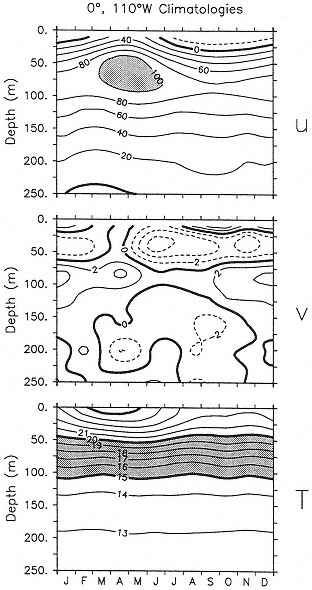
Figure 7. Climatology of the near-surface equatorial ocean at 110°W. Shown as a function of depth and month are (top panel) meridional velocity, u, in cm/s; (middle panel) zonal velocity, v, in cm/s; and (bottom panel) temperature in degrees Celsius. For u, dashed contours indicate westward flow, and for v, dashed contours indicate southward flow. (From McPhaden and McCarty 1992.)
Sea Level
Sea level can be an important tool in the study of heat budgets over large regions in the tropics because sea level is affected by changes in subsurface heat content. Wyrtki (1985) created an index of warm water in the equatorial Pacific for use in monitoring the development of El Niño. The global network of operational tide gauges provided valuable information on large-scale sea-level fluctuations for TOGA and other purposes. In the TOGA context, sea-level fields provide a tool for model validation and serve as a useful integral constraint for model initialization.
Sea-level differences can be interpreted in terms of the changing strength of ocean currents because the topography of the sea surface is linked by geostrophy with ocean circulation. This linkage was exploited by Wyrkti (1974, 1987) to examine equatorial currents in the Pacific. Sea level is a measure of other oceanographic quantities of interest as well, such as heat storage or thermocline depth. It is especially useful for estimating thermocline depth in the tropics, where the density structure can be approximated by a two-layer system (Rebert et al. 1985).
Sea level rises when the thermocline deepens and falls when the thermocline shoals. Therefore, it serves as a marker of the oceanic thermal structure. In the tropics, the interannual range of sea level is a few tens of centimeters. Tide gauges that are part of the TOGA Sea Level Network provide most of the measurements. It is difficult to obtain a picture of the evolving thermal structure of the Pacific from the Sea Level Network alone, because this network is limited to coastal stations and islands, and the islands are poorly distributed throughout the interior of the Pacific. Sea level estimates may be obtained by integrating the thermal structure of the ocean; it can thus serve as an integral constraint on numerical models of the ocean.
Measurements of sea surface topography from satellite altimeters were available from three different missions during TOGA—Geosat (1985–1989), ERS-1 (July 1991 onward), and TOPEX/Poseidon (August 1992 onward). As time progressed, the measurement accuracy of these satellite altimeters improved significantly. Globally averaged root-mean-square errors in determinations of both orbit radius and the corrected values of surface height dropped from approximately 30 cm and 8 cm respectively for Geosat, down to 20 cm and 6 cm for ERS-1, down to 4 cm and 3 cm for TOPEX/Poseidon. The errors are now sufficiently small that when the data are used to study the interannual variations of sea level in the tropical ocean (of order tens of centimeters) or the annual variability (of order centimeters), very little, if any, post-processing of the altimeter data is required.
Although the Geosat mission was originally intended for geodetic and mesoscale-oceanography applications of the U.S. Navy, the altimetric data proved surprisingly useful for monitoring equatorial-wave propagation, once large-scale orbit errors had been removed (Miller et al. 1988, Delcroix et al. 1991). The Geosat data have been used to track the space-time progression of a number of eastward-propagating Kelvin-wave pulses across the equatorial Pacific basin in response to westerly winds west of the dateline during the 1986–1987 ENSO warm phase (Miller et al. 1988, Cheney and Miller 1988). Beyond the tracking of propagating wave features, the meridional curvature (second spatial derivative) of the sea level across the equator has been used to infer changes in the zonal current field (Picaut et al. 1990). The resulting altimeter-derived estimates of the geostrophic flow field have been shown to agree well with the low-frequency, near-surface zonal current observed at the three TOGA current-meter moorings in the western, central, and eastern equatorial Pacific.
Prior to the launch of TOPEX/Poseidon, it was anticipated that the increased accuracy of the instruments on that three-to five-year mission, relative to that of previous altimeters, would be able to capture the sea-level evolution of a complete ENSO cycle. As it turned out, the timing of the launch in August 1992 coincided with middle of the protracted 1991–1992–1993 warm event. Comparisons of the first year of altimeter data from TOPEX with estimates of dynamic topography from more than 60 moorings of the TAO array indicate that the low-latitude sea-level variability in the Pacific for this period can be attributed primarily to equatorial Kelvin wave activity. These Kelvin waves appear to be generated west of the dateline by intense wind bursts that occur in association with the warm event (Busalacchi et al. 1994). Cross-correlations between data from the satellite altimeter and data from the moorings were generally greater than 0.7, with root-mean-square differences of approximately 4 cm. Comparisons of the satellite-altimeter data with sea-level data from approximately 70 island tide-gauge stations (primarily in the tropics) yielded similar results, with an average root-mean-square difference of 4.3 cm and a cross correlation of 0.66 for time scales greater than 10 days (Mitchum 1994).
A highlight of the TOPEX/Poseidon mission has been the use of altimetric data to track the sea-level signal of ENSO during 1992–1993 (CEES 1993). This success comes at a time when, as is the case with satellite scatterometry, the ultimate value of satellite altimetry for ENSO monitoring and prediction has yet to be determined. The next launch of a TOPEX-class altimeter is scheduled, with some uncertainty, to be NASA's Earth Observing System Altimeter mission in about 2000. A one-to two-year gap in sea-level monitoring with this class of altimeter is anticipated. At some future time, regular altimetric data
from satellites may relax the need, at least for studying ENSO, for a spatially dense tide-gauge network, such as the one developed in the Pacific.
Heat and Moisture Fluxes
Heat and moisture fluxes between the ocean surface and the atmosphere are a major influence on sea surface temperature. Throughout most of the tropics, the sensible heat flux from the ocean into the atmosphere is relatively small (on the order of 10 Wm-2) and relatively unchanging. The basic heat balance at the tropical sea surface is between the net radiation and the evaporation, with the heat flux into the ocean determined as the difference. The net heat flux into the ocean can be as large as 100 Wm-2 in the cold tongue of the eastern Pacific or as small as 10 Wm-2 in the Pacific warm pool. Evaporation is especially difficult to measure. It is often parameterized as a product of the wind speed and the difference in specific humidity between the surface air and 10 m up. The heat flux associated with latent heat of evaporation is generally known within only about 30 Wm-2 because of errors in measurement of both the winds and the specific humidities. Improved bulk-flux algorithms, especially for light-wind conditions, were developed by using direct measurements of evaporation taken during COARE (Fairall et al. 1996; Bradley and Weller 1995a, b).
Radiances measured from satellites have proven useful in deriving estimates of latent heat flux, radiative fluxes, and precipitation. Although data from satellites have been used to produce these flux fields, only limited validation of these fields in the tropics using in situ data has been performed. The measurements made during COARE are proving invaluable for calibrating satellite-based measurements.
Passive-microwave data can be used to estimate water-vapor distributions because the microwave spectrum is sensitive to the presence of water molecules. Using passive-microwave data, the relation of water vapor to sea surface temperature and convection during ENSO has been studied (Prabhakara et al. 1985, Liu 1986). Total-column water vapor, which can also be estimated from passive microwave data, has been used by Liu (1986) to derive an empirical formula for monthly-mean ocean-surface humidity. Combining this result with the passive-microwave estimates of the surface wind speed, Liu (1988) was able to estimate changes in the latent-heat flux over the tropical Pacific Ocean during the 1982–1983 warm phase of ENSO.
Additional approaches to deriving the fields of surface fluxes utilize atmospheric general-circulation models. One approach derives the fluxes from the operational global analyses performed at the various global weather-forecast centers. Another uses the output of an atmospheric general-circulation model forced by observed sea surface temperatures. In this latter approach, to the extent that the model is valid, the surface fluxes into the atmosphere (and
therefore the residual heat flux into the ocean) are known. While this method is difficult to validate (the COARE data set should be extremely useful in this regard), it offers a path to gradually improving our knowledge of the fluxes (see, for example, Weller and Anderson 1996). It can also be applied retrospectively as long as the sea surface temperature is sufficiently well known. Reanalysis of atmospheric data sets using atmospheric general-circulation models offers the possibility of preparing long time series of surface fluxes.
Upper-Air Observations
The distribution and availability of upper-air observations were a major concern during TOGA, and will continue to be a major concern for climate research. The overwhelming majority of upper-air observations derive from the Basic Synoptic Network (BSN) of the World Weather Watch (WWW). Some 400 BSN stations lie in the tropical belt (30°S-30°N), which was of primary interest to TOGA. TOGA identified 182 of these stations as having the highest priority because of the need for global coverage in the tropics and for data in areas where few other measurement platforms exist.
Unfortunately, few of these highest-priority stations report regularly and promptly (i.e., in real time via the Global Telecommunications System). Only those data that are transmitted promptly can be used in operational analyses and other products. Furthermore, the BSN has been deteriorating. The inadequacies of the WWW caused serious problems for TOGA. Successor efforts to understand and predict seasonal-to-interannual variations of the physical climate system will face similar problems. Solutions will have to involve a much broader constituency than just the climate research and prediction community, because the WWW is founded on concerns for operational weather forecasting and derives support from national budgets for this activity. Still, the climate community can lend its voice in support of this essential observing system.
Upper-air observations are also obtained using Doppler wind profilers (Gage et al. 1994), aircraft en-route reports (AIREPs), and estimates of winds made from cloud drifts shown in satellite images. Doppler profilers exist or are under construction at seven sites in the tropical Pacific, with two additional sites under consideration; all were developed as specific contributions for the TOGA program. Wind profilers can form a partial potential solution to the difficulties of maintaining manned BSN/WWW stations because they can operate unattended for long periods of time. Automation of the transmission of AIREPs, via Meteorological Data Collection and Reporting Systems (MDCRS) or similar techniques, could greatly enhance the receipt and usefulness of wind data from civil aircraft, which are usually of high quality. Winds estimated from cloud drift are an established and useful data set for studies of certain regions, includ
ing much of the tropics. These wind estimates can be made only as long as the geostationary satellites and the associated image-analysis effort are sustained.
Other Quantities
Measurements from the AVHRR, a satellite-based infrared imager, were used to study a number of attributes of ENSO in addition to sea surface temperature. Monthly anomalies of the outgoing long-wave radiation (OLR) observed by the AVHRR during TOGA proved to be an effective qualitative measure of tropical convection, and these measurements also served as a proxy for precipitation. These OLR estimates were used to monitor the extreme shifts in regions of strong convection during ENSO and the resulting surpluses or deficits, compared to normal conditions, in precipitation. More quantitative estimates of monthly precipitation totals are expected from the Global Precipitation Climatology Project (GPCP). Begun in 1987, this project is using infrared and passive microwave measurements to provide monthly mean estimates of precipitation with 2.5°×2.5° resolution over the entire globe for 1986–1995 (WMO 1990). A great leap in the quality of satellite-based precipitation estimation is expected with the launch of the Tropical Rainfall Measuring Mission in 1997. A suite of visible, infrared, passive-microwave, and active-microwave radiometers will be dedicated to measuring precipitation, and also the vertical profile of the latent heat released in the tropical atmosphere.
The AVHRR instrument and visible and infrared channels on a number of geostationary satellites are being used with sounding data from satellites to map cloud fraction and cloud height. As part of the International Cloud Climatology Project (Rossow and Schiffer 1991), these data are being used to infer atmospheric and surface radiation properties. Data are now available as far back as July 1983, and are likely to stimulate retrospective analyses of the role of clouds and radiation during the TOGA decade. Moreover, the availability of net short-wave radiation fields, together with observations of ocean color expected from the SeaWifs mission, will permit an evaluation of how penetrating radiation may affect upper-ocean temperature variability (Lewis et al. 1990).
Several remote-sensing techniques hold promise for the long-term large-scale monitoring of key quantities of the climate system (see Gurney et al. 1993, especially, within that volume, K.-M. Lau and Busalacchi 1993). Over the next decade, a number of national and international earth-observing satellite missions are expected to provide unprecedented concurrent estimates of wind velocity at the ocean surface, wind speed at the ocean surface, columnar water vapor, sea surface height, tropical rain rates, sea surface temperature, albedo, cloud fraction, surface irradiance, and ocean color. However, experience has shown that the promise and potential of timely remotely sensed observations can go unfulfilled for reasons of cost, schedule, complexity, or lack of strong advocacy.
PROCESS STUDIES
Process studies are focused efforts of limited duration, and usually field experiments with limited geography, designed to collect data for the purpose of understanding particular physical processes. Most of the process studies associated with TOGA concentrated on the dynamics of either the atmosphere or the ocean. The massive COARE study was the one study that truly looked at the coupled system of the atmosphere and ocean. COARE was designed to develop understanding of the evolution of the warm pool of the tropical Pacific and its concomitant precipitation. The experiment was also designed to develop improved parameterizations of the physical processes that couple the atmosphere and ocean in the tropical Pacific.
At the outset of the TOGA Program, several conceptual models of the ocean and atmosphere were used to explain the interannual warming of the eastern tropical Pacific. A number of limited-duration experiments were conducted to determine the relative importance of several processes and to improve the representation of those processes in models. These experiments aimed to reduce the uncertainties associated with numerical simulations and predictions of month-to-month fluctuations of sea surface temperature, especially in the eastern tropical Pacific. Process studies have improved our understanding of the physical mechanisms associated with ocean-atmosphere interactions, yielded improved parameterizations of processes having time and space scales smaller than those associated with models, provided critical tests of these models, and contributed to the evolution of the TOGA Observing System.
Nearly all process studies for TOGA were performed in the Pacific, because of the strong focus on ENSO. Some process studies were supported almost entirely by the U.S. TOGA Program, while others were supported by a broad international effort. Most of the process studies conducted during the first half of TOGA addressed the physics of either the ocean or the atmosphere. Only COARE, begun in 1992, addressed the physics of the coupled system. Process studies intrinsic to the coupling of the oceans and atmosphere are discussed here first, followed by atmospheric studies, and then oceanic studies.
Coupled Ocean-Atmosphere Response Experiment (COARE).
The TOGA Coupled Ocean-Atmosphere Response Experiment (COARE) was conducted to study the strong air-sea interactions in the western equatorial Pacific Ocean, where sea surface temperatures are warmer than 29°C and where deep convection and heavy precipitation occur (Webster and Lukas 1992). This region is probably the most important one for the development of ENSO cycles. The Intensive Observation Period (IOP), from 1 November 1992 to 28 February 1993, was embedded in a period of enhanced monitoring from September 1991 to May 1994 (see Figure 8). TOGA COARE was an internationally endorsed addition to the International TOGA Program (WCRP 1990), and the substantial
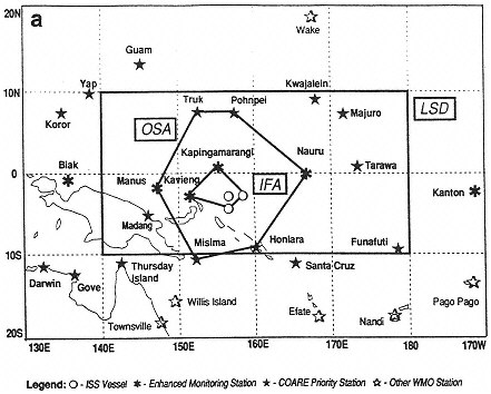
Figure 8. Composite structure of the Intensive Operation Period for TOGA COARE. The legend shows the symbols used to represent the different type of observational platforms. Various domains are labeled: the entire COARE domain (a), the Large-Scale Domain (LSD), the Outer Sounding Array (OSA), and the Intensive Flux Array (IFA). (From Webster and Lukas 1992, reprinted by permission of the American Meteorological Society.)
resources required for its implementation were contributed by nineteen nations, including the United States. Details on the contributions from Australia, China, the Federated States of Micronesia, France, Germany, Indonesia, Japan, Nauru, New Zealand, Papua New Guinea, the Philippines, the Republic of Korea, Russia, the Solomon Islands, Taiwan, the United Kingdom, and the United States can be found in WCRP 1993.
The objectives of COARE were to answer several questions:
-
What is the relationship of synoptic and mesoscale air-sea interaction in the warm-pool region to the large-scale, low-frequency behavior of the coupled ocean-atmosphere system?
-
How are air-sea fluxes of heat, moisture, and momentum in the warm-pool region modulated by synoptic and mesoscale atmospheric and oceanic forcing?
-
What are the structures and morphology of the synoptic and mesoscale components over the warm pool? and
-
What is the upper-ocean response of the warm pool to heat, moisture, and momentum fluxes associated with synoptic and mesoscale atmospheric systems?
TOGA COARE was motivated by:
-
the difficulty that coupled ocean-atmosphere models have in adequately simulating the mean state and variability of the thermal and flow fields in the lower atmosphere and upper ocean, because of large uncertainties in the components of the net air-sea flux, onset of atmospheric convection, and ocean mixing parameterization;
-
a death of high-quality measurements of air-sea fluxes of heat, moisture, and momentum in the western tropical Pacific;
-
uncertainty about the importance of the influence of rainfall upon buoyancy and mixing in the upper ocean;
-
concerns about the interpretation of space-based observations of sea surface temperature and surface wind; and
-
multiple-scale interactions that extend the oceanic and atmospheric influence of the western Pacific warm-pool area to other regions and vice versa.
Because of the size and complexity of TOGA COARE, a TOGA COARE International Project Office (TCIPO) was established in Boulder, Colorado, distinct from the Geneva-based International TOGA Project Office (ITPO). The TCIPO was charged with the daunting task of providing the logistical support required for the ground, air, and sea deployment of a multinational field campaign in a relatively remote portion of the world. U.S. resources for COARE
were provided by NOAA, NSF, NASA, the Office of Naval Research (ONR), and the Department of Energy (DOE). Of significant note were the successful efforts by the agencies to coordinate different agency missions and requirements to the benefit of COARE. An International TOGA COARE Data Workshop was held in Toulouse during August 1994 to address the multidisciplinary issues intrinsic to the objectives of the project.
The basic strategy for TOGA COARE was to obtain comprehensive atmospheric and oceanic data sets to guide the improvement and evaluation of coupled models. The 4-month IOP was embedded within a 2.5-year enhancement of the relatively sparse TOGA Observing System in the western equatorial Pacific. Observations were combined with model-based data assimilation to achieve the best description of the dynamics of the interactions between the ocean and atmosphere. Observations were nested in space to relate processes occurring on different scales.
The IOP was set for the northern-hemisphere winter (November 1992 to February 1993) to maximize the probability of strong westerly wind events, which were expected to be the periods of most intense air-sea interaction. Furthermore, November to February is a time of active transition during ENSO, while also being a period of the maximum strength of the east Asia winter monsoon. Leading up to the IOP, conditions in the tropical Pacific had relaxed from warm to near normal, with slightly cold surface waters in the eastern equatorial Pacific (see Figure 9). However, a cold event did not materialize and there was a return to warmer-than-normal surface waters in the central equatorial Pacific. TOGA COARE was conducted during the redevelopment of the warm phase of ENSO that had begun in 1991, allowing an unprecedented sampling of the conditions during a re-intensification of El Niño (Gutzler et al. 1994, Lukas et al. 1995).
COARE's strong emphasis on the measurement of air-sea fluxes was embodied in the Intensive Flux Array (IFA). Measurements of fluxes using eddycorrelation techniques were made from ships and from aircraft. Ship-, satellite-, and aircraft-based measurements also provided indirect estimates of fluxes. Doppler weather-radar measurements yielded high-quality estimates of rainfall over broad areas with high resolution. Dual-Doppler-radar measurements (measurements using two radars, making it possible to determine the horizontal wind speed and direction) from ship and aircraft provided detailed momentum-flux estimates for limited periods.
The large dynamic range of atmospheric and oceanic conditions observed during TOGA COARE confirmed hypotheses about the role of air-sea interaction in the warm pool and provided an excellent data set for model development. Strong intraseasonal atmospheric oscillations occurred, along with some episodes of westerly winds, including a strong westerly wind burst over the IFA
between 20 December 1992 and 3 January 1993. The burst generated an eastward-moving equatorial Kelvin wave, which caused the thermocline to deepen and the sea surface to warm across the equatorial Pacific Ocean. It directly forced the warm surface waters to move eastward. Also, the burst cooled the western Pacific through air-sea heat fluxes and upper-ocean mixing. The net effect was to displace the warm pool eastward.
Observations of rainfall over the ocean were made using Doppler weather radars on ships and on research aircraft. These observations provided the elusive areal averages of precipitation needed to compute the net air-sea flux of fresh water, as well as the detailed motions inside atmospheric convective systems. A new finding was that roughly 15 percent of the heavy rainfall over the warm pool occurs during shallow convection, which recycles local moisture rather than coming from moisture convergence on larger spatial scales. This observation of so-called “warm rain” has important implications for modeling the dynamic response of the atmosphere on large scales to convection in this region, and may be related to the inversion near the 0°C level (Johnson et al. 1996, Lin and Johnson 1996a). The observed IOP-average precipitation of 6 mm/day over the IFA (see Figure 8) agreed well with the average computed from the moisture budget derived from atmospheric soundings. The observed variability of precipitation compared reasonably well among these direct measures and with estimates based on SSM/I. However, estimates of precipitation variations from the GOES (Geostationary Operational Environmental Satellite) Precipitation Index differed substantially from the observations (Lin and Johnson 1996b).
Special time periods for instrument intercomparison helped to provide confidence in the accuracy of the fluxes. When estimates of heat flux were compared with changes in the heat content of the upper ocean, it appeared that the local budget of surface heat flux might be closed to within 10 Wm-2 for time periods of days to weeks, although contributions from horizontal advection were clearly important at certain times. An algorithm for improved estimates of heat fluxes using a bulk formula was developed (Fairall et al. 1996). Mesoscale atmospheric circulations associated with convection and precipitation were seen to modulate the air-sea heat flux.
Heavy rainfall events were found to be responsible for salinity and temperature changes that substantially modify upper-ocean mixing, and thus the heat and momentum fluxes. During the strong westerly wind burst of December 1992, the mixed layer deepened and cooled. When the burst ceased, heavy rains caused the mixed layer to become very thin, allowing it to warm very rapidly to temperatures near to those prevailing prior to the burst. However, the reduction of the mixed-layer thickness caused by the rains accompanying the westerly wind burst remained for a substantial period after the burst, leading to enhanced
sensitivity of sea surface temperature to subsequent wind events. Strong eastward surface flow forced by the westerly wind burst enhanced the vertical shear, which sustained mixing below the surface mixed layer for several days after the burst had ended (Smyth et al. 1996a, b), resulting in an even greater thermodynamic impact of the westerly wind burst on the warm-pool region.
Strong diurnal warming of the upper few meters of the ocean, sometimes as much as 4 K, was observed (Soloviev and Lukas 1996, Webster et al. 1996). This diurnal variation can lead to significant aliasing of sea surface temperature time series unless sampling takes place sufficiently frequently throughout the day. Also, the diurnal cycle increases the difference between skin and bulk sea temperatures. Caution is therefore necessary in the interpretation of climatological and satellite sea surface temperature data. Sampling frequency for satellite-derived sea surface temperature by infrared instruments is reduced by the abundant cloudiness of the warm-pool region, leading to potential biases.
Short-wave radiation penetrates to depths below the mixed layer, contributing significantly to heat content variations there, which could influence sea surface temperature and create temperature inversions. During the strong westerly wind burst, entrainment of nutrients into the mixed layer was associated with a phytoplankton bloom that, by increasing the turbidity, decreased the loss of penetrating solar radiation from the mixed layer, leading to an additional warming of about 0.1 K per month (Siegal et al. 1995).
While the results of the COARE experiment are still being analyzed and most of the work has not yet been published, some highlights have already emerged. The strategy of combining state-of-the-art turbulent-flux measurements on a few ships and aircraft, embedded in an observational array with high-quality in situ and remotely-sensed bulk measurements was successful. After a careful comparison of turbulence and bulk observations, made specifically to detect and resolve measurement problems, a revised bulk turbulent-flux algorithm has been developed (Fairall et al. 1996). This parameterization improves flux estimates under low-wind conditions, an important objective of COARE.
Prior to COARE, it was thought that the tropical atmosphere could sustain intraseasonal (40–60 day, or Madden-Julian) oscillations without any interaction with the ocean. Now, with COARE observations in hand, it is clear that the intraseasonal oscillation is a coupled phenomenon. The oceanic processes are highly correlated with the atmospheric processes, and phased so as to provide important feedbacks. These feedbacks have strong influences on the strength and propagation characteristics of the oscillations.
COARE observations and numerical simulations confirmed an hypothesis that the hydrological cycle is thermodynamically important for the upper ocean. Changes in local precipitation can alter the mixed-layer depth and thus alter the
rates of change in sea surface temperature during warming and cooling periods in the warm pool (Smyth et al. 1996b, Anderson et al. 1996). Increased rain rates, or reduced wind forcing, yield a shallow mixed layer and may lead to a net cooling of the sea surface, in spite of a net-positive heat flux because of loss of penetrating short-wave radiation through the base of the mixed layer. Decreased rain rates, or increased wind forcing, can initiate entrainment cooling of the surface mixed layer. Furthermore, the stabilization of the surface layer by rainfall leads to a shallower layer on which a given wind stress acts, thereby leading to larger ocean-surface currents (Weller and Anderson 1996) than would exist in the absence of rainfall.
Research aircraft and seagoing vessels equipped with Doppler radar collected measurements allowing description of a broad spectrum over the warm pool of precipitating clouds, ranging from isolated showers dominated by warm rain processes to huge “superclusters” reaching the tropopause. These data describe the mesoscale precipitation structure and momentum-flux characteristics of the atmospheric convection in both space and time (Mapes and Houze 1993, Chen et al. 1996). In tandem with carefully calibrated in situ thermodynamic measurements, these data sets will allow greatly improved estimates of the effects of organized atmospheric convection on air-sea fluxes to be made (see, for example, Young et al. 1995).
Central Pacific Experiment (CEPEX)
The Central Pacific Experiment (CEPEX) was conducted for one month (March 1993) following the TOGA COARE IOP (CEPEX [no date]). Its timing was motivated by a desire to utilize COARE resources already in the western Pacific and also to extend the COARE observations. CEPEX was designed to investigate hypotheses on the regulation of sea surface temperature. Two of these hypotheses are that cooling from evaporation limits sea surface temperature (Newell 1979, 1986) and that the reduction of incoming solar radiation by cirrus clouds is an important negative feedback to sea surface temperature (Ramanathan and Collins 1991). Improved understanding of various cloud feedbacks is particularly important for the development of the global climate models needed for the prediction of climate variability. CEPEX was a U.S. experiment funded by the NSF, DOE, NASA, and NOAA.
CEPEX was conducted in the central Pacific, to the east of the COARE IFA, between approximately 160°E and 155°W. It used a variety of platforms, including ships, aircraft, satellites, and the TOGA TAO array, to measure radiation and moisture, as well as the physical quantities that determine the response of sea surface temperature to radiative changes in the atmosphere.
Atmospheric soundings during CEPEX indicated that deep convection sharply increases mid-to upper-tropospheric moisture, with an enhancement of the greenhouse effect closely related to synoptic-scale convective events (Weaver et al. 1994). The enhanced greenhouse effect leads to significant radiative heating of both the surface and the atmospheric column by reducing the net outgoing flux of radiation. Upper-tropospheric mesoscale convective clouds contribute most of the satellite-derived cloud reflectivity in the central and western Pacific (Collins et al. 1996). Models for closure of the energy budget of the warm pool indicate that the effect of deep convection on surface insulation may be much larger than estimated by current general-circulation models (Ramanathan et al. 1995). Evaporation, computed from moored-buoy measurements, was anticorrelated with sea surface temperature in the western Pacific because of the light winds (Zhang and McPhaden 1995). The CEPEX data indicate that evaporative cooling is not sufficient to limit sea surface temperature and they do not rule out the importance of the cirrus feedback. A summary of the status of the debate on regulation of sea surface temperature has been provided by Waliser (1996).
Australian Monsoon Experiment (AMEX) / Equatorial Monsoon Experiment (EMEX)
During December 1987 to February 1988, the combined Australian Monsoon Experiment (AMEX)/U.S. Equatorial Monsoon Experiment (EMEX) was conducted over the tropical ocean north of Darwin, Australia. Funding for EMEX was provided by NSF and NOAA. It was the first atmospheric process study conducted under TOGA. The experiment investigated the oceanic mesoscale convective systems in the monsoon flow (Webster and Houze 1991). EMEX was designed to test the hypothesis that the net diabatic heating that results from equatorial convection is strongest in the upper troposphere. The net diabatic heating includes offsetting cooling from melting and evaporation of precipitation in and below stratiform cloud regions. The determination of the net heating profile resulting from convection in the equatorial region, and the factors that control it, is critical for predicting the scale of the dynamic response to convective episodes. The heating profile is necessary to understand the tropical forcing of the extratropics, one of the objectives of TOGA. AMEX/EMEX was designed to document, as thoroughly and directly as possible, the vertical profiles of vertical velocity, diabatic heating, and other structures of mesoscale tropical convective-cloud systems (“cloud clusters”) over the ocean near the equator. The physical mechanisms responsible for the convective and stratiform components of the observed cloud systems were examined. Airborne and surface Doppler radars, along with other instruments, measured
the horizontal and vertical air motions in ten major cloud systems (Holland et al. 1986).
The heating profiles observed during AMEX/EMEX had maxima that were stronger and higher than those observed during the GARP (Global Atmospheric Research Program) Atlantic Tropical Experiment (GATE) (see Figure 3 of Webster and Houze 1991). This finding has important implications for understanding the forcing of the large-scale circulation by convective heating. The information obtained during AMEX/EMEX helped guide the development of TOGA COARE.
Line Islands Array (LIA)
In the early 1980s, various oceanic, equatorially trapped, baroclinic-wave modes that exist in theory were the subject of wide debate. Their actual existence and their hypothesized role in the development of anomalies on interannual time scales of sea surface temperature were questioned. Oceanic synoptic-scale (20–80 day periods) oscillations of sea level, temperature, and currents in the central equatorial Pacific were observed to appear intermittently and with different meridional structures (Legeckis 1977, Hansen and Paul 1984, Wyrtki 1978, Mitchum and Lukas 1987). Synoptic oscillations include variability with time scales of a few days to a few months, as well as phenomena like tropical instability waves* and Kelvin-wave pulses. The role of these oceanic synoptic waves in the heat and momentum budgets near the equator was unknown, but thought to be significant. The 1985–1989 Line Islands Array (LIA) experiment in the central equatorial Pacific was deployed to observe synoptic oscillations of sea level in relation to seasonal and interannual variations. Pronounced seasonal and interannual modulation of these synoptic oscillations appeared to be directly forced by both varying wind stresses, and by the strong and variable zonal near-equatorial flows.
The scientific goals of the LIA project were to resolve the meridional sea-level structures associated with these oscillations, correlate these structures with the mean currents, and define the relationship between the growth and decay of the synoptic oscillations and the variation of the equatorial currents. The practical objective of the LIA was to make time series of sea-level observations with an array of instruments between 10°N and 9°S over a five-year period. The LIA was composed of tide gauges and shallow pressure gauges at island sites, and inverted echosounders at deep ocean sites. Five research expeditions were conducted to maintain the array, and to provide shipboard measurements
of thermohaline and velocity structure. The LIA was funded by NSF and NOAA as a contribution to TOGA.
The LIA captured the full range of interannual variability, including one ENSO warm event and one cold event (Chiswell et al. 1995), supporting the overall objectives of TOGA. Interannual and interseasonal variability of dynamic height was dominated by first-baroclinic-mode Kelvin waves. Intraseasonal variability was dominated by an asymmetric mode with maximum energy to the north of the equator. Long records of sea level in the tropical Pacific were analyzed to provide a climatological perspective on sea-level variability with periods between 2 days and 90 days as a function of latitude. The analysis showed pronounced changes with latitude and differences between ENSO and non-ENSO periods (Mitchum and Lukas 1987). The LIA observations have been used to refine the meridional resolution of these results (Donahue et al. 1994, Chiswell et al. 1995).
Observations from the LIA revealed fluctuations of sea-level, coherent over a wide range of latitudes, with frequencies in the synoptic band (Mitchum and Lukas 1987, Donahue et al. 1994, Chiswell et al. 1995). The variability in the synoptic band was modulated on longer time scales by ENSO. The 1986–87 ENSO produced changes in the meridional and vertical shears of the zonal equatorial currents, and variations in the Madden-Julian Oscillation (McPhaden and Taft 1988, Enfield 1987). The mean meridional structure of the variability determined from the LIA agreed very well with Geosat altimeter observations and with ocean model simulations (Metzger et al. 1992, Donohue et al. 1994). Subsequent investigation of the variability in the synoptic spectral band continued during TOGA COARE. Of particular interest, for example, is whether or not there is a downstream rectification of sea-surface-temperature variations associated with synoptic disturbances traveling from the western equatorial Pacific to the central and eastern equatorial Pacific, causing seasonal and longer variations in the central and eastern region.
Tropic Heat
The Tropic Heat program examined the processes that contribute to the maintenance and evolution of the cold-water tongue in the eastern and central equatorial Pacific. It was initiated prior to TOGA; the initial intensive field experiments took place during the boreal fall of 1984. The program continued through a second set of intensive field experiments during boreal spring of 1987. The original objectives were to:
-
relate the ocean-atmosphere heat flux to oceanic heat storage,
-
measure horizontal advection of heat in the ocean,
-
learn how best to measure turbulence at the equator, and
-
develop and understand the modeling of the ocean thermodynamic structure.
The location of the field programs was the region bounded by 5°N, 10°S, 150°W, and 110°W. This region includes most of the cold tongue of the eastern Pacific. The most intensive measurements in 1984 were made at the crossing of the equator and 140°W, near the already-in-place long-term NOAA/EPOCS mooring. Turbulence and fine-structure measurements made at that location were the first systematic and extensive observations of turbulence (sustained for 12 days) taken anywhere in the upper ocean, let alone at the equator. Detailed shipboard measurements of air-sea fluxes were compared to satellite observations, providing early guidance for the TOGA Heat Flux project, as well as for TIWE (Tropical Instability Wave Experiment) and COARE.
Previous notions of a steady-state shear-driven turbulence were demolished by the results of Tropic Heat (Moum et al. 1989). It was discovered that solar heating suppressed turbulence in the surface layer, while nighttime turbulence levels extended well below the surface layer into the stratified fluid. Extended analyses demonstrated that the upper 25 meters of the ocean, over broad areas of the equatorial Pacific, loses significantly more heat during night times than during day times.
Tropic Heat II
The focus of observations for the second field program of Tropic Heat, in 1987, was the cycle of deep mixing. Links were observed between the cycle of deep mixing and both internal waves and/or shear instabilities above the core of the Equatorial Undercurrent (EUC). These observations prompted many modeling efforts to explain the physical sequence of events. The significance of internal waves in zonal momentum transport has been elucidated but not yet well quantified. While the 1984 Tropic Heat experiment suggested that internal waves provided a large source of momentum transport, this result was not confirmed by the 1987 measurements. Whether this difference should be attributed to the different seasons of the two experiments, the presence of an El Niño in 1987 but not in 1984, a strong Equatorial Undercurrent in 1984 compared to a weak one in 1987, or simply limited (however extensive) measurement periods, is not known.
One of the original goals of the Tropic Heat experiments was to parameterize mixing, in terms of larger-scale flow indices, for use in models. This goal has proven elusive, as the physics of small-scale processes in the flow field has been found to be quite complex. COARE analyses continue to pursue this objective.
Tropical Instability Wave Experiment (TIWE).
The primary objective of the Tropical Instability Wave Experiment (TIWE) was to describe the space/time evolution of tropical instability waves, with emphasis on divergence, vorticity, and energy propagation. Other objectives were to provide detailed estimates of the Reynolds fluxes associated with these waves and of the role of these fluxes in the heat and momentum balances; to determine the eddy energy balances; to estimate the cross-equatorial Reynolds heat flux attributable to the waves and its divergence; and to estimate the three-dimensional advection of heat associated with the waves. The field campaign was conducted during 1990 and 1991 near 0° latitude, 140°W, in conjunction with the NOAA/EPOCS study of the North Equatorial Countercurrent. Funding for TIWE was provided by NSF.
TIWE consisted of a moored-buoy array along 140°W, where the instability waves are energetic (Halpern et al. 1988), together with satellite-tracked drifting buoys and ship surveys. Special attention was devoted to the cusp-like wave structures characteristic of the instability waves evident in fields of sea surface temperature. Conditional sampling of the thermohaline and velocity structures associated with fronts in the upper ocean was assisted by AVHRR images received directly on board one of the research vessels (Flament et al. 1996). Drifting buoys revealed the complicated circulations associated with the instability waves, especially the asymmetry of their occurrence with respect to the equator, as well as temperature changes of parcels of water as they move.
North Equatorial Countercurrent (NECC) Study
The North Equatorial Countercurrent (NECC) Study, part of EPOCS, examined the role of the NECC in the heat balance of the eastern equatorial Pacific. The field campaign, which occurred during 1988–1991 near 140°W, was coordinated with TIWE. A moored-buoy array centered at 7°N, 140°W was deployed. The NECC Study provided the first observations using direct current measurements of the interannual variability of the NECC. Other in situ measurements came from drifting buoys and ship surveys of upper-ocean thermohaline and current structures. The objectives of the study were to document sea surface temperature, wind, and upper-ocean thermal and flow fields in the NECC; to understand the dynamics of NECC variability and the oceanic response to wind forcing in the vicinity of the Inter-Tropical Convergence Zone (ITCZ); and to provide, within the framework of the TAO array, additional data sets for initializing and validating operational model-based analysis systems. NOAA supported the EPOCS NECC Study.
The annual cycle and a 30-day oscillation in winds and upper-ocean current and temperature in the NECC along 140°W were observed (McPhaden and Hayes 1991). Instability waves with a 30-day period were strongest during July-February, and stronger in 1988 and 1989 (coincident with an ENSO cold phase) than in 1990 and 1991. Variations of sea surface temperature with a 30-day period were greatest near 2°N, where there is a sharp meridional temperature front. However, below the surface, variations in temperature with a 30-day period were greatest around 5°N, associated with vertical and meridional displacements of the sharp thermocline (McPhaden 1996). The latitudinal location of this subsurface maximum in temperature variance coincided roughly with a region of high meridional shear on the southern flank of the NECC, near its boundary with the South Equatorial Current. The energetics of the tropical instability waves, as well as their seasonal and interannual modulation by the large-scale wind-driven circulation, are still to be investigated.
Western Equatorial Pacific Ocean Circulation Study (WEPOCS)
The ocean circulation in the western equatorial Pacific, near the maritime-continent archipelago, was poorly known at the start of the TOGA Program. To improve the description of ocean circulation in the warm pool, the Western Equatorial Pacific Ocean Circulation Study (WEPOCS) was organized as a joint field campaign by the United States and Australia. Several ship surveys making thermohaline and current-profile measurements were conducted between 1985 and 1990. Special efforts were made on some expeditions to estimate air-sea heat fluxes. The sea-level measuring array in the region was enhanced and current-meter moorings were deployed. WEPOCS intended to examine the effect of the monsoon on the upper-ocean circulation in the region north and east of Papua New Guinea, determine the source waters of the EUC, describe the confluence of northern and southern waters in the area that opens into the Indonesian Seas, describe the system of low-latitude western boundary currents, and describe the related deep and intermediate ocean. U.S. participation in WEPOCS was supported by NSF.
An hypothesis that the origin of the EUC is associated with a western boundary current along Papua New Guinea was confirmed by Tsuchiya et al. (1989). The New Guinea Coastal Undercurrent, which supplies approximately two-thirds of the transport of the EUC at its origin, was discovered during WEPOCS (Lindstrom et al. 1987). The other one-third of the EUC transport is produced by the Mindanao Current, which is subject to strong interannual variability (Lukas 1988) around an annual-mean upper-ocean transport of about 26 Sv (Lukas et al. 1991). Both western boundary currents participate in the
Indonesian Throughflow and the equatorial circulation across the Pacific basin (Fine et al. 1994). We have yet to determine how interannual variations of low-latitude western boundary currents influence the warm pool of the western equatorial Pacific.
Coastally trapped Kelvin waves observed using sea-level measurements propagate towards the equator along the coast of Papua New Guinea. The annual cycle of sea level near 7°N, which is strongly modulated by ENSO, resembles a Rossby wave that propagates westward in phase with zonal wind variations, growing in amplitude to the west (Mitchum and Lukas 1990).
Lukas and Lindstrom (1991) discovered the important role of salinity in determining the mixed-layer depth in the warm pool, with salinity changes driven by the heavy rainfall associated with the ascending branch of the Walker circulation. Subduction of warm salty water from the central equatorial Pacific below the less saline water of the warm pool, along with vertical mixing, provides the time-averaged balance to the freshwater flux (Shinoda 1993, Shinoda and Lukas 1995). Questions raised by WEPOCS observations of the upper ocean and measurements of air-sea fluxes were instrumental in the development of TOGA COARE.
Western Tropical Atlantic Experiment (WESTRAX)
The Western Tropical Atlantic Experiment (WESTRAX) was conducted during 1990 to 1993 because of its relevance to TOGA COARE (Brown et al. 1992). Thermohaline and current-velocity-profile measurements were made during ship surveys, current-meter moorings and an echo-sounder array were deployed, and surface drifters and subsurface floats were deployed. The primary objective of WESTRAX was to investigate the mechanisms driving cross-equatorial and cross-gyre fluxes of heat, salt, and momentum. Earlier studies of the western tropical Atlantic region suggested that western boundary currents were continuous from the equator to the Caribbean Sea during boreal spring and were primarily responsible for the fluxes. WESTRAX was supported by NSF and NOAA in the U.S., as well as by France and Germany.
WESTRAX identified several new mechanisms for cross-equatorial and cross-gyre exchanges of mass along the western boundary of the Atlantic Ocean. Johns et al. (1990), using Coastal Zone Color Scanner (CZCS) satellite images of phytoplankton-pigment concentrations and current-meter data, described eddies that separate from the North Brazil Current retroflection and then propagate northwestward along the boundary. These eddies have also been observed in satellite altimetry data (Didden and Schott 1993) and subsurface float data (Richardson and Schmitz 1993, Johns et al. 1990). Didden and Schott (1993) estimated an annual-mean volume transport of 3 to 4 Sv associated with
these eddies. Mayer and Weisberg (1993), using climatological data, inferred that cross-gyre transports might occur as a rectification of the annual cycle. Near-surface flow crosses the equator at the western boundary, retroflects into the North Equatorial Countercurrent during boreal summer, and then is swept northward into the subtropical gyre by Ekman transport in boreal winter. About 12 Sv may be accounted for by this mechanism. Also, equatorward cross-gyre exchange was observed. According to Wilson et al. (1994), a portion of the North Equatorial Current returns eastward in both the North Equatorial Countercurrent and the sub-thermocline North Equatorial Undercurrent. The North Equatorial Countercurrent and the North Equatorial Undercurrent also transport water from the North Brazil Current, which was retroflected from the boundary. Northern Hemisphere and Southern Hemisphere water masses are mixed along the western boundary between the North Brazil Current and the North Equatorial Current. An intense subsurface countercurrent extends from the Caribbean to either the North Equatorial Countercurrent or the Equatorial Undercurrent (Molinari and Johns 1994, Johns et al. 1990, Wilson et al. 1994, Colin and Bourles 1994, Schott and Boning 1991). This subsurface current may also contribute to the blending of water masses from the southern and northern hemispheres.
Few of the available data or recent modeling results indicate a continuous northward flow along the western boundary of the Atlantic from the equator to the Caribbean during any season. A monitoring program has been established in the passages of the southern Lesser Antilles to determine whether a significant amount of water from the Southern Hemisphere crosses the equator and enters the tropical-subtropical gyre. Additional modeling and data analyses are being conducted to quantify the roles of continuous boundary currents, eddies, and Ekman fluxes in interhemispheric exchanges of mass and heat.
Equatorial Pacific Experiment (EqPac)
EqPac was a process study of the U.S. Joint Global Ocean Flux Study (JGOFS; Murray et al. 1992), organized in conjunction with TOGA. The purpose of EqPac was to examine the three-dimensional physical and biological processes in the equatorial Pacific cold tongue that determine carbon cycling, the effects of nutrients (including iron) on the biota, and the effects of both on the carbon fluxes. It was conducted in two phases, February-May 1992, when the water was relatively warm (see Figure 9), and August-October 1992, when the eastern Pacific had reverted to relatively normal cold-tongue conditions. The study involved extensive collaboration between NSF-and NOAA-supported components. NSF sponsored process-oriented cruises, mostly on a meridional slice at 140°W from 10°S to 10°N. NOAA supported a semi-synoptic survey consisting
of four meridional sections from 95°W and 170°W, providing the context in which the 140°W sections were imbedded. The experiment also included over-flights supported by NASA and an iron-fertilization experiment supported by ONR.
The EqPac study found that physical factors in the ocean (thermocline variations, tropical instability waves, and the warm and cold phases of ENSO) are the main factors controlling chemical and biological variability (Murray et al. 1994). It was verified that the release of carbon dioxide to the atmosphere varies with the phases of ENSO—smaller during warm conditions (when the thermocline is relatively deep and the carbon-rich waters communicate least effectively with the surface) and larger during cold conditions. Macro-nutrients (e.g., nitrate) were also higher during the cold period, but this elevation contributed little to the chemical and biological differences during the two periods. The particulate export of carbon from the euphotic zone to the rest of the ocean was generally lower in the equatorial Pacific than one would expect from the general level of surface nutrients. Dissolved organic carbon appears to be a significant part of the export of carbon. The relatively low values of primary and export production during the EqPac period, and the differences between the warm and cold periods, were attributed to controls by the composition and size structure of the biological community, possibly influenced by the availability of iron, rather than by the availability of macro-nutrients.
MODELING ENSO
The major modeling advance of the TOGA period was the successful simulation of the ENSO cycle using coupled models of the atmosphere and ocean for the region of the tropical Pacific. Great strides were made in understanding the importance of wind stress from the atmosphere for determining sea surface temperature, and also in understanding the importance of sea surface temperature in forcing atmospheric conditions.
The TOGA decade saw many advances in modeling the ocean and atmosphere in and over the equatorial Pacific. The truly crucial advance was the advent of coupled atmosphere-ocean models for ENSO simulations. Necessary for these coupled models was the development of the ability of ocean models to accurately simulate sea surface temperature in response to the observed winds. While coupled atmosphere-ocean models had existed for 30 years before the start of TOGA, they lacked the near-equatorial spatial resolution needed to represent the waves and upwelling processes essential for the simulation of
ENSO. This section leads to a discussion of coupled models, after first examining the component ocean and atmosphere models, but it should not be construed as a complete review of modeling for the TOGA Program.
Ocean Models
Two major advances in tropical ocean modeling during the TOGA decade were the simulation of sea surface temperature in a variety of ocean models, and the development of an operational hindcast*-analysis system for the tropical Pacific Ocean.
The pre-TOGA years saw the maturation of the linear theory of equatorial ocean waves—their excitation by wind stresses, their propagation eastward as Kelvin modes and westward as Rossby modes, and their effect on vertical displacements of the thermocline. Back then, multilevel primitive-equation models of the equatorial ocean were successful in simulating the thermal structure of the upper equatorial ocean, its current system, and its thermal and momentum responses to changes in the winds (see, e.g., Philander 1981; Philander and Pacanowski 1981a, b). However, sea surface temperature was not routinely simulated. While it was known which processes affected sea surface temperature and its variability (see Sarachik 1985 for a review), the upper-ocean mixing processes were inadequately represented for accurate simulation of sea surface temperature and its variability.
In order to simulate variations of sea surface temperature with a dynamical model, heat and momentum fluxes at the surface must be accurate, upwelling and upper-ocean thermal structure must be correct, and upper-ocean mixing must be well parameterized. A parameterization of vertical mixing based upon the Richardson number (Pacanowski and Philander 1981) allowed the simulated values to be large near the surface of the ocean and very small in the interior, both conditions more realistic than in previous simulations. This representation of upper-ocean mixing then allowed the first reasonable simulation of sea surface temperature anomalies in the context of modeling ENSO (Philander and Seigel 1985).
Parallel to these modeling developments, a simpler approach was pursued by Zebiak (1984). He used a reduced-gravity model with an embedded fixed-depth mixed layer. The mean annual cycle in the ocean was specified and only the anomalies of sea surface temperature were calculated. Because the temperature of the mixed layer was calculated explicitly, the thermal equation for the mixed layer determined the anomalies of sea surface temperature. The temperature of the water entrained at the bottom of the mixed layer was parameterized
in terms of the thermocline quantities. The Zebiak model proved capable of simulating the anomalies of sea surface temperature characteristic of ENSO.
Heat fluxes at the ocean surface play a central role in controlling the variability of sea surface temperature, especially variability related to the annual cycle. Models with simple parameterizations (see, e.g., Seager et al. 1988) have been able to simulate the annual cycle and the full range of variability in the tropical regions to within a degree or two (Seager 1989). For interannual variations, advection—especially upwelling—seems to be the crucial process controlling sea surface temperature in this class of model.
The development of realistic ocean general-circulation models, at the same time that observations of the thermal structure of the upper Pacific became available in real time, encouraged the creation of the first operational ocean-analysis system (Leetmaa and Ji 1989). The data were quality controlled and inserted into a model based on the general-circulation model pioneered at NOAA's Geophysical Fluid Dynamics Laboratory. The hindcast and analysis system interpolates the observations onto a regular grid, thereby creating ocean-wide thermal and flow fields. This operational ocean model became the ocean component of the coupled prediction model at NMC, and its initial state was the initial state for coupled predictions on seasonal-to-interannual time scales.
Atmospheric Models
In order to ensure correct coupling to ocean models, atmospheric models must produce the correct surface fluxes of heat and momentum in response to a specified sea surface temperature. Until the early 1980s, the surface fluxes in atmospheric models were hardly examined; the middle and upper tropospheric fields were considered the sine qua non of atmospheric modeling. The need for modeling atmosphere-ocean interactions required improvements in four areas: cumulus convection parameterization, boundary layers in both fluids, and interactions between radiation and clouds.
Cumulus clouds must be parameterized correctly in order to simulate rain in the correct amounts, at the correct places, with the correct cirrus outflows. Both rain and cirrus outflow are important for driving atmospheric circulations. The cirrus outflow helps determine the amount of radiation reaching the surface and hence affects the sea surface temperature. Boundary-layer plumes and shallow clouds mix momentum down from the free atmosphere (say, at 800 mb) to the surface, helping to determine the surface winds. Plumes and clouds also mix moisture from the surface to the top of the boundary layer, helping to determine the amount of moisture available for convergence into precipitating cumulonimbus clouds. Boundary layers in the tropics can be trade-cumulus layers, stratus-topped layers, or layers making the transition between the two.
Stratus-topped layers, which exist mostly over the cooler waters, intercept the incoming solar flux, thereby helping to maintain the relatively cold sea surface temperatures. The interactions of radiation with clouds and with aerosols are crucial ingredients in the correct simulation of the temperature structure of the atmosphere and in the correct simulation of the radiative fluxes reaching the surface.
The simplest models of the tropical atmosphere are based on the work of Gill (1980, 1982). In these two-layer thermal models, the surface winds are determined by the low-level convergence and upper-level divergence required by the thermal forcing. Improvements to these models include convergence feedback (Zebiak 1986) and the combining of the Gill-type model with explicit boundary layers (Wang and Li 1993). The coupling of such models to simple ocean models forms the basis of “intermediate modeling”.
The next stages in complexity approach the complexity of full general-circulation models. The insertion of complex boundary layers, both trade-cumulus and stratus topped, are major undertakings and have not yet been fully implemented in general-circulation models, although it is known that their absence severely limits the accuracy of coupled models.
Coupled Models
The major modeling advances made during the TOGA period involved the successful simulation of the ENSO cycle by means of coupled atmosphere-ocean models of the tropical Pacific. The first successful coupled model of ENSO consisted of a Gill-type model (Gill 1980) of the atmosphere, with improved moisture convergence (Zebiak 1986), coupled to a reduced-gravity ocean model with an embedded surface mixed layer (Zebiak and Cane 1987). A novel feature of the Zebiak and Cane model was a fixed-depth frictional surface layer embedded in the uppermost dynamic layer of the modeled ocean, allowing a simple representation of the near-surface intensification of wind-driven currents in the real ocean. A complete thermodynamic equation was used for this surface layer, including all advection and upwelling terms. This model proved successful at simulating the time development of sea-surface-temperature anomalies during an ENSO cycle, at generating the correct time scale of recurrence of warm and cold events, and in producing reasonable decadal variability of the warm and cold phases of ENSO. This coupled model also predicted the 1987 warm phase of ENSO a full year in advance, and thereby provided the first successful short-term climate prediction based on a coupled model.
The success of the Zebiak and Cane (1987) models provided the encouragement to couple more realistic and complex atmosphere and ocean general-
circulation models. The complexity and difficulty of the task proved greater than foreseen (Neelin et al. 1992). It was well understood that the ocean component had to produce the correct sea surface temperature in response to the fluxes of heat and momentum from the atmosphere. It was also understood that the modeled atmosphere had to produce the correct surface fluxes in response to the sea surface temperature. What was not appreciated is how sensitive each model is to errors in the other.
The original attempts to couple the atmosphere to the ocean ran into problems; the final state turned out to be far from a realistic one (see, e.g., Manabe and Stouffer 1988). In order to restore a more realistic climate state, the artificial expedient of “flux corrections” was adopted, viz., the arbitrary imposition of surface fluxes designed to force the modeled state to a realistic one (Saucen et al. 1988). These flux corrections have proven detrimental to simulations of climate change because they always tend to bring the climate state back to the original one, regardless of the state to which the changes in the forcing should impel the model. Improved coupled models have produced realistic interannual variability, representative of ENSO, without the need for flux corrections (Philander et al. 1992, Nagai et al. 1992), but only in the absence of the annual forcing of insolation.
The annual cycle is subtle and difficult to simulate. It involves processes in the atmosphere and ocean different from those governing interannual variability (Köberle and Philander 1994). In particular, heat fluxes play a more important role in the annual cycle than the interannual cycle. For example, stratus clouds seem to be crucial for modulating the heat fluxes needed to produce the annual cycle, especially in the coastal regions of the equatorial and South Pacific (Klein and Hartmann 1993). In the cold-tongue regions, stratus clouds influence the far-eastern Pacific (say within 1000 km of the coast), where the variations of the heat fluxes through the ocean surface are in phase with the variations of sea surface temperature. However, stratus clouds appear to be unimportant for modulating interannual variations of the cold tongue in regions away from the coast, where the variations of heat fluxes and sea surface temperature are out of phase. The unrealistic warmth of all existing coupled general-circulation models at the far eastern part of the cold tongue has been attributed to the inability of the models to successfully simulate the stratus clouds and their effects (Mechoso et al. 1995).
At this writing, coupled models are just beginning to produce combinedannual and interannual sea-surface-temperature variability without theartificial expedient of flux corrections (Latif et al. 1993, Schneider and Kinter 1994, Robertson et al. 1995a), although the modeled variability is not yet totally realistic (Mechoso etal. 1995). The challenge remains for coupled models to simulatesuccessfully both annual and interannual variability in the tropics.
PREDICTION
All objectives of the TOGA program were related to improving prediction, or quantifying predictability, of short-term climate variations. Progress towards achieving these objectives ranks among the greatest successes of TOGA. Not only was the basis of climate predictability established through ENSO theories and models, but by the end of TOGA, regular and systematic experimental ENSO predictions had been underway for several years.
It is generally thought that the intrinsic variability of the atmosphere creates a barrier to predictions beyond approximately two weeks (Lorenz 1965, 1982; Charney et al. 1966). However, the slowly evolving nature of the ocean, together with the strong coupling between the ocean and atmosphere, allows that barrier to be avoided. Charney and Shukla (1981) pointed out that the muted high-frequency atmospheric variability of the tropics made the atmosphere there highly dependent on its boundary conditions, and therefore much more predictable on time scales associated with the slow variation of those boundary conditions. Prediction of sea surface temperature, a boundary condition for the atmosphere, allows the forecast of concomitant atmospheric statistics.
Predictions of eastern tropical Pacific sea surface temperature can be made a season to a year or more in advance (e.g., Latif et al. 1994). While weather cannot be predicted further ahead than a week or two, seasonal climatic variables for particular regions of the world directly affected by ENSO can be predicted. The TOGA period has seen this concept developed and demonstrated in practice. The TOGA Program fostered development of both statistical and dynamical prediction models, established a coordinated prediction program that is the prototype of a multinational climate-prediction enterprise, and created operational climate predictions. Prediction products are routinely disseminated and used worldwide.
Many diverse definitions of forecast skill have been used to evaluate weather predictions. At this early stage in the development of climate forecasts, only simple measures of skill are in regular use. The most common measures are (1) the correlation of a forecast with the NINO3 index and (2) the average of the root-mean-square error over the length of a forecast. These two measures give a simple indication of how well phase and amplitude have been predicted over the length of a record. More sophisticated measures compare the success of a forecast to the success of persistence and/or climatology.
It should be noted that there is predictability in the sea-surface-temperature fields simply because of their persistence. The autocorrelation of the index
called NINO3 (the anomaly of sea surface temperature averaged over the region between 5°N and 5°S, 150°W and 90°W), for example, shows a 0.5 autocorrelation with a lag of 6 months. Clearly, the correlation of a prediction of NINO3 with observations must beat this value in order to demonstrate useful skill. With a lag of 3 months, the autocorrelation of NINO3 is about 0.7. Skill in predicting sea surface temperature, as measured by the correlation of observed and predicted time series, is expected to have its greatest value for lead times exceeding 6 months, when the value of persistence forecasts is low.
Inoue and O'Brien (1984) provided the first ENSO predictions using a numerical model. In their prediction scheme, a dynamic ocean model forecast the evolution of the thermocline depth in the eastern Pacific, assuming that surface wind-stress anomalies remained fixed at their initial values. The model clearly demonstrated a predictive potential at lead times of several months, even though sea-surface-temperature and atmospheric fields were not explicitly forecast.
Prediction schemes for ENSO based on statistical models were introduced by Graham et al. (1987a, b). In these schemes, sea-level pressure or tropical Pacific winds are used to predict sea surface temperature. A significant issue in the construction of such models is the appearance of artificial skill, i.e., the tendency of a statistical scheme with many degrees of freedom to produce results which are arbitrarily good in hindcast mode (reproducing the data used to construct the model), but poor in true forecast mode. Graham et al. minimized artificial skill by reducing the degrees of freedom in the model through the use of empirical orthogonal functions (EOFs). Others have used principal-oscillation patterns (Xu and von Storch 1990; Penland and Magorian 1993). The results of these schemes are clearly superior to persistence forecasts, providing correlations of about 0.5 with lead times of 9 months for predictions of sea surface temperature in the eastern Pacific (Latif et al. 1994, Barnston and Ropelewski 1992). Prediction correlations at this level using statistical models demonstrate clearly the large-scale, low-frequency nature of ENSO, as well as a significant degree of linearity in its evolution over time scales of several seasons.
By the close of the TOGA Program, monthly statistical forecasts were being made by the Climate Analysis Center for 3-month-mean sea surface temperature in several regions of the tropical Pacific and Indian Oceans (Graham et al. 1987a, b; Barnston and Ropelewski 1992). Forecasts were made with lead times up to 12 months. Results indicated that the 170°W-120°W region of the equatorial Pacific is the most predictable. For forecasts with a lead of 6 months, the anomaly correlation score for the last decade over this region is 0.7. Skill is greatest for boreal winter forecasts made at the end of the summer. Forecasts made during winter for the following summer exhibit considerably less skill.
Statistical forecasts outperform persistence in the equatorial Pacific under most conditions. Similar statistical techniques have also been implemented to forecast North American air temperature and precipitation (Barnston et al. 1994), but with forecast correlations for seven-month lead times not exceeding 0.3.
The first coupled atmosphere-ocean model applied to ENSO prediction was that of Zebiak and Cane (1987). Only departures from monthly-mean atmospheric and oceanic climatologies were explicitly calculated. As the climatology was specified from observations, the mean state was guaranteed to be realistic. Atmospheric dynamics were approximated by a steady, linear, “shallow water”* system, following the work of Gill (1980) and later modified by Zebiak (1982, 1986) for use in modeling ENSO. Oceanic dynamics were also approximated by linear, shallow-water equations, following the work by Busalacchi and O'Brien (1980, 1981). The Zebiak and Cane model simulated a realistic ENSO. Analyses by Zebiak and Cane, Battisti (1988), Suarez and Schopf (1988), and Schopf and Suarez (1988) highlighted the crucial role of ocean dynamics in supplying a delayed negative feedback that sustained the oscillations in the models. The “delayed action oscillator” theory of ENSO (Battisti and Hirst 1989; Wakata and Sarachik 1991a; Jin and Neelin 1993a, b; Neelin and Jin 1993) is now the most widely accepted explanation of ENSO (see Battisti and Sarachik 1995 for more details).
Regular predictions of ENSO on an experimental basis, using the Zebiak and Cane model, began in 1985 (Cane et al. 1986). Figure 10 shows the evolution of the correlation skill for a set of hindcasts of the NINO3 index for El Niño events of 1976 and 1982–1983, and the nonevent years of 1977–1979. The forecasts of these different periods were all largely successful at lead times of a year or more. The overall correlation skill (i.e., the correlation between the predicted and observed index) for NINO3 forecasts during this period was above 0.6 for lead times up to 11 months. Such success is particularly remarkable in view of the highly simplified initialization procedure that was used. Initial conditions of the ocean for each forecast were obtained by forcing the ocean model with analyzed surface winds based on data from VOS (Goldenberg and O'Brien 1981), often marginal in quality because of poor coverage. Initial conditions of the atmosphere were derived from the ocean-model simulation of sea surface temperature. Thus, no observations of sea surface temperature or subsurface temperatures were utilized. That such a simple scheme could allow skillful predictions strongly reinforces several prevailing ideas about ENSO: it is a large-scale, low-frequency signal; the important “memory” of the coupled system resides in the pattern of upper-ocean heat content; and, finally, the heat-content variability is largely controlled through surface forcing by wind stress,
Figure 10. Correlations for predictions of anomalies of equatorial sea surface temperature using fully coupled atmosphere-ocean models. The curve labeled “Lamont” shows results obtained with the coupled model of Zebiak and Cane (1987). The curve labeled MPI shows results obtained with the coupled general-circulation model of Latif et al. (1993). The curve labeled “Lamont (20 cases)” shows the anomaly correlations for the Lamont model when applied to the same 20 cases to which the MPI model was applied. Also shown, for reference, is the result of persistence forecasts. (Reprinted with permission from Latif et al. 1994, copyright Springer-Verlag.)
in accordance with linear, shallow-water dynamics. The results from coupled models justify an optimistic assessment of the additional predictive potential of more detailed models and assimilation systems that could take advantage of all available observations. We can clearly see from the figure that while the overall skill of the Zebiak and Cane model is useful, there are specific times when the forecast skill is considerably higher than other times. Conversely, predictions made during boreal spring are considerably worse than the mean. The skill of the Zebiak and Cane model has been recently increased by more careful initialization, which not only reduced the nowcast error, but also increased the correlation skill out to more than a year (Chen et al. 1995).
The first ENSO forecast using coupled numerical models, made in early 1986 (Cane et al. 1986), predicted a warming event for later that year. The forecast for January 1987, made with a lead time of one year, was essentially
accurate, although the rapid warming in 1986 occurred about 3 months later than had been predicted. Barnett et al. (1988) compared the predictions for 1986–1988 made using the Zebiak and Cane model with predictions from the statistical forecast model developed by Graham et al. (1987a, b), and found similar performance at lead times of 9 months or less. Evaluated over a longer record, the performances of the dynamical and statistical models are comparable for lead times of 4 months or less, but dynamical predictions are increasingly superior at longer lead times (Latif et al. 1994).
In 1991, after informal discussions with members of the TOGA Panel, the TOGA Project Office began a program to further develop the new field of short-term climate prediction. The program, the TOGA Program on Prediction (T-POP, described in Cane and Sarachik 1991) was designed to be inclusive, supporting all the ongoing research in the United States on short-term climate prediction. Its focus was the development of prediction systems—models, data-assimilation techniques, and data quality control—based primarily on coupled atmosphere-ocean general-circulation models. In addition to prediction research, T-POP concentrated on making experimental predictions and on inter-comparisons of predictions for designated time periods.
Forecasts using coupled models require initialization of only the ocean components of the model because, in most instances, information about the atmospheric initial state is lost within the first two weeks of the model run. The simplified prediction systems (e.g., the one developed by Cane and Zebiak) use the history of wind stress to initialize the state of the ocean. During TOGA, a real-time ocean-analysis system (Ji et al. 1994b) was implemented at NMC. The NMC system provided forecasts of sea surface temperature for the tropical Pacific, as well as forecasts of rainfall and surface temperature around the globe. The skill level of this model for about the first two seasons was higher than that of other systems because an observed ocean thermal state is used for initialization rather than a proxy based on the history of the winds (similar results were obtained by Rosati et al. 1996). Forecast experiments where subsurface data were not used in the assimilation show a loss of skill, measured by correlation coefficients, from about 0.8 to 0.6 at two seasons.
Because much of the global atmospheric variability depends on variations of tropical sea surface temperature, any model that forecasts sea surface temperature can be used with any atmospheric general-circulation model to forecast atmospheric variations around the globe. This process has several advantages in opening up the field of climate forecasting to groups that do not have the resources to run fully coupled models. Groups that possess only atmospheric models can make seasonal-to-interannual climate forecasts by using one or all of the several, now routinely available, forecasts of sea surface temperature.
The TOGA goal of establishing the existence of seasonal-to-interannual climate predictability has been realized. Actual predictions of those aspects of climate associated with ENSO have become available in increasing numbers from a suite of dynamical and statistical models. Stemming from these achievements has been a growing sense of the opportunity to capitalize more fully on the established predictive potential for societal and economic benefit. While the examples provided in chapter 6 demonstrate actual benefits of climate forecast applications, they point to the even greater potential that would accompany a more organized and focused climate prediction and application activity. It was with this motivation that the concept of an International Research Institute for Climate Prediction (IRICP, see chapter 7) was developed.
As of the end of TOGA, routine predictions of sea surface temperature based on ENSO dynamics were being made using the Zebiak and Cane model, various statistical models, and the NMC coupled model. These predictions were published in the NOAA Climate Diagnostics Bulletin and the NOAA Experimental Long Lead Forecast Bulletin. Additional forecast products were available from several other groups, both national and international. Products consisted of predicted indices (e.g., NINO3), as well as predicted fields, at lead times ranging from 1 to 18 months. The routine dissemination of such products attested to a high level of maturity of ENSO prediction, and signaled the movement into an operational mode in which practical application of climate predictions can begin. However, experience has shown that there can be strong intradecadal variations in the skill of forecasts. During the 1980s, when ENSO was regular and of large amplitude, forecast skill was high. Events during the 1990s have proven more difficult to predict (see section on The Warming During 1990–1994, p. 85). Appendix B lists known prediction products.
TOGA PRODUCTS
As a result of the building of the TOGA Observing System and the development of a predictive capability for aspects of ENSO, a large number of products (both observational and predictive) have become available (see Appendix B for a list). These products encapsulate the variety of efforts and progress of TOGA. They are generally available, they are used and consulted widely, they have many sources (purely observational, model-assimilated, and predictive), and they are available in different media (paper and electronic) through a variety of distribution networks.
These products were motivated by TOGA, a research program, but have transcended it. Normally, when a research program ends, what is left are the data and the resulting knowledge. TOGA has accomplished more than that. The key to understanding this is TOGA's role in the development of short-term
climate prediction. Products exist, and will continue to be issued on a regular basis, because predictions will continue to be made as long as they are found to be useful. TOGA has provided products because the community that produces and uses short-term climate prediction demands that the ocean measurements started by TOGA be continued and be made widely available.
An analogy can be made between maintenance of the upper-air observing system in support of weather prediction and maintenance of the ocean observing system in support of climate prediction. The upper-air network has been maintained for about 50 years not so much because it is producing good science (which it is), but rather because it has proven useful to society. We have gained a global view of the atmosphere and its variations because weather prediction is recognized to be valuable. Similarly, the ocean-data products developed in conjunction with ENSO predictions are already used by society and have a recognized value beyond their scientific worth. We expect that our knowledge of the ocean will be expanded because of the maintenance of an ocean observing system in support of climate prediction.
Reanalysis
Reanalysis is a tool that allows consistent data sets to be produced for climate studies. It is needed because existing weather analyses are inadequate for use in climate studies. Climate data sets were needed during TOGA both for diagnostic studies and for evaluation of predictive systems using historical events. For studies of interannual climate variations, a consistent record spanning several decades would be very useful. The long record of weather forecasts and analyses produced by national weather centers would seem to be an ideal data set for climate studies. However, many changes—mostly undocumented—have been made in the various components of the weather forecasting system. Changes in the quality-control protocols, in the data-assimilation models and methods, in the initialization procedures, and in the weather prediction models all contribute to spatial and temporal inhomogeneities in the long-term record of weather analyses.
The only way to “undo” these changes and to produce a spatially and temporally homogenous set of analyses suitable for climate studies is to repeat the entire procedure with the best available weather-data assimilation systems. NMC agreed to reanalyze the entire climate record beginning with 1960, work that it continued as NCEP. In response to a request from T-POP, the first five years to be reanalyzed will be those from 1985–1990, to facilitate the intercomparison of predictions that T-POP has undertaken for a common period. NASA Goddard has also performed a five-year reanalysis, for March 1985 to February 1990, as part of the Earth Observing System (EOS) project. NASA is also
preparing a specialized reanalysis of data from the western Pacific in support of COARE. NCEP and the ECMWF have also performed reanalyses of data from the COARE period.
Reanalysis at a single point in time does not solve the problem posed by further additions to the climate record. To have a useful, growing climate record, reanalysis must be done regularly, say every ten years or so. Reanalysis not only allows an orderly growth of the climate record, but also allows data that did not arrive in time for the original analyses (and are therefore normally wasted) to be put to use. Regular reanalysis provides continuing incentives for uncovering and rehabilitating old data.
TOGA CD-ROM Project.
The ITPO worked past the end of TOGA to make the TOGA data available on CD-ROM. A wide range of data sets for the ten-year TOGA period, provided by the TOGA data centers and by other data centers in various nations, are freely available to the international research community on CD-ROM. As a first step, data sets for 1985 and 1986 were published (Halpern et al. 1990) on one CD-ROM, which has been widely distributed. Subsequently, CD-ROMs with data up to 1990 were prepared at the Jet Propulsion Laboratory (JPL) for distribution in 1994, with further CD-ROMs to follow.
PROBLEMS AND SHORTCOMINGS
Although the U.S. TOGA Program accomplished much, it did encounter problems. Discussion of some of these can also be found in NRC 1992. Whether some aspects of the program should have, or could have, been handled differently is a matter of judgment. On some of the issues mentioned below, no consensus has been reached on whether these were truly shortcomings of the program. Problems involved: the overall scope of the program, the development of observational systems, the timing and relevance of the field programs, and the cooperation among all the participating individuals and organizations. However, resolution of some of these problems within the scope and lifetime of the TOGA Program was one of the strengths of the program.
The original plan from the United States (NRC 1983) for the program that became TOGA concentrated solely on ENSO in the tropical Pacific. The international TOGA plan (WCRP 1985), however, took a more expansive view of the problem and proposed a more general study of seasonal-to-interannual variability throughout tropical oceans and the global atmosphere, with the objectives previously listed (p. 19). These broader objectives were accepted by the U.S. community (NRC 1986). However, these objectives proved overly
ambitious. The financial resources from the United States, and the rest of the international research community, for such an ambitious program were not available. Nor was any great effort made to distribute the study and financial responsibilities among the participating nations to cover the broader objectives of the global program. Even if greater financial resources had been available, it is not clear that a sufficient number of trained scientists interested in these problems would have been immediately available. In practice, TOGA resources were focused on studying interannual variability in the tropical Pacific region, falling back to a strategy more closely resembling the 1983 plan. This limited focus may have contributed to the overall success of TOGA. However, even the great attention paid to ENSO left unanswered many questions about the annual cycle in the most studied region of the tropical Pacific.
The original plans for TOGA relied heavily on proposed and planned observations from satellites. Insufficient attention was paid to the political and operational realities of satellite programs, and the timing of when satellite-based observations of the physical quantities most needed for TOGA would really be available and reliable. When the satellite programs on which the original plans relied failed to materialize, the TOGA Program had to develop alternate strategies. While the resulting TOGA Observing System, and its array of moored buoys in the tropical Pacific, was one of the great achievements of the program, much of the system was not available until nearly the end of the program. The usefulness of the system for making forecasts of seasonal-to-interannual climate variations has still not been fully evaluated. The best mix of satellite-based and in situ observations for research or operational forecasting is still unknown. Problems also remain as to how to arrange for research observing systems to become part of the operational observing systems. Furthermore, continuity is not assured for observations of the many geophysical quantities needed for studying and predicting seasonal-to-interannual climate variations.
The relevance of some of the field programs of TOGA to the larger program has been the subject of debate. The several field programs discussed earlier in this chapter, especially the large COARE field program, were some of the most expensive parts of TOGA. Though there is little dispute that these programs, especially COARE, were, and will continue to be, valuable for understanding air-sea interaction, some scientists would have preferred that the resources had been allocated to examining processes on the larger spatial scales more clearly relevant to directly attaining the objectives of TOGA (although new funds were found for the COARE field program). COARE was not completed until near the end of TOGA and the data from the field program are still undergoing intense analysis; it therefore did not have a large direct influence on TOGA. Though COARE has already produced much excellent science, the
extent to which it will produce knowledge applicable to the basic objectives of TOGA is not yet known.
The TOGA Program required cooperation among scientists from several disciplines, several government agencies, and scientists and organizations from several nations. The required cooperation did not always develop smoothly. Although by the end of TOGA, participating atmospheric and oceanic scientists had learned to work together, and the larger community was viewing the atmosphere and oceans in a more unified way, at the beginning of the program lines of communication were not as open (see p. 106). Data management, though kept relatively inexpensive, relied heavily on the work of the scientists collecting the data, so that not all data were immediately available to the larger community or the operational centers that could use them for real-time model initialization. However, data accessibility improved as the program evolved, to the extent that all data from the TAO array are now freely available in real time. Furthermore, for the results from TOGA to be valuable to a large user community, applications must be developed (see p. 124), but communication and understanding between physical and social scientists is still difficult, and no coherent strategy for identifying and effecting applications has yet arisen.
Interagency cooperation presented difficulties because of the differing objectives and operating styles of the agencies involved. NOAA had a specific operational mission guiding its research. NASA had a research strategy more linked to development of space-based technology then to specific research problems. NSF preferred to respond to the best scientific proposals it received without promising funds for a program. These agencies struggled to coordinate their activities. The problems are structural and will face any future large programs for climate research. The facts that this report concentrates so heavily on the U.S. efforts, that not all financial data from participating U.S. federal agencies are uniform and available for all years of the program, that financial data from other countries are limited, and that some issues remained unresolved through the preparation of this report on the relationship of the advisory and review mechanism (e.g., the TOGA Panel) to the program and the several sponsoring agencies all point to the difficulties of coordinating the large international TOGA Program. However, such problems confront all large cooperative ventures.


