
TVA's Approach to Ecological Health Assessment in Streams and Reservoirs
Neil E. Carriker
The Tennessee Valley Authority (TVA) started a monitoring program in 1986 to evaluate the major tributaries of the Tennessee River at fixed locations. In 1990, a parallel reservoir monitoring program was begun. The combined stream and reservoir monitoring efforts consolidated several activities to form an integrated program that is part of TVA's comprehensive Clean Water Initiative.
The program's objectives are to provide information on the health or integrity of the aquatic ecosystem in major Tennessee River tributaries and reservoirs and to provide screening-level information to describe how well these water bodies meet the goals of fishability and swimmability set forth in the Clean Water Act. The TVA also carries out additional periodic monitoring of toxic contaminant levels in fish and bacteriological sampling at recreation areas to assess whether people can safely fish and swim in the Tennessee Valley waters. The ecological integrity of streams and reservoirs is evaluated as part of an activity called Vital Signs monitoring that is based on annual examinations of key physical, chemical, and biological indicators.
This paper focuses on how TVA develops ecological health ratings for reservoirs and streams. A technical report is published annually that further documents TVA's Vital Signs monitoring program and ecological health rating scheme and provides the most recent results from these efforts (Dycus and Meinert, 1991, 1992, 1993a,b, 1994).
Vital Signs Monitoring
Premises
The Vital Signs monitoring study design is based on several fundamental premises:
- ecological health evaluations must be based on information on physical, chemical, and biological components of the ecosystem;
- monitoring must be sustained for several years to document the status of the river/reservoir system, determine its natural year-to-year variability, and track results of water-quality improvement efforts;
- monitoring must provide resource managers with current, useful information;
- monitoring program design must be dynamic and flexible rather than static and rigid and must allow resource managers to adopt better monitoring techniques as they develop to meet specific needs; and
- monitoring is not primarily intended to address specific cause-and-effect mechanisms. Although monitoring results may provide sufficient information to identify cause-and-effect relationships, addressing these mechanisms usually calls for shorter-term, more-detailed assessment programs.
With these fundamental premises in mind, TVA's challenge has been to develop a sustainable monitoring effort that collects the right kinds of data at a minimum number of locations and frequencies, yet still provides enough information to reliably characterize ecological health. The four main activities of the program focus on physical and chemical characteristics of water; acute toxicity and physical and chemical characteristics of sediment; benthic macroinvertebrate community sampling; and fish assemblage sampling. Under a complementary program, TVA also collects aquatic macrophyte community information to provide a more comprehensive evaluation of each reservoir's condition.
Monitoring Design
Sampling Locations
Three areas in each reservoir were selected for monitoring: the inflow area, which is generally riverine in nature; the transition zone or midreservoir area, where water velocity decreases due to increased cross-sectional area, suspended materials begin to settle, and algal productivity increases due to increased water clarity; and the forebay, the lacustrine area near the dam (Figure 1). Transition zone and forebay areas include overbanks (flood plains that are inundated when rivers are impounded).
Embayments constitute an important reservoir area that support a variety of uses. Previous studies have shown that ecological conditions in reservoir embayments are controlled mostly by the characteristics of the immediate watershed and embayment morphometry (Meinert et al., 1992). The main body of a reservoir usually has relatively little influence on embayment conditions because typically there is only minimal water exchange. But monitoring the ecological health of the hundreds of embayments in the TVA reservoir system is well beyond the scope of this program.
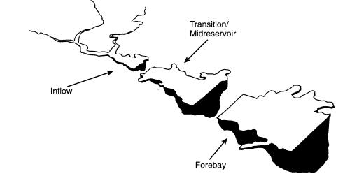
Figure 1
Key reservoir sampling areas.
Consequently, Vital Signs monitoring includes only four large embayments with drainage areas greater than 500 square miles and surface areas greater than 4,500 acres.
Locations for stream monitoring stations are chosen to sample as large a portion of each tributary watershed as possible. Stations generally are in unimpounded river reaches near the downstream end of each watershed.
Ecological Indicators
The selection of ecological indicators is tailored to the type of monitoring location. Physical, chemical, and biological indicators are used to provide information on the health of various habitats or ecological compartments. In reservoirs, the status of the open-water or pelagic area is represented by physical and chemical characteristics of water (including chlorophyll-a, a measure of phytoplankton abundance) and measurements of fish communities in midchannel. The shoreline or littoral area is evaluated by sampling the fish community. Two indicators provide information on the bottom or benthic compartment: quality of surface sediments in midchannel (chemical analysis of sediments and acute toxicity of pore water) and benthic macroinvertebrate community (10 samples collected across the full width of the reservoir at each station). In streams, all available habitats are sampled to fully characterize the station by measuring the same basic indicators used for reservoirs. For both reservoirs and streams, information from each indicator is evaluated separately, and results are then combined without weighting to arrive at an overall evaluation of ecological health.
Sampling Frequency
Sampling frequency reveals how each indicator varies over time. Physical and chemical indicators vary significantly in the short term; consequently, they are monitored monthly from spring to fall in reservoirs and every other month throughout the year in streams. Biological indicators better integrate long-term variations, and so reservoir and stream sites are sampled annually. Reservoir benthic macroinvertebrate sampling is conducted in early spring (February-April), and reservoir fish assemblage sampling is conducted in autumn (September-November). Benthic and fish community sampling in streams is conducted in late spring to early summer (May-June).
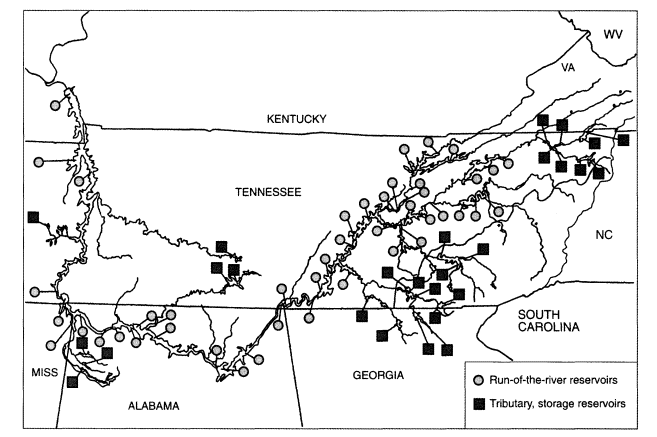
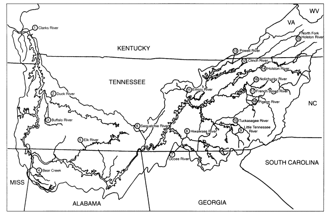
The net result of this monitoring design is that TVA collects data every year related to physical and chemical water-quality and biological conditions at sampling locations on 30 reservoirs (Figure 2) and 18 streams (Figure 3).
Aquatic Macrophytes
Aquatic macrophyte coverage is determined from large-scale (1 inch = 600 feet or 1 inch = 1,000 feet) color aerial photography taken during the late summer or early fall, which is the time of maximum submerged macrophyte growth. At approximately the same time as the over-flight, boat surveys are conducted to determine macrophyte community structure at selected sites. Using Mylar overlays attached to photographic prints, aquatic macrophyte colonies are delineated and labeled according to species, and areas are measured using an electronic planimeter. Reservoirs flown for aerial photography usually include Kentucky, Wilson, Wheeler, Guntersville, Nickajack, Chickamauga, Tellico, South Holston, and lakes in the Beech River project. For reservoirs where aerial photography is not carried out, standard field surveys and historical information are used to estimate aquatic plant community structure and coverage. Submersed aquatic plant populations generally are rare in tributary reservoirs because of the wide fluctuations of water surface elevations associated with their operation for floodwater storage. Known populations have been extremely small, short-lived, and of little significance. A detailed summary of TVA's Aquatic Plant Management Program is available in a technical report (Burns et al., 1994) that is updated and published annually.
Ecological Health Ratings
Approach
Because no official or universally accepted guidelines or criteria exist upon which to base an evaluation of ecological health, TVA developed the following methodology for rating the overall ecological health of each of the 30 TVA Vital Signs reservoirs and 18 Vital Signs stream stations. This method combines infor-
mation on physical and chemical characteristics of water quality, biological community structure, and habitat. Of the many variables it collects, TVA has selected five indicators for evaluating reservoir health: dissolved oxygen, chlorophyll-a, sediment quality, benthic macroinvertebrates, and fish community. Stream evaluation is based on four aquatic ecosystem indicators: nutrient concentrations, sediment quality, benthic macroinvertebrates, and fish community.
Ecological health evaluations depend on the ability to discriminate between good and poor conditions for each indicator. This is more easily done for streams because they offer relatively unaltered reference sites that can be examined to define ''good" conditions for each indicator. For example, various indices of biotic integrity for fish and benthic stream communities compare results at monitoring locations with conditions at reference sites (Karr et al., 1986; Kerans et al., 1992). But reservoirs are man-made alterations of natural streams; thus, no "reference reservoirs" exist for comparison. They require an alternative approach to reference conditions.
Overview
Scoring criteria for dissolved oxygen and chlorophyll-a in reservoirs are based on a conceptual model that TVA developed over several years from its experience in evaluating biological systems in reservoirs. The model for dissolved oxygen criteria for a reservoir is complicated by the combined effects of flow regulation and potential oxygen depletion in the hypolimnion (deep water). TVA's scoring criteria consider dissolved oxygen levels both in the water column and near the bottom of the reservoir. For chlorophyll-a, TVA's experience is that, below a threshold level, primary production is not sufficient to support an active, biologically healthy food chain. However, chlorophyll-a concentrations above a higher threshold result in undesirable eutrophic conditions.
For the benthic macroinvertebrate and fish community indicators, TVA based its scoring criteria on a statistical examination of multiple years of data from TVA reservoirs. All previously collected TVA reservoir data for a characteristic of a selected community (e.g., number of taxa, total abundance) are ranked and divided into good, fair, and poor groupings. The current year's results are compared with these groupings and scored accordingly. This approach is valid if the database is sufficiently large and covers the full spectrum of good-to-poor conditions.
The sediment-quality scoring criteria use a combination of sediment toxicity to test organisms and sediment chemical analyses for ammonia, heavy metals, pesticides, and polychlorinated biphenyls (PCBs).
Reservoir Scoring Criteria
Dissolved Oxygen
If only one indicator of reservoir health could be measured, dissolved oxygen (DO) would likely be the indicator of choice. Hutchinson (1975) states that a series of oxygen measurements probably provides more information about the nature of a lake than any other kind of data. The presence, absence, and levels of DO in a lake or reservoir both control and are controlled by many physical, chemical, and biological processes (e.g., photosynthesis, respiration, oxidation-reduction reactions, bacterial decomposition). DO measurements, coupled with observations of water clarity (Secchi depth), temperature, nutrients, and some basic hydrologic and morphometric information, yield substantial information about the ecological health of a reservoir.
Ideally, a reservoir has near-saturation concentrations of DO available to fish, insects, and zooplankton throughout the water column. This is usually the case during winter and spring when most reservoirs are well mixed. However, summer brings more sunlight, warmer water, and lower flows. This causes thermal stratification and increased biological activity; these combine to produce a greater biochemical demand for oxygen, particularly in the deeper portions of the reservoir. As a result, summer levels of DO often are low in the metalimnion and hypolimnion (intermediate and deepest regions). Hypolimnetic and metalimnetic oxygen depletion are common but undesirable occurrences in many reservoirs, especially storage impoundments. If DO concentrations are low enough, or low concentrations are sustained long enough, the health and diversity of the fish and benthic communities suffer. Sustained near-bottom anoxia also promotes release of ammonia, sulfide, and dissolved metals into the interstitial pore water and near-bottom waters. If this phenomenon persists long enough, these chemicals can cause chronic or acute toxicity to bottom-dwelling animals.
Historic information for reservoirs in the Tennessee Valley reveals that the burrowing mayfly (Hexagenia sp.) disappears from the benthic community at DO concentrations of 2 mg/l and below (Masters and McDonough, personal communication, 1993). Most fish species avoid areas with DO concentrations below 2 mg/l; fish growth and reproduction decrease at these levels, and many highly desirable species such as sauger and walleye simply cannot survive at such low levels of DO. Consequently, TVA considers 2 mg/l a critical level for evaluating ecological health and has incorporated it into the scheme for rating DO.
The rating scheme considers oxygen concentrations both in the water column (WCDO) and near the bottom of the reservoir (BDO). The DO rating at each sampling location (ranging from 1, "poor," to 5, "good") weights equally the average monthly summer water column and bottom water DO concentrations. Summer is defined as a 6-month period when maximum thermal stratification and maximum hypolimnetic anoxia are expected to occur (April through Septem-
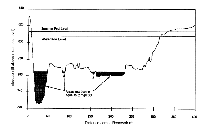
TABLE 1 Cross-Sectional Area and Length Criteria (DO less than 2 mg/l) for WCDO and BDO
|
Average Cross-Sectional Area with DO less than 2 mg/l |
WCDO Rating |
|
<5% |
5 (good) |
|
≥5% but ≤10% |
3 (fair) |
|
>10% |
1 (poor) |
|
Average Cross-Sectional Length with DO less than 2 mg/l |
BDO Rating |
|
0% |
5 (good) |
|
>0 to 10% |
4 |
|
>10 to 20% |
3 (fair) |
|
>20 to 30% |
2 |
|
>30% |
1 (poor) |
ber for the run-of-the-river reservoirs and May through October for the tributary reservoirs).
WCDO is a 6-month average of the percent of reservoir cross-sectional area at the sampling location that has a DO concentration less than 2.0 mg/l (Figure 4), and BDO is a 6-month average of the percent of reservoir cross-sectional bottom length at the sampling location that has a DO concentration less than 2.0 mg/l. The overall DO rating is the average of the DO ratings of water column and the bottom. Several criteria are used to assign numerical ratings for WCDO and BDO (Table 1).
The average percent cross-sectional bottom length is computed based on the total cross-sectional bottom length at average minimum winter pool (water-level) elevation. In addition, if anoxic bottom conditions (0 mg/l) are observed, the BDO rating for the site is lowered 1 unit, with a minimum rating of 1. In addition, because most state water-quality criteria for fish and aquatic life specify a minimum of 5.0 mg/l DO at a depth of 1.5 m (5 ft), the WCDO rating also drops if any measured DO at that depth is below 5.0 mg/l (Table 2).
Chlorophyll-a
Chlorophyll-a is a simple and well-accepted measure for estimating algal biomass, algal productivity, and trophic condition (Carlson, 1977). Too little algal productivity in reservoirs indicates an inability to sustain a well-fed, growing, balanced, and healthy aquatic community, which eventually results in low standing stocks of fish. TVA's data suggest that a mean summer chlorophyll-a concentration less than 3 jg/l is a threshold below which ecological health is impaired. But too much primary productivity often results in dense algal blooms, poor water clarity, and the predominance of noxious blue-green algae, all indica-
TABLE 2 Relationship between Variable DO(at 1.5 m) and WCDO Rating
|
Minimum DO at 1.5 m |
WCDO Rating Change |
|
<5 mg/l |
Decreased one unit (e.g., 5 to 4) |
|
<4 mg/l |
Decreased two units |
|
<3 mg/l |
Decreased three units |
|
etc. |
etc. |
tors of poor ecological health. The large amounts of algal material produced under these conditions also deplete oxygen concentrations as the algae die and decompose. This can cause or aggravate problems of low DO in bottom waters. TVA results indicate that a mean summer chlorophyll-a concentration greater than 15 μg/l is a threshold above which these undesirable conditions are likely.
These threshold levels are incorporated into the chlorophyll-a ratings at each sampling location (Table 3). The average summer chlorophyll-a concentration of monthly photic zone samples collected from April through September (or October) is compared with these criteria and rated accordingly.
Sediment Quality
Contaminated bottom sediments can have direct adverse impacts on bottom fauna and can often be long-term sources of toxic substances in the aquatic environment. Wildlife and humans may be affected by these contaminants by ingestion or through direct contact. These effects may occur even though the water
TABLE 3 Threshold Chlorophyll-a Concentrations and Corresponding Ratings
|
Average Concentrationa |
Rating |
|
<3 μg/l |
3 (fair)b |
|
3 to 10 μg/l |
5 (good) |
|
>10 to 15 μg/l |
3 (fair) |
|
>15 μg/l |
1 (poor) |
|
a If any single chlorophyll-a sample exceeds 30 mg/l, the value is not included in calculating the average, but the rating is decreased 1 unit (e.g., 5 to 4) for each sample that exceeded this value. b If nutrients are sufficient (e.g., nitrate plus nitrite greater than 0.05 mg/l and total phosphorus greater than 0.01 mg/l) but chlorophyll-a concentrations are low (e.g., less than or equal to 2 μg/l), some other limiting or inhibiting factor such as toxicity is likely. When these conditions exist, chlorophyll-a is rated 2 (poor). |
|
TABLE 4 Zooplankton Survival and Corresponding Sediment Toxicity Ratings
|
STOX rating |
Percent Survival of Ceriodaphnia and/or Brachionus |
|
5 (good) |
Survival not significantly different from control and greater than or equal to 80 percent for both species (i.e., no significant toxicity) |
|
3 (fair) |
Survival not significantly different from control, but less than 80 percent survival for either species |
|
1 (poor) |
Survival of either organism significantly less than control (i.e., significant toxicity) |
above the sediments meets water-quality criteria. TVA's approach combines two assessment methods, one biological and one chemical, to evaluate reservoir sediment quality. TVA's scoring criterion is based on ratings for the toxicity of sediment pore water (STOX) to test organisms and the chemical analysis of sediment (SCHM) for heavy metals, PCBs, organochlorine pesticides, and un-ionized ammonia. The final sediment-quality rating is the average of these two.
Sediment toxicity is evaluated using acute tests of survival of both rotifers (Brachionus calyciflorus) and daphnids (Ceriodaphnia dubia). A commercially available procedure (Rototox®) is used for the rotifer test and standard U.S. Environmental Protection Agency-approved procedures are used for the Ceriodaphnia test. These acute toxicity evaluations entail exposing these zooplankton to interstitial pore water from sediment. The survival rates of the organisms are based on the average survival in four replicates of five individuals each, compared with a control. If average survival is significantly reduced from the control, the sample is considered toxic (Table 4).
Sediment chemistry ratings (Table 5) are based on concentrations of heavy metals (Cd, Cr, Cu, Pb, Hg, Ni, and Zn) that exceed freshwater sediment guide-
TABLE 5 Sediment Chemistry Measurements and Corresponding Ratings
|
SCHM Rating |
Sediment Chemistry |
|
5 (good) |
No measurements exceed guidelines |
|
3 (fair) |
One or two measurements exceed guidelines |
|
1 (poor) |
Three or more measurements exceed guidelines |
lines (United States Environmental Protection Agency, 1977); detectable amounts of PCBs or pesticides; and concentrations of un-ionized ammonia in pore water above 200 mg NH3/l.
Benthic Community
Six community characteristics (metrics), with scoring criteria specific to either run-of-the-river or storage reservoirs, are used to evaluate the ecological health of the benthic macroinvertebrate community:
- Taxa richness, or the number of different taxa present. More taxa indicate better conditions.
- Longed-lived species, or the number of taxa of Corbicula, Hexagenia, mussels, and snails present. Because these organisms are long-lived, their presence indicates conditions that allow long-term survival.
- EPT, or the number of different taxa present within the orders Ephemeroptera (mayflies), Plecoptera (stoneflies), and Trichoptera (caddisflies). Higher numbers indicate good water-quality conditions in streams. A similar use is incorporated here despite expected lower numbers in reservoirs than in streams.
- Proportion Chironomidae, or the percent of organisms present in the sample that are chironomids. A higher proportion indicates poor conditions.
- Proportion Tubificidae, or the percent of organisms present that are tubificids. A higher proportion indicates poor quality.
- Proportion as dominant taxa, or the percent of organisms present that are members of the dominant taxon. This metric is used as an evenness indicator. A large proportion composed of one or two taxa indicates poor conditions.
Results for 10 individual bottom samples collected at evenly distributed intervals along a transect at each station are compared with criteria for each metric. Scoring criteria for each metric have been developed for both run-of-the-river reservoirs and tributary reservoirs. Because of the substantial habitat differences among reservoir forebays, transition zones, and inflows, the scoring criteria also are stratified by area. Data handling differs somewhat among the metrics. Metric 1, taxa richness, is the total number of taxa for all 10 samples at each station. Metrics 2 and 3, long-lived species and EPT, are handled similarly. For metric 4, the proportion of chironomids in each sample is calculated. The proportions are then averaged, first for the station and then for the reservoir. An alternative that was considered and rejected was to sum the number of chironomids in all samples and divide by the total number of individuals for all samples. The approach selected gives equal weight to all samples regardless of sample size or sampling gear. This eliminates the bias introduced in the alternate approach, when one sample has an exceptionally high or low density. Metric 5, proportion Tubificidae, is calculated in the same way. Metric 6, proportion as dominant taxon, is calcu-
TABLE 6 Reservoir Area Metric Scores and Corresponding Ratings
|
Sum of Reservoir Benthic Community Metric Scores |
Benthic Rating |
|
6-10 |
1 (poor) |
|
11-15 |
2 |
|
16-20 |
3 (fair) |
|
21-25 |
4 |
|
26-30 |
5 (good) |
lated similarly, using the proportion calculated for the dominant taxon in each sample, even if the dominant taxon differs among samples at a station. This allows more discretion to identify imbalances at a station than would developing an average for a single dominant taxon for all samples at the station.
The basis for evaluation criteria is the range of values found in the available database (all Vital Signs benthic monitoring data from 1991 to the present) for each metric. For each metric at each reservoir area (forebay, transition zone, and inflow) and reservoir type (run-of-the-river and tributary), the database values are divided into three groups using Ward's minimum variance analysis (SAS Institute, 1989). This procedure places observations into three homogeneous groups of approximately equal size. The groups are sorted and categorized as poor, fair, or good. Scoring criteria represent values between the highest and the lowest value in each group. The current year's results for each metric are compared with these criteria and assigned scores of 1 (poor), 3 (fair), or 5 (good) depending on which group they fall in. Scores are summed by reservoir area to yield an overall benthic rating for each location (Table 6).
Fish Assemblage
A Reservoir Fish Assemblage Index (RFAI) (Hickman et al., 1994) is used to rate fish assemblages as they relate to the overall ecological health of the reservoir. The RFAI is based on 12 metrics in 4 areas (Box 1) with scoring criteria specific to either run-of-the-river or tributary reservoirs. Scoring criteria also are specific for the type of sampling location within reservoirs—forebay, transition zone, or inflow; and for the type of sampling gear (i.e., electrofishing for littoral fish communities and gill netting for pelagic fish communities).
Each metric is assigned a score of 5, 3, or 1—representing good, fair, or poor conditions, respectively. Because of the distinct habitat differences among reservoirs and sampling locations (and the differences in the fish assemblages that they support), different scoring criteria are used according to reservoir type (run-of-the-river or tributary storage reservoirs), sampling location (forebay, transition, or inflow), and type of sampling gear (electrofishing or gill netting). There
|
BOX 1 Reservoir Fish Assemblage Index—Metric Characteristics Reservoir Fish Species Richness and Composition Metrics
|
is not yet enough information for inflow sampling locations on tributary reservoirs to establish criteria for fish community metrics at those sites.
The average of the sum of the electrofishing scores and the sum of the gill netting scores results in a RFAI for each station. The possible range of RFAI values is 12 (all metrics scored 1) to 60 (all metrics scored 5). This possible range is divided into five equal groupings to evaluate the overall health of the fish assemblage at each station (Table 7).
Discussions of the development of the RFAI and results of the fish evaluations for the 1991-1993 Vital Signs monitoring data are available in TVA technical reports (Brown et al, 1993; Hickman et al, 1994; Scott et al., 1992).
Overall Reservoir Health Determination
The methodology for evaluating overall ecological health combines the five indicators (DO, chlorophyll-a, sediment quality, benthic macroinvertebrates, and
|
Reservoir Fish Trophic Composition Metrics
Reservoir Fish Reproductive Composition Metric
Reservoir Fish Abundance and Fish Health Metrics
|
fish assemblage) into a single numeric value. To arrive at this number, the first step is to sum the ratings for all indicators by station. Given the variations in both the number of indicators monitored at each station and the number of stations per reservoir, the ratings vary from 5 to 18 for the 30 reservoirs monitored in 1993.
TABLE 7 Reservoir Fish Assemblage Index and Corresponding Ratings
|
RFAI Score |
Rating |
|
12-21 |
1 (poor) |
|
22-31 |
2 |
|
32-41 |
3 (fair) |
|
42-51 |
4 |
|
52-60 |
5 (good) |
Next, the sum of the ratings from all stations is totaled by reservoir, divided by the sum of the maximum potential ratings for each reservoir, and expressed as a percentage. This yields a possible overall health range from 20 percent (all indicators rated poor) to 100 percent (all indicators rated good) for each reservoir, regardless of the number of stations.
The scoring range then is divided into categories of good, fair, and poor ecological health, as follows:
- Ratings for run-of-river and tributary reservoirs are examined separately for apparent groupings.
- Reservoirs falling near the boundaries of the groupings are examined to establish initial break points for good, fair, and poor overall health ratings, drawing on knowledge of the historical conditions in those reservoirs.
- Those break points are then compared with a trisection of the possible overall scoring range (i.e., good-fair break point at 72 percent, fair-poor at 54 percent). Reservoirs falling near the boundaries established in both manners are examined to help adjust the break points up or down slightly to align with professional judgment.
This procedure yielded the following scoring ranges for reservoir ratings for 1993 data:
|
|
Poor |
Fair |
Good |
|
Run-of-the-river reservoirs |
<52 percent |
52-72 percent |
>72 percent |
|
Tributary, storage reservoirs |
<57 percent |
57-72 percent |
>72 percent |
These ranges are very similar to those developed in the same manner for the 1991 and 1992 results. The difference in break points for the poor-to-fair scoring ranges between the two types of reservoirs is because two storage reservoirs with known poor conditions rated slightly higher than the break point for poor rating on run-of-the-river reservoirs. Hence, that break point for tributary storage reservoirs was shifted upward to 57 percent.
Stream Scoring Criteria
A similar methodology is used to assess the overall ecological health at each stream monitoring location. Particular emphasis is given to the relationship between conditions at stream stations and their potential impact on downstream reservoirs.
The evaluations consider four indicators: total phosphorus, a measure of nutrient enrichment and potential for excessive algal productivity; sediment quality; benthic community; and fish community. At each station, each indicator is rated poor, fair, or good, with a numeric value of 1, 3, or 5, respectively. Equal
TABLE 8 Phosphorus Concentration and Corresponding Nutrient Ratings
|
Average Total Phosphorus Concentrationa |
Nutrient Enrichment Rating |
|
< 0.05 mg/l |
5 (good) |
|
0.05 to 0.10 mg/l |
3 (fair) |
|
> 0.10 mg/l |
1 (poor) |
|
a In addition, waters that receive high nitrogen concentrations in the presence of sufficient phosphorus often stimulate the growth of algae and other aquatic plants to an undesirable extent. Average nitrate plus nitrite nitrogen concentrations greater than 0.65 mg/l are high relative to most Tennessee Valley streams and result in lowering a rating from good to fair or from fair to poor. |
|
weights are given to each indicator. Scores are summed to produce an overall stream health rating ranging from 4 to 20. A station with an overall rating of 9 or less (≤ 45 percent) was rated poor; 10-15 (50-75 percent) fair; and 16-20 (80-100 percent) good.
Beginning in 1994, the sediment-quality rating was dropped from stream health evaluations. The sampling locations are areas where sediments accumulate only for very short periods, and evaluation of a 7-year data set shows that results do not significantly affect overall ratings.
Stream Nutrients
Phosphorus is most often the essential nutrient least available to plants relative to their needs in freshwater ecosystems; thus, low levels can limit algal productivity. When present in sufficient amounts and combined with sufficient nitrogen, phosphates may stimulate algae and other aquatic plant growth to undesirable levels. To prevent these conditions from developing in lakes, EPA recommends that total phosphorus concentrations not exceed 0.10 mg/l for streams or flowing waters or 0.05 mg/l at the point where streams enter lakes or reservoirs (United States Environmental Protection Agency, 1986). These guidelines are the basis for the ratings of stream nutrient enrichment (Table 8).
Stream Sediment Quality
The same methodology is used to evaluate stream sediment quality and reservoir sediment quality. The scoring criterion is based on a rating for the acute toxicity of sediment pore water to both the rotifer Brachionus calyciflorus and the daphnid Ceriodaphnia dubia , and a rating for the sediment concentrations of heavy metals, PCBs, organochlorine pesticides, and un-ionized ammonia. The final sediment quality rating is the average of these two ratings.
|
BOX 2 Benthic Community Metrics Taxa Richness and Community Composition
Trophic and Functional-Feeding Group
Abundance
|
Benthic Community
A modified version of the Benthic Index of Biotic Integrity (Kerans et al., 1992) is used to rate the condition of stream benthic communities. Twelve benthic community attributes in three areas (Box 2) are scored based on expected conditions at reference sites with water quality supportive of healthy benthic communities. Sampling effort consists of three Surber (riffle), three Hess (pool), and one qualitative sample. Metrics for EPT and intolerant snail and mussel species are computed by pooling all qualitative and quantitative samples. Total abundance is computed by pooling all quantitative samples. Metrics are computed separately for each quantitative sample at a station, then averaged by station.
The value obtained for each metric is scored poor, fair, or good (1, 3, or 5) against the best expected values for the reference sites. Scores are then summed to produce an index for each station that ranges from 12 to 60. That overall benthic community index for each stream location is classified as poor (score <30), fair (score 34-44), or good (score >45). Professional judgment is used to rate index scores between 30 and 33 as poor or fair.
|
BOX 3 Index of Biotic Integrity Metrics Stream Fish Species Richness and Composition
Stream Fish Trophic Structure
Stream Fish Abundance and Condition
|
Stream Fish Community
A modified version of Karr's (1981) Index of Biotic Integrity is used to assess the condition of the resident fish community at monitoring locations. An index and rating are produced for each site by applying the 12 metrics in Box 3.
Actual values obtained for each of these metrics are scored poor, fair, or good (1, 3, or 5) against values that would be expected at reference sites. The 12 metric scores are summed to produce an index ranging from 12 to 60, and the fish community at the stream sampling location is rated as poor (index < 36), fair (index 40-44), or good (index > 46). Professional judgment is used to rate fish community index values between 36 and 40 and index values of 45. These determinations are based on factors such as which of the 12 metrics rates poorest, the condition of the coexisting macroinvertebrate community, and previous Index of Biotic Integrity ratings for the station.
Results
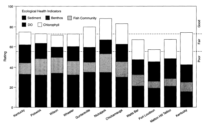
The overall ecological health ratings for the 11 run-of-river reservoirs ranged from 58 to 88 percent in 1993 (Figure 5). Of the 11 reservoirs, 4 rated good (75-
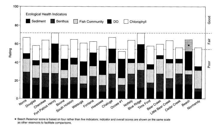
88 percent), 3 rated fair to good (71-73 percent), 3 rated fair (63-68 percent), and 1 rated poor to fair (58 percent). Overall ratings for the 19 tributary reservoirs ranged from 52 to 72 percent (Figure 6). Two reservoirs rated fair to good (both 72 percent), 14 rated fair (58-67 percent), and 3 rated poor to fair (52-56 percent).
Stream monitoring results showed a wide range of ecological conditions among the 12 streams. Three, the Clinch, Powell, and Little Tennessee Rivers, had the highest possible scores for all four ecological health indicators (nutrients, sediment, benthic macroinvertebrates, and fish community). The lowest score (50 percent) was for the French Broad River, where nutrients and fish rated poor, benthos rated fair, and sediments rated good. Scores for the remaining eight streams were evenly distributed within this range.
Most streams and reservoirs had ratings comparable to those observed in 1991 and 1992. Tributary reservoirs had generally poorer ratings than run-of-the-river reservoirs, primarily because of low DO in the hypolimnion. This is an ecologically undesirable condition that is partly due to the strong thermal stratification that occurs in deep reservoirs with relatively long retention times.
Summary
This approach to stream and reservoir monitoring has proved to be a very effective way of tracking water resource conditions throughout the Tennessee Valley. The evaluation procedure focuses on critical indicators of environmental conditions and summarizes results in easily understandable terms. The information that the program produces effectively communicates information to the public and decision makers, and the technical basis for collecting and analyzing data is readily available for those who require more detailed information. TVA distributes about 200 copies of a technical summary report each year in response to requests from other agencies and individuals. The nontechnical report targeted to lake users, property owners, and the general public is mailed to about 12,000 people who have requested it, and another 40,000 copies are distributed through marinas and other public-use areas. The public's response to these products has been overwhelmingly positive.
Each year, TVA critically reviews the results to ensure that the monitoring stations are properly located and that the evaluation scheme yields useful information. As a result of these reviews, several stations have been moved slightly to be more representative of the areas of the reservoirs being sampled, and several refinements have been made of the ecological health-rating criteria. Additional refinements are expected as more information is collected.
One area not addressed by this monitoring and evaluation scheme is the level of satisfaction attained by the people who use TVA lakes and the streams that feed them. Factors such as fishing success, shoreline vistas, ease of access, and degree of solitude experienced greatly affect the aesthetic quality of recreational
visits. The public is keenly interested in this type of information, and TVA is investigating ways to acquire it and make it available in a form similar to the evaluations of ecological health, fish consumption, and bacteriological quality.
References
Brown, A. M., G. D. Jenkins, and G. D. Hickman. 1993. Reservoir Monitoring—1992: Summary of Fish Community Results. Norris, Tenn.: Tennessee Valley Authority.
Burns, E. R., A. L. Bates, and D. R. Webb. 1992. Aquatic Plant Management Status and Seasonal Workplan—1992 . Muscle Shoals, Ala.: Tennessee Valley Authority.
Burns, E. R., A. L. Bates, and D. R. Webb. 1993. Aquatic Plant Management Program—Status and Seasonal Workplan, 1993. Muscle Shoals, Ala.: Tennessee Valley Authority.
Burns, E. R., A. L. Bates, and D. R. Webb. 1994. Aquatic Plant Management Program—Current Status and Seasonal Workplan, 1994. Muscle Shoals, Ala.: Tennessee Valley Authority.
Carlson, R. E. 1977. A trophic state index for lakes. Limnology and Oceanography 22:361-369.
Dycus, D. L., and D. L. Meinert. 1991. Reservoir Monitoring—1990: Summary of Vital Signs and Use Impairment Monitoring on Tennessee Valley Reservoirs. TVA/WR-91/1. Chattanooga, Tenn.: Tennessee Valley Authority.
Dycus, D. L., and D. L. Meinert. 1992. Reservoir Vital Signs Monitoring—1991: Summary of Vital Signs and Use Impairment Monitoring on Tennessee Valley Reservoirs. TVA/WR-92/8. Chattanooga, Tenn.: Tennessee Valley Authority.
Dycus, D. L., and D. L. Meinert. 1993a. Reservoir Monitoring—Monitoring and Evaluation of Aquatic Resources Health and Use Suitability in Tennessee Valley Authority Reservoirs. TV-93/15. Chattanooga, Tenn.: Tennessee Valley Authority.
Dycus, D. L., and D. L. Meinert. 1993b. Reservoir Monitoring—1992: Summary of Vital Signs and Use Suitability Monitoring on Tennessee Valley Reservoirs. Chattanooga, Tenn.: Tennessee Valley Authority.
Dycus D. L., and D. L. Meinert. 1994. Tennessee Valley Reservoir and Stream Quality—1993: Summary of Vital Signs and Use Suitability Monitoring, Vol. 1. Chattanooga, Tenn.: Tennessee Valley Authority.
Hickman, G. D., A.M. Brown, and G. Peck. 1994. Tennessee Valley Reservoir and Stream Quality—1993: Summary of Reservoir Fish Assemblage Results. Norris, Tenn.: Tennessee Valley Authority.
Hutchinson, G. E. 1957. A Treatise on Limnology: Vol. 1—Geography, Physics, and Chemistry. New York: John Wiley & Sons.
Karr, J. R. 1981. Assessment of biotic integrity using fish communities. Fisheries 6(6):21-27.
Karr, J. R., K. D. Fausch, P. L. Angermier, P. R. Yant, and I. J. Schlosser. 1986. Assessment of Biological Integrity in Running Water: A Method and Its Rationale. Illinois Natural History Survey Special Publication, no. 5. Champaign, Ill: Illinois Natural History Survey.
Kerans, B. L., J. R. Karr, and S. A. Ahlstedt. 1992. Aquatic invertebrate assemblages: Spatial and temporal differences among sampling protocols. Journal of the North American Benthological Society 1 (4):377-390.
Masters, A., and T.A. McDonough. April 1993. Tennessee Valley Authority, Chattanooga, Tenn. Personal communication.
Meinert, D. L., S. R. Butkus, and T. A. McDonough. 1992. Chickamauga Reservoir Embayment Study—1990. TVA/WR-92/28. Chattanooga, Tenn.: Tennessee Valley Authority.
SAS Institute. 1989. SAS/STAT User's Guide, Version 6, 4th ed., Vol. 1. Cary, N.C.: SAS Institute.
Scott, E. M., G. D. Hickman, and A. M. Brown. 1992. Reservoir Vital Signs Monitoring—1991: Fish Community Results. TVA-92/5. Norris, Tenn.: Tennessee Valley Authority.
U.S. Environmental Protection Agency. 1977. Guidelines for the Pollutional Classification of Great Lakes Harbor Sediments. Chicago, Ill.: U.S. Environmental Protection Agency.
U.S. Environmental Protection Agency. 1986. Quality Criteria for Water: 1986. EPA-44015-86-001. Washington, D.C.: U.S. Environmental Protection Agency.


