
4
Statewide Exclusionary Screening
Statewide Exclusionary Screening (SES) was the first step in the first phase of the Siting Commission's work (Figure 3.1). This process, documented in the September 1988 Statewide Exclusionary Screening Report (SESR), was designed to eliminate from further consideration areas that did not meet the regulatory requirements for a low-level radioactive waste (LLRW) disposal facility. To accomplish this goal, the Siting Commission applied certain exclusionary criteria to the entire state to facilitate more detailed studies on the more promising areas.
Screening Criteria
The Siting Commission used the following five principles to select the exclusionary criteria to be applied for SES (SESR, pp. S-3 and S-4):
- The exclusionary criteria to be applied at this stage must address conditions that are clearly prohibited in law or regulation. There can be no allowance for compensating factors.
- The criteria must address only clearly defined areas with legally established boundaries. There can be no dispute or question about the data used in defining those boundaries.
- The criteria must contain no qualifiers that require interpretation of the law or regulations. Such interpretation would require regulatory concurrence, which is contrary to the overall philosophy of this step that the criteria and results should be clear and not subject to any debate.
- The criteria should address conditions for which data are available for all areas of the state. No
- new data collection should be necessary because this is not believed to be timely or cost effective at this point in the screening process.
- The criteria should address areas that are generally large enough to appear as areas rather than points on the map and will therefore be more meaningful by reducing the area to be considered in subsequent steps.
Given these limitations, the Siting Commission selected only 5 of the 17 exclusionary criteria for the SES step. These criteria were applicable to both of the disposal methods under consideration: aboveground or belowground disposal and underground mine disposal. The specific criteria and their regulatory bases are described in Table I.1. Details of their implementation are discussed below. The Siting Commission used maps of 1:250,000 scale1 in this screening step.
Criterion 11—Ground Water Hydrology
Exclude all areas above the Long Island Aquifer, any primary water supply aquifer, or principal aquifer designated by the Department of Environmental Conservation (DEC).2
Within this criterion, primary public water supply aquifers were defined by the DEC as "highly productive aquifers presently being utilized as sources of water by major municipal water supply systems." Principal aquifers were defined as "aquifers known to be highly productive or whose geology suggests abundant potential water supply, but which are not intensively used as sources of water supply by major municipal systems at the present time" (emphasis added).
The locations of the Long Island Aquifer and 18 primary aquifers were relatively well defined, but because only a few of the principal
aquifers were identified, the majority were not considered at this stage. They were considered during Candidate Area Identification screening (see Chapter 5).
Criterion 32—Population Density
Exclude all villages, towns, cities, or unincorporated places, as defined in the 1980 decennial census or more recent census of the United States, New York State, or any political subdivision thereof performed by the U.S. Census, that have an average population density of more than 1,000 persons per square mile.
The wording of this exclusionary criterion matched the regulatory requirement for all but one issue: it did not make use of recent census data from New York State or smaller political entities. The intent was to ensure that comparable-quality data were applied throughout the state at this stage in the process by using the U.S. Census Bureau as the only source of information. For the screening, average population densities were calculated by dividing resident populations by the areal extent of cities and towns throughout the state. At this stage, villages were not considered because of their limited size. Also, the analysis of unincorporated areas was deferred because they lacked legally constituted civil divisions and their population densities required further interpretation.
Criterion 36—Federally Protected Lands
Exclude all lands protected by the Federal government, including: National Wildlife Refuge System; fish restoration areas; migratory bird reservations; National Wilderness Preservation System; National Wild and Scenic Rivers System; National Park System.
At the scale of statewide screening, only the lands in the National Wilderness System, National Wildlife Refuge System, and National Park
System were excluded. The smaller parcels of protected lands (e.g., migratory bird refuges) were excluded during later screening steps.
Criterion 38—State-Protected Lands
Exclude all lands protected by New York State, including components of: New York State Wild, Scenic, and Recreational Rivers System; fish restoration areas; State Park System; Adirondack Park; Catskill Park; municipal parks established as of 31 December 1987; wildlife management areas; game refuges; game farms; fish hatcheries; boat launches.
At the scale of the statewide screening, 159 state parks, including Adirondack Park and Catskill Park, were excluded. Many smaller parks and other state-protected lands were excluded during later stages of the process.
Criterion 41—Indian Lands
Exclude all Indian reservations and lands under jurisdiction of Indian nations.
Readily available data on the legal boundaries of Indian lands were used in this step of the screening process.
Data Sources
Table 4.1 provides a summary of the data sources for the SES. Maps or data depicting the areas to be excluded were entered into a computerized Geographic Information System (GIS).3 The actual polygonal shapes of the excluded features were used. The areas excluded
TABLE 4.1
Sources of Data Used in SES
|
Exclusionary Criterion (criterion number)a |
Source of Data Used in Screening |
|
Long Island Aquifer and primary public water supply aquifers designated by the DEC (11) |
Primary aquifers digitized from New York State Department of Health maps of primary aquifers. Long Island Aquifer defined by New York State Department of Health as the political boundaries of Nassau and Suffolk counties (SESR, p. 2-11) |
|
State parks, including Adirondack and Catskill parks (38) |
New York State Department of Transportation maps and Gazetteer (SESR, p. 2-14) |
|
National wilderness, national wildlife refuges, and national parks (36) |
Sierra Club maps, 16 U.S.C. Ch. 1132 (1985, 1988), New York State Atlas & Gazetteer, New York State Department of Transportation maps (SESR, pp. 2-12, 2-14) |
|
Cities and towns with average population densities greater than 1,000 persons per square mile (32) |
1980 census data (SESR, p. 2-12) |
|
Indian lands (41) |
New York State Department of Transportation; New York Department of State |
|
a See Appendix I. |
|
by the five criteria were computer mapped and overlaid on a map of New York State. The maps of each of the excluded features were then overlaid collectively to obtain the total excluded areas.
Screening Results
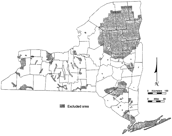
Table 4.2 summarizes the lands removed from consideration by each of the exclusionary criteria. A total of 9,669,561 acres
(approximately 30 percent of the area of the state) was excluded. The locations of the excluded lands are shown in Figure 4.1. The exclusion of state-protected lands had the greatest impact compared to all other criteria throughout the siting process. The exclusion of the Adirondack and Catskill parks, and 157 additional state parks, removed over 20 percent of the state from consideration. The area excluded by population is the second largest. Among the areas excluded were New York City, Albany, Binghamton, Buffalo, Rochester, and Syracuse. Approximately 4 percent of the state was excluded using the ground water hydrology criterion; the Long Island Aquifer constituted more than 60 percent of this area.
The majority of the excluded lands were located in the southern and eastern portions of the state (the New York City metropolitan area, Catskill Park, and Adirondack Park; see Figure 4.1). A number of smaller excluded areas were distributed throughout western New York.
TABLE 4.2
Areas Excluded by SES (after Table 4-2 of the Excluded Areas Report , New York State Siting Commission, 1993)
|
Criterion (Number) |
Acres Excluded |
Percentage of State Excludeda |
|
Ground water hydrology (11) |
1,264,219 |
4.0 |
|
Population density (32) |
1,563,142 |
4.9 |
|
Federally protected lands (36) |
< 0.1 |
|
|
State-protected lands (38) |
6,737,539b |
21.2 |
|
Indian lands (41) |
87,395b |
0.3 |
|
Total |
9,669,561 |
30.5 |
|
a Percentages computed using 31,728,640 acres as the area of New York State. b This acreage does not include parcels that were already excluded using other criteria. c This figure was incorrectly stated as 17,250 acres in Tables S-1 and 3-8 of the SESR. |
||
Public Participation
Members of the public did not have an opportunity for input into SES because the areas excluded during this process were mandated by law. They were, however, provided the opportunity to comment on the results at public meetings in October 1988 in Buffalo, Syracuse, White Plains, Potsdam, Albany, and Binghamton. At this early stage in the process, interest was not widespread. Attendance ranged from 13 persons in White Plains to more than 100 in Potsdam. The attendance in Potsdam was boosted by a rumor that the Siting Commission had selected St. Lawrence County as a potential site for an LLRW facility.
Informational materials available at these meetings included a program folder, five fact sheets, a program overview brochure, the summer 1988 issue of Frontline (the Siting Commission newsletter), the Siting Plan and executive summary, the method selection plan and executive summary, the SESR and executive summary, and the draft environmental impact statement scoping issue document. Dates and locations of meetings were advertised widely in the weeks before the meetings through public service announcements and display advertisements in newspapers.
The meetings provided a forum to inform the public about the results of the exclusionary screening, to obtain input on carrying out subsequent screening steps, and to allow input on the site and method selection plans. The public was provided an opportunity to submit written comments during a 30-day period following the meetings. The Siting Commission considered both written comments and oral presentations from the meetings in preparing its final plans. These comments were summarized in the October 1988 Public Meeting Summary Report. The subjects and numbers of comments included the following: site selection, 83; exclusionary screening, 35; method selection, 100; draft environmental impact statement, 13; program and schedule of the site selection process, 29; aid to local governments, 40; and miscellaneous programmatic comments, 120.
Analysis and Discussion
The SES step eliminated a significant portion of the state from further consideration. In the committee's judgment, the exclusions were applied appropriately and the criteria used were based on sound regulatory considerations. The committee notes that the Siting Commission had essentially no discretion in this step of the screening process: state law or regulation precluded a disposal facility from all of the excluded areas. This portion of the selection process, the removal of land areas from further consideration, was generally seen as a positive step by observers contacted by the committee.


