
Earth Observation Systems: What Shall We Do with the Data We Are Expecting in 1998?
Ralph Kahn
Jet propulsion Laboratory and California Institute of Technology
Abstract
The community of researchers studying global climate change is preparing for the launch of the first Earth Observing System (EOS) satellite. It will generate huge amounts of new data, filling gaps in the information available to address critical questions about the climate of Earth. But many data handling and data analysis problems must be solved if we are to make best use of the new measurements. In key areas, the experience and expertise of the statistics community could be of great help.
1 Introduction
The first EOS platform is scheduled for launch into polar orbit in June, 1998. It will carry five remote sensing instruments designed to study the surface and atmosphere of Earth. In a broad sense, the purpose of these observations is to find indications of how Earth's climate is changing, and to discover clues to the mechanisms that are responsible for these changes. A 5 to 15 year program of global monitoring is planned, covering many wavelengths, with spatial resolutions as small as 0.25 km and temporal coverage as frequent as daily. Higher resolution data on regional scales will also be acquired.
The surface area of Earth is about 5 × 10⁸ km2. At 0.25 km resolution, a single instrument acquiring 36 channels of data, such as the Multi-angle Imaging SpectroRadiometer (MISR) or the Moderate Resolution Imaging Spectrometer (MODIS) on the EOS platform, will generate upwards of 80 Gbyte/day, or 30 Tbyte/year of basic data. The geophysical quantities are generally retrieved at lower spatial resolution, but must include quality flags and other ancillary information, resulting in a geophysical data set that will be no smaller than 3 Tbyte/year for the MISR instrument alone.
The sheer volume of data creates unprecedented challenges for accomplishing basic data handling operations, such as throughput and storage. But there are deeper issues regarding the scientific use of this huge amount of data. The EOS community has adopted a partial framework, and some terminology, for discussing the questions we must face. However, in many areas the development of an approach to the underlying issues is in its infancy. This paper begins with a brief review of the data classification scheme we use to organize our
thinking about data handling and analysis. This is followed by discussions of some issues relating to specific classes of data, and a summary of areas to which the statistics community may be well equipped to contribute.
2 Data Classification Scheme
The Committee on Data Management And Computing define five general classes of spacecraft data, based on the degree of processing involved (CODMAC, 1982, and subsequent refinements):
-
*
Level 0 -The raw data stream from the spacecraft, as received at Earth
-
*
Level 1 -Measured radiances, geometrically and radiometrically calibrated
-
*
Level 2 -Geophysical parameters, at the highest resolution available
-
*
Level 3 -Averaged data, providing spatially and temporally "uniform" coverage
-
*
Level 4 -Data produced by a theoretical model, possibly with measurements as inputs
This paper focuses on Level 2 and Level 3 data, which are the main concerns of most global change research scientists working on EOS instrument teams. Level 2 products are reported on an orbit-by-orbit basis. For a polar-orbiting satellite such as EOS, the Level 2 sampling of Earth is highly non-uniform in space and time, with coverage at high latitudes much more frequent than near the equator. Level 2 data are needed when accuracy at high spatial resolution is more important than uniformity of coverage. These situations arise routinely for validation studies of the satellite observations, in the analysis of field campaign data, and when addressing other local-and regional-scale problems with satellite data.
The spatially and temporally uniform Level 3 data are needed for global-scale budget calculations, and for any problem that involves deriving new quantities from two or more measurements which have different sampling characteristics. To derive a Level 3 product from Level 2 data, spatial and temporal scales must be chosen. It is to this issue that we turn next.
3 Grinning and Bidding to Create Level 3 Data
The creation of Level 3 data has traditionally involved the selection of a global, 2- or 3-dimensional spatial grid, possibly a time interval as well, and "binning" the Level 2 data into the grid cells. The binning process for large data sets usually entails taking the arithmetic mean and standard deviation of all Level 2 data points failing into a grid cell, with possible trimming of outliers or of measurements flagged as "low quality" for other reasons. Typically, all points included in a grid cell average are given equal weight. Occasionally a median value will be used in place of the mean.
The leading contender for the standard EOS Level 3 grid is a rectangular-based scheme similar to one that has been used by the Earth Radiation Budget Experiment (ERBE) (Green and Wielicki, 1995a). In the proposed implementation for EOS, the Earth is divided zonally into 1.25 degree strips (about 140 km in width). Each strip is then divided into an integral number of quadrilaterals, each approximately 140 km in length, with the origin at the Greenwich meridian. This produces a nearly equal-area grid.
A number of issues arise in using a grid of this sort for the Level 3 data. Anisotropy presents an obstacle for calculating gradients, fluxes, and other quantities based on finite differences. Some neighboring cells share an edge whereas others share only a point, and there is no general rule as to how the contributions of each should be weighted. Only zonal gradients can be calculated in a consistent way on a global scale. Even in the meridional direction, the north-south cell boundaries are aligned only along the prime meridian. Inhomogeneity presents a second set of problems, since the distribution of grid cells varies with latitude, and there are singularities at the poles.
A third set of issues arises from the nesting properties of these grids. Nested grids can be used to relate data sets taken at different spatial resolutions, such as data from ground-based, aircraft, balloon, and satellite instruments. It is often necessary to compare these types of data (particularly for validation work), and to use data from multiple sources to calculate new quantities. To form sub-grids at length scales below 140 km, decisions must be made as to whether the subdivisions will be equi-angular, which are unique and relatively easy to define, or equal area, which has more desirable sampling properties, but requires more complex cell boundaries that increase anisotropy. Performing analysis on data sets from non-nested grids introduces errors that may be significant on a global scale (Green and Wielicki, 1995b), and can be arbitrarily large in regions where the quantities of interest have significant gradients (Kahn et al., 1991).
There are alternative grids, based on triangle or hexagon subdivisions of the spherical surface or a projection thereof, that may alleviate some of these issues (D. Cart and P. Huber, personal communication, MDS Workshop, 1995). A considerable body of work exists that explores the characteristics of nested systems of such grids (White et al., 1992, and references therein).
An effort is being organized to develop such grid schemes into systems that EOS scientists can use (Kiester, Kimerling, Knighton, Olsen, Sahr, and White, personal communication, 1995). A specific choice of grid system is being made, and its geometric properties characterized. Schemes will be needed to address and store data at different levels within the grid system. If the performance of a triangle or hexagon-based grid is promising, efficient translators to and from commonly used addressing systems, such as latitude-longitude, and conversions to popular map projections would need to be derived and implemented in data processing and GIS software packages widely used by the EOS community.
One would like to embed each data set into a grid within a nested system that is appropriate to its resolution and sampling structure. This raises the related issues of how to select a "native" grid size for a given data set, and how best to calculate the value and associated statistics to be assigned to each grid cell from the Level 2 data for both continuous-and discrete-valued quantities. Once this is done, methods may be developed to aggregate and dis-aggregate grids at various spatial resolutions, calculating the associated error characteristics along with the data (N. Cressie, personal communication, MDS Workshop, 1995).
Such a system would revolutionize the way the global climate research community works with data.
4 Generating Level 2 Data
The generation of Level 2 geophysical quantities from calibrated radiances introduces a far more diverse set of issues, since the retrieval algorithms vary greatly with the type of measurement made and the retrieval strategy adopted. For specificity, I use the MISR aerosol retrieval process (Diner et al., 1994) as the basis for the discussion in this section.
Two MISR-related issues similar to ones that arise elsewhere are: how to determine the sensitivity of the instrument to differences in atmospheric aerosol properties, and how to develop climatologies for the retrieved geophysical quantities based on existing constraints.
4.1 Sensitivity Studies
From the point of view of retrieving aerosol properties from MISR observations, the distinctions worth reporting are determined by the sensitivity of the instrument. We use a theoretical model to simulate the measurements at the 4 wavelengths and 9 viewing angles covered by the MISR instrument. We run simulations for a wide range of aerosol size distributions, compositions, and amounts. The full parameter space that must be explored includes mixes of particle size distributions and compositions, atmospheric relative humidity, and surface type.
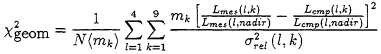
We designate the one set of simulated reflectances as the ''measured'' case, and step through "comparison" models covering a range of alternative size distributions, for example. We use simple X2 statistics to make the comparisons, such as:
where Lmes, is the simulated "measured" reflectance, Lcmp is the simulated reflectance for the "comparison" model, l and k are the indices for wavelength and viewing angle, N is the number of measurements included in the calculation, and σabs is the absolute measurement error in the reflectance. mk is the weight for terms related to viewing angle k, and <mk> is the average of the weights for all the viewing angles included in the sum.
Comparisons made in this way reduce the information content of as many as 36 individual measurements (4 wavelengths × 9 angles) to a single number. There is more information in the data. Two partly independent ways to compare cases are the maximum deviation of all the measurements used, and a X2 statistic weighted by the measurements at the nadir angle:
where σrel is the relative measurement error. We are experimenting with combinations of these metrics as the criteria to be used for evaluating the comparison cases, both in the sensitivity studies, and in the retrieval algorithm.
Our approach to covering the parameter space is also simple. We are planning first to vary particle size distribution and amount for fixed composition, establishing the minimum number of sizes needed to represent the range of expected values within the instrument sensitivity. The discrete sizes will be used to determine sensitivity to composition, which
is represented by the particle index of refraction. The sensitivity to mixtures will then be tested by a similar process.
These procedures are well-defined and systematic. But they are empirical, and it is impractical to capture every possible combination of conditions with them. In the absence of new ideas, we will live with these limitations.
4.2 Climatologies
The Level 2 retrieval algorithms for EOS must run in an automatic mode, rapidly processing huge amounts of data at computing facilities far from the purview of the instrument teams. As a first step in understanding the results, we plan to automatically compare them with" the expectations"—a climatology initially based on the best data available prior to launch.
Consider the aerosol climatology. The quantities of interest are the aerosol column amount and the aerosol "type", which summarizes particle composition, size distribution, and shape. There exist global satellite estimates of aerosol amount at 1 km resolution, over oceans only, on a weekly basis for almost seven years. For these observations, particle type is assumed. There are global models of four of the main particle types, at spatial resolutions ranging from about 100 km to about 1000 kin, at monthly or seasonal intervals. Numerous in situ measurements have also been made, with every conceivable spatial and temporal sampling. Some report aerosol amount, others provide information about aerosol type, and a few include both.
How do we merge all these data into a "climatology?" Our current approach is to ingest monthly cases of the global satellite data set into our geographic information system (GIS) as the primary constraint on aerosol amount. We will then use the global models to assign aerosol type, on a region-by-region basis (Figure 1). It is undecided as yet how the mix of particle types will be determined from the models, or how the uncertainty in the results will be obtained. We plan to use in situ measurements where available, to improve the constraints placed by the global data sets. Again we are undecided as to how to weight the information from different data sources, and how to assign uncertainties. Lastly, we must develop the algorithm that compares the aerosol properties derived from the satellite data with the climatology, and assigns a measure of "likelihood" to the result.
We will develop pragmatic approaches to each of these problems, but a formal procedure for constructing a climatology of this sort is beyond our current capability.
5 Summary of Issues
This paper concentrates on matters of potential interest to the statistics community that relate to the generation of Level 2 and Level 3 data from EOS instruments (Table 1). For Level 3 data, the main issues are: defining an effective system of nested grids, deriving procedures for ingesting Level 2 data into the system, and developing algorithms for aggregating and translating data that is in the system. Level 2 data presents a more diverse set of issues; we focused on performing sensitivity studies and developing climatologies.
The EOS community is preparing to derive geophysical quantities from measurements that will begin appearing in June 1998. All being well, we will soon face the challenges
of actually studying the data, summarizing the trends, identifying and characterizing the exceptions, and exploring the implications of the results for further data acquisition, and for global climate change... more than enough to keep several large and active communities of researchers very busy.
Acknowledgements
I thank my colleagues on the EOS MISR Team for providing the context for this work. I also thank the participants in Massive Data Sets Workshop for their interest in our data-handling issues, and their patience with our naive approach to profound problems in statistics. This work is performed at the Jet Propulsion Laboratory, California Institute of Technology, under contract with the National Aeronautics and Space Administration, through the EOS office of the Mission to Planet Earth.
References
[1] Paul R. Cohen, Michael L. Greenberg, David M. Hart, and Adele E. Howe. Trial by fire: Understanding the design requirements for agents in complex environments. AI Magazine, 10(3):32-48, Fall 1989.
[2] John D. Emerson and Michal A. Stoto. Transforming data. In David C. Hoaglin, Frederick Mosteller, and John W. Tukey, editors, Understanding robust and exploratory data analysis. Wiley, 1983.
[3] Usama Fayyad, Nicholas Weir, and S. Djorgovski. Skicat: A machine learning system for automated cataloging of large scale sky surveys. In Proceedings of the Tenth International Conference on Machine Learning , pages 112-119. Morgan Kaufmann, 1993.
[4] Michael P. Georgeff and Amy L. Lansky. Procedural knowledge. Proceedings of the IEEE Special Issue on Knowledge Representation , 74(10):1383-1398, 1986.
[5] Peter J. Huber. Data analysis implications for command language design. In K. Hopper and I. A. Newman, editors, Foundation for Human-Computer Communication. Elsevier Science Publishers, 1986.
[6] Amy L. Lansky and Andrew G. Philpot. AI-based planning for data analysis tasks. IEEE Expert, Winter 1993.
[7] Stuart Russell and Peter Norvig. Artificial Intelligence: A Modern Approach. Prentice Hall, 1995.
[8] Robert St. Amant and Paul R. Cohen. Toward the integration of exploration and modeling in a planning framework. In Proceedings of the AAAI-94 Workshop in Knowledge Discovery in Databases, 1994.
[9] Robert St. Amant and Paul R. Cohen. A case study in planning for exploratory data analysis. In Advances in Intelligent Data Analysis , pages 1-5, 1995.
| This page in the original is blank. |


