
5
DEVELOPING GOOS IN THE SPIRIT OF PARTNERSHIP
The establishment of government/research/private-sector partnerships will be critical for the development and long-term success of the Global Ocean Observing System (GOOS). There are useful examples of active partnerships of this nature in other fields (e.g., the establishment and maintenance of a global monitoring network for atmospheric chlorofluorocarbons by the Chemical Manufacturers Association).
An ongoing effort is required to identify the users and potential customers for GOOS products and services and to educate them about the benefits that could accrue. For the Marine Navigation and Coastal Hazards themes of coastal GOOS in the United States, considerable progress has already been made, which should be translated to the other themes of U.S. GOOS.
THE CONCEPT
As discussed in the 1992 National Research Council (NRC) report, Oceanography in the Next Decade: Building New Partnerships, the United States is faced with many pressing problems that would benefit from increased cooperation among government agencies, academia, and the private sector. The most commonly cited example of such a cross-cutting problem is global climate change. Successful policymaking regarding global change will be based on an adequate understanding of the earth and its systems. That understanding will be provided by collective and cooperative efforts among government agencies, academia, and the private sector. Many other challenges facing our nation and the world would benefit greatly by the type of partnerships being developed to address global climate change. A few of these successful partnerships are discussed below and are organized to reflect their ties to GOOS observations or challenges discussed in Chapter 4—Users and Benefits of GOOS.
EXAMPLES
Surface Winds
As discussed in Chapter 4, sea surface wind (SSW) products are produced from data collected from both private and government sources. Presently, basic products come from government centers, in the form of maps of SSW and digital data. An additional set of products is produced by companies in the private sector in an attempt to meet the needs of specific users.
Direct observations of wind and barometric pressure (the spatial gradients of surface pressure can be used to estimate the surface and wind) come from buoys and ships; additional remote measurements come from satellite sensors. The government maintains buoys along the coasts and some drifting buoys in the open ocean, while research programs deploy the majority of the open-ocean moored and drifting buoys. Commercial shipping participates in the Volunteer Observing Ship (VOS) system, where weather observations are collected at sea. In recent years active and passive microwave sensors on satellites launched by the United States, Japan, and other countries have provided the ability to remotely measure the surface roughness of the ocean, which is then used to estimate the surface wind.
The majority of direct wind and pressure observations and, recently, satellite wind estimates are sent in near real time via government-funded communications links to forecast centers and then are used to produce maps to the present wind field and predictions of future wind fields. Short-range forecast maps are produced, for example, for 12, 24, 36, and 72 hours into the future by some centers. Private, government, and research users use these maps to produce further products. Typically, additional interpretation and analysis are done by commercial firms to address a customer's specific needs. For example, Ocean Routes, Inc., uses wind fields to estimate wave heights and those wave heights, and winds are used to determine optimum rates for commercial shipping. Surface winds in the tropical Pacific provide another example; they are one of the key inputs to ENSO prediction models whose products, as discussed in Chapter 4, would benefit public and private sectors.
Physical Oceanographic Real-Time Systems (Ports)
In 1991 the National Oceanic and Atmospheric Administration (NOAA) introduced its first physical oceanographic real-time system (PORTS). As discussed in Chapter 4, PORTS is a data acquisition and dissemination system that provides analyses of water level, currents and other selected oceanographic and meteorological data as well as forecasts on a real-time basis to maritime users.
The system not only enhances safety but also provides information to increase the economic benefits to ports, shippers, and carriers by providing current, accurate information on channel depths and currents. Using real-time information, carriers can time their arrivals and departures to maximize their loads and efficiently utilize port facilities.
From a safety perspective, the real-time information gives ships' officers and pilots exact information about tides, currents, and wind which can be factored into the decisionmaking process when navigating a vessel through a harbor. Prior to PORTS, the information was gathered by word of mouth, historical information, or exploration.
PORTS was developed and continues to be improved through partnerships. These partnerships are composed of NOAA, port authorities, and various pilot organizations. The partnerships have been successful because NOAA had a need to improve its discovery of the data, and industry needed more timely and accurate information for both safety and economic progress.
PORTS is now installed in four port complexes: Tampa Bay, Houston-Galveston, New York and New Jersey, and San Francisco Bay. This system is an excellent example of how oceanographic data can be applied to practical uses for the safety. of ship navigation and the economic benefit of shippers.
The California Cooperative Fisheries Investigations
The University of California Cooperative Fisheries Investigations (CalCOFI) program is a consortium of state and federal agencies (including the University of California at San Diego) that supports the efforts of scientists who conduct integrated oceanographic research of the California Current. A unique aspect of the program is that it is partially funded by ultimate users (i.e., through state taxes on commercial fishery products). In addition, non-CalCOFI scientists conducting research sponsored by the Office of Naval Research and the National Science Foundation may participate in CalCOFI cruises. The data collected by these additional scientists while conducting their independent research supplements the standard CalCOFI data set. Consequently, ship resources are maximized to produce a detailed and robust description of the CalCOFI study area.
The CalCOFI program was established in 1949 to investigate factors causing the collapse of the sardine fishery off California, but over the years the scope of its research has broadened. The CalCOFI effort has produced a long-term picture of the oceanography of a 250,000-square-mile area of the Pacific Ocean off California and Baja California. The CalCOFI program has produced one of the best long-term examples of oceanographic data sets and the study area in the California Current. This is one of the few regions for which there is a long time series of archived plankton and larval fish samples. The CalCOFI program
sponsors quarterly surveys of 68 stations south of 35ºN. The current sampling pattern has been used since 1985; however, prior to 1985, a larger region was sampled.
Algal Blooms
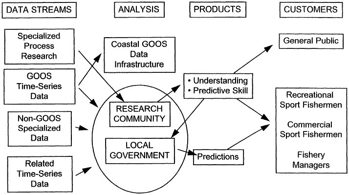
The establishment of routine, long-term, geographically widespread systems designed to help prediction of harmful or ''nuisance'' algal blooms will require a broad spectrum of partners acting as data providers, data users, and customers. In contrast with some other GOOS activities (e.g., development and production of climate-related products), non-GOOS as well as GOOS data streams will be required to produce useful products, such as bloom predictions considered.
The nature of partnerships involved in this problem is illustrated in Figure 7. In the case of the Long Island brown tide, partnerships are being established to address the problem. The motivation for tackling this problem was rooted in a request from the local community and local business organizations to identify and mitigate the factors causing brown tide blooms. The local county government established a biweekly water quality monitoring program in the affected areas that has been operating now for 11 years. Various more specialized research activities have been supported at regional universities in order to gain understanding of the conditions and organisms responsible for the blooms. These studies have been supported variously by local, state, and federal agencies.
More recently, the local county government has entered into a partnership with a nearby federal laboratory (Brookhaven National Laboratory). This partnership allows expertise and technologies developed by the Department of Energy, to be applied to this regional problem. For example, an in situ observing system designed to collect and transmit continuous measurements of T, S, 02 and chlorophyll back to shore has been deployed. Plans to have the county maintain and operate the system are under discussion. NOAA is now sponsoring a concerted research effort by the academic community into brown tide causation, and brown tide research is supported as part of the Peconice Estuary Program (a pan of the Environmental Protection Agency's National Estuary Program).
The challenges associated with brown tide have resulted in the emergence of a partnership that has increased understanding, which can be translated into productive capability. Coastal GOOS could play an important role in stimulating partnerships tackling similar problems in other regions nationwide and worldwide.
These examples of partnerships also demonstrate the need to develop coordinated observation systems within GOOS and GTOS to monitor the consequences of human activities and natural variability. One aspect of this
could include mapping of adverse and disease events in coastal zones and their impacts on floral and faunal taxa (e.g., algae, seagrass, shellfish, finfish, invertebrates, coral reefs, sea birds, sea mammals). An observing system for adverse events could be beneficial in (a) determining local ecological causes (eutrophication) and global factors (warm sea surface temperatures); (b) identifying spatial "hotspots" and temporal signals (e.g., El Niño/Southern Oscillation); and (c) helping derive economic damages ("costs") of change in global and regional systems.


