
2
Spatial and Temporal Scales for Watersheds
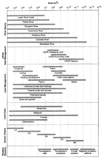
Successful strategies for the management of America's watersheds must take into account an immense range of scales in the natural environment as well as in decisionmaking. Watersheds partition the natural landscape into units ranging in size from a few square meters to more than 3 million square kilometers (1.15 million square miles) for the Mississippi River basin, and decisionmaking for their management occurs in venues ranging from neighborhood groups serving a few dozen people to the federal government, which represents the interests of more than 260 million citizens. Meanwhile, natural forces affecting watersheds also occur at a range of scales (see Figure 2.1). Effective watershed science and policy require understanding the effects that variations in scale and scope have on watershed management efforts. This chapter explores the implications of scale, scope, and structure by (1) outlining the influence of scale on both physical and human processes related to watersheds, (2) exploring connections between temporal and geographic scales of change, and (3) reviewing an established scale-based system that defines watersheds in the United States for general application.
Defining Watersheds
In general usage, the term watershed often connotes a relatively small drainage area, while the term river basin is reserved for very large areas. These terms are not scale-specific and should not be limited to particular size classes, however, because each term properly applies to regions ranging in size from less than a small field to almost a third of the North American continent. A more precise lexicon for watershed science and policy adopts specific meaning for several
terms and concepts that are often commingled: a drainage basin is a portion of the surface of the earth where all water falling on its surface collects in a network of channels and exits the watershed at a single point. The basin may terminate in a lake that has no outlet (in some arid regions), the ocean, or another larger river. Drainage basins have perimeters defined by relatively high portions of the topography that form drainage divides. The vertical projection of the basin outline onto a horizontal plane is the drainage area. Except for a few rare exceptions, the entire earth surface is divided into drainage basins. Each basin contains smaller sub-basins with their own identities, with minor interbasin areas where slopes drain directly to large channels. Drainage basins therefore have two topologic properties important to their investigation and management: they completely divide the earth's surface into naturally defined subunits, and they are also nested areas, with larger basins subsuming smaller ones (Figure 2.2).
The term watershed is now a wide-ranging label. Originally it referred only to the line of high ground separating two basins (now referred to as the interfluve), but in the twentieth century watershed came to denote the drainage area (Bates and Jackson, 1980). In general usage (if not formal definition) in the late twentieth century, watershed refers to a drainage area along with its associated water, soils, vegetation, animals, land use, and human activities.
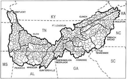
FIGURE 2.2
The watersheds of the Tennessee River basin, showing nesting of the smallest basins within larger sub-basins, all contained with the outline of the Tennessee River drainage. Modified from original map by TVA.
The defining geographic characteristic of the watershed is its topography, but it is a dynamic system with inputs, outputs, and interactive ecosystem components. An ecosystem is a distinctive collection of life forms and their physical support systems within a particular region, a concept that is a foundation in modern environmental management (National Research Council, 1994). Numerous laws and operating regulations use the ecosystem concept as a foundation for management goals that generally strive to sustain flows of goods and services for human welfare while maintaining the long-term health and integrity of the natural system (Jensen et al., 1996). Ecosystem management is difficult to put into practice because ecosystems are geographically difficult to define from a scientific standpoint, and even more troublesome from an administrative perspective because many citizens do not have a mental picture of such a system (Fitzsimmons, 1996).
The watershed, however, provides a logical boundary system and conceptual unit for ecosystem management because it is based on the geographic characteristics of the ecosystem's hydrology. It thus recognizes the dominant role that water plays in the biological relationships. In addition, a watershed is easily perceived and recognized. People understand it. From a legal perspective, watershed boundaries are more easily defined than many other boundaries in the natural environment.
Using of watershed boundaries for ecosystem management provides an advantage for measuring and monitoring of basic physical and chemical ecosystems components, since water is the fundamental transporter of nutrients through ecosystems. Each stream gauge with its measurements of quantity and chemical quality of water, specifically reveals variations in processes in the watershed that drains to it. Our understanding of geographical budgets for water, energy, and nutrients is therefore predicated on watershed outlines, and this understanding is most readily applied to management decisions on the same watershed basis. Climatic data in the United States are also organized according to major watersheds because of the importance of precipitation to runoff estimates. The National Weather Service organizes its climatic, precipitation, and drought data according to climatic regions with boundaries corresponding to watershed boundaries. Data sets for very large river basins can be constructed in additive fashion by cumulating the data for smaller climatic regions.
Although economic and social data are not intentionally collected and reported according to watershed boundaries, nearly coincidental economic and social regions can be defined at least for the large water regions of the United States. This congruity occurs because the nation's economic and social data are arranged by the Bureau of the Census according to the boundaries of more than 3,000 counties and the county boundaries in many parts of the country are partially aligned with drainage divides. Where such intentional correspondence does not occur, the mismatch is rarely so large as to be problematic. County data can therefore be aggregated into regions approximating large and medium scale water-
sheds. Agricultural data is also compatible with watershed boundaries because the Census of Agriculture (of the U.S. Department of Agriculture), reports production data and livestock populations according to counties. For smaller watersheds, census data collected on divisions smaller than counties are also available, with data aggregated according to census tracts and census blocks that have resolution to a scale equal to about four city blocks. Watershed approaches are therefore geographical perspectives that can integrate of physical, chemical, some biological, economic, and social data.
The use of watershed boundaries is less effective for wildlife and vegetation applications. Many types of ecosystems do not have boundaries determined by drainage divides, but this problem should not be detrimental to watershed approaches. For small ecosystems, vegetation patches, and limited habitats for some wildlife species, even small watersheds will completely contain the area of concern. In the case of bald eagle nesting places, for example, some watershed will contain the critical habitat, while others do not, and so the management issue will be present for some watersheds and not others. Some ecosystems are either larger than easily defined watersheds, or they span several, such as the greater Yellowstone ecosystem. In these cases, special considerations will be required to account for the overlap.
Watersheds are open systems, with mass and energy being exchanged with places outside the defined area. Groundwater, for example, migrates along groundwater gradients that do not always respect the surface configuration, so that an aquifer may transcend watershed boundaries. The hydroelectric power generated in one watershed may be conducted to distant markets, so that the consumers of that power become legitimate stakeholders in the management of the watershed of origin, even if they never see it. Water may also be diverted from the watershed of origin and transported by artificial means into neighboring watersheds. These interbasin transfers occur commonly in the United States, and they extend the interests of managers beyond the nearest drainage divide. In effect, most watersheds circumscribe areas of primary interest containing most of the environmental resources and human users, but in many cases a secondary, larger region also merits consideration, a sort of expanded shadow of the original watershed. In some cases, the watershed is not the appropriate model. Airsheds, for example, with their attending issues of air quality and visibility, define regions that do not depend on watersheds. For these issues, the watershed may not be the appropriate framework for management, and other administrative regions must be constructed.
These exceptions not withstanding, the watershed is clearly useful a scientific and administrative tool for organizing the natural and human landscape. The watershed approach provides an organizational framework that integrates natural, social, and economic components shared in a geographic area.
Geographic Scales For Watersheds
Underlying the watershed's human and biological components are the basic physical foundations of landforms, water, sediment, and chemicals (including nutrients and contaminants). The landforms of the watershed are associated either with hillslopes or channels. Hillslopes (nonchannel parts of the landscape) contribute water from runoff, sediment from erosion, and chemicals carried in solution in the water or attached to particles of sediment. The slopes serve as the platforms for human use of the watershed, ranging from agricultural to urban, and they are the primary sources of the watershed's physical constituents. The channels are conduits for water, sediment, and chemicals, with their shapes and configurations reflecting a temporary balance among mass, hydraulic energy, and geomorphology.
As assemblages of hillslopes and channels, watershed sizes have specific functions. The smallest drainage basins, ranging from a few square meters to perhaps a square kilometer, often resemble simple hillslopes in their behavior, and they are source areas for water, sediment, and chemicals. Their behavior, is heavily influenced by soil characteristics, with respect to runoff, especially because if the soils of a small watershed have a high infiltration capacity, little runoff occurs. Small basins with soils that have low infiltration capacity, either naturally or because of construction, agriculture, or urbanization experience high runoff rates and accelerated erosion, sending large quantities of sediment downstream.
Natural and human controls on hillslope and stream channel behavior can create physical changes in small watersheds over short time periods (from hours to months). Thunderstorm cells up to 3 kilometers (1.9 miles) across may completely cover a small watershed, and within an hour release literally overwhelming amounts of rainfall that cause the watershed to change its surface configuration in an hour or two. For example, the maximum recorded rainfall in the United States is 305 millimeters (12 inches) in less than an hour during a thunderstorm at Holt, Missouri, in 1947 (Dingman, 1994), but the event covered only a few square kilometers. Human controls can also radically change small watersheds, such as reshaping the surface for urban development or by managing vegetation or agricultural practices.
Intermediate-size watersheds (ranging from a few square kilometers to a few thousand square kilometers) subsuming more complex terrain systems host a larger variety of processes, because unlike the smallest watersheds they have space for temporary storage of water, sediment, and associated chemicals. These intermediate watersheds have complex slopes with space for sediment storage in their lower portions, and the channels often include floodplains as major temporary depositories for sediment. The floodplains also temporarily store water during flood events, draining their overflows back into channels after the highest stages of discharge. Intermediate-size rivers therefore experience considerable
changes and adjustments even under entirely natural conditions, and human-induced alterations can amplify these changes.
Intermediate-size watersheds and rivers are often such large enough to absorb, without adjustment, the precipitation released by individual thunderstorm cells. Frontal systems or decaying tropical storms, however, can produce enough runoff to generate widespread changes in hillslopes and channels. Erosion in some parts of the watershed may be counterbalanced by deposition of sediment in other downstream areas, so that floodplains in central and lower parts of the channel network lose or gain materials. Human attempts to control water flow begin to reach their effective limit in watersheds and rivers of this size; large dams, channel engineering, and floodplain protective works such as levees can influence the processes and results of most events short of large "50-year" or "100-year" extremes, but larger and rarer events may be beyond direct human control.
Large watersheds—those with areas greater than 10,000 square kilometers (3,860 square miles)—include extensive areas of deposition for sediment and chemicals from upstream areas. The lower reaches of their rivers include large valleys partially filled with alluvium or deltaic areas either extending into the sea or confined by valley walls in areas subjected to rising sea levels. These largest watersheds span multiple geologic and vegetation provinces and include the widest variety of land uses. They are so large that they change mostly one pan at a time rather than as an entire system, and their overall adjustments are related to global hydroclimatic changes. Human activities cannot control such systems, as evidenced by the extensive floods in the Mississippi River Basin in 1993. Despite the investment of billions of dollars in flood protection, the 1993 flood event on the Mississippi produced a river several kilometers wide in its lower reaches. The flood was remarkably similar to one observed by the Spanish explorer Hernando de Soto when he crossed the river below present-day Memphis in 1541, when the basin was essentially in its natural condition.
An important property of watersheds is that their characteristics and processes are not strictly additive. That is, measurements made on a series of small watersheds cannot necessarily be extrapolated to a larger watershed that includes the smaller ones. For example, sediment yield on a unit area basis is very different for small watersheds than large ones in the same region, because the small basins may not store sediment along their channels, while storage does occur in the larger watersheds in the form of floodplains. As a result, average measurement of sediment yield from drainage areas less than 26 square kilometers (10 square miles) in extent for the United States is 1,800 cubic meters per square kilometer (about 9 tons/acre), but for areas larger than 2600 square kilometers (100 square miles) the average yield is only 240 cubic meters per square kilometer (1 ton/acre). Many fluvial and hydrologic processes have similar connections to scale, so that measurements of small area processes may not be added together to assess the behavior of the larger sum of the areas (see Box 2.1).
|
Box 2.1 Watershed Scale and Boundaries for the Tennessee River  The Tennessee Valley Authority (TVA) is an independent federal agency created in 1933 and given responsibility for flood control, navigation development, electric energy production, natural resource conservation, and general economic development with the Tennessee River Basin. The agency seeks to manage the 652-mile long Tennessee River and its a drainage basin, which includes 125 counties in 7 states (Figure 2.2). TVA has recently increased its emphasis on water quality and had adopted the goal of making the Tennessee the cleanest and most productive commercial river system in the United States by the year 2000 (Ungate, 1996). To help accomplish this objective, TVA established the Clean Water Initiative using a watershed approach. With the concept of nested functions, TVA divided the basin into 12 watersheds named for major tributaries of the main stream. Each is divided into still smaller watersheds defined by TVA as hydrologic units (HUCs). Typical sizes encompassed by these various divisions include: |
Size Scale For Channels
Researchers and administrators often characterize the stream channels using an ordering system to describe channel topology (Figure 2.3). In the Strahler ordering system, a first-order channel is the smallest fingertip tributary that begins in a hillslope area and terminates at the confluence with another channel. A second-order stream forms where two first-order channels join; a third-order stream forms where two second order streams join; and so on. A channel changes order only when joined by another of equal order. Therefore, many second order channels are joined by numerous small, first-order tributaries without changing the order of the main stream. As a result, change in order rarely occurs in the downstream direction after the trunk stream achieves an order of six or seven. The Mississippi River in its lower reaches is probably tenth order. Investigators sometimes label a drainage basin with an order number corresponding to the highest order stream within its boundary, as in "first-order basin." Because of the geometric arrangement of stream networks, the smallest order streams are by far
For each hydrologic unit, TVA collected and reviewed aquatic resource data based on existing agency reports, U.S. Environmental Protection Agency's computerized STORET data base, TVA water quality data, aerial photography, and interviews with state and federal natural resource management agencies, local governments, county health departments, and planning commissions. TVA used these data to rate each hydrologic unit for its degree of degradation and to identify areas needing remediation. TVA also uses data from rapid bioassessments and conventional physical and chemical stream measurements to assess ecological conditions of streams. Geographic information systems (GIS) provide computerized tools for storing and analyzing the data. Assessments are action-oriented, with decisions on remediation strategies taken with the best information available, rather than waiting until all the data are available. By using an adaptive management approach, decisions can be changed to reflect new information as it develops. In this process, resource value and resource condition have separate assessments, so that a resource can be degraded but still be very valuable. A small improvement in a very valuable resource may be more desirable than a large improvement in a not-so-valuable resource. |
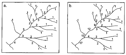
FIGURE 2.3
Two examples of stream ordering systems for a hypothetical small stream: (a) the typically used Strahler method, and (b) the more useful but less commonly applied Shreve method that shows increases in stream order more closely associated with hydrologic reality. Modified from Doornkamp and King (1971).
the most numerous (Table 2.1), and roughly represent the ''local" point of intersection between natural processes and public policy. Of necessity, the less numerous highest order streams require regional or national policy and management.
Whether applied to channels or basins, the ordering scheme provides a relative index to size or scale, but its utility is limited to description. Stream orders are mathematically related to numbers of channels, channel lengths, and drainage areas, for example, but these connections do not provide any scientific explanation of river or watershed behavior. The relationships are the geographic products of random space-filling processes, and their application is not limited to channels or drainage areas. The same mathematical relationships apply to veins in a leaf or arteries in the human circulation system, both of which can be "ordered" in the same way as a branching stream system. Stream and basin orders are firmly anchored in the geomorphologic and management literature, however, and are likely to see continued use for general descriptive purposes.
Although the properties and processes of small watersheds do not necessarily accumulate arithmetically to the larger basins that contain them, there is a clear direction of causality up the scale system. Smaller watersheds obviously influence the larger ones, but not the reverse. Watershed management may be successful for certain purposes at the small scale (for example, erosion control), and transmit changes to the larger system (for example, through changes in sediment yield). Local land-use rules in small watersheds cumulatively (but in a nonlinear fashion) influence channel behavior of the larger watersheds in which they are nested. In the reverse, however, dams and levees on large rivers have no
TABLE 2.1 Estimated Number and Length of River Channels in the United States.
|
Order |
Number |
Mean Length (mi) |
Total Length (mi) |
Mean Drainage Area (mi2) |
Example River |
|
1 |
1,570,000 |
1 |
1,570,000 |
1 |
Runway Area, St. Louis Airport, Mo. |
|
2 |
350,000 |
2.3 |
810,000 |
4.7 |
Upper Rock Creek, D.C. |
|
3 |
80,000 |
5.3 |
420,000 |
23 |
Parker River, Mass. |
|
4 |
18,000 |
12 |
220,000 |
109 |
Choptank River, Maryland |
|
5 |
4,200 |
28 |
116,000 |
518 |
Upper Iowa River, Iowa |
|
6 |
950 |
64 |
61,000 |
2,460 |
Kissimmee River, Florida |
|
7 |
200 |
147 |
30,000 |
11,700 |
Allegheny River, Penn. |
|
8 |
41 |
338 |
14,000 |
55,600 |
Gila River, Ariz. and N.M. |
|
9 |
8 |
777 |
6200 |
264,000 |
Columbia River |
|
10 |
1 |
1,800 |
1,800 |
1,150,000 |
Mississippi River |
|
Total |
|
|
3,249,000 |
|
|
|
SOURCE: Modified from Leopold, Wolman, and Miller, 1964, p. 142. |
|||||
influence on smaller watersheds upstream. Causality, like water, generally flows downstream.
Temporal Scales for Watersheds and Channels
Temporal scales also provide a framework for considering natural and human processes in watersheds (Figure 2.4). Geographic and temporal scales are closely related to each other in processes related to watersheds. The magnitudes of events in a natural environmental system are usually linked to the frequency with which they occur, with the smallest events occurring most often and the largest events very seldom. When considering any group of natural events such as floods, the smallest ones have a high probability of occurring in any given year, and the length of time between events is relatively short. The larger events and the extensive changes that accompany them have a low probability of occurring in any single year, and (on average) their return interval is relatively long. In the natural sciences, the connection between size and probability is expressed in the concepts of magnitude and frequency, which quantify particular statistical relationships (see Figure 2.5). Although the concept appears most often in hydrology, it applies equally well to events in geomorphology, meteorology, and the life sciences.
Magnitude and frequency of relationships have important implications for change in watersheds. For example, the mean maximum annual flood (the average size of the largest flood that occurs in any one year) usually remains within well-defined channels. However, floods that are larger than this reference size and that have a frequency of occurrence of less than once a year spill out of the channel and inundate the floodplain (Williams, 1978). For this reason, watershed and river management to control runoff and discharge events in channels must seek to constrain the unusual rather than the ordinary hydrologic event—a difficult task, since those events with moderate return intervals (20 to 50 years) are usually large enough to cause considerable economic damage, but are infrequent enough to be overlooked in short-term planning.
Physical factors change their roles in watershed processes depending on the temporal scale of analysis. For example, if an analyst considers watershed changes on a time scale of decades to centuries, the drainage network morphology (numbers and arrangements of channel segments) is seen as variable, subject to the influences of geology, climate, vegetation, relief, and other factors. But if the analyst considers a time span of only a year or two, the drainage network morphology is relatively unchanging, and rather than being a responding variable it is a control that influences hydraulic behavior of the stream system.
Three commonly considered time scales in geomorphology and hydrology are steady state time (years to about a decade), graded time (decades to centuries), and cyclic time (greater than a millennium). Regulators often deal with only a year or two, yet the natural processes in watersheds are better understood and
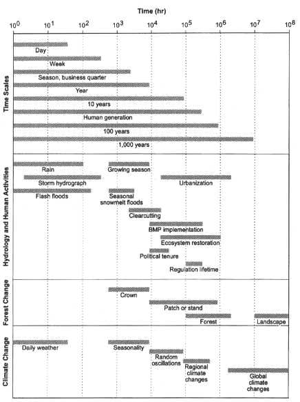
managed on at least a decade scale. As we consider increasingly long time scales, we must account for increasing numbers of variables that change within those scales (Table 2.2). At the scale most often addressed in watershed management, decades, three vital components of physical watershed systems are likely to respond as dependent variables: the drainage network morphology, hillslope forms, and the discharges of water and sediment. These three variables are most susceptible to management.
From a management perspective, the role played by each watershed variable within the temporal scale of the management effort must influence measurements and their interpretation. Depending on the time span, a variable might not be relevant, might change under the control exerted by other variables, or might change independently of other variables. Watershed problems are often detected by measured changes in dependent variables, particularly changes in the channel discharge of water or sediment. Effective watershed managers identify the independent controlling variables and try to manipulate them while recognizing that some variables are beyond human control but must be accounted for. For instance, on a one-to-ten time scale (the one managers most often encounter), the manager might manipulate primarily the runoff and sediment yield per unit area and hillslope morphology (managed by land use controls), and the drainage network morphology (managed by sewers or drains and building-site regulations), but can not respond to other controlling variables such as climate or geology.
Human action can sometimes modify natural relationships between the magnitude and frequency of watershed events. Sometimes such modifications are
TABLE 2.2 The Status of Drainage Basin Variables During Various Time Spans.
|
|
Status of Variables During Designated Time Spans |
||
|
Drainage Basin Variables |
Greater Than a Millennium |
Decade to Centuries |
Year to Decade |
|
Time |
Controlling |
Not Relevant |
Not Relevant |
|
Initial Relief |
Controlling |
Not Relevant |
Not Relevant |
|
Geology |
Controlling |
Controlling |
Controlling |
|
Climate |
Controlling |
Controlling |
Controlling |
|
Vegetation |
Responding |
Controlling |
Controlling |
|
Local Relief |
Responding |
Controlling |
Controlling |
|
Hydrology (runoff and sediment yield per unit area) |
Responding |
Controlling |
Controlling |
|
Drainage network morphology |
Responding |
Responding |
Controlling |
|
Hillslope morphology |
Responding |
Responding |
Controlling |
|
Hydrology (channel discharge of water and sediment) |
Responding |
Responding |
Responding |
|
SOURCE: Modified from Schumm and Lichty, 1969. |
|||
intentional, such as the construction and maintenance of a large dam to control the return interval of large floods. More often, however, modifications occur as unplanned and unanticipated outcomes of watershed activities. Urbanization of watersheds ranging up to about 10 square kilometers (4 square miles), with attendant installation of impervious surfaces, streets, and drains, causes floods of a given magnitude to become more frequent than under previous natural conditions. During construction in urban watersheds, previously frequent sediment discharges of small amounts temporarily become much larger before declining in magnitude again after construction. In every case, small watersheds react to both natural and human changes more rapidly than large watersheds. Thus management plans for medium to large watersheds may not have immediately visible effects. Over periods of several years or decades, however, the fruits of wise watershed management become more apparent.
Hydrologic Units
Organization of policy-making bodies along the geographic lines of watersheds is not as difficult in its conception as it is likely to be in implementation. The boundaries of the nation's drainage areas have been precisely delineated and are available in printed and digital form. During the 1970s, the U.S. Water Resources Council devised a framework for dividing the nation into water resources regions wherein all the regional boundaries are hydrologic and topographic except where blocked by international boundaries (U.S. Water Resources Council, 1978). The regions contain either the drainage area of a major river, such as the Missouri Region, or the combined drainage areas of a series of closely related rivers and their watersheds, such as the South Atlantic-Gulf Region which includes a number of watersheds draining directly into the Atlantic Ocean or the Gulf of Mexico (Figure 2.6). Note that from a hydrological view, these water resource regions do not stop at international borders, as the map implies, which complicates both policy-making and implementation efforts.
The Water Resources Council's second level of classification divides the regions into 222 planning subregions. A planning subregion includes that area drained by a river system, a reach of a river and the tributaries in that reach, a closed basin, or a group of streams forming a coastal zone. All the planning subregion boundaries are hydrologic except where discontinued at international boundaries. In 1974 the U.S. Geological Survey, in cooperation with the U.S. Water Resources Council, published maps for each state showing the locations of the boundaries, as well as a national map. A few years later during the Second National Water Assessment, the Council reclassified the 222 planning regions into 106 assessment subregions, which have hydrologic boundaries that can be approximated by county boundaries. This connection between the physical landscape and the political landscape is critical, because it eases the aggregation and analysis of both environmental and social and economic data. The primary
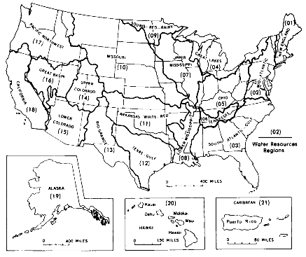
FIGURE 2.6
Map showing the water resources regions of the United States. Seaber et al., 1987.
method for collecting and collating the social and economic data is the U.S. Census, which uses counties as a basic grouping mechanism for its data. The U.S. Geological Survey uses accounting units for designating and managing the National Water Data Network. These units are a further refinement of the water resource regions based on size and hydrologic conditions. There are 352 hydrologic accounting units that nest within or are equivalent to the planning subregions.
The smallest division in the system is the cataloging unit. It is a geographic area representing part or all of a drainage basin, a combination of basins, or a distinct hydrologic feature. These 2,150 units, each with an average area of about 1,750 square kilometers (700 square miles), combine to form planning subregions and accounting units (Figure 2.7). The entire group of divisions are referred to collectively as hydrologic units, and they form a hierarchy of geographic divisions of the nation (Figure 2.8).
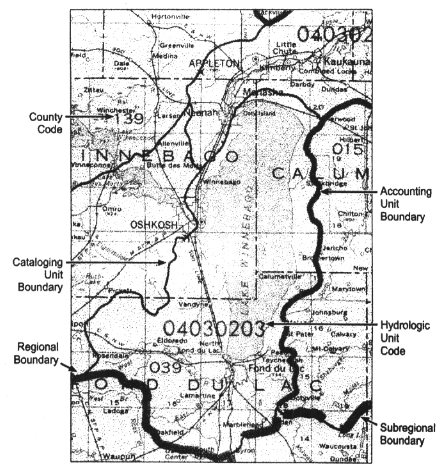
FIGURE 2.7
Section of a hydrologic unit map of a portion of north-central Wisconsin, showing the various boundaries and the association of hydrologic unit code numbers with the areas. Similar maps are available from the U.S. Geological Survey on paper or in digital format, from either the Survey or the National Resource Conservation Service. (See Appendix C for Web addresses.) SOURCE: Seaber et al., 1987.
Conclusions
Watersheds are natural topographic units of the earth's surface, usually with easily defined boundaries. The U.S. Geological Survey and U.S. Water Resources Council have defined watershed boundaries within the United States, providing a nested series of 2,150 small hydrologic units within 222 subregions, all subsumed by 21 water resource regions or large river basins. The boundaries of these units
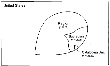
FIGURE 2.8
A schematic diagram showing the hierarchy of hydrologic units, where n = the number of units of each type in the entire nation. Data from Seaber et al., 1987.
are useful geographic delineations for ecosystems, and especially for the hydrologic components of ecosystems. In addition, much of the economic and social data collected by federal and other governments is collected in spatial units such as counties that can be often be aggregated to approximate watershed boundaries, which allows managers to further integrate ecologic, economic, and social data in their management efforts. Watershed concepts, when used in conjunction with ecosystem concepts, provide the geographic context and structure for scientific investigations and some management functions for water and water-related resources.
The consideration of scale is exceptionally important in the science and management of watersheds, and managers will be less likely to make effective use of scientific information if the scale of the information is not matched to the scale of decisionmaking. Studies of mass (water and sediment), energy, nutrients, or contaminants are not necessarily directly additive as small watersheds combine into successively larger watershed scales, because smaller systems have internal storage. Management efforts must also consider the temporal scale of the various watershed processes they seek to respond to.
References
Bates, R. L., and Jackson, J. A. 1980. Glossary of Geology. Falls Church, Virginia: American Geological Institute.
Dingman, S. L. 1994. Physical Hydrology. New York: Macmillan Publishing Company.
Doornkamp, J. C., and King, C. A. M. 1971. Numerical Analysis in Geomorphology: An Introduction. New York: St. Martin's Press.
Fitzsimmons, A. K. 1996. Sound Policy or Smoke and Mirrors: Does Ecosystem Management Make Sense? Water Resources Bulletin 32:217-227.
Jensen, M. E., Bourgeron, P. B., Everett, R., and Goodman, I. 1996. Ecosystem Management: A Landscape Ecology Perspective. Water Resources Bulletin 32:203-216.
Leopold, L. B., Wolman, M. G., and Miller, J. P. 1964. Fluvial Processes in Geomorphology. San Francisco: W. H. Freeman.
National Research Council. 1994. Review of EPA's Environmental Monitoring and Assessment Program. Washington, D.C.: National Academy Press.
Schumm, S. A., and Lichty, R. W. 1969. Time, space, and causality in geomorphology. American Journal of Science 263:110-119.
Seaber, P. R., Kapinos, F. P., and Knapp, G. L. 1987. Hydrologic Unit Maps. U.S. Geological Survey Professional Paper 2294. Washington, D.C.: U.S. Geological Survey.
Thomas, B. E., Hjalmarson, H. W., and Waltemeyer, S. D. 1994. Methods for estimating magnitude and frequency of floods in the southwestern United States. U.S. Geological Survey Open-File Report 93-419. Tucson, Ariz.: U.S. Geological Survey.
Ungate, C. D. 1996. Tennessee Valley Authority's Clean Water Initiative: Building Partnerships for Watershed Improvement. Journal of Environmental Planning and Management 39:113-122.
U.S. Water Resources Council. 1978. The Nation's Water Resources: The Second National Water Assessment by the U.S. Water Resources Council. Washington, D.C.: Government Printing Office.
Williams, G. P. 1978. Bank-full discharge of rivers. Water Resources Research 14:1141-1154.


