
Chapter Two
NOAA's Present and Proposed Coastal Ocean Buoy and C-MAN Network
We know satellites can provide SST and estimates of surface wind, sea state, and sea-level where near- or onshore features do not interfere, and radars, ship-based systems, aircraft, and other serendipitous sources of environmental observations are sometimes available, weather forecasters nonetheless rely heavily on the existing NOAA buoy/C-MAN network. The weather forecasters of the NWS hope to improve real-time observations through an expansion and redesign of that network. This chapter describes the present network and the network proposed by NOAA.
Present Coastal Ocean Buoy and C-MAN Network
The main purpose of the NOAA buoy/C-MAN network is to provide reliable, accurate, and cost-effective atmospheric and oceanic observations in support of weather forecasting, especially including the issuance of marine warnings to the general public as well as all public and private coastal interests. This network also supports international agreements on climate monitoring. NDBC oversees buoy development, deployment, and management. Beginning in the mid 1970s the first NOMAD-type buoys were deployed in the Atlantic Ocean and the Gulf of Mexico, and by 1979 a network of 26 moored-buoy stations was in existence (the C-MAN program began in 1983). Over the next decade additional moored buoys continued to be deployed by NDBC such that by 1990 the operational network of moored buoys totaled 75 stations. By 1996, this network number had declined to 69 moored buoys owing to funding problems within NOAA and other agencies that had provided earlier support for the deployment of additional buoys and C-MAN stations.
The existing distribution of approximately 1,000 land-based automated surface-observing stations supported by the NWS, the Federal Aviation Administration, and the military is shown in Figure 3. On average, over the conterminous United States there is a surface weather reporting station roughly every 50–100 km. The known spatial scale of storms suggests that,
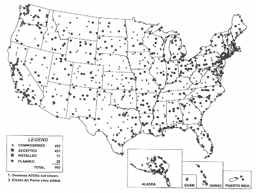
Figure 3
Distribution of the approximately 1,000 Tri-Agency (National Oceanic and Atmospheric Administration [NOAA], National Weather Service [NWS], Federal Aviation Administration [FAA], and military) Automated Surface Observing Stations (ASOS) for the conterminous United States as of 30 September 1997 including commissioned, accepted, installed, and planned ASOS stations. (Courtesy of Wendell Nuss, Department of Meteorology, Naval Postgraduate School)
in order to ensure capturing a storm's intensity and other important characteristics, observations should be made approximately every 30–50 km. While this is realistically unattainable with in situ sensors, particularly over water, it is nonetheless a standard against which surface-based observation networks should be compared. The greatest density of observations is clustered around major metropolitan areas and in coastal regions. The NWS receives data from approximately 11,000 cooperative observer (coop) stations. Figure 4 shows the locations of 7,294 of the nearly 11,000 COOP stations for which data are published by NOAA (T. Ross, personal communication, 1998). They provide information on daily precipitation and temperatures, and on the approximately 1,000 (and steadily increasing) automated mesonet stations (not shown) that report weather conditions every 5 minutes on the scale of counties (e.g., the Oklahoma mesonet).
In contrast, the current NOAA core-funded buoy/C-MAN network is
mapped in Figure 5. While station density is considerably less in the coastal waters as is readily apparent from a comparison of Figures 3 and 5, the cost of attempting to make the in situ network over water as dense as that over land is prohibitive. The existing national buoy/C-MAN network is displayed in Figure 6. In contrast to Figure 5, Figure 6 includes both the NOAA core-funded stations Figure 5 and the stations that, until recently, were funded by other federal and state agencies and private sector interests. The latter group are referred to as “unfunded” in Figure 6. Because the recently unfunded stations make up approximately one-third of the total existing network, present funding levels for the core NOAA program cannot be expected to maintain the buoy/C-MAN network in anywhere near its present configuration. In recognition of the importance of maintaining an enhanced high-caliber buoy/C-MAN network consistent with the ongoing NWS modernization and restructuring and the increased NWS responsibilities for coastal marine warnings and public safety issues, NOAA's Office of Meteorology prepared a MAROB network initiative in 1994.
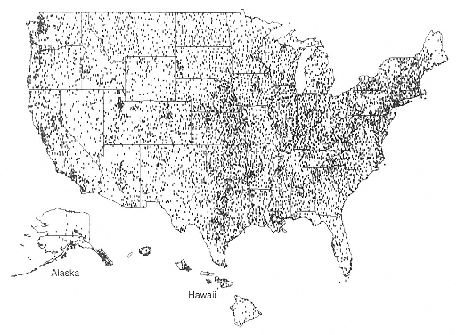
Figure 4
Distribution of approximately 7,300 of the nearly 11,000 National Weather Service (NWS) cooperative weather and climate stations that record daily maximum and minimum temperature and 24-hour precipitation amount (map current as of 30 June 1997). (Source: National Climate Data Center)
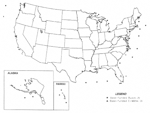
Figure 5
Current distribution of NOAA base-funded moored buoys and Coastal Marine Automated Network (C-MAN) stations across the conterminous United States.
(Source: U.S. Department of Commerce, National Oceanic and Atmospheric Administration-Marine Weather Services)
NOAA Proposal for an Improved Marine Observation (MAROB) Network
The NWS modernization and restructuring (NRC, 1991; Department of Commerce, 1997) has increased the number of field offices responsible for coastal and offshore weather services. These NWS field offices are responsible for issuing weather watches and warnings for hazardous (severe) weather to the general public and coastal marine interests. An important component of the modernized NWS coastal warning system is the network of recently deployed Doppler radars (WSR-88D) shown in Figure 7. These radars provide information on three-dimensional storm structure and movement. However, they cannot observe the offshore wind structure in the lowest part of the atmosphere below 1–2 km near the coast, and below 2–4 km more than 100 km offshore due to the effect of the Earth's curvature and the spreading of the radar beam with distance from the radar location. Because of these natural geometric effects, Doppler radars cannot observe
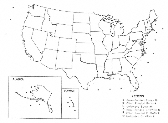
Figure 6
Distribution of existing NOAA base-funded moored buoys and C-MAN stations shown in Fig. 5 plus the additional NOAA unfunded stations that together make up the current moored buoy and C-MAN station network. (Source: U.S. Department of Commerce, National Oceanic and Atmospheric Administration-Marine Weather Services)
ocean surface winds and waves of crucial interest to operational forecasters responsible for preparation and issuance of coastal marine watches and warnings. Although it is possible to develop indirect (statistical) techniques to estimate surface winds based upon Doppler wind observations several kilometers above the ground, these statistical techniques depend upon the availability of surface observations within the radar surveillance area for development, validation, and refinement. However, the NOAA core, base-funded buoy/C-MAN station network shown in Figure 5 and the current existing station network mapped in Figure 6 are unable to provide the critical offshore weather observations needed by NWS forecasters to meet their required coastal marine warning responsibilities. Shore-based over-the-horizon radar measurement systems are being explored for use in determining wind, wave, and ocean currents (Georges and Thome, 1990; Georges et al., 1993). The few systems available are relatively costly, but they can extend the range of observation to thousands of kilometers offshore by
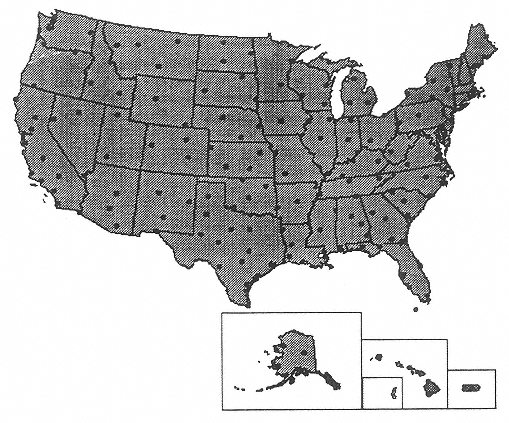
Figure 7
Operational WSR-88D Doppler radar network (NWS and military) for the conterminous United States. (Source: U.S. Department of Commerce, National Oceanic and Atmospheric Administration)
bouncing radio waves off the ionosphere. Where available, they may be able to add to the arrangement of the observing platforms.
As is readily evident from Figures 5 and 6, the existing buoy/C-MAN station network is relatively coarse. Although the existing operational network is adequate for describing weather and sea conditions on relatively large scales, it is highly inadequate for observations on smaller space and time scales (mesoscale). Important mesoscale wind and rain-bearing weather systems on spatial scales of less than 200 km and with time scales of less than 2–4 hours may develop rapidly in coastal waters and move onshore. The difficulty of monitoring offshore mesoscale weather systems is exacerbated by the relative coarseness of the present buoy/C-MAN network. Significant small-scale weather variations can be expected in coastal waters. Weather disturbances interact with coastal topography and the associated heating and cooling contrasts between land and ocean that change with the time of day and the time of year. Important mesoscale weather variations also can occur because of smaller scale differences in SST, water depth, current structure,
and the configuration of the coastline. Although it is possible to infer some information on the structure of mesoscale weather systems from satellite imagery, this information tends to be qualitative. Likewise, in many cases of hazardous weather, thick high clouds often obscure near-surface wind and sea-state signatures.
These observed mesoscale weather variations, so important to operational forecasters charged with coastal marine warning responsibilities, are inherent features of coastal storm systems. The important issue for public safety is that these features may be unresolved by the sparse existing (unfunded) network Figure 6. This point is reinforced in Figure 8, which shows the distribution of multiple agency (federal and state) weather and climate stations in central California along with the locations of NOAA moored buoys. Although the data density gradient across the central California coastline shown in Figure 8 is very large, NWS forecasters have the
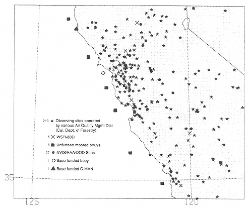
Figure 8
Distribution of multiple agency (federal and state) weather and climate stations in central California along with the locations of NOAA moored buoys and C-MAN stations over the adjacent Pacific Ocean. (Courtesy of Wendell Nuss, Department of Meteorology, Naval Postgraduate School)

Figure 9
Conterminous U.S. population density expressed as population per square kilometer by county as of 1990. (Source: U.S. Department of Commerce, Economics and Statistics Administration - Bureau of Census)
same responsibilities for issuing watches and warnings for hazardous weather both offshore and onshore. The need for coastal observations is reinforced by examination of the conterminous U.S. population density shown in Figure 9. This map reveals that the majority of the most densely populated counties are located near the Pacific and Atlantic coasts, the Gulf of Mexico, and the Great Lakes. Based on statistics from the 1990 census it is estimated that more than 50 percent of all Americans live within 100 km of a coastline.
The skewness of the observed population toward coastal regions and the need to provide timely and comprehensive coastal marine warnings for this population is the principal motivating force behind the NOAA MAROB initiative. The purpose of the MAROB network is to improve marine environmental monitoring and prediction by increasing the availability of automated marine observations along the Atlantic and Pacific coasts, the Gulf of Mexico, the Great Lakes, Alaska, near Hawaii, and near Puerto Rico and the U.S. Virgin Islands.
Marob Objectives
NOAA has established the following core objectives for MAROB:
- Environmental Monitoring—integrate with Doppler radar and satellite technology to improve detection and tracking of hazardous weather conditions over-water ranging from localized severe weather to major oceanic storms to hurricanes in order to provide more timely and precise warnings of these events;
- Modeling and Numerical Forecast Guidance—to provide a denser network of surface observations for improving forecast models of storm development and prediction of winds, waves, and storm surges;
- Warning and Forecast Verification—to provide an objective measure of the accuracy of operational warnings and forecasts and numerical forecast guidance as a means of assessing performance and identifying areas needing improvements;
- Climatology—to improve knowledge of long-term, over-water weather patterns and their local and regional variability and to establish baseline trends for climate studies;
- New Technology—to provide critical sea-truth data required for the development and validation of existing and planned new remote-sensing technology for winds, waves, and sea surface temperatures;
- Support Other NOAA Programs—to provide measurements of sea-level and shoreline change, in support of hazardous chemical spill responses, basic research in ocean dynamics and air-sea interaction, the NOAA Coastal Ocean Program, the Global Ocean Observing System, the Climate Change Program, and the modernization of NOAA's infrastructure support of all ocean programs (Marine 2000);
- Other Agency and Private Sector Applications—to provide data to other federal agencies involved in ocean-related programs and to the private sector for improved value-added information and products for client users; and
- Ocean Sentinels—to enable the NWS to disseminate critical observations and weather updates on present and expected weather and ocean conditions that, together with forecasts and warnings, will allow a wide spectrum of users to make more informed operational decisions for safeguarding life and property.
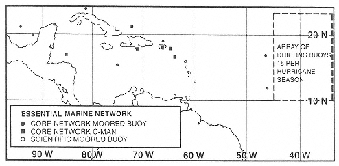
The MAROB network as proposed by NOAA is illustrated in a series of maps for the conterminous United States (Figure 10), Alaska (Figure 11), Hawaii (Figure 12), and the Caribbean and tropical western Atlantic Ocean (Figure 13). The MAROB plan adds just under 200 moored buoys and C-MAN stations to the network (above the current base-funded total of 69 C-MAN and moored buoy stations)
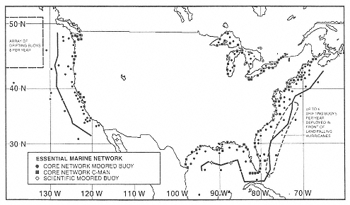
Figure 10
Marine Observation (MAROB) network as originally proposed by NOAA in the MAROB plan and as further modified in this report for the waters surrounding the conterminous United States. (Courtesy of Douglas R. Scally, National Data Buoy Center)
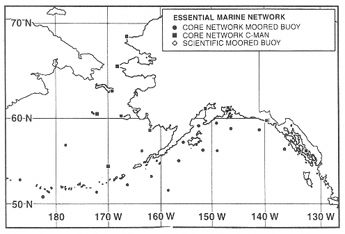
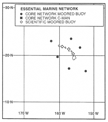
Figure 11
As in Fig. 10 except for the waters in the Alaska region. (Courtesy of Douglas R. Scally, National Data Buoy Center)
A comparison of Figures 6 and 10 shows that the proposed MAROB network represents a significant upgrade in station density relative to the existing buoy/C-MAN network. The proposed station configuration is consistent with the large coastal population density illustrated in Figure 9. Note, however, that the proposed MAROB network still would leave significant discontinuities in station density between water and land areas (see also Figure 8). Although the warning responsibilities of NWS forecasters remain unchanged across the coastlines, there are fewer data available offshore to meet warning responsibilities in an admittedly more hazardous region.
Rough calculations show that approximately $40–$50 million may be needed to manufacture the 200 new observing platforms called for under the MAROB plan. Another $4.8 million would be needed to deploy them. To maintain and operate the new platforms would require perhaps another $1.2 million each year. In addition to fixed costs, there are further costs associated with applied, technical, and engineering development. NDBC estimates that these developmental costs can range from $500,000 to $750,000 per year for the entire buoy/C-MAN network. As noted by the NDBC, developmental costs must be considered within the context of the entire network. The higher cost number of $750,000 per year is the NDBC estimate of annual development costs associated with the proposed MAROB program.


