
Chapter Three
Applications of Buoy/C-MAN Data Network
Marine Forecast Problems
The transition from a marine to a continental environment across a coastline involves changes in the air-flow pattern induced by terrain and land use characteristics and differences in temperature and atmospheric stability (NRC, 1992). The C-MAN stations help forecasters monitor unique localized conditions known to occur near coastal promontories and extending 5–10 km offshore. As discussed by Rotunno and Pietrafesa (1996), major coastline irregularities such as capes, inlets, and coastal mountains will have localized winds that can differ significantly from the general wind flow well offshore. Depending upon the prevailing wind direction, these irregularities block and deflect the flow, causing highly local circulations and channeling of the flow that can result in highly erratic local wind regimes. These erratic winds at times can act on the local sea surface to produce hazardous wave conditions that can differ significantly from the surrounding sea (Bond et al., 1997). C-MAN reporting stations also provide the first indication of the severe effects of ocean storms and hurricanes as they approach the coast based on changes in the reported wind direction and speed, temperature, and sea-level pressure. Forecasters must have knowledge of these often rapidly changing coastal weather conditions in order to provide timely and accurate warnings of high winds, storm surges, and coastal flooding associated with tropical and extratropical storms (Meadows et al., 1997; Xie et al., 1997). The winter of 1997–98 has provided ample evidence of the effect of coastal storms on island erosion and flooding and on massive beach erosion.
Coastal harbors and inlets can experience severe localized wind and wave conditions at considerable variance from reported conditions over the open ocean or inland. Contributing factors to these differences include the steepness of the coastal terrain, the shape and orientation of the coastline, sea floor topography, and underwater features such as sandbars, which can trigger eddy circulations (Bond et al., 1997; Winant and Dorman, 1997).
C-MAN buoys provide essential measurements of winds and waves within the areas of NWS marine forecast responsibility. Given that nearshore ocean currents, underwater topography, cross-shore thermal gradients, and coastline irregularity can combine to produce winds and waves that can vary on scales of tens of kilometers, forecasters must be continually alert to rapidly changing weather conditions in the coastal environment (NRC, 1992). For example, mariners often report wind speeds and wave heights that are twice those being forecast or that vary substantially over a few kilometers, even well offshore. The planned NOAA MAROB network (Figures 10 through 13) is designed to address some of these problems and to provide the forecaster a more effective and reliable coastal database on which to base the issuance of timely and accurate marine warnings. Small-scale wind and wave patterns and the timing of the onset of wind and wave conditions that reach advisory and warning thresholds are of critical importance to mariners and coastal residents. In cases of hazardous spills along the coastline, it is especially urgent that buoy/C-MAN observations be available with sufficient horizontal resolution to permit the numerical simulation of oceanic currents and surface water trajectories as guidance for spill response and clean-up teams.
Weather systems that affect western North America most often originate over the data-sparse Pacific Ocean. Buoys moored more than 250 km offshore can provide valuable early warning information on atmospheric and oceanic conditions associated with storms headed toward the coast. A combination of coastal Doppler radar precipitation, wind, and wave information; C-MAN observations near shore; moored buoy observations located well offshore; and satellite imagery provide information for NWS forecasters to improve warning lead times associated with major storms approaching the coast. Moored buoys also furnish data on large ocean swells that can originate from western Pacific typhoons or from intense extra tropical cyclones (ETCs) near Antarctica. Large ocean swells from distant storms can be especially troublesome when they mix with local wind-generated waves at the time of high tide and elevated coastal Ekman water levels to produce dangerous coastal surf conditions (Davis and Dolan, 1992). These hazardous wave conditions can result in treacherous coastal navigation conditions as well as cause coastal flooding and shoreline erosion. Hawaii is particularly at risk from dangerous wave conditions associated with distant Pacific storms. Alaska can also be subject to sea ice riding atop the elevated water levels and high waves.
During the early (late May through mid-July) and late (late September through November) parts of the Atlantic hurricane season, tropical storms frequently originate over the southwestern Gulf of Mexico (Bay of Campeche) and the western Caribbean Sea. Although this region is mostly
devoid of moored buoys, a critical need exists to monitor atmospheric conditions in these regions on a regular basis. During the middle of the hurricane season (mid-July to mid-September) tropical storms are more likely to originate from African disturbances embedded in the trade wind easterlies (10–20°N) that reach the eastern Atlantic Ocean. Drifting buoys have been used effectively to provide pressure and wind information in the trade wind easterlies (10–20°N) across the eastern Atlantic Ocean in these critical tropical storm-spawning latitudes. A coastal observation program would be shortsighted without an adaptive observation provision to deploy more drifting buoys to monitor environmental conditions in the various tropical storm regions of the Atlantic Ocean and Gulf of Mexico and to increase the number of moored buoys in the Caribbean and Gulf of Mexico. In addition to enhancing warnings for the United States, Puerto Rico, and the Virgin Islands, the buoy data (moored and drifters) would help to support hurricane warnings for the Caribbean and Central American countries as well as Mexico in fulfillment of the international responsibilities of NOAA's Tropical Prediction Center (TPC) in this area.
The buoys also contribute to a greater understanding of air-sea interaction processes under a wide variety of weather conditions, including tropical and extratropical storms and major oceanic convective outbreaks. These data can be used in the development of finer-scale regional models that can predict wind, wave, sea, and ocean thermal conditions unique to a particular coastal region. Ocean model forecast skill is dependent upon the availability of observations on sufficiently fine enough scales to reveal the complex interactions between wind-generated waves and ocean currents. Forecasters use this model guidance to get an idea of likely wind, wave, and current scenarios associated with a spectrum of tropical and extratropical storms that approach the coast. It is critical that forecasters have a chance to monitor model simulations of the atmospheric and oceanic circulations in their areas of local responsibility on a real-time basis and with the benefit of buoy observations for model verification purposes. This strategy is one important way to validate the model forecasts and to give forecasters a basis for assessing what aspects of the model forecasts are useful guidance for the issuance of coastal marine warnings, what areas require forecast improvements, and recognition of the unsolved forecast problems.
Improving Weather Forecast Models
Prospects for markedly improved prediction of disruptive weather are particularly good at this point in the history of meteorological research. Through modernization of the NWS, the nation now has access to the
advanced tools necessary for observation as well as modeling of atmospheric conditions. Meteorological buoy and C-MAN station technology extend the area over which reliable model forecast boundary and initial conditions may be determined.
Research observing capabilities are maturing to the point of operational readiness. Moreover, with recent improvements in forecast skill come increasing opportunities for adaptive observing strategies. Rapidly advancing massively parallel computing architectures already permit the computational speed necessary to adequately represent atmospheric processes in numerical models including, as necessary, the explicit representation of convection. Mathematical techniques for four-dimensional data assimilation and ensemble forecasting are increasingly practicable. Communications now afford the opportunity for instantaneous distribution of data and forecast information through broadcasts and computer-interrogated systems, such as the World Wide Web. Scientific understanding of storms and weather-related processes is now at a relatively advanced stage, and the prospects for improved understanding are excellent.
The success of numerical modeling depends on the quality of the initial and boundary data and the assimilation system, the representation of processes that occur below the level of the discretization, and the accuracy of discrete approximations to the continuous equations. Different simulation problems place different requirements on each category.
For the open ocean, and in the coastal ocean and large lakes, the surface mixed layer can respond slowly or quickly, and thus atmospheric and oceanic time and space scales can be disparate or similar over the entire spectrum of important problems. Examples abound, such as the formation of atmospheric and oceanic fronts, modification of the surface wind field, sea-state generation, hurricane track and intensity, ocean response to intense atmospheric forcing, radiation fog, mid latitude extra tropical cyclones (ETCs) genesis and coastal and estuarine storm surge, to name a few. Hence, finer-resolution data than are presently available are required. The landfall of hurricanes pose the single largest threat to the destruction of property and the associated risk of fatalities, injuries, and illness. Additionally, hurricanes at sea globally pose a major operational impediment for the U.S. Navy and other Department of Defense operations.
At present, the prediction of hurricane movement (storm track) has improved by approximately 1 percent per annum over the past 25 years (Marks and Shay, 1998). Recent research reports suggest that a significant breakthrough of up to 15 percent improvement over the last 2–3 years may have been achieved, principally through the addition of observations targeted on the hurricane environment when storms are 96–48 hours offshore
(Marks and Shay, 1998). This fact alone speaks to the value of offshore in situ observations that can be ingested into the models in real-time. Typically, upwards of 300 km of coastline must be warned and evacuated 48 hours in advance of hurricane landfall because the prediction of hurricane movement, while improved, remains uncertain. Furthermore, little skill has been demonstrated in the operational forecasts of hurricane intensity (Marks and Shay, 1998). This crucial aspect of hurricane prediction often spells the difference between the arrival of powerful winds and enormous storm surges and associated flooding with devastating property destruction or simply the arrival of a breezy rainstorm with localized high water and superficial damages (Xie et al., 1997). Evacuation to protect tens to hundreds of thousands of lives is mandatory in the first instance and entirely unnecessary in the other.
Studies related to hurricane forecasts near landfall include quantification of mechanisms associated with rapid intensity change and initialization of dynamical hurricane models with coastal radar, satellite, and at sea in situ data. Studies also include efforts to provide current analysis of storm intensity and track from satellite and radar data, to explore adaptive observing strategies for forecasts within and beyond two days, to understand the effects of coastlines and coastal mountains, and to determine the mechanisms that underlie the occurrence of localized extreme winds, rainfall, tornadoes, storm surge, and fresh water flooding.
Looking to the future, focused research may unlock secrets about hurricane dynamics and the predictability of the attendant hazards at sea and near landfall. There are early indications from preliminary research that numerical representations of the hurricane vortex in dynamical forecast models can be greatly improved, that increasingly realistic upper-ocean models can be coupled to these atmosphere models, and that the coupled model system can be used as the primary forecast tool when such models are properly initialized by a combination of continuously monitored marine buoys and targeted storm-specific observations in the atmospheric and upper ocean environments. The likely impact of such techniques, when used in combination with a denser marine observational network, observations from space, airborne observations in and near hurricanes, and of increasingly sophisticated forecast models, offer the hope of reducing the uncertainty in forecasts of hurricane track and changes in hurricane intensity. Assuming such gains are achieved, highly useful forecast information will become available with longer lead times from the Tropical Prediction Center (TPC) and NWS. Owing to the improved accuracy and reliability of these forecasts, much smaller stretches of coastline need to be evacuated and fortified in the event of an approaching storm. Less affected areas, while
alerted and able to take measured precautions, will be free to engage in commerce and business with only mild disruption. These expected forecast improvements may increase the use and value of hurricane forecasts, mainly due to greater advance notice of the need to evacuate and the reduction of coastline subjected to such extreme evacuation and fortification.
Accurate predictions of winter storm tracks and intensities have been difficult for operational meteorologists. Much of this inaccuracy arises because many of these storms traverse or originate from the particularly data sparse regions of the western North Atlantic, the western and central North Pacific oceans, and the Gulf of Mexico. This forecasting difficulty is compounded further, since the wintertime environment in which many of these systems develop along the U.S. eastern seaboard is highly baroclinic due to the proximity of the omnipresent Gulf Stream which acts to enhance the low level horizontal baroclinicity dramatically within the mid-Atlantic coastal zone (Cione, et al., 1993). This situation is especially true off the coastline of the Carolinas where, on average, the Gulf Stream is closest to land between 34–36°N. During periods of offshore flow and cold advection, low-level horizontal thermal contrasts between air temperatures at coastal stations and those immediately above the Gulf Stream can result in the rapid and intense destabilization of the marine atmospheric boundary layer within the Gulf Stream locale. This airmass conditioning or modification period often precedes wintertime coastal cyclogenesis or redevelopment.
Recently significant boundary layer improvements to operational weather forecast models have been implemented. For example, the NCEP Eta model now incorporates a complex boundary layer physics package that utilizes several vertical layers below 1 km. Nevertheless, it is difficult for any current operational numerical model to fully capture all the important fine-scale details of the mid-Atlantic coastal baroclinic zone, which during winter months is often typified by SST and air temperature gradients on the order of 10–15°C over 5–10 km within the vicinity of the Gulf Stream SST frontal zone. It is this understandable yet still problematic distinction between the averaged and highly smoothed surface data used in today's operational weather forecast models and the actual mid-Atlantic coastal zone surface conditions that most likely gives the impression that coastal cyclone intensification is not usually well represented in numerical weather prediction models.
Moreover, in the offing is a national domain full-physics mesoscale model with appropriate treatment of coastal and oceanic influences. When combined with targeted observations that are assimilated from the North Atlantic, Gulf and North Pacific, Gulf and North Atlantic regions, it will represent a major step toward improved specificity and reliability of 1–6 day
winter storm forecasts. Furthermore, better utilization of the modernized continental observing system, including WSR-88D radars and satellite derived SSTs, should improve numerical forecast deficiencies on the 1–12 hour timescale, especially over urbanized coastal zones where surface and air traffic disruptions dominate. The prediction of localized precipitation patterns, amount, type, and timing should improve, resulting in more reliable and credible forecasts of heavy rain, snow, or ice. Furthermore, it is likely that winds and large temperature swings will be indicated more precisely and with higher specificity within sub-sections of forecast zones, especially in the nation's coastal regions. The objective forecast guidance should improve enough so that many industries, governments, and individuals will alter more demonstrably their behavior with respect to specific forecasts of winter storms after they learn from experience to trust their reliability and specificity.
Presently, various forms of deep convection, many of which are organized in mesoscale convective systems are capable of giving rise to flash floods, hail, tornadoes, lightning, and microbursts. Forecasters and researchers can neither reliably predict the initiation of convection, the dissipation of mature convective systems (Emanuel and Kalnay, 1997), nor the specific regions in which severe weather will occur.
However, as more and better data become available and as numerical models improve, the primary mechanisms responsible for the initiation and dissipation of convection will be better understood. Forecast models will be better able to represent convection explicitly and to parameterize convection in ways that better represent the bulk effects of sustained, organized convection. Models will be more capable of assimilating relevant information related to a convectively disturbed initial state. Model forecasts of convection will be more reliable in a deterministic sense for periods in excess of 2 hours. In comparison to today's convective forecasts at 2 hours, detailed statistical forecast products will likely have more useful skill, perhaps for periods out to 6–10 hours. Flash floods will likely be statistically anticipated in specific watersheds for longer periods than they are now, perhaps up to 6 hours. Hailfall will be more routinely discriminated from heavy rain as a matter of course in polarimetric radar observations and perhaps be statistically predicted one day in advance in an area-wide susceptibility sense. Coastal severe weather (including possible tornado occurrences) perhaps will be forecast statistically with moderate probability over very limited areas for periods up to a few hours, as will other convectively driven strong wind events. Lightning, a serious problem in many coastal inland and offshore areas and a by-product of convection, will be more favorably bounded by forecasts of convection initiation and dissipation.
The prediction of cloud ceiling and visibility at ground level, the intensity of coastal storms, and orographic precipitation and winds are among the remaining major forecast challenges (Rotunno and Pietrafesa, 1996). For example, restricted coastal and marine ceiling and visibility routinely impede commercial and military aviation. Poor visibility also impedes transportation, most notably coastal vehicular traffic during the morning rush hour in some of our largest cities. Some of the conditions associated with impaired visibility are poorly predicted. Such conditions are often weakly forced dynamically, and are heavily influenced by microphysical and radiative processes that are not well represented in forecast models (Hirschberg, 1998).
Forecasting the intensity of precipitation, winds, and beach erosion associated with coastal cyclones is a primary objective in the United States. The forecast deficiencies are similar to that of winter storms. An important distinction for coastal storms is that the principal hazards are often rain and wind related, as in the “nor'easters” of the east coast or the “pineapple express” storms of the west coast. Both flash flooding and generalized flooding can result, and windswept surf can erode community beaches. Coastal ocean temperature and salinity structure, marine boundary layer stability, and coastal topography influence the landfalling storm intensity (Marks and Shay, 1998). Such influences are not well observed (especially the oceanic aspects), are relatively less-well understood, and are poorly initialized in limited-area forecast models.
Ceiling and visibility forecasts can be improved through explicit representation and improved parameterization of cloud processes and localized advective and radiative effects (Emanual and Kalnay, 1997). Coastal storm forecasts of precipitation and winds will improve markedly as a direct consequence of superior oceanic analyses of the initial state (Rotunno and Pietrafesa, 1996). These analysis improvements will be achieved because of observations over the upstream ocean that are targeted, as determined from baroclinic wave sensitivity criteria, and from improved knowledge of forcing conditions within the nearby coastal waters. The overall observational strategy should be both practicably necessary and realistically sufficient and will be known as the “essential program” that embodies the determination of the “best practicable mix” of observations, data assimilation schemes, and forecast models for operations extending into the next millennium. This focus is consistent with the objectives of the (NOAA-led) multi-agency thrust to develop and implement the NAOS for weather and climate monitoring. The activities required to achieve this program focus include fundamental studies to improve understanding and to develop improved parameterizations of physical processes. In addition, one must explore observa-
tional strategies, prototype instrumentation development, data assimilation techniques, and the development and refinement of numerical models. Finally, forecast demonstration projects, in a research mode, are needed to provide “proof of concept” for improved prediction capabilities and to demonstrate societal benefits.
Coastal Impacts of Severe Winter Storms and Hurricanes
The prediction of explosive oceanic cyclogenesis, close encounters with hurricanes, and hurricane landfall are examples of critical problems of great concern to marine interests and forecasters. Explosively deepening oceanic cyclones are marked by rapidly falling pressures, widespread areas of gale, storm or even hurricane force winds, large wind waves and swells, confused seas, and coastal storm surges. These storms represent a significant hazard to mariners and coastal residents alike. The sparsity of surface pressure, wind, temperature, and moisture information over the open ocean and the Great Lakes impacts both the forecast and warning process, especially during the storm development stage. The result is that warnings often underestimate the eventual storm severity and are often not issued with sufficient timeliness to enable mariners and coastal residents to take protective action for life and property. Similar problems exist with landfalling hurricanes. Although less frequent, landfalling hurricanes carry much greater potential for causing loss of life and property in coastal regions. This problem has been fully recognized by NOAA in a series of Natural Disaster Survey Reports for winter storms and landfalling tropical storms. These NOAA reports have consistently recommended that the coastal and offshore data network over the Gulf of Mexico and the Atlantic and Pacific Oceans be expanded to allow for improved prediction and warning of explosive cyclogenesis and landfalling hurricanes. A synopsis of the relevant findings and recommendations on coastal and marine observations from recent NOAA Natural Disaster Survey Reports is found in Appendix E.
Finally, we have abundant evidence that NOAA/NWS information is accessed frequently. Gilhousen (1997) noted that the posting of buoy/C-MAN observations on the Internet (http://www.ndbc.noaa.gov) by NDBC revolutionized the way these observations could be made available to public and private maritime interests. According to Gilhousen (1997), NDBC experienced almost 160,000 hits (visits, pages or files transmitted) during February 1997. Gilhousen (1997) also indicated that the NWS Forecast Office in Tallahassee, Florida (http://www.nws.fsu.edu), which has been posting NDBC observations for 2 years, has experienced between
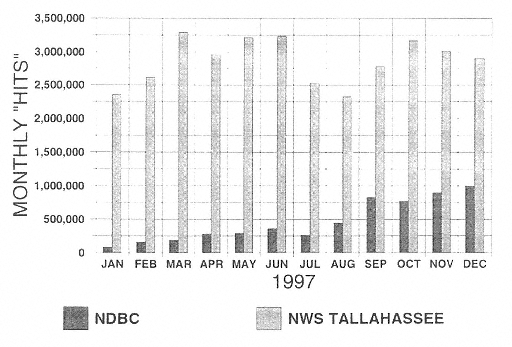
Figure 14
Monthly number of Internet visits (“hits”) for 1997 to the official web sites of the National Data Buoy Center (NDBC) and NWS Forecast Office in Tallahassee, Florida. (Courtesy of Douglas R. Scally, National Data Buoy Center)
2 and 3 million hits per month. These numbers indicate great interest in marine observations and provide additional evidence that many user communities would support efforts to improve marine observations through the enhancement of the buoy/C-MAN system. Gilhousen (personal communication, 1998) has summarized the Internet hit numbers for 1997 and his statistics are given in Figure 14.
Coastal Weather Observations, Forecasts, and Warnings
Weather forecasts and warnings in the United States are produced through a process that begins with the assimilation and error checking of a variety of surface (land and marine) and upper-air observations from around the globe. Complementary observing systems are used to build an integrated global database that is essential to describing the global wind, temperature, and moisture patterns. In addition to the buoy/C-MAN surface observations of air and water temperature, wind, waves, pressure, humidity, and other variables as needed, the global database includes surface observations with a similar suite of variables from: (1) commercial ships of oppor-
tunity and military vessels; (2) lightships; (3) drifting buoys; (4) oil and gas platforms; (5) National Ocean Survey (NOS) installations; (6) base reflectivity and base velocity observations from the Doppler radar network; (7) automated commercial aircraft temperature, moisture, and wind reports; (8) reconnaissance aircraft reports; (9) satellite-derived radiances that can be converted to vertical atmosphere temperature profiles; (10) satellite-derived precipitable water, rainfall rates, and cloud liquid water content; (11) satellite-derived cloud-drift winds at various levels in the atmosphere; and (12) satellite-derived sea-surface temperatures and scatterometer-determined surface wind estimates over the oceans. These voluminous and disparate data sources, representative of several different scales (space and time) of atmospheric and oceanic motion and thermal structure, must be assimilated into a global analysis mosaic. This data assimilation is accomplished by means of an analysis and initialization system suitable for global and regional weather prediction models of the type that are run routinely at NCEP.
Volunteer Observing Ships
Two platforms that are particularly useful in obtaining observations over much of the world's oceans are satellites in space and commercial and other volunteer ships of opportunity at sea. Ship reports are concentrated along the major global trade routes and are provided at internationally agreed upon synoptic times, typically four or eight times per day (and sometimes more frequently near major oceanic cyclones and hurricanes). It is implausible to assume that volunteer ship reports will be obtained from locations where crucial data are needed on storm structure, movement, and intensity. Ironically, as NCEP model performance on predicting cyclones continues to improve, the likelihood of obtaining valuable ship observations near storms will decrease because the ships will deviate from their predetermined courses to avoid the worst of the storms. The reliability of warnings and forecasts suffers from this irregular availability of ship data. Similarly, the reliability of ship-reported wind, wave, and swell observations are subject to wide variation, especially at night, because these observations are made visually by observers with vastly different training.
The real value of observations from commercial and other volunteer ships of opportunity lies in their ability to sample vast stretches of ocean on synoptic scales (approximately 1,000 km) where the cost of operating and maintaining fixed observational platforms, such as deep-water moored buoys, would be prohibitive. As storms approach within a few hundred kilometers of the coast, a higher data quality, consistency, and spatial resolution are
required in order to provide accurate forecast information and sufficient warning lead times to the general public and coastal marine interests. Hence, mobile ship weather reports are no substitute for a fixed array of C-MANs and moored buoys providing consistent and continuous measurements of the basic state atmospheric (i.e., pressure, temperature, winds, and moisture) and oceanic (i.e., SSTs, significant wave heights, periods, and directions) variables.
Model forecasts of wind, temperature, significant wave heights, relative humidity, and precipitation, among other variables, along with derived statistical-dynamical guidance products from these models, are examined by operational meteorologists at various NWS offices across the United States several times daily. Forecasters charged with the responsibility for preparing forecasts and issuing warnings to the general public, interested federal, state and local agencies, and public safety officials scrutinize and interpret the model forecasts. They compare them against all available observations (e.g., local and regional surface and radar observations and satellite imagery) to fine tune the model forecasts based on local and regional influences not specifically included in the models (e.g., complex coastal terrain effects that can affect the distribution of flooding, such as along the California coast and behind east coast barrier islands). This “end-to-end” forecast process, whether applied to aviation, public, fire, weather, or marine forecasts, depends critically upon the first step in the process: the acquisition of observations from a functional and representative database. For the marine community, this database is heavily dependent upon the availability of fixed observations taken at buoy/C-MAN sites and observations routinely reported by ships of opportunity and military vessels.
Space-Based Satellite Platforms
In the past three decades remarkable progress has been made in remote sensing and in the capabilities of space technology to aid in the study and understanding of Earth processes in general and the weather in particular. Emanuel and Kalnay (1997) provide an excellent overview of remote sensing capabilities, applications, and limitations.
While the extensive suite of satellite measurements and instruments is of great value for weather forecasting, there are serious caveats related to remote sensing. First, it is known that measurements made by satellite sensors are usually only indirectly related to the geophysical parameter of interest. Temporal and spatial variability in atmospheric aerosols and water vapor and variability in sea-surface roughness not related to wind, for example, introduce errors and uncertainties into the satellite estimates of such oceanic
parameters as SST, wind stress, and sea-surface elevation. Improvements to the algorithms that relate the satellite measurements to the parameters of interest must be pursued and the accuracy of the satellite measurements must be demonstrated before conventional observations are reduced or retired in favor of spaceborne observations.
Most satellite estimates will always require coincident direct-surface and upper-air measurements to perform the ongoing task of calibration, and surface platforms will be needed to make measurements not possible by remote sensing. The best determinations of the geophysical fields of interest will be obtained by combining satellite and direct measurements, blending the unmatched spatial coverage of satellite sensors with direct observations of greater accuracy or more direct connection to the geophysical parameters of concern. Therefore, a well-chosen network of direct observations will become more, not less, important as satellite techniques advance.
A network of reliable, accurate surface observations is required to reduce such errors in the Volunteer Observing Ships (VOS) network and satellite data sets to acceptable levels and will be required for the foreseeable future. Here, oceanic drifters have a role to play as well. Next, spatial fields of sea-level are very useful for validation of ocean models and for an integral constraint on initialization. Presumably the cadre of space-based altimeters could provide this information. However, the frequency of transits (e.g., for polar orbiting satellites) is such that the coverage is not necessarily synoptic in the temporal weather sense. In addition, altimeter data in the regions of ocean margins are suspect because of deficiencies in uncertainties of the geoid. Accurate measurements of sea-level are best provided by a combination of long-term altimeters where time differencing techniques can be used in combination with in situ data from the coastal tide gauge network. In the atmosphere, there is little information about boundary layer structure, especially in the divergent trade cumulus regions, which tend to lie in oceanic regions without upper air observations. Since the ability of models to simulate and assimilate near surface data depend on boundary layer processes, this is a serious gap which again is best addressed by both satellite, coastal radar, drifter and marine buoy and C-MAN data.
Space-based observations of the surface wind field have only recently become available from a number of sources. Since mid-1987, surface wind-speed information has been available from the passive microwave sensors of the Defense Meteorological Satellite Program's Special Sensor Microwave Imager (SSM/I) satellite. Global coverage at 35-km resolution is achieved approximately every 3 days. A second similar satellite, thereby providing twice the sampling, was launched in late 1991. NCEP is presently considering the inclusion of SSM/I wind speeds into its analysis and forecast sys-
tem. Since July 1991, wind velocity observations have been available from the Earth Remote Sensing (ERS-1) satellite's active microwave scatterometer. These vector wind data are now being evaluated for implementation at the European Centre for Medium Range Weather Forecasts (ECMWF). The National Aeronautics and Space Administration (NASA) scatterometer, launched in 1996, permitted the construction of gridded 12-hourly-fields of wind velocity with 50-km resolution (the satellite failed in 1997). However, both the active and passive microwave instruments suffer from a degraded signal below wind speeds of 3 m s-1. For the purpose of constructing a wind stress forcing function, conversion of the wind velocity observations still requires measurement of humidity, SST, and surface air temperature in order to calculate the stability-dependent drag coefficient. While satellites measure SST several times daily at most locations under cloud-free conditions and wind speeds, buoys measure SST, air temperature, wind speeds, and direction continuously. These buoy data and ship reports are more suitable for estimating wind stress, with satellite data used to fill in spatial voids.
In general, advanced satellite remote wind sensors such as radar scatterometers, radar altimeters, and passive microwave sensors, lack the sensitivity to resolve winds above about 20 m s-1, which means that remote sensors are able to resolve the intensity of extra tropical cyclones (ETCs) and tropical cyclones (TCs) only up to Category 1 on the Saffir-Simpson scale. In situ sensors are needed to correctly resolve the intensity of storms of greater intensity. Satellite spatial resolution is an overall problem, where gradients are often missed and land-sea boundaries are sharply defined and averaged are radiances subsequently meaningless. Space-based sensors also cannot measure surface air pressure.
In general, the VOS SST retrievals are accurate only to about 1.0°C. This accuracy may be improved by using more expendable bathythermographs (XBT), but may also require changes in equipment and methods. The most accurate real-time SST data sets are from drifting and moored buoys. NCEP now relies heavily on buoy data, not only where VOS data are lacking but also to affect quality control of VOS data from well-traveled shipping lanes. The best-resolved SST products in space and time now use techniques that combine Advanced Very High Resolution Radar (AVHRR) data with other data. For example, the joint use of AVHRR and drifter data has been shown to be accurate within ± 0.3°C. The NCEP SST field is now produced by using the buoy data to remove large-scale biases and trends in the AVHRR fields and to screen the VOS observations. Then, the smaller-scale curvatures of the field are established by the AVHRR data, and all data are objectively blended to yield an SST map.
There remain some significant and fundamental physical questions about the meaning of SST, since boundary processes, diurnal variations, and skin effects can lead to differences on the order of several tenths of a degree in the top meter or so of the ocean. It is not obvious that model parameterizations or measurements should be cast in terms of a single SST variable or, if a single variable is used, how it should be defined and observed. From the standpoint of direct observations, the SST is a central independent variable in bulk formula methods for determining air-sea heat flux, while from a large-scale modeling standpoint the SST (really the heat content in a thick near-surface layer in most models) is the key variable with which to gauge the evolution of the coupled atmosphere-ocean system. From both standpoints it is important to understand the relationship(s) of the SST (really the near-surface temperature profile) to the derived quantities-fluxes and time evolution of a model layer. This problem and many of the other SST issues noted above are discussed in a recent report (Joint Oceanographic Institute, 1992).
Together with surface wind stress and SST, the field of upper-ocean thermal structure is central to the successful initialization of coupled atmosphere-ocean models. The XBTs, taken in large part from ships of the VOS network are the primary source of global upper-ocean thermal data. However, only a small fraction of the VOS fleet operates XBTs and the data in fact are inadequate to generate monthly maps of upper-ocean thermal structure, and only bimonthly maps can be constructed.
In the context of seasonal to interannual prediction, sea-level observations are useful as an integral constraint on model initialization fields and as a model validation data set. Space-based techniques (e.g., GEOSAT and, more recently, the ERS-1 and the Ocean Surface Topography Experiment [TOPEX]/Poseidon altimeters) will yield routine global sea-level maps, but surface observations should be maintained until the need for them has been demonstrably superseded. The ERS-1 and TOPEX/Poseidon missions will afford a good opportunity over the next several years to demonstrate the utility of altimetry. Beyond the demonstration of utility lies the question of future continuity of a series of altimetric missions with instruments of known accuracy.
This discussion also raises the issues of data management, user access, quality control, and data continuity. Observations do little good unless the resulting data are accessible and the user is confident that the accuracy, influencing factors such as type of instrument and exposure, and quality control over the period of record are known. Furthermore, for an ever increasing number of applications, these data are needed over decades and longer periods with due consideration given to “comparability of record” over the duration of such records.


