
Chapter Five
Proposed Core Network and Recommendations
The existing buoy/C-MAN systems provide critical observations to forecasters in a variety of hazardous weather conditions. When NWS forecast offices in the western region issue coastal marine warnings, the primary reason for the issuance of these warnings are observations received from the buoy/C-MAN network. This warning strategy remained true even after the operational deployment of Doppler radars (WSR-88D) along the coast in the early years of this decade. Because of the curvature of the earth, the preferred siting of the radars in the coastal mountains and operational requirements that limit the lowest elevation angle of the center of the radar beam to 0.5 degrees above the horizon, coastal radars may not fully detect offshore weather systems of critical interest to mariners and coastal interests. The only reliable way for forecasters to monitor rapidly changing offshore and coastal weather conditions in order to issue timely and accurate warnings of hazardous weather is through data received from the buoy/C-MAN network.
There has been a very rapid growth in the number of individuals and groups in the marine community who regularly use real-time data from the existing buoy/C-MAN stations. This user growth has been especially rapid since the NWS and NDBC started making real-time observations from the buoy/C-MAN stations available over the Internet. The marine forecasting service needs of these users could not have been readily anticipated, even as recently as 2 years ago. Internet users, ranging from fishermen to recreational boat owners, to public safety officials increasingly require access to the basic buoy/C-MAN observations (e.g., wind direction and speed, temperature, wave height and direction, swell period) for making independent decisions in pursuit of their daily livelihoods and public duties and responsibilities. People from all walks of life have become increasingly sophisticated users. They have learned how to work with the basic data for their own purposes. In doing so, they have become dependent upon the availability of reliable real-time marine observations. The failure or withdrawal of existing buoys has raised concern in the marine data user community as
attested to by the avalanche of unsolicited letters that have been received by the principal investigator and NRC staff preparing this report, pleading for the repair, restoration, or addition of buoy/C-MAN stations.
This report concludes that a core (platform and attached suite of instrumentation) buoy/C-MAN network is required to support essential operational nowcasts, forecasts, and warnings by the modernized and restructured NWS.
Proposed Core Buoy/C-MAN Network
The rapidly increasing U.S. coastal population is particularly vulnerable to the disruptive effects of coastal flooding, storm surges, intense extratropical storms, and TCs, and it therefore depends on accurate and timely warnings of severe weather. Coastal weather forecasters at NWS rely extensively on the data provided by the NOAA operated buoy/C-MAN network. Researchers also depend on the buoy/C-MAN network for data that will lead to better understanding of storm characteristics and improved forecasts.
In 1995 NWS issued a MAROB plan for the enhancement of a core network of buoy/C-MAN installations that would be commensurate with the modernized and restructured NWS. The MAROB plan was based on the concept that the observational data density coverage from buoy/C-MAN locations had to be increased in recognition of the growing marine (coastal and offshore) responsibilities of the modernized and restructured NWS and the explosive population growth within 100–200 km of the coasts over the past two decades. This report accepts the general elements of the MAROB plan. Modifications are suggested to ensure a fully functional buoy/C-MAN network that is consistent with operational needs and requirements of NWS, but also addresses the legitimate data needs of the scientific community. The philosophy underlying the modernized and restructured NWS is that operations and research are inextricably linked. This philosophy also governs the USWRP. Improvements in weather forecasting and warning capabilities arise because of increased scientific understanding that comes from the analysis and diagnosis of weather and climate events using operational data sets and from modeling studies using these same data sets.
Recommendation #1:
A core, base-funded buoy/C-MAN network should be established and maintained.
Such a core network could be based on the 1995 MAROB plan. Any plan for the buoy/C-MAN network should take into account the following three specific characteristics:
- the addition of moored buoys around Hawaii, the eastern Pacific, Gulf of California, Gulf of Mexico, the Atlantic coast, and the Caribbean with locations to be determined on the basis of operational and research requirements;
- an increase in the use of adaptive data gathering strategies that will allow for the deployment of additional drifting buoys in the central tropical Atlantic during the hurricane season and over the open ocean waters when the potential exists for severe ETCs to threaten coastal regions; and
- the replacement of some C-MAN systems by moored and drifting buoys in areas where the C-MAN sites are situated close to nearby land-based coastal surface observation sites.
The NOAA MAROB plan is a possible candidate for a base-funded core network. If the MAROB plan is adopted, it should be revised in the following three ways: (1) additional moored buoys should be added over the open ocean, (2) several C-MAN stations should be removed in favor of additional moored buoys, and (3) more drifting buoys should be added as part of an adaptive observations strategy. The increase in the number of drifting buoys should help the TPC better meet its national and international responsibilities for hurricane monitoring and warning and should prove useful in forecasting severe oceanic ETCs that threaten coastal regions.
The purpose of the proposed moored buoy addition in the Gulf of California is to permit forecasters to monitor poleward moisture surges associated with the summer monsoon of the southwestern United States. These moisture surges can be associated with widespread heavy convective rain episodes and flash flooding over the southwestern United States. The additional moored buoy that is proposed to be situated to the west of Baja California can be used by forecasters to provide an earlier warning of moisture surges from the equatorial tropical Pacific toward California in winter (the so-called Pineapple Express). It will also provide forecasters with valuable data on eastern Pacific hurricanes that may threaten California and Mexico during E1 Niño periods, as well as inform forecasters of moisture surges into the southwestern United States during the warm season. Illustrations and specifications of the moored-buoys proposed for the Hawaiian and other regions are shown in Figures 15 and 16.
The proposed moored buoy additions around the Hawaiian Islands are designed to give forecasters information on winds, waves, and swells
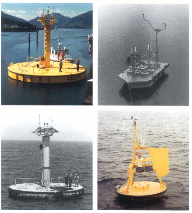
Figure 15
Pictures of representative moored buoy types deployed in the Alaska/Bering Sea (12-meter discus), mid-Gulf of Mexico (10-meter discus), Hawaii (6-meter NOMAD), and Great Lakes (3-meter discus) regions.
(Source: U.S. Department of Commerce, National Oceanic and Atmospheric Administration)
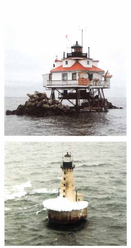
Figure 16
Pictures of representative C-MAN stations at Thomas Point, Maryland, and Stannard Rock, Michigan. (Source: U.S. Department of Commerce, National Oceanic and Atmospheric Administration)
in the gaps between the main islands. Forecasters know that the easterly trade winds tend to be channeled and accelerated in the gaps between the islands. What they lack are specific measurements on which to base the timing (onset and duration) of high wind and dangerous surf advisories and warnings.
As noted in Chapter 3, the Gulf of Mexico is occasionally ravaged by dangerous tropical storms that enter the region from the Caribbean. Furthermore, the southwestern Gulf of Mexico (Bay of Campeche area) is a favorable region for the genesis of tropical storms, especially early and late in the hurricane season. The proposed moored buoy additions in the Gulf of Mexico are designed to allow forecasters at TPC to monitor the details of tropical storm development and movement in anticipation of refining tropical storm watches and warnings; this helps fulfill the international responsibilities of TPC. For similar reasons, a moored buoy has been proposed to be situated in the western Caribbean equatorward of Jamaica. Hurricanes that track through this region frequently reach the Gulf of Mexico and have been some of the most intense storms on record in the Atlantic basin. Another critical need area lies near Puerto Rico, the U.S. Virgin Islands, and the Mona and Anegada Passages. Farther east, it is proposed that additional drifting buoys be deployed as needed between 10–20°N and 35–55°E to help TPC forecasters in preparing 5-day outlooks and monitoring environmental pressure, wind, and SST conditions in a region critical to the passage of African disturbances that often grow into tropical depressions and TCs. Note that the data provided from the proposed moored and drifting buoy additions will also be used by NCEP to initialize their operational global weather and climate prediction models.
The future buoy network should be redesigned with specific warning and forecast objectives paramount. Based on previous uses of the buoy network for hurricane forecast needs, a mix of moored and drifting platforms would be optimal. For example, an offshore “Maginot” first line of defense is required to provide real-time surface truth for aircraft reconnaissance observations while potentially dangerous storms are still offshore, and to provide input for final landfall surface wind distribution forecasts. In addition, a second line of buoys is required in the coastal zone for the purpose of immediate warnings, forecast verification, and post-storm critical wind analysis for comparison with storm surge damage and coastal wind damage. Although the network of coastal C-MAN sites assists in this effort, it is not possible for these sites to be totally representative of offshore exposures.
Central to implementing this concept is a totally new redesign effort currently underway at NDBC. The concept is to design a new, low-
cost plug-and-play platform in which sensor suites would be modular and the latest in communications, computer, and sensor technology would be employed to reduce costs significantly. Future platforms would be smaller than previous ones, only 3 m in diameter with a 3 m mast for winds. The 10 m platform design currently in use was driven by wave requirements and the need for a stable observing platform. However, new methods for directional wave spectra have been developed from industry and university research laboratories that can be deployed for smaller platforms. In addition, matching the instrument capability with the observation requirement should reduce costs while increasing efficiency. Pressure sensors, for example, are an order of magnitude cheaper for forecast requirements of, for example, ± 1–2 hPa rather than ± 0.1 hPa. Reliable new and critically needed sensors for humidity/dew point have been developed in industry and university laboratories and can now be deployed. The lack of a moisture sensor has been a critical deficiency in the existing network for the past 20 years. Likewise, new optical technology for rain measurement can now be deployed on buoys as demonstrated in the Tropical Ocean-Global Atmosphere Coupled Atmosphere-Ocean Experiment (TOGA/COARE) and new acoustic technology for wind speed and direction is now maturing and can be used in conjunction with in situ conventional and sonic anemometers for wind speed. The new modular design concept can produce a buoy platform for 25 percent of the cost of previous platforms, thus allowing for the deployment of additional platforms at current funding levels.
In concert with the moored buoy array, selective air-deployments of drifting buoys should be planned and conducted to obtain critical surface observations ahead of and within specific storm systems, especially hurricanes. For this task, a reserve stockpile of new, low-cost drifters should be assembled prior to each hurricane season ready for use in critical landfall forecast situations. Four buoys per deployment could reduce data-void regions between existing moored observational platforms. The technology for doing this has been successfully demonstrated during the 1995–96 hurricane season. A second drifter array should also be deployed over the central and eastern Atlantic for monitoring African wave disturbances that often breed tropical storms. Such an array concept was successfully demonstrated during the 1996–97 hurricane season. It was shown that significant observations concerning storm development could be obtained without having to deploy aircraft reconnaissance assets at an early time period when potentially dangerous storms are far from landfall. Also, this drifter array provided valuable SST observations that showed water temperatures of 0.5–2.0°C warmer than values estimated remotely from satellite retrievals
over the Atlantic. The SST discrepancy arose because the presence of widespread Saharan dust layers over the Atlantic produced a thick aerosol layer in the lower to middle troposphere that artificially lowered satellite-sensed SSTs. The dust-influenced satellite cool SST bias led to the conclusion that storm development potential was lower than was really the case and is another example of why surface-based observations are necessary to complement remotely sensed observations.
Review of Complementary Observing Systems
Presently no comprehensive plan exists within NOAA for integrating disparate observational systems that are crucial to weather forecasting and climate monitoring. For its data to be most effective in forecasting and research, the core base-funded buoy/C-MAN network needs to be integrated with other land-based and remote sensing observational platforms into a comprehensive global observation system that can generate data sets that can be used to construct global, regional, and local analyses. One example: Integrate the Next Generation Water Level Monitoring System with the buoy/C-MAN system. These analyses will be used to initialize atmospheric and oceanic prediction models for multiple purposes, such as: (1) preparing routine weather forecasts, (2) anticipating where warnings for hazardous weather are likely to be needed several days in advance, (3) making forecasts of intraseasonal and interannual climate variability, (4) issuing wind, wave, swell, and current forecasts to facilitate toxic spill cleanups, and (5) conducting scientific research.
The need for an integrated data approach for weather and climate data was recently articulated by Thomas R. Karl, chair, Climate Research Committee, in a letter dated October 17, 1997 to the Honorable Timothy E. Wirth, Undersecretary for Global Affairs (Appendix B). The existence of a comprehensive data acquisition and management plan, supported by a commitment to base funding of the critical components, is essential if the United States is to meet its international commitments in the weather and climate arena and provide its citizens more timely and accurate warnings of hazardous weather, particularly in the increasingly populated coastal regions, within the context of the modernized and restructured NWS. Undersecretary Wirth then presented these collective ideas that embraced the above position, as the principal speaker in a special session entitled “Mitigating Against the Effects of Natural Disasters” (of which 80 percent are weather related) at the November 17, 1997, meeting of the National Association of State Universities and Land Grant Colleges in Washington, D.C.
Recommendation #2:
A comprehensive review of all complementary observing systems that are essential for providing crucial global weather and climate data for operational and research purposes, including the buoy/C-MAN systems, should be conducted, and this review should lead into a study of how to design and implement a coupled atmospheric and oceanic observing system for weather and climatic prediction using surface and space-based platforms.
Given that research and operations are inextricably linked, this assessment should be done within the context of the ongoing NAOS evaluation by NOAA, and with the recognition of the programmatic goals of the USWRP and U.S. Global Change Research Program.
A Proposed Buoy/C-MAN Deployment Strategy
Much of this study looks at the needs and capabilities of a national buoy/C-MAN network from a technical perspective. The two technical recommendations of this report must be considered and the following aspects incorporated when deciding how, where, and at what pace to implement the required system and in any buoy/C-MAN deployment, repair, replacement, and abandonment decisions (note the letters from the U.S. Coast Guard and Boat/USA in Appendixes C and D).
A comprehensive and rigorous quantitative analysis demonstrating the benefits of maintaining a coastal observing system is needed. The analysis will help identify priorities for platform and instrument installation, increase community use of data and forecasts, increase public awareness of the infrastructure needed to provide weather warnings and forecasts, and strengthen overall community support for the program. This analysis is part of a recommended strategy for modifying the existing MAROB plan.
First, it will be necessary to examine which coastal areas are climatologically most prone to storms and to assess the magnitude of the danger from these storms. In addition, more study will be required to determine where observations may yield key clues as to development and movement of storms that will have greater impact further inland, as in the monsoon rains of the southwest or winter snows in the Rocky Mountains and Great Plains.
Second, as part of the climatological assessment, it must be determined which coastal regions are also prone to local weather changes. These changes may involve, for example, nearby upwelling regions that may increase fog or coastal topography that may alter winds. These create hazardous condi-
tions, often sudden and unpredictable, that can be detected by a well-positioned sentinel buoy.
Third, the number of people at risk will vary in proportion to the population density. A further breakdown in the assessment of those at risk would consider populations without the means to protect themselves or retreat from advancing storms and the need to protect particularly vulnerable or valuable investments, say for reasons of national and economic security or public safety. The coastal population density and the magnitude of the seasonally varying coastal storm threat must be considered in any buoy/C-MAN deployment, repair, replacement, and abandonment decisions.
Fourth, the scale of storms that impact our coasts suggests that to be fairly certain of determining the intensity and other important characteristics of the storm, points of observation should be appropriately spaced 30 to 50 km apart in the alongshore direction. While this may seem extreme and too expensive to contemplate, this nonetheless should be considered, particularly when matched against the aforementioned criteria and the importance of mesoscale nowcasting and forecasting to the NWS.
Fifth, as citizens begin to understand that they can access data derived directly from the buoy/C-MAN sites in near real-time via the Internet, the number of users will continue to grow. Evidence to support this assertion has been demonstrated in Figure 14. This knowledge will increase awareness of hazardous environmental conditions and reduce the risk of mishap. Thus, in areas where fishermen and recreational users of the coastal zone are particularly active, they should be encouraged to access and use this information resource for their safety.


