
Chapter One
Introduction
The network of coastal marine (C-MAN) and offshore moored buoys provides a critical source of continuous meteorological and oceanographic data. Platforms and the suite of instruments they hold vary according to need. Typically wind, air and water temperature, air pressure, and waves are measured. In addition to support from the NWS, funding for the network is provided from several sources, including the Department of Interior (Western Pacific and Mineral Management Service), NASA, National Ocean Service, St. Lawrence Seaway Development Corporation, U.S. Coast Guard, U.S. Army Corps of Engineers, and the U.S. Navy. Real-time observations from these buoys are used by public and private weather forecasters to provide information on possible hazardous wind, sea-state, and water-level conditions to public safety officials, public and private marine interests, shipping companies, fishing and recreational interests, and the general public. For example, fishing interests make use of sea-surface temperature (SST) and wind and wave observations from these buoys for protection, safety, and to reduce the costs of recreational and commercial fishing expeditions. Real-time buoy observations are used frequently in search and rescue missions by the Coast Guard and by various agencies responsible for ameliorating the effects of marine accidents, such as toxic oil spills, which can threaten local and regional ecosystems. And research leading to improved forecasts and greater understanding of ocean/atmosphere effects on coastal currents and ecosystem structure, for example, often depend on the long time series of observations from these platforms.
The meteorological and oceanographic observations collected from the C-MAN and moored buoys also are used by scientists in a variety of basic and applied research (discussed more fully in Chapter 4). For example, wind, wave, SST, mean sea-level pressure, and air temperature observations can be used in case studies of important local and regional weather phenomena (Figure 1). Similarly, the buoy/C-MAN observations can be stratified on weekly, monthly, seasonal, annual, and interannual time scales to help document important local and regional climate features, including their
intraseasonal and interannual variability. These analyses can be effective in isolating important climate signals associated with the El Niño-Southern Oscillation (ENSO) or other persistent flow anomalies and teleconnections, such as the North Atlantic Oscillation (NAO) and the Pacific-North American pattern.
It is important to appreciate the critical link that exists between operational and research communities, and how this linkage assures that buoy/C-MAN observations are used to the fullest extent. In support of their marine warning and public safety responsibilities, weather forecasters are constantly monitoring the meteorological and oceanographic observations routinely transmitted from the buoys/C-MANs. As part of this regular monitoring process the forecasters gain a keen sense of understanding of the operational problems associated with coastal and marine meteorology. They also gain understanding of scientific issues and challenges that they face in their efforts to produce better forecast models. Knowledge of operational constraints in forecast procedures can be communicated to researchers at workshops and conferences or through individual local contacts. This communication can lead to more rapid and effective transfer of technology from
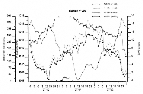
Figure 1
Time series of hourly meteorological observations at buoy 41001 (near Cape Hatteras, North Carolina, at 34.68 N and 72.64 W) for the period 0000 UTC 8–12 July 1996. This period corresponds to the time Hurricane Bertha passed to the south of the moored buoy location. Observations reported for sea-level pressure (hPa), wind direction (degrees), wind speed (m/s), and peak gusts (m/s).
(Source: National Data Buoy Center Station Information Internet Site)
research to operations and to improved services. A few forecasters at individual NWS offices are also working with university scientists on operationally oriented research of local and regional interest (e.g., marine air surges along the west coast of the United States) through the Cooperative Meteorological Education and Training program sponsored by the NWS and the University Corporation for Atmospheric Research.
At the National Centers for Environmental Prediction (NCEP), the increasing use of coupled atmospheric and oceanic models in support of research and operational climate prediction on seasonal to interannual time scales requires the continuous monitoring of oceanic conditions (and the atmospheric conditions above the ocean) on a global basis. The buoy/C-MAN observations, as well as observations obtained from a growing use of drifting buoys, are crucial to the overall success of the NCEP mission. Likewise, this ocean-based monitoring capability is crucial if scientists are to observe and document trends in SST, sea-level pressure, wind, and temperature regimes. The quality of these analyses will determine how well we understand the relationships between the variability of these quantities and that of large-scale intraseasonal and interannual climate.
Persistent and highly anomalous weather regimes are frequently associated with extended periods of temperature or precipitation extremes that impose enormous stress on humankind. Both the research and operational communities have vested interests in learning more about the causes of weather and climate variability. They understand that complex weather and climate issues must be addressed from a global perspective, and that knowledge gained will lead to improvements in public safety. Both communities have grown to depend routinely on the regular and timely collection of meteorological and oceanographic observations from an array of marine locations. In this context, research and operations are inextricably linked. And this linkage can only grow stronger thanks to ongoing activities at universities, in private industry, at various NWS offices, and at federal research laboratories and entities such as NCEP.
This study originates from a request by the Undersecretary of Commerce for Oceans and Atmosphere to recommend a distribution of observing platforms that would maintain essential weather forecast capabilities. Prompting this request was a shortfall in funding that makes it improbable that 33 of the 118 buoy/C-MAN stations can continue under NOAA operations. In further discussion with the undersecretary and NOAA's chief scientist and staff, it was recognized that identification of specific platform placements would have to be done taking factors into account that were beyond the scope of this study, such as identification of populations most at risk to coastal weather and related hazards. The study nonetheless identifies
such factors and defines a strategy, based on scientific principles, for ultimately determining these platform locations. Both appear in Chapter 5 along with a possible distribution of buoy/C-MAN stations. One point is worth highlighting. The first question likely to be asked when beginning a study of this nature is, “What do numerical experiments tell us about the impact on the weather forecast of removing a number of surface observations?” In the course of this study, no successful assessment of specific components of a surface observational network could be found. There appears to be no firm evidence that can point to either a positive or a negative impact for a specific surface station on forecast accuracy. One recent study (Huo et al., 1998) shows that surface marine observations have a positive effect on numerical model initialized analyses and the resulting forecasts. There is hard evidence on the spatial scale of storms, which helps define the ideal spacing of observing sites. However, the recommendations of this report are somewhat judgemental, but are based on long years of experience by many professional weather forecasters, those who insure against property loss, and Coast Guard staff, who search for and rescue those whose lives may be in jeopardy offshore. The NWS, in ongoing studies related to the NAOS, is evaluating this issue with respect to the nation's radiosonde network. But quantitative, definitive results are not yet available. The need to reduce this ambiguity is among the major justifications for a review of all complementary observing systems (see Recommendation #2 in Chapter 5).
The Network Infrastructure
The National Data Buoy Center (NDBC) began operations in the late 1960s when buoy development and operation was conducted by the U.S. Coast Guard (USCG). NOAA took over the operation of NDBC in 1970, at which time the program was relocated to the Stennis Space Center in Mississippi. NDBC is staffed by NOAA, the Coast Guard, and contract employees. In fiscal year (FY) 1997 the NDBC budget was approximately $12 million. Additional funds were garnered from other federal and state agencies in support of non base-funded buoys and C-MANs. Given the remoteness and wide geographical locations of NDBC buoys, the timely deployment and maintenance of these stations require careful planning and execution to minimize critical data loss that must be balanced against very real constraints related to budgets, weather, and resource availability.
NDBC's fleet of moored buoys includes six types: 3-meter, 10-meter, and 12-meter discus hulls, 6-meter boat-shaped (NOMAD) hulls, and the newest, the Coastal Buoy, and the Coastal Oceanographic Line-of-Sight (COLOS) buoy (Figure 2). Hull types depend upon buoy location,
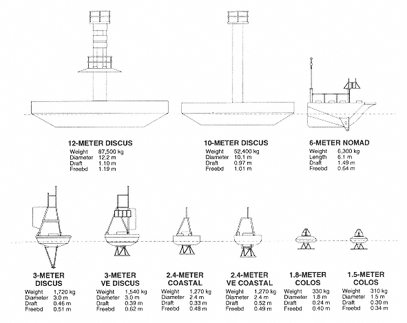
Figure 2
Schematic drawings of the six standard moored buoy hull types used by NOAA-NDBC including 3-meter, 10-meter, and 12-meter discus hulls, a 6-meter boat-shaped (NOMAD) hull, and the newer design 2.4-meter coastal buoy and 1.5-meter Coastal Oceanographic Line-of-Sight (COLUS) buoy. (Source: National Data Buoy Center)
sustainability, and intended measurement purposes. For example, moored deep-ocean buoys usually require large discus hulls and sophisticated anchoring systems.
Typically, buoy and C-MAN systems include observation of water temperature, wind and wave characteristics, and air pressure. Buoy platforms offer many opportunities to measure atmosphere and ocean characteristics, including, for example, sampling of atmospheric aerosols (Sholkovitz et al., 1998). Other sensors may prove useful on these platforms, including those capable of measuring solar radiation, fluxes of material across the air-sea interface, and upward looking sounders for inversion height, cloud droplets, and profiles of wind and temperature. Recent advances in sensor, buoy, and communications technologies will lead to lower costs and improve measurements capabilites. NDBC is evaluating acoustic anemometers that will be less prone to mechanical failure than the present propeller anenometers, and therefore reduce life-cycle costs. Nevertheless, these sensors will extend the upper limit of operational wind-speed measurements. Prototype directional wave measurement systems based on simpler sensors and advanced digital signal processing have the potential to greatly reduce sensor costs. New ionomer foam 3-meter buoys are being introduced to increase reserve buoyancy and reduce vulnerability to vandalism. Compared to existing metal hulls, repair and refurbishment costs of the foam hulls will be lower. Higher transmission rates through the Geostationary Observational Environment Satellite (GOES) system will lead to faster data dissemination and increase the amount of data transmitted. If additional capability is desired, low earth orbit satellites can be used, though at increased costs. Regardless of the satellite, the buoys will transmit event-driven “special” observations to alert forecasters of rapidly changing conditions; this will significantly benefit the NWS marine warning and advisory mission. Finally, mariners will be able to hear the latest observations over the telephone because of computer voice generation technology tied into the Internet.
Data obtained from moored buoys, subsequent to automated processing on site, are routinely transmitted to a NOAA GOES. From there the data are distributed widely to public and private user groups in addition to the NWS. Moored buoy data are further quality checked at NDBC and then sent to the National Climatic Data Center (NCDC) and the National Oceanographic Data Center (NODC) for archiving purposes where they are made available to the research and operational communities. C-MAN data are processed similarly by NDBC and made available through NCDC and NODC. Drifting buoy data collected by NDBC are transmitted to Polar Orbiting Environmental Satellites (POES) and then relayed to ground
stations. Data transmission from drifting buoys to POES and from POES to ground stations is restricted to when the satellites are within line of sight of the buoys.
NDBC estimates buoy costs in 10-buoy sets to take advantage of the economies of scale. NDBC cost estimates further assume a fully funded existing infrastructure. The numbers that follow represent a range of costs (FY98 dollars) with the lower numbers representative of nearshore or coastal stations and the higher numbers for deep-water moored buoys (in lots of 10):
- manufacture: $1,185,000 to $2,615,000
- deployment: $240,000 (the difference is not significant for the different buoy types)
- maintenance: $474,000 to $547,000 per year; and
- operation: $81,000 per year (the difference is not significant for different buoy types).


