
Page 9
2
Climate Attributes That Influence Society
Examining the ways people and their activities depend on or are controlled by climate reveals the climate variables that have the most influence on our lives and well-being. Our food production and agricultural systems depend highly on local temperature, precipitation, and the amount of sunlight during the growing season. Our forests, which provide wood for construction as well as habitat for our heritage of flora and fauna, depend similarly on particular temperature and precipitation regimes. Our water resources depend on precipitation and temperature (which controls evaporation and melting of ice and snow) and on the natural ecosystems and man-made features that affect water storage and control runoff. Extremes of precipitation (or other processes in the hydrologic system) can lead to drought or floods, often accompanied by fire or severe erosion, which endanger natural habitats, communities, and resources. Our coastal regions are especially sensitive to changes in sea level; long-term changes may involve only a slow rise in sea level, but water levels can be raised rapidly by storm surges, inundating coastal communities and wetlands. Our health depends directly on temperature and humidity (both of which contribute to heat stress) and on ultraviolet radiation (which contributes to skin cancer); indirectly, human health is affected by temperature, precipitation, land cover, and land use, which together contribute to determining the pathways for disease-bearing vectors. Ecosystems on land and in the oceans provide habitat for the biological diversity of flora and fauna that supply us with food, medicine, recreation, and other resources; all are dependent on a wide array of climatic variables. Finally, climate is a fundamental driver of our economic activities, contributing to the demands for energy, the maintenance of our food and fiber resources, the safety of our transportation systems, the appeal and lifestyles of different regions, the maintenance of our natural biological resources, the availability of outdoor recreation, and much more.
These complex and extensive interconnections point to the six attributes influencing the Earth's climate system that appear to be of most importance to society. These are:
• precipitation and water availability;
• temperature;
• solar radiation;
• storms;
• sea level; and
• ecosystems.
The value of their mean state or condition, how they vary over time (on scales of days, seasons, years, decades, and centuries), their character and extent geographically, and the frequency and persistence of extreme values all determine the availability of resources on which we depend, while influencing our ability to lead healthy, productive lives. Certainly other attributes are important to our environment and well-being, such as winds (which we treat below, under "Storms"), air quality, and even atmospheric composition in general. However, with regard to developing a science strategy for understanding future climate change and variability, these six attributes are of particular importance. They have been demonstrated to undergo significant variability over decade-to-century time scales in the past and are therefore likely to do so in the future, and they are intimately entwined within the climate system that is the focus of this science plan. Atmospheric composition also satisfies these criteria, but it is so essential to the Earth's radiative balance and atmospheric dynamics that we have opted to include it in our discussions of fundamental climate-system components in Chapter 5.
The research strategy outlined in this report focuses on the scientific issues that must be addressed to best advance our understanding of how these six attributes can be expected to change in the future. Being able to predict changes in their properties, and to recognize the conditions that indicate when significant changes are actually underway, will enable
Page 10
society to optimize its activities and prepare for the changes in the most cost-effective way possible. These capabilities will enhance our environmental security and sustain our continued economic success.
This chapter expands on some of the important, most societally relevant influences exerted by these attributes, documents our knowledge of how they have changed in the past, and explains why we have chosen to focus on them now.
Precipitation and Water Availability
Freshwater is the very basis of terrestrial life, and is arguably its most precious natural resource. Water influences nearly every aspect of society and day-to-day life. From the huge amounts of freshwater required for modem industrial and agricultural production to the bucket of clean water so highly prized in less developed countries, the uninterrupted supply of clean freshwater is necessary for the overall health and continuance of our societies and economies. In addition, freshwater distribution influences energy production and utilization, water quality, fisheries and land ecosystems, forestry, insurance, recreation, and transportation. The longevity of aquifers, the reliable flow of rivers, and the fall of rain determine where civilizations can grow and prosper. Significant investments in our infrastructure, such as the construction of dams and levees, and water-resource planning and management in general, are based on our current understanding of the supply, storage, and dispersal of freshwater. Any changes or disruptions in the freshwater cycle as we have come to know and rely on it can thus have widespread consequences, with implications for all levels of society and every individual in it.
Variations in the water supply will have more serious effects on some societies than on others. Less developed countries, particularly those with semi-add climates, marginal agriculture, and rigid social structures, are clearly vulnerable to growing-season failures: The history of northeastern Brazil is replete with examples of major failures of growing-season rainfall (see Figure 2-1) that caused mass migrations of Nordestinos to other parts of Brazil (Magalhaes and Magee, 1994). More developed societies, through their economic prowess, are less vulnerable to the year-to-year variations of precipitation. For example, the record rainfalls over the midsection of the United States in June to August of 1993 led to record flooding (Kunkel et al., 1994; Bell and Janowiak, 1995); the Mississippi River was above flood stage for almost three months at St. Louis. This resulted in extraordinary damage (estimated at $15-20 billion—see Changnon, 1996), yet the flood, while causing considerable local hardship, produced only a blip in the U.S. economy. Similarly, the record summer drought of 1988 caused an estimated $30 billion in agricultural damage alone (Trenberth and Branstator, 1992), but the strength of the U.S. economy (if not the balance sheets of the people in the region) was easily able to withstand this climatic event.
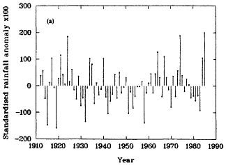
Figure 2-1
Northeast Brazil rainy-season (Feb-May) standardized precipitation anomalies.
(From Ward and Folland, 1991; reprinted with permission of John Wiley and Sons, Ltd.)
As the time scale of precipitation variability increases, even the most developed countries become vulnerable. The United States enjoys an enviable agricultural sector that has become more efficient over the years, employing an ever-decreasing share of the population in the task of feeding its, and the world' s, people, and showing great resilience in recovering from the random flood or drought, no matter how severe. But during the 1930s, when the economy was particularly fragile, an entire decade of low rainfall caused migrations and dislocations in the United States similar to those of northeastern Brazil. Indeed, recent paleoclimatic evidence from enclosed lakes (Laird et al., 1996) suggests that such droughts were considerably more severe and longer-lived in the past, relative to what we have experienced in the past few hundred years (Figure 2-2). Other parts of the paleoclimate record also suggest that such severe droughts are not unprecedented. Even today, when the economy of the United States is far more stable than during the Depression years, a decade of poor rainfall in the fertile agricultural regions would lead to economic dislocations and would place grave strains on the national and global economy. More frequent occurrence of floods like those in the Midwest in 1993 and 1997 would have similar types of effects.
The patterns of rainfall in the Sahel region of Africa also show decadal- and centennial-scale variability (Figure 2-3). The devastating impact of prolonged low rainfall on the mostly nomadic societies of sub-Saharan Africa has required massive and continuing infusions of world resources to avoid even greater disasters (Glantz, 1994). Such long periods of drought leave little room for adaptation by vulnerable populations, or for future economic development, and they affect the intellectual development of children in ways that will echo through generations.
An even longer drought may well have spelled the doom of the Classic Maya civilization (Hodell et al., 1995). The
Page 11
period AD 800-1000 was unusually dry, and corresponded with the decline of the Classic Maya. It is not difficult to imagine that a society well adapted to a given level of precipitation would find it difficult to adapt to a long period of drought, in this case one lasting 200 years.
The longest precipitation record comes from the Greenland ice cores (see, e.g., Grootes, 1995), which provide information on snow accumulation on the Greenland ice sheet for the last 100,000 years and more. Annual snow layers are discernible for the more recent millennia; Figure 2-4 shows snow accumulation during an 8,000-year period during which Greenland suddenly emerged from glacial conditions at about 15,000 BP, fell back into glacial conditions during the Younger Dryas period, and finally emerged into our cur-
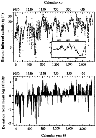
Figure 2-2
Reconstruction of the salinity of Moon Lake in the Northern Great Plains
of the United States for the last 2,300 years. Upper panel: Logarithms
of diatom-inferred salinity; smooth curve is filtered data. Bottom panel:
Log deviation from 2300-year mean. Greater salinity implies greater
desiccation in both curves. Note that the 1930s drought (see inset) is
relatively minor relative to the more severe and long-lived droughts
of the preceding millennium. (From Laird et al., 1996; reprinted with
permission of Macmillan Magazines, Ltd.)
rent interglacial state. Superimposed on these upheavals was a background of precipitation variability on time scales ranging from interannual to centennial. We may safely assume that dec-cen variability in precipitation has always been with us, and thus can be expected in our future as well.
Temperature
Temperature probably influences our day-to-day comfort level more than any other environmental factor. Society is especially vulnerable to long-term changes in temperature because of the importance of temperature conditions to crop growth, heat stress, energy usage, and recreation. Also, the deleterious impacts of decade-to-century-long anomalies in temperature may be compounded by anomalous hydrologic conditions, with direct effects on agriculture, water supply, ecosystem stability, and so on. Agricultural vulnerability is higher in the less developed countries, where there are few safeguards to limit the consequences of temperature changes. However, as with freshwater, even highly developed countries are vulnerable to temperature changes as the duration of anomalies and magnitude of variability increase. Such changes may increase with a changing mean climate as noted by Karl et al. (1996), because even small shifts in the climatic mean may lead to significant increases in the number of extreme temperature events, such as the heat waves that sporadically strike during summer months in the midwestern and eastern United States, or the number of frost days. These directly influence agriculture through a variety of means.
Temperature changes are also directly related to changes in energy consumption for heating and cooling (Figure 2-5), which can have immediate impacts on consumer supplies and energy costs. From a broader perspective, because the global temperature distribution is the engine driving the Earth' s climate system, temperature controls the primary circulation patterns, which in turn influence the precipitation and evaporation patterns, the tracks and intensities of storms, and other large-scale climate patterns as well. Consequently, while the direct impact of temperature change on society is considerable, its indirect impacts, through its influence on the other important climate attributes, are enormous.
There is considerable evidence documenting modern change in temperature over decades and centuries. Of particular relevance are those variations in the period leading up to the recent warming trends observed in instrumental records, because they give a clear indication of the nature and magnitude of the climate system's natural variability. Variations during the last 150 years or so of the modem instrumental records may reflect both natural and anthropogenic change. Over this last 150 years, temperatures have increased in most parts of the globe. However, this increase has not been uniform geographically and has not been steady over time (Figure 2-6). In the Southern Hemisphere, temperatures have increased more or less monotonically since the turn of the century, whereas in the Northern Hemisphere,
Page 12
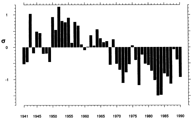
Figure 2-3
Sahel rainfall as a function of time. Time series of yearly average normalized April-to-October departures for 20 sub-Saharan stations
located between 11º and 18º W of 10º E. (From Ropelewski et al., 1993; reprinted with permission of the American Meteorological Society.)
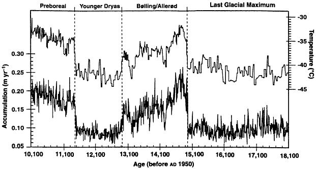
Figure 2-4
Snow accumulation in Greenland as a function of time from GISP 2 ice cores (bottom trace) vs. d
18O converted to temperature
(top trace). (From Kapsner et al., 1995; reprinted with permission of Macmillan Magazines, Ltd.)
Page 13
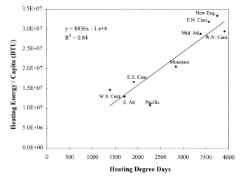
Figure 2-5
Relationship between temperature (heating degree days) and the energy
consumption for residential heating by U.S. census regions. More energy
is generally consumed for home heating in the colder regions of the United
States. Pacific includes WA, OR, CA, AK, and HI; Mountain: ID, MT, WY,
NV, UT, CO, AZ, and NM; W.N. Cent.: ND, MN, SD, IA, NE, MO, and KS;
E.N. Cent.: WI, MI, IL, IN, and OH; W.S. Cent.: OK, AR, TX, and LA; E.S.
Cent.: KY, TN, MS, and AL; New Engl.: ME, NH, VT, MA, CT, and RI; Mid.
Atl.: NY, PA, and NJ; S. Atl.: WV, MD, DE, VA, NC, SC, GA, and FL. Residential
heating data from 1993 EIA Residential Energy Consumption Survey (EIA, 1995).
(Figure courtesy of P. Schultz, National Research Council.)
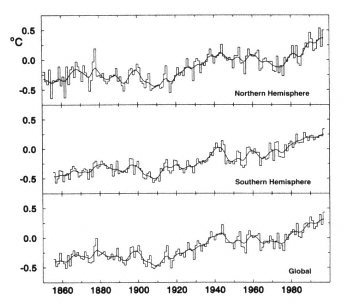
Figure 2-6
Combined land-surface and sea surface temperature (ºC) from 1861 to 1994,
expressed as anomalies from the 1961-1990 average. (From IPCC, 1996a;
reprinted with permission of the Intergovernmental Panel on Climate Change.)
temperatures have risen more episodically, with the bulk of the warming concentrated in the periods about 1920-1930 and about 1975-1995. Globally, the net increase over the last century amounts to about 0.5º C in mean annual temperature (Ghil and Vautard, 1991; Jones and Briffa, 1992).
In the United States, the overall pattern of temperature change (Figure 2-7) has been similar to the global pattern, but geographically there are strong regional differences (Dettinger et al., 1995; Karl et al., 1996). Over the last 100 years there has been a strong increase in temperature over most of the northern and western sections of the country, but in the southeast and south central regions, temperatures have declined (Figure 2-8). Such variations reflect regional circulation anomalies that are otherwise obscured by large-scale averaging.
The period of warming in the twentieth century followed
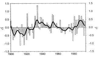
Figure 2-7
Departures from the long-term mean of area-aver-aged annual temperature
over the contiguous United States (1900-1994). The dark line is a nine-
point binomial filter. (From Karl et al., 1996; reprinted with permission of the
American Meteorological Society.)
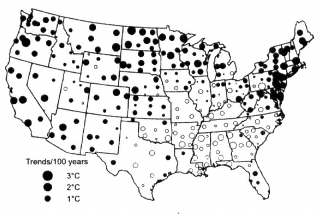
Figure 2-8
Trends in mean annual temperature (1900-1994) expressed as ºC per hundred years.
Closed circles represent warming, open circles cooling. (From Karl et al., 1996;
reprinted with permission of the American Meteorological Society.)
Page 14
a time of lower temperatures globally, which is often referred to as the ''Little Ice Age'' (Jones and Bradley, 1992). Some authors argue that this period began in the fourteenth century; others find stronger evidence for a significant mid-sixteenth-century decline in temperature (Bradley and Jones, 1992). Like modem warming, Little Ice Age cooling showed geographic variability; although the period is not well documented, in mid- and higher-latitude regions it seems to have been characterized by episodes of temperatures generally cooler than the present, lasting as long as a century, interrupted by only slightly warmer periods. The generally cooler conditions had profound environmental consequences in many parts of the world; glaciers advanced in mountain regions and in Europe, and the much colder winters froze rivers and canals, frequently bringing the transportation systems of the day to a halt. Snowfall was higher and snow stayed on the ground for longer periods in many regions (Lamb, 1972).
Historians have argued that the Little Ice Age coincided with a time when the balance between food supply and a greatly expanded European population was precarious, making European society highly vulnerable to crop failures. The more frequent presence of cold air caused unexpected freezes and heavy rains, devastating agriculture and leading to crop failures. As a result, large numbers of people died from malnutrition or starvation. Many countries are still vulnerable to anomalous climatic conditions, especially where agricultural production barely balances the needs of a growing population.
Glacial deposits in the mountainous western United States and Canada, tree-line and tree-ring studies, and anecdotal historical evidence indicate that many parts of North America also experienced Little Ice Age conditions similar to those of western Europe. Indeed, the well-known abandonment of Norse settlements in Greenland is thought to have been at least partly a consequence of colder climatic conditions and a shorter growing season than the original settlers had experienced in the preceding milder episode, often referred to as the "Medieval Warm Epoch." Whether this warmer episode was of more than regional significance remains unknown (Hughes and Diaz, 1994).
For the Northern Hemisphere as a whole, the intervals of lowest temperature in the last 600 years were in the late fifteenth, late sixteenth, and entire nineteenth centuries (Figure 2-9), although individual records show deviations from this large-scale average. Warmer conditions were more common
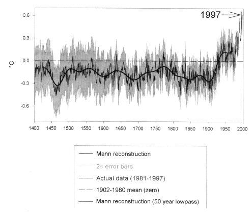
Figure 2-9
Reconstruction of mean annual temperature for the Northern Hemisphere (heavy lines),
based on a network of paleoclimate data calibrated against instrumental data in the twentieth
century. The lighter lines form an envelope describing the estimated uncertainty of individual
yearly temperature estimates (at the 95 percent confidence level). The low-frequency solid
curve is a 50-year low-pass-filtered version of the individual yearly values. (After Mann et al.,
1998; reprinted with permission of Macmillan Magazines, Ltd.)
Page 15
in the early sixteenth century and in most of the eighteenth century, although for the hemisphere as a whole, conditions comparable to the decades from 1920 onward had not been experienced for at least the previous several hundred years (Bradley and Jones 1993; Mann et al., 1998). The unusual nature of temperature conditions during the twentieth century, especially over the last 20 years or so, deserves emphasis; indeed, several years in the 1990s were warmer than any other time in at least 600 years (Mann et al., 1998). Recent low-latitude ice-core studies show in dramatic fashion that in those areas temperatures in the last decade were higher than they had been for at least 1,500 years in those areas (Thompson et al., 1993b). The loss of permanent ice caps and glaciers in the tropical Andes is of great significance for agriculture and the water-supply networks of Ecuador, Peru, Bolivia, and Chile. It has a negative impact on hydroelectric power production in those countries as well. Priceless paleoclimatic records are also melting away, often before they can be collected and analyzed.
It is important to recognize that the globally extensive instrumental recording of climate data, which forms the basis for our limited view of "global warming" began during one of the coldest periods of the last few centuries (Figure 2-9). More extensive long-term records of global temperature changes would allow a more rigorous statistical assessment of the current warming. It is clear that decadal-scale (and lower-frequency) temperature variations were also evident for many centuries prior to the nineteenth century, while greenhouse gases exhibited relatively little change. The fact that such temperature variations must have been unrelated to global-scale anthropogenic effects focuses our attention on the need to understand what drives such "natural" variability. Better records of past climate variations and of potentially important forcing factors, such as solar-irradiance changes or explosive volcanic eruptions, are needed. In particular, it would be especially valuable to examine the enigmatic Medieval Warm Epoch—a time often cited as having been warmer than the twentieth century, but so far not shown to have been warmer over an entire hemisphere, much less over the entire world (Hughes and Diaz, 1994).
Solar Radiation
Sunlight is one of the bases of life on this planet. It provides the energy needed to warm the Earth and evaporate water; its geographical distribution drives the Earth's climate system. Its vertical absorption and reflection play a major role in stratifying the atmosphere, affecting atmospheric circulation, winds, clouds, and a multitude of energy-balance feedbacks. Sunlight is an essential ingredient in the creation of the protective ozone layer, and is a direct source of natural, readily harnessed energy. It provides the light animals need to see and plants need for photosynthesis. It is basic to the food chain of most life.
The link between solar variation and climate or weather has been known for millennia; in the fourth century BC, Theophrastus correlated sunspots with rainy weather. Recent measurements of solar output have shown decadal-scale variations of less than 1 percent (Lean et al., 1992; Hoyt and Schatten, 1993; Zhang et al., 1994), but we know that it has been orders of magnitude greater in past eons, and presumably could be again. Variations in solar-cycle length and Northern Hemisphere climate anomalies parallel each other over the last 100 years (Friis-Christensen and Lassen, 1991; Labitzke and van Loon, 1993), and solar activity and sea surface temperature track each other well over the past 130 years (Reid, 1991; White et al., 1997b).
Solar ultraviolet radiation affects society through its role in health. It promotes the production of vitamin D, yet it is implicated in human skin cancer, suppression of the skin's immune system, and damage to plants (see, e.g., Coohill, 1991, and Krupa and Jager, 1996). The sun provides ultraviolet radiation in the wavelength region 280-320 nm (called UV-B) that is damaging to most plants and animals. For example, there is accumulating evidence of damage to Antarctic ecosystems (Smith et al., 1992) in the aftermath of the opening of the Antarctic ozone hole. Solar UV-B radiation' s impact on ecosystems in turn affects the natural cycles of water, carbon, and other nutrients.
The stratospheric ozone layer that shields the Earth by absorbing most of the UV-B radiation has changed. We do not have reliable decadal records of UV-B received at the Earth's surface and how it has varied through time. However, as Figure 2-10 shows, we do have clear observational evidence demonstrating that lower ozone columns result in higher UV-B irradiation, as predicted by models (WMO, 1995). Thus it has been possible to derive accurate calculated levels of surface UV-B irradiance, and hence of human exposure, under clear-sky conditions (Figure 2-11); note that an increase is evident throughout the middle latitudes.
The sun is also the source of photosynthetically active radiation (PAR), which is in the wavelength region 0.4-0.7 µm. The amount of PAR received at the Earth's surface is controlled by cloud cover—not only by the cloud droplet concentration and cloud thickness, but also by the spatial and temporal distribution of clouds, which varies considerably (see Figure 2-12). When the amount of cloud cover over a region changes for a long period of time, and the amount of PAR shifts, the growth of ecosystems may be altered. Such changes are thus important for agriculture and for natural or managed systems, such as forests. Since the middle of this century such long-term changes in cloud cover have in fact been observed (Figure 2-12). In addition to trends of increasing cloud cover in some regions, concomitant changes in other variables have also been detected, such as the change in cloud amount that accompanied a step-like increase in evaporation over the former Soviet Union around 1976. All such records are subject to systematic shifts as observers and instruments change; without knowledge of
Page 16
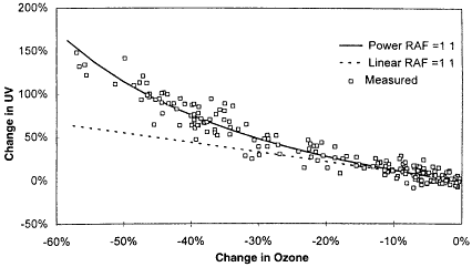
Figure 2-10
UV-B radiation reaching the Earth's surface as a function of ozone column, from both
measurements and models. (RAF is a radiation amplification factor.) Measurements
were made at the South Pole between February 1991 and December 1992. (From
Booth and Madronich, 1994; reprinted with permission of the American Geophysical Union.)
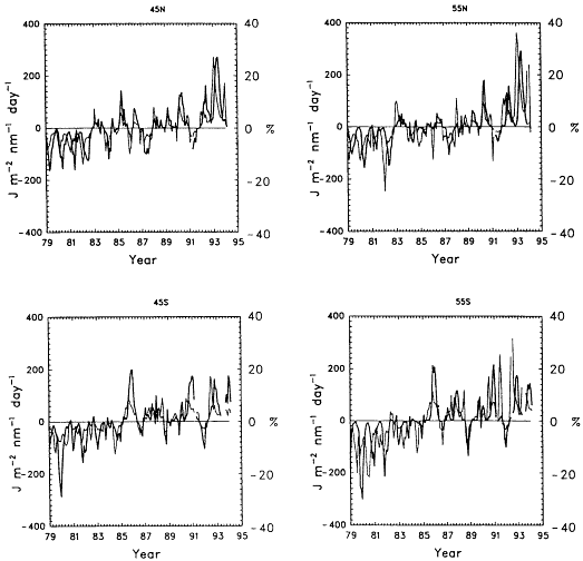
Figure 2-11
History of UV-B (310nm) at the Earth's surface for mid-latitudes over 15 years beginning 1979,
based on the ozone/UV-B relationship in Figure 2-10 and observed ozone-column data.
(From WMO, 1995; reprinted with permission of the World Meteorological Organization.)
Page 17
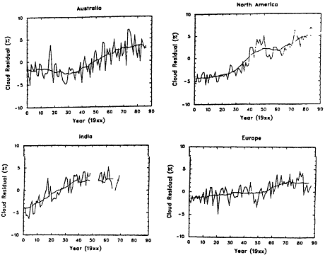
Figure 2-12
Cloud-cover changes over Australia, North America, India, and Europe since 1900, expressed as percent
deviations from the long-term mean. (From McGuffie and Henderson-Sellers, 1988; reprinted with permission
of the Canadian Meteorological and Oceanographic Society.)
these occurrences it is difficult to assemble a reliable dec-cen record of climate change.
The ability of solar radiation to influence the Earth' s temperature is controlled by several factors that have been shown to vary over decades and centuries. Among them are variations in the total solar output, changes in the amount of sunlight reflected from clouds and aerosols in the lower atmosphere, increases in aerosols in the atmosphere because of volcanic injections, and trapping of the Earth's thermal radiation by the greenhouse gases. These factors are discussed in greater detail in Chapter 5; we present here a single example of a direct impact on society caused by changes in total sunlight.
Like volcanic aerosols, tropospheric aerosols generated by industrial pollution can play an important role in the amount of radiation reaching the Earth's surface. In certain regions, such as the Sichuan Province of China, there are clear trends of decreasing visibility. Reduced visibility is often regarded as a quality-of-life issue, affecting principally our appreciation of our natural surroundings. However, in Sichuan the industrial haze is so severe that it has led to a substantial reduction in the annual mean solar energy reaching the surface over the past four decades. Records from the eastern United States indicate interdecadal changes in light extinction associated with sulfur emissions (Figure 2-13). These changes in visibility affected the solar flux at the ground, and thus likely also surface temperature.
Storms
Whereas the distributions of freshwater, temperature, and radiation affect us on a daily basis, the less frequent but more destructive side of nature is often realized in relatively short-lived episodes of severe weather associated with storms. Storms generally owe their destructive power to high winds, associated lightning, and high rates of precipitation in the form of rain, hail, sleet, and snow. In coastal regions, the high winds drive heavy waves and surges that cause flooding and beach erosion, often inflicting considerable, sometimes irreversible, damage on coastal communities and ecosystems. The entire landscape can be permanently altered. Storms are responsible for widespread personal-property destruction, deaths, and financial stress. The financial stress can be both personal (uninsured loss, increased premiums, higher taxes to cover government aid) and institutional (massive insurance payouts, federal and state disaster relief). Storms also influence recreation, power usage, and health. Thus, any change in their frequency of occurrence over dec-cen time scales can have considerable influence on economies (consider the substantial outlay of the U.S. insurance
Page 18
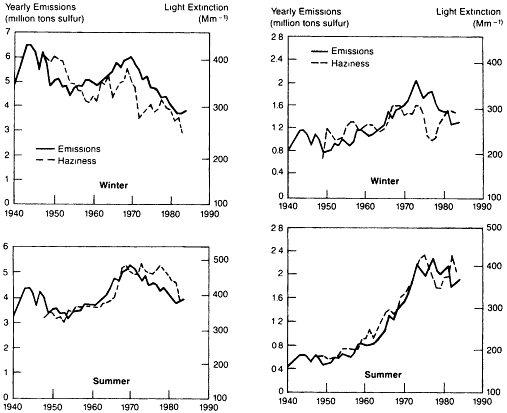
Figure 2-13
Comparison of historical trends for sulfur emissions and haziness for the
northeastern (left) and southeastern (right) United States (From NAPAP, 1991.)
industry in recent years related to major storms) and societies.
The word "storm" refers to an array of extreme weather phenomena that display a wide range of spatial scales and owe their existence to a variety of physical mechanisms (see, e.g., Palmen and Newton, 1969). Consequently, their impact is manifested through a variety of means and geographic extents. For example, in the mid-latitudes, wintertime extra-tropical cyclonic storms extend over hundreds to thousands of kilometers, although their severe weather is generally associated with smaller-scale features such as fronts and squall lines embedded in the large-scale disturbance (see, e.g., Wallace and Hobbs, 1977). In the subtropical and mid-latitude land areas, severe storms occur in all seasons (including summer) as a result of mesoscale (length scale of tens of kilometers) organization of convection. Forming relatively localized features, such as squall lines and the so-called multi- and super-cell storms, these storms are accompanied by strong wind gusts, tornadoes, lightning, hail, and flash floods. Tropical ocean regions spawn cyclones known as hurricanes and typhoons. These storms are somewhat smaller in size than mid-latitude cyclones, but their intensity tends to exceed that of the latter. Because they have a relatively large radius of influence where high winds combine with large amounts of precipitation, tropical storms are among the most dreaded natural phenomena. The largest destructive potential of these storms is in coastal regions, where population density is often high.
Several studies, focusing predominantly on the Atlantic where the historical records are longest, have indicated the existence of decadal-to-centennial fluctuations in storm intensity and distribution in the tropics and extra-tropics. Multidecadal changes in Atlantic hurricane activity were noted by Gray (1990) and Landsea et al. (1996). These changes consist of a higher-than-normal occurrence of intense hurricanes and hurricane days between the mid-1940s and the mid-1960s, and lower-than-normal occurrence between the mid-1960s and the early 1990s (Figure 2-14a,b). Despite the general decrease in the number of Atlantic hurricanes, the damage totals from these storms have increased dramatically since the 1940s (Figure 2-14c). The increasing damages are related to the greater vulnerability arising from the growing population densities and property values in coastal regions (Pielke and Landsea, 1998). While monetary damages have increased, hurricane-related deaths have decreased over the past century (Figure 2-14c). This decline is
Page 19
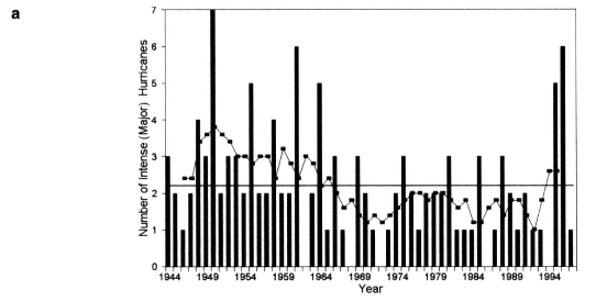
Figure 2-14
(a) Number of intense Atlantic hurricanes per year since 1944. The squares show the 5-year
running mean. (After Landsea and Gray, 1992; reprinted with permission of the American
Meteorological Society). (b) Atlantic hurricane tracks for the periods 1947-1969 and 1970-
1987. (From Gray, 1990; reprinted with permission of the American Association for the
Advancement of Science.) (c) Hurricane-related damage costs and deaths in the U.S. since
1900; damages normalized to 1990 dollars. (From Hebert et al., 1996; reprinted with permission of NOAA.)
directly related to improvements in the National Weather Service's ability to forecast hurricane tracks and intensities, as well as to improvements in the dissemination speed and coverage of hurricane warnings. The declining number of intense hurricanes has also contributed to the decrease in mortality.
In the extra-tropics, historical evidence of long-term changes in storminess is found in written records and in pat-
Page 20
terns of beach erosion and destruction in western European countries bordering the Atlantic (Lamb, 1995, and references therein). At the end of the medieval times and during the Little Ice Age—that is, essentially between the early 1200s and the late 1600s—coastal flooding and reports of other coastal damage suggest abnormally strong (in both frequency and intensity) storm activity in the eastern North Atlantic. Increases in North Atlantic wave heights since the early 1960s (Günther et al., 1998) provide evidence of more intense storminess (Figure 2-15).
These observations complement the increased frequency of reports of extremely low sea-level pressure, high wind conditions, and large ocean waves encountered at sea and along western European shores since the 1960s (Lamb, 1995). The change in ocean storminess is supported by observations of increases of the wintertime mean north-south pressure gradient across the North Atlantic since 1960 or so (Flohn et al., 1990; Bacon and Carter, 1993; Hurrell, 1995; WASA Group, 1998), and the link between the large-scale pressure gradient and wave statistics (Bacon and Carter,
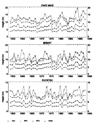
Figure 2-15
Annual wave-height maxima, means, and 99th and 90th percentiles at three North
Atlantic sites, as derived from wave hindcasts. Note that the mean remains fairly
constant, but the maxima show a marked rise and suggest a decadal pattern. (From Günther
et al., 1998; reprinted with permission of the Gordon and Breach Publishing Group.)
1993; Kushnir et al., 1997). Long-term changes in storminess have also been observed over North America (Hayden, 1981). Such changes have also been linked to large-scale climate variability (Dickson and Namias, 1976).
Sea Level
Coastal flooding by seawater inundation is one of the most direct and threatening impacts of raised sea level. This point was dramatically illustrated in 1953 when a combination of high tides and strong winds forced a local sea-level rise that inundated approximately one-sixth of the Netherlands, flooding land 64 km from the coast, killing approximately 2,000 people and leaving another 100,000 homeless (Schneider, 1997). Today, the Netherlands expends U.S. $30 million a year defending itself against such encroachment by the sea (de Ronde, 1993), in addition to the tremendous infrastructure already in place for this defense. South Florida, Chesapeake Bay, and several other U.S. locations are also losing land to immersion, including some settled islands. Sandy beaches can be especially vulnerable to a small sea-level rise, depending on the offshore depth profile. Bruun's rule (1962), which allows one to estimate beach erosion as a function of sea-level rise, suggests that a rise of 50 cm can erode approximately 50 m of beach, roughly the width of Virginia Beach. Between 1962 and 1985 the U.S. Army Corps of Engineers renourished over 700 km of beaches at a cost of $8 billion (Schwartz and Bird, 1990).
The physical effects of sea-level rise are not limited to simple inundation, however. In many cases sea-level rise exacerbates other changes (natural or anthropogenic) occurring in the coastal environment. Consequently, rising (relative) sea level affects coastal communities via inundation, erosion of land, saltwater intrusion, elevated water tables, and increased flooding and storm damage (Nicholls and Leatherman, 1994). In fact, the IPCC (IPCC, 1996b) estimates that worldwide approximately 46 million people a year experience flooding due to storm surges, and this number would double if there were a 50 cm rise in sea level. For example, consider the impact of erosion in this country due to changes in relative sea level. The Mississippi delta has the largest rate of land loss in the United States. Wetlands have been lost there at a rate of up to 100 km2 per year in this century, primarily through loss of sediment and land subsidence. Sea-level rise will only aggravate this problem.
In addition to causing direct flooding, a higher mean sea level elevates the base for storm surges, which can have devastating impacts on human life and property. For example, 300,000 Bangladeshis died in a 1970 storm surge. Sea-level rise in the Ganges-Brahmaputra delta of Bangladesh has been exacerbated by local subsidence of the land, which can exceed 20 mm per year (Alam, 1996). Higher sea level also slows rainwater drainage, leading to increased risk of riverine flooding. In September 1987 river flooding affected nearly half of Bangladesh, where population and poverty
Page 21
compound the problem—land is so scarce that people repopulate land on which the previous tenants have died in a flood. Maldives, a small island country in the Indian Ocean lying mostly less than two meters above sea level, could be totally inundated, as could numerous other small island countries scattered throughout the tropical and subtropical world.
Furthermore, saltwater can intrude landward either through the ground or up waterways, though the latter process is much more rapid. Both processes are sensitive to sea level and to the supply of freshwater at the coast. During the droughts of the 1960s saltwater advanced 53 km up the Delaware River, forcing some industries near Philadelphia to seek water imported from the Susquehanna River Basin. Today, farmers along the edges of Chesapeake Bay are losing one to two rows of corn per year to saltwater intrusion resulting from land subsidence and sea-level rise. A concern in the Netherlands is that in drought summers the freshwater needed to combat saltwater intrusion and flush the land of salt may not be available. Likewise, in Bangladesh, heavy monsoon rainfall is needed to desalinate the topsoil so that rice can be grown in a region occupied by saltwater during the dry season.
These examples illustrate the vulnerability of societies worldwide to variations in sea level. Recent analyses suggest that global sea level has been rising at a rate of 1.2-2.0 mm per year for at least a century (Douglas, 1995; Unal and Ghil, 1995), amounting to a rise of up to 20 cm. While there has been no detectable acceleration of the rise in this century, there is evidence that the rate of rise was smaller in previous millennia (Gornitz, 1995). Considerable regional variability is superimposed on the global sea-level-rise trend; some regions have experienced falling sea level (e.g., Scandinavia) and others have seen a rise larger than the global mean (e.g., the southeast coast of the United States).
Decadal-scale regional variations during this century can also be seen. Such variations are apparent in the tide-gauge records for individual locations such as San Francisco (Figure 2-16). Records like these may reflect a number of processes, including vertical movements of land, redistribution of water in the oceans, and global sea-level changes. Decadal fluctuations tend to be synchronous along long sections of a particular coast, and can sometimes be linked to wind-stress variability (Sturges and Hong, 1995). High-frequency fluctuations are often associated with local winds, though oceanic wave propagation allows a larger spatial influence (Sturges, 1987). Low-frequency atmospheric variability influences coastal sea level on longer time scales, and planetary waves can propagate these changes over very large spatial scales, influencing regions well away from the local source of the disturbance. For example, sea-level changes
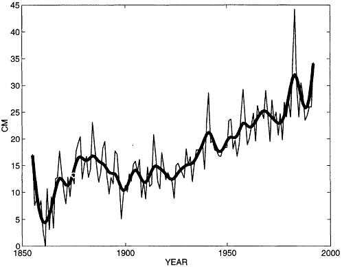
Figure 2-16
Variations in sea level at San Francisco since 1855, from data in Spencer
and Woodworth (1993). (Figure courtesy of M. Winton, NOAA/GFDL.)
Page 22
on the order of 10-50 cm are associated with the El Niño/Southern Oscillation (ENSO) phenomenon, and satellite altimetry has documented the propagation of these changes across the Pacific (Jacobs et al., 1994). At Bermuda (Figure 2-17), decadal variations on the order of 10 cm have been traced to variability of wind-stress curl over the open ocean to the east (Sturges and Hong, 1995).
Ecosystems
Ecosystems influence society directly and indirectly; our very existence depends in fundamental ways on the ecosystems of the Earth, of which we are a part. In fact, the dependence of all life forms on the physical environment, as well as their interdependence, are embodied in the concept of ecosystems, reflecting intricate communities of primary producers, grazers, and predators that are adapted to each other as well as to particular regimes of temperature, moisture, radiation, and other factors. The ecosystems in turn influence, both locally and globally, the physical and chemical environment in which they exist. For example, they moderate the flow of radiatively active gases, sequester carbon, and alter the atmospheric moisture content and the Earth's albedo; all of these functions directly influence other climate attributes. Ecosystems also influence society through other means. Our food consists of organisms taken from terrestrial and marine habitats. Ecosystems harbor the genetic diversity of life; the continuity of our food supply partially depends on the existence of wild strains that may possess resistance against emerging plant diseases and pests. Wild varieties offer the potential for higher crop yields, for new cultivars adapted to changed climatic conditions, or for entirely new crops. New medicines have often been developed from existing biological compounds.
The carriers of human illness respond to climate change when the ecosystem in which they live is affected by that change. It is believed that the outbreak of the deadly Hantavirus in 1993 in the southwestern United States was caused by a period of drought succeeded by heavy rains. The drought induced a decline in all animal populations, but deer mice, carriers of the virus, recovered far more quickly than their predators (they increased tenfold when the rains returned); this greatly increased their contact with humans (Levins et al., 1994). Coastal algal blooms, a breeding ground for the bacterium Vibrio cholera that sometimes finds its way into the food chain, have been linked to the cholera outbreak in South America in 1992 (Epstein, 1993). A threefold increase in malaria incidence in Rwanda in 1987 has been ascribed to record high temperatures and rainfall (Loevinsohn, 1994).
Other important contributions of ecosystems to our well-being are the creation of soils over thousands of years, and the establishment of an environment that is varied and enjoyable. The latter often translates directly into economic value via money spent on recreation. Soils are, of course, indispensable for agriculture, but they also function as reservoirs of water, carbon, and nutrients. However, ecosystems did not come into existence solely for the benefit of humans; they also harbor pathogens and toxic compounds, and climate-related changes in the soils may lead to changes in these threats.
Ecosystems change over most time scales. On decade-to-century time scales, there is considerable natural variability as well as anthropogenic change. For example, in southern Ontario the analysis of pollen has shown that dominant beech
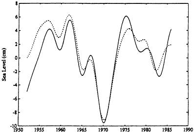
Figure 2-17
Sea-level fluctuations for Bermuda. The solid line is the observed record, adjusted to
constant atmospheric pressure. The dashed line is a hindcast made by a simple model
forced with wind-stress observations. (From Sturges and Hong, 1995; reprinted with permission
of the American Meteorological Society.)
Page 23
trees were replaced first by oak, then by pine trees, during the Little Ice Age, only a few hundred years ago (Campbell and McAndrews, 1993). Also, the monitoring of fluctuations in Northwestern salmon catch since the early part of this century (see Figure 2-18) has revealed a remarkable coincidence with decadal changes in the North Pacific sea surface temperature (Mantua et al., 1997). Decadal-scale changes in the extent of the Sahel have also been documented
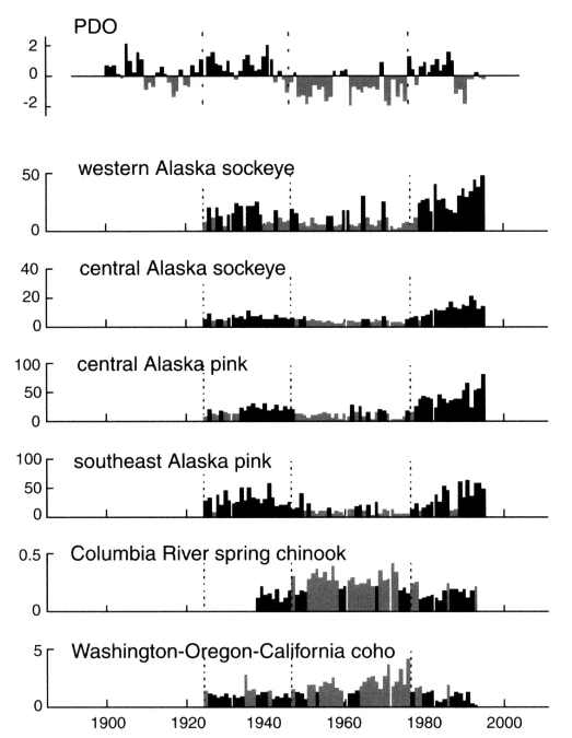
Figure 2-18
Salmon catch as a function of time, showing decadal variation in yield. The top panel shows the Pacific
(inter)Decadal Oscillation (PDO) index. The panels below show catch records for various types of Pacific
salmon. For Alaska catches, the black (grey) bars denote values that are greater (less) than the long-term
mean. The shading convention is reversed for the bottom two panels. Light, dotted vertical lines indicate
the PDO reversal times at 1925, 1947, and 1977. (From Mantua et al., 1997; reprinted with permission of the
American Meteorological Society.)
Page 24
(see, e.g., Tucker et al., 1991). Barry et al. (1995) document a shift in the community structure of invertebrate fauna in a California rocky intertidal zone consistent with observations of warming sea surface temperature between 1932 and 1993. In addition to these regional changes, the observed increase in the intra-annual amplitude of atmospheric CO2 concentration may indicate that the cycle of net primary production and respiration is increasing in vigor on a hemispheric scale (Keeling et al., 1996a).
Natural and anthropogenic habitat destruction and fragmentation are the greatest contributors to the extinction of species. Consider the entirely new ''ecosystem'' that has recently grown to occupy several percent of the land area of the United States. It is composed of a patchwork of asphalt, concrete, and structures, with some accompanying reforestation; all of these influence and are influenced by other ecosystems, society, and climate. Fire and other disasters such as floods and storms are part of a naturally varying environment to which ecosystems will adapt, but this new "ecosystem" will be more challenging.


