
1
Water and Energy Cycles
Determine and explain the annual, interannual, and spatial variations of the water and energy cycles within the Mississippi River basin.
BACKGROUND
General Characteristics
The large-scale water and energy balances of the Mississippi River basin during the period 1995–2000 will be determined and characterized in the Global Energy and Water Cycle Experiment (GEWEX) Continental-Scale International Project (GCIP) with high spatial resolution. The normal annual, diurnal, geographic, and vertical variations of surface and atmospheric balances will be defined, as will the major modes of large-scale seasonal to interannual anomalies. The accuracy of these balances will be assessed at various spatial and temporal scales.
GCIP's conceptual framework for analysis of water and energy cycling is that of a coupled land-atmosphere system. Thus, the Mississippi River basin includes not only the land surface and the earth beneath it but also the atmosphere above it. At the largest time and space scales, the cycling of water through the Mississippi basin (at a rate of about 500 km3 liquid water equivalent per year) can be viewed in three steps: (1) net inflow of water vapor through the lateral atmospheric boundaries of the basin, (2) net transfer of water from the atmosphere to the surface by excess of precipitation over evapotranspiration, and (3) river discharge from the basin to the ocean. In contrast to the water cycle, where exchange between the basin and its environment is exclusively through the lateral boundaries of the basin, the energy cycle is characterized by major radiative exchanges with the extraterrestrial environment. In addition, atmospheric heat flow convergence acts to warm the basin during the winter, and a net divergence
cools the basin in summer (Roads et al., 1997). Latent heating and radiative effects of the water substance provide strong coupling between the water and energy cycles.
The picture of net atmospheric water vapor convergence, net transfer to the surface, and runoff to the ocean obscures several important features of water and related energy cycles in the Mississippi basin. The net convergence of water over the basin is actually the difference between very large influxes over the Rocky Mountains and the Gulf of Mexico and effluxes over the Appalachian Mountains (Rasmusson, 1967). Similarly, the net transfer from the atmosphere to the surface is much smaller than either precipitation (about 3000 km3 per year) or evapotranspiration (about 2500 km3 per year) taken separately. To understand the balances, therefore, it is necessary to understand how atmospheric moisture, provided by vapor inflow and evapotranspiration, is partitioned into precipitation and vapor outflow, and how precipitation is subsequently partitioned into evapotranspiration and runoff. An analogous issue for the energy balance is the question of how the heat generated by precipitation is partitioned into radiative cooling and atmospheric heat flux divergence.
Additionally, fluxes and stored amounts of water and energy vary in space and time. Parts of these variations are regular, following the annual cycle of solar forcing in time and the physical controls of geography in space. Superimposed on these regular variations are irregular fluctuations or changes caused by the chaotic dynamics of the atmosphere-land-ocean system (e.g., the interannual variability of Mississippi River flow shown in Figure 1.1). Such chaotic behavior is generated both internally in the basin and externally (e.g., by the general circulation of the atmosphere). Storage processes within the basin modulate both the regular and the irregular variations in water and energy fluxes. Much of the internal modulation of the system response is associated with the storage of water on and beneath the land surface (Delworth and Manabe, 1989; Milly and Dunne, 1994; Koster and Suarez, 1995). In a region corresponding roughly to the Mississippi basin, the seasonal change in total water storage has been estimated to be on the order of a 10-cm depth of water (Rasmusson, 1968; Mintz and Serafini, 1981; Roads et al., 1994). GCIP will seek to describe and predict both the regular and the chaotic components of water and energy flux variations.
Geographic and seasonal variability of water and energy cycling are considerable in the Mississippi basin. Annual precipitation is greatest (about 1600 mm) in the southeast of the basin and decreases markedly toward the west, generally following the decreasing trend in vertically integrated atmospheric water content and transport. Under orographic influences, precipitation increases in the Rocky Mountains. The seasonality of precipitation varies from a weak winter maximum in the southeastern part of the basin to a strong summer maximum in the west, and these seasonal patterns follow the respective southern and western vapor inflows.
The geographic distribution of runoff is qualitatively similar to that of precipitation, which partially explains the disproportionate contribution of eastern
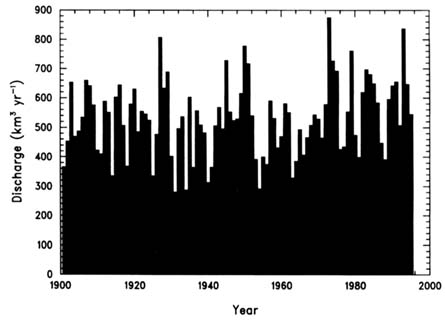
Figure 1.1 Annual discharge of the Mississippi River at Vicksburg. Co-efficient of variation = 0.22.
to the total flow of the Mississippi (Figure 1.2). In addition, the runoff ratio (ratio of mean runoff to mean precipitation) decreases from about 0.5 in the southeast to less than 0.01 in the southwest. The analogous evapotranspiration ratio ranges from about 0.5 in the southeast to more than 0.99 in the southwest. This pattern of partitioning between runoff and evapotranspiration is controlled mainly by annual totals and seasonal changes of precipitation and ''potential" (i.e., non-water-stressed) evapotranspiration (Langbein et al., 1949; Milly, 1994), the latter being determined by the surface energy balance. Over much of the basin, the seasonal distribution of runoff is consistent with the interplay between precipitation and evaporation within finite-capacity soil water reservoirs. On the other hand, in the northwest and in the western mountains, runoff peaks strongly in spring when snowmelts.
Controls of temporal hydroclimatic variability in the Mississippi basin have been the subject of much speculation and research over the years. Climate model studies have suggested that midlatitude anomalies in soil water could persist for periods of months (Rind, 1982; Yeh et al., 1984). Such model studies also suggested that North Americans soil water anomalies of sufficient magnitude and geographical extent could induce large systematic responses in computed water and energy balances. Similarly, analyses of observational data (Huang and van den Dool, 1993; Zhao and Khalil, 1993; Huang et al., 1996; Roads et al., 1997)
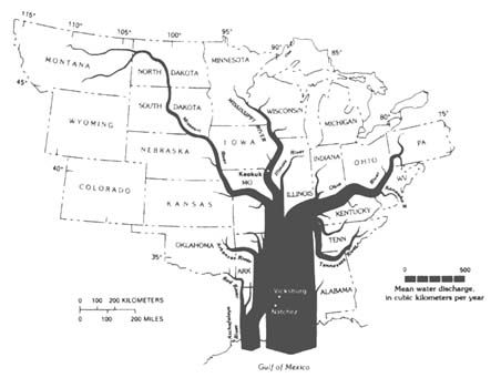
FIGURE 1.2 Mean annual discharge along major rivers in the Mississippi basin. The Ohio River, with one-sixth of the total area, contributes almost half the total flow. Relatively little discharge is produced in the west, where precipitation is lower and evapotranspiration consumes a larger fraction of the precipitation. Source: Meade (1996).
suggest that precipitation-induced soil water anomalies can cause anomalies of evapotranspiration and that the resultant variations of surface evaporative cooling directly affect surface and near-surface air temperatures.
Although the basic mechanisms of direct responses to soil water anomalies are understood, the resultant atmospheric feedbacks are more complex and the subject of great current interest in climate research. Early empirical studies identified a tendency toward persistence of summer droughts that could be ascribed to soil moisture anomalies (Namias, 1958). Recent extreme hydroclimatic events in the Mississippi basin have provided a focal point for studies of land-atmosphere interactions in the GCIP region, illustrating the complexity of the atmospheric response to surface anomalies. The heavy precipitation that caused record-breaking flooding within the Mississippi basin in 1993 has been associated alternatively with high and low soil water anomalies in different areas (Beljaars et al., 1996; Paegle et al., 1996). Physical processes invoked in the alternative explanations include surface-heating effects on the boundary layer capping inversion and associated suppression of deep convection (Lanicci et al., 1987), or influences of surface conditions on the low-level jet in the southern Great Plains. At the other hydroclimatic extreme, initially dry soil conditions in the Mississippi basin have been put forward as a possible cause of the 1988 drought (Oglesby and Erickson, 1989; Atlas et al., 1993).
On the basis of what is known about land-atmosphere interactions, it appears that atmospheric predictability associated with land surface anomalies can be significant during the warm season. Remote influences, such as tropical ocean temperature anomalies [e.g., El Niño-Southern Oscillation (ENSO)], are significant in winter over the United States and may also induce springtime anomalies of soil water that set the stage for later summer anomalies. The potential predictability of Mississippi basin hydroclimatology associated with oceanic influences will be addressed jointly with the Pan American Climate Study (PACS), which is a component of the Global Ocean-Atmosphere-Land System (GOALS) program.
Balance Equations
The conservation of water mass for the Mississippi basin (atmosphere and land combined), or for any subbasin thereof, may be expressed by
d(qa+ ql)/dt = Cq− N,
(1.1)
in which qa and ql are the total atmospheric and land water masses per unit horizontal area, Cq is net inflow (convergence) of atmospheric water to the basin, and N is net land runoff (combined surface and subsurface outflow from the area of interest). Atmospheric water includes vapor, liquid, and solid phases. Land water includes surface water (rivers, lakes, reservoirs, etc.), snowpack, and subsurface storage. The subsurface storage layer consists of a saturated zone below
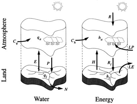
FIGURE 1.3 Major components of the land and atmosphere water and energy budgets (notation defined in text).
the water table and an unsaturated zone above. The most dynamic component of unsaturated-zone storage is water close to the surface (soil water or soil moisture), which interacts closely with atmospheric processes. For the atmosphere and land separately (Figure 1.3, left panel),
dqa/dt = Cq− (P − E)
(1.2)
and
dql/dt = (P − E) − N,
(1.3)
in which P and E are precipitation and evapotranspiration fluxes at ground level. An approximate thermodynamic energy balance equation may be written as
d(ha+ hl)/dt = Ch+ R + L (P −E),
(1.4)
in which ha and hl are the vertically integrated enthalpy of atmosphere and land, respectively; Ch is a term including net atmospheric convergence of enthalpy and its production by vertical motions; R is the net absorption (absorption minus emission) of radiant energy by the land-atmosphere system; and L is the latent
heat of evaporation of water. In general, hl includes the "cold content" of land Lfqlf, where Lf is the latent heat of fusion of water and qlf is the part of ql that is frozen. For atmosphere and land separately (Figure 1.3, right panel),
dha/dt = Ch+ Ra+ LP + H + LfPf
(1.5)
dhl/dt = Rl− LE − H −LfPf,
(1.6)
where Ra and Rl are the parts of net absorption R by atmosphere and land, respectively; H is the upward flux of sensible heat into the atmosphere at ground level; and Pf is the rate of frozen precipitation (part of P) at ground level.
These balance equations indicate the variables of most immediate concern in GCIP. However, the estimation and prediction of these terms often cannot be accomplished without more detailed information on the vertical distribution of atmospheric water content or energy fluxes, individual components of land water storage, or their spatial distributions. Consequently, GCIP cannot be limited to consideration of the lumped, large-scale quantities introduced above but must also analyze many processes at finer scales.
Diagnostic Methods
Observational estimates of atmospheric transport of water (Cq) are based on the assumption that amounts of condensed water are negligible. This is a useful assumption for the total column average, although cloud water may be relatively more important for water budgets in the upper troposphere. The vapor component of Cq has been estimated directly from measurements of the vertical profiles of relative humidity, temperature, and winds from radiosonde data (Starr and Peixoto, 1958; Rasmusson, 1967, 1971; Savijarvi, 1988). However, the radiosonde network has serious limitations in its horizontal, vertical, and temporal resolution, as well as the accuracy of its measurements. These limitations are seen in the difficulty of accurately estimating the divergence of the wind field and related vertical motions, the persistence and strength of transport by "jets" that are not resolved by the network, and the failure to sample adequately the diurnal cycle. In order to avoid some of these limitations, use has been made of analyzed fields (Chapter 3), usually by-products of the weather forecast process, which effectively combine and interpolate all atmospheric observations to yield a complete and dynamically consistent estimate of the state of the atmosphere at the time of the analysis (Sargent, 1989; Roads et al., 1994; Trenberth and Guillemot, 1995; Rasmusson and Mo, 1996). These analyses are also beginning to deal with atmospheric transport of heat (Ch) (Roads et al., 1998a,b).
Within GCIP, data assimilation methods for estimating Cq and Ch are being further developed and refined. Other sources of information, particularly for wind velocity, will be available for analyses of vapor and energy transport in
GCIP. Additional wind measurements are provided by the National Oceanic and Atmospheric Administration (NOAA) wind profiler network, which provides direct, high-resolution profiles of wind velocities, as well as the WSR-88D (Whether Surveillance Radar 1988-Doppler) velocity data that will be used to characterize low-level jets with high time and (vertical) space resolution. GCIP's innovative Commercial Aircraft Sensing of Humidity (CASH) program (Fleming and Hills, 1993), along with the GOES-8 (Geostationary Operational Environmental Satellite) radiation products, provide a link between GCIP and future EOS (Earth Observing System) era global observations.
Owing to the geometry of the surface drainage network, information on the net runoff (N) from a basin of any size may be estimated from measurements of discharge at a single river section. As of 1994, the U.S. Geological Survey's stream-gauging program routinely collected streamflow data for more than 7000 stations and possessed daily flow records totaling more than 400,000 station-years (Wahl et al., 1995). The disaggregation of the total discharge into a really distributed runoff requires additional information or modeling, for which no standard method currently exists. For this reason, water balance analyses are most readily conducted at or above the length scale of gauged basins. Additionally, not all runoff leaves a basin through the surface river network. Groundwater discharges from small basins can be significant, and this possibility must be considered case-by-case on the basis of local hydrogeologic conditions. Interbasin transport of water via pipelines, irrigation ditches, and water supply channels may also be a significant term in local water budgets.
Historically, large-scale area-averaged estimates of precipitation (P) have been based on interpolating, by various methods, point measurements from rain gauges. Precipitation is routinely observed by recording gauges at more than a thousand sites within the GCIP basin (Chang, 1981). However, simple interpolation of gauge data suffers from random sampling errors associated with the insufficient areal density of stations, particularly for convective rainfall. Additionally, systematic errors are associated with biases in the location of gauges (especially in areas of high topographic relief) and in the undercatch of precipitation by individual gauges. The new network of WSR-88D radars (Crum and Alberty, 1993; Klazura and Imy, 1993) has the potential to improve precipitation estimates by vastly increasing the effective sampling density of precipitation. Ultimately, methods will be developed that optimally combine information from both gauges and radars.
The fluxes of water vapor (E) and sensible heat (H) between the land surface and the atmosphere are not readily estimated from routine observations. Specialized equipment and technical expertise are required to obtain accurate measurements, and such measurements are representative of a horizontal length scale of no more than 100 m. Consequently, evapotranspiration must be estimated as a residual in large-scale water balance studies, using equation (1.2) or (1.3). Another approach is the use of data assimilation systems that track the state of the
land surface (soil water, in particular), computing surface fluxes in the process. Such systems can be driven by observations or analyzed fields of precipitation and surface radiation, and may also make use of discharge observations to adjust predicted land surface wetness. Whenever possible, the validity of estimates derived by balances or data assimilation must be tested, if only partially, by comparison with point measurements and theoretical estimates. In analogy to evaporation, surface sensible heat flux is not readily observed but can be derived as a residual from equation (1.5) or (1.6) or, potentially, by land surface data assimilation.
Prior to GEWEX and GCIP, surface radiation (Rl) estimates used in water and energy balance studies were typically based on empirical relations using long-term climatic means of relevant variables (Budyko et al., 1978; Henning, 1989). For the combined land-atmosphere system, satellite observations of top-of-atmosphere radiation (R) have been available for some time [e.g., from the Earth Radiation Budget Experiment (ERBE) in 1984–1987]. For the calculation of land surface and atmospheric energy balances, however, it is essential to know the partitioning of radiant energy between the land surface (Rl) and the atmosphere (Ra), as well as the temporal distributions of these quantities. The most promising technique for estimation of at least the time-varying surface solar radiation fields over the GCIP region may be to derive them from instantaneous observations of the cloud cover and atmospheric temperature and moisture profiles. Such estimates can be tested locally using direct radiative measurements. For example, the Surface Radiation Budget Network (SURFRAD) provides long-term, ground-based radiation monitoring at four widely dispersed sites in the Mississippi basin. The radiation issue is being addressed in a close collaboration among GCIP, Atmospheric Radiation Measurement (ARM), and other GEWEX projects.
Estimates of atmospheric vapor and heat storage rates (dqa/dt and dha/dt), or tendencies, are readily made in conjunction with analyses of horizontal flux convergence, already discussed. Typically, the tendency terms are much smaller than the flux terms over periods of several days or longer. Atmospheric cycling of water and energy, of course, displays strong diurnal components; consequently, the tendency terms are important in the analysis of processes at the diurnal time scale. Furthermore, diurnal variations may have a significant impact on longer-term mean values.
At time scales longer than a few days, the change of water storage on land (dql/dt) is generally considered the most significant storage term in equations (1.1)-(1.6) and provides a mechanism for monthly to annual persistence of anomalies or "memory" in the land-atmosphere system. Storage variations in the soil water zone are almost always a significant component of dql/dt, and storage changes in the saturated zone, the snow pack, and the surface water network may also be significant, depending on local hydrogeologic and climatic conditions. However, each of these terms presents unique measurement difficulties, and their
estimation is complicated by spatial variability. Some components of ql could possibly be estimated by analysis and synthesis of available snowpack data (in situ and remotely sensed), records of lake and reservoir levels, and records of water table elevations. For example, the National Operational Hydrologic Remote Sensing Center (Carroll, 1997) uses airborne measurements of surface gamma radiation to infer snow water equivalent. Unfortunately, one key term—soil water—has not been observed sufficiently to enable its accurate estimation at large-scales.
As a result of the complexities outlined above, large-scale estimates of dql/dt most readily come from water balance studies (e.g., Rasmusson, 1968; Roads et al., 1994), in which this term is inferred as a residual from equation (1.1):
dql/dt = Cq− N − dqa/dt
(1.7)
As estimates of Cq improve, so will estimates of dql/dt derived from this balance equation. Competitive estimates may ultimately be provided by data assimilation systems, especially the land system discussed in Chapter 3.
The second land memory term in equations (1.1)-(1.6) is the terrestrial heat storage term, dhl/dt. Here again, relevant measurements (soil temperature, in particular) are not routinely collected, except at scattered locations with varying protocols. Areal averaging is complicated by the spatial variability of soils, but the physics of heat storage in the soil is relatively simple and remote sensing can provide some information on changes in surface temperature. This storage term is of major importance at the diurnal time scale, when it is comparable to radiative and sensible and latent heat fluxes. Its magnitude is usually considered to be relatively small on monthly to seasonal time scales (e.g., in the computation of seasonal energy balances).
ACCOMPLISHMENTS
The GCIP strategy is to improve the large-scale data base not only with new observing systems, but also with new ways of processing available information. Data assimilation systems will improve the quality of information on such variables as atmospheric humidity and heat content, radiative fluxes, and precipitation; indeed, much progress has already been made in data assimilation system development and implementation. In addition, many model-oriented process studies supported by GCIP have already been initiated, and these will become increasingly tied to the analysis of GCIP data sets as the latter become available.
Precipitation Estimation
The Next-Generation Weather Radar (NEXRAD) network of WSR-88D radars is of central importance in the GCIP plan for observing precipitation. An
essential requirement of GCIP is to assess the value of radar-derived precipitation estimates for quantitative climatological studies. Climatological analyses of two years of WSR-88D hourly precipitation data in the GCIP large-scale area-South-west (LSA-SW) region have documented some characteristics of the estimates (Smith et al., 1996). Gauge-radar comparisons suggest that radars systematically underestimate rainfall at most sites, relative to rain gauge observations. Systematic differences found in radar-radar intercomparisons indicate that radar calibration is a problem at some sites. Contamination by anomalous propagation (errors associated with nonstandard atmospheric conditions) during nonraining periods (a major problem for the previous generation of operational weather radars in the United States) seldom appears in WSR-88D rainfall products, but contamination by anomalous propagation is still a major problem during raining periods.
Still, the WSR-88D system is superior to rain gauge networks for monitoring the space-time structure of heavy rainfall, which is essential to analyze the variability of soil moisture, evaporation, and runoff. In that regard, precipitation estimation based on GOES satellite imagery (Hsu et al., 1997) could also cover many regions where radar and gauges are unavailable (mountainous areas). It should be emphasized, though, that the accuracy of NEXRAD and satellite estimates is ultimately limited by the accuracy of gauge estimates, which are known to be affected by significant and systematic biases, particularly in snow situations. Compilation of relevant meta-data (histories of gauge type, exposure, site climate) are needed for gauge bias adjustments, which have so far been performed for about 1500 stations in the United States (Groisman et al., 1996).
The NOAA Core Project for GCIP is developing an integrated precipitation analysis combining WSR-88D, gauge, and satellite data. The current specification is that this product have a 4-km spatial and hourly temporal resolution. Unfortunately, the problems noted above must be addressed before one can produce a reliable high-resolution precipitation analysis for the Mississippi River basin. Still, preliminary versions already available on the Worldwide Web (WWW) are encouraging.
Radiative Flux Estimation
Estimation of surface radiative fluxes in GCIP is closely linked to several other projects, including several within GEWEX. One of the major tasks taken on by GCIP is the production of high-resolution radiation products for the GCIP area. These efforts have led to the production of hourly data sets for net shortwave radiation at the Earth's surface (Pinker et al., 1996; Tarpley et al., 1996). Currently, hourly estimates of net shortwave radiation are available on a 40-km grid on a near real-time basis. It is expected that this product will be valuable in the immediate future for studies of land surface process variability.
Estimation of the net surface longwave flux is considerably more difficult
than estimation of the surface shortwave flux. Longwave flux depends on cloud base height and downwelling flux at the cloud base and on the low-level profiles of temperature and water vapor. No combination of observation systems currently provides all of this information. Thus, a net surface longwave flux product must merge both observations and model-assimilated fields. This is an active area of research.
GCIP, in partnership with the National Aeronautics and Space Administration (NASA) Clouds and the Earth's Radiant Energy System (CERES) project and the Department of Energy (DOE) ARM program, supports the CERES-ARM-GEWEX experiment (CAGEX). CAGEX provides detailed in situ and satellite measurements of vertical profiles of radiative fluxes, atmospheric temperature and moisture, and cloud properties for testing radiative transfer models and satellite retrieval algorithms [particularly for use with the National Centers for Environmental Prediction (NCEP) Eta model used in GCIP], and to provide data for local hydrologic and meteorological process studies. Preliminary data from an April 1994 campaign are now available from the GCIP Project Office.
Land-Atmosphere Interactions
Preliminary results from several GCIP studies of precipitation and cloud formation processes are available. Both observational and modeling studies have explored relations between spatial or temporal variations of land surface characteristics and corresponding variations in atmospheric processes, particularly cumulus convection and precipitation.
In one particular investigation, predictions of a boundary-layer model were confirmed by observations of the development of low cumulus at two GCIP locations; the model was then used to explore the sensitivity of cloud to land surface characteristics, again with supporting evidence from GOES and AVHRR (Advanced Very High Resolution Radiometer) data (Wetzel et al., 1996). The frequency of shallow cumulus convection during summer was found to follow large-scale relative humidity gradients across the GCIP region, with smaller-scale variations correlated with elevation and the scarcity of vegetation (Rabin and Martin, 1996).
Model studies have shown the importance of mesoscale circulation patterns induced by various types of surface heterogeneities. Vertical transport of water and heat by mesoscale circulation can equal the transport by turbulence. The analysis of one model experiment suggests that mesoscale circulation induced by landscape structure may concentrate precipitation on initially drier regions and thus tend to homogenize the surface moisture distribution (Avissar and Liu, 1996). In another study, precipitation enhancement was noted downwind of the ascending air (Seth and Giorgi, 1996). A preliminary model evaluation of the
effect of land-use changes on climate in the GCIP region indicated systematic and substantial sensitivities (Copeland et al., 1996).
Atmospheric Water and Energy Transport
GCIP's regional data assimilation systems are now providing the improved analyses of atmospheric water and energy transports that are needed for further advances in understanding water cycling in the Mississippi basin. These data products will facilitate the analysis of water cycling at smaller spatial and temporal scales than have ever been previously achieved. Understanding the three-dimensional and diurnal structure of energy and water fluxes is critical for the continued development of atmospheric models at these and larger scales.
The low-level jet in the planetary boundary layer close to the Rocky Mountains has been shown to be an important factor in controlling the moisture flux convergence and its diurnal variations. This, in turn, affects the diurnal cycle of precipitation, which appears to change character from mountain areas to regions under the influence of the jet (Helfand and Schubert, 1995).
Cloud-scale motions can have important large-scale effects on vertical water and energy transport, especially during summer. For example, condensation terms in the moisture and heat balance equations have different vertical structures at small or large-scales (Roads et al., 1998b). Apparently, condensation of water vapor occurs just above the planetary boundary layer. The net heating, however, peaks higher in the atmosphere. The difference in vertical structure is associated with the interaction between vertical motions and latent heat release.
Characterization of Random Variability of Precipitation and Soil Water
Random, large-magnitude variations in precipitation complicate the tasks of analysis and prediction of water and energy balances. The spatial distribution of soil water, which is strongly influenced by precipitation, present a similar problem. For this reason, special efforts are made to characterize spatial and temporal variations in these variables. Scale-invariant descriptors of observed rainfall have been developed and related empirically to the pre-storm environment of mesoscale convective systems characteristic of the GCIP region (Perica and Foufoula-Georgiou, 1996). Studies of soil water variability have been conducted with both observed and modeled fields, which have been found to account for much of the temporal and spatial variance of Russian soil moisture data measured under natural field conditions (Vinnikov et al., 1996). Based on estimates of soil moisture distribution constructed from historical climate data and a soil water accounting model, spatial scaling properties of soil water in the GCIP have been explored (Guetter and Georgakakos, 1996).
RECOMMENDATIONS
Substantial progress has been made toward GCIP's objective of characterizing the variability of water and energy cycling in the Mississippi basin. Further progress will require increased care in the estimation of such critical variables as precipitation and surface radiative fluxes; certain other improvements in the use of available measurements could markedly enhance the value of GCIP. Rigorous investigations of local and remote forcing of hydroclimatic anomalies are needed to satisfy the GCIP objective of explaining the observed variations. Specific recommendations relevant to these and related issues are discussed below.
Develop Improved Estimates of Precipitation, Longwave Radiation, and Land Water Storage Using Existing Observational Networks
GCIP was planned with the expectation that NEXRAD would provide a high-resolution precipitation data set of high accuracy and consistency. Thus, the documented biases in WSR-88D products are a reason for concern. Because algorithms may be in a state of transition, it appears likely that improved estimates of rainfall will be obtainable in the near future by reanalysis of radar data. Polarimetric radar measurements would probably help in situations of heavy rainfall and with a variety of quality control issues. Full-scale polarimetric augmentation of WSR-88D cannot be expected in the GCIP time frame, but the necessary hardware is already in place at some sites. Research and development on its optimal use should be pursued in conjunction with work on improved WSR-88D rainfall estimation algorithms. As new algorithms are developed, the value of possible reanalyses should be assessed continually.
Radar algorithms for rainfall ultimately rely on rain gauge measurements for their development and continuing evaluation. For these and other reasons, it is essential to develop the highest-quality gauge-only precipitation data set. Data from each rain gauge should be included only if accompanied by adequate meta data characterizing the gauge site; some gauges that are used for operational applications may not meet the representativeness requirement for quantitative estimation of area-averaged precipitation, as attempted by GCIP. In this context, it is also important to adjust, where appropriate, for the bias associated with undercatch by precipitation collectors (Groisman et al., 1996); in some regions, the bias in annual precipitation measurements is comparable to the annual runoff (or equivalently the atmospheric water-vapor flux convergence). The estimation of snowfall is an especially difficult problem for GCIP. It is unlikely that useful snowfall data will be obtained from the WSR-88D during the GCIP program. At the same time, snow is the form of precipitation most severely affected by gauge biases. For the northern part of the Mississippi basin, these issues must be
recognized in the preparation of precipitation data sets and in the context of GCIP water balance studies.
GCIP has a need for estimates of time-varying fields of longwave radiation. These should be improved by processing in situ and remotely sensed data on profiles of atmospheric properties using radiative transfer models. The strong influence of clouds and water vapor on longwave fluxes presents a major challenge (Ellingston et al., 1994). Improvement in knowledge of the vertical distributions of cloud and cloud properties, water vapor, and temperature could contribute to improvements in longwave radiation estimates. Engaging the participation of other GEWEX and related research projects is important to achieve this goal.
GCIP provides an opportunity, which should be pursued, to determine whether useful information on water storage on land can be obtained independently of the atmospheric water budget. It may be possible, for instance, to derive meaningful large-scale estimates of snowpack, surface-water, and ground-water storage from operational data products; these, in turn, might provide a lower bound on the annual change in total terrestrial water storage. The remaining term of importance, water in the unsaturated zone, is much more difficult to estimate because there is no continental-scale observation network, nor are there even any standardized methods. However, such measurements do exist at scales from individual sites to state networks (e.g., Hollinger and Isard, 1994), and new sites are currently being instrumented. The challenge for GCIP is to derive meaningful large-scale storage changes from these disparate data sources.
Promote Innovative Developments and Applications of Promising Measurement Technologies That Support or Complement GCIP
GCIP is making efficient use of existing operational data sources and measurement technologies. However, it seems prudent in an undertaking of this magnitude to promote both the development of new technologies and new applications of existing techniques to the problem of environmental measurements. For example, the CASH program (Fleming and Hills, 1993) being developed for GCIP and other NOAA programs uses commercial airlines to carry moisture sensors in addition to the current, pressure, wind, and temperature sensors. These innovative measurements will be used increasingly in the future to provide in situ high-resolution characteristics of atmospheric properties.
At the surface, recent field work on groundwater lysimetry (Van der Kamp and Maathuis, 1991; Bardsley and Campbell, 1994) offers the possibility of high-precision estimates of total land water storage changes (dql/dt) by observing pressure changes in confined aquifers or aquitards (Van der Kamp and Schmidt, 1995). Given the relatively large effective horizontal length scales of such a measurement (tens of meters and higher) and the relative difficulty of alternative measurements, the value of such an independent closure of the water balance to GCIP and to hydrology in general would be extremely high.
Carroll (1997) have developed innovative measurements of the natural gamma radiation from the surface to measure the amount of snowcover. Similar efforts are being initiated to relate background gamma radiation to the amount of soil moisture. Given the difficulty in estimating the snow water equivalent from satellite measurements of fractional coverage, such measurements may prove invaluable.
The value of isotopic measurements in investigations of water history and transport is well established, but potential applications to GCIP have not been pursued. Differing isotopic compositions of water (e.g., in precipitation) are indicative of differing source regions, transport, and residence times (Gat, 1996). Investigation of the isotopic composition of water in the GCIP region could potentially yield useful information on the dynamics of large-scale circulation and its history in the region. Information can be obtained by analyses of the isotopic composition of nonexchangeable hydrogen in the cellulose of trees over the lifetime of the trees, because the isotopic record in trees reflects the record of the water they utilize (Feng and Epstein, 1996).
Useful large-scale information on soil water could be obtained in the future by satellite-based microwave radiometry. Snow water equivalent and vegetation are already being remotely sensed, although more research is also needed in this area. Any acceleration of progress in these areas could be of enormous benefit to GCIP and its follow-on activities. In the GCIP time frame, it is especially important to coordinate soil water remote-sensing research with GCIP activities, to the mutual benefit of both. Airborne microwave sensors deployed in field experiments may provide information on the time-space variability of soil water that would otherwise be unavailable to GCIP. Reciprocally, GCIP and related activities could provide in situ soil water and relevant ancillary information that will magnify the value of such experiments.
Use Observations and Models to Evaluate the Local Factors and (in Collaboration with Goals) Remote Influences That Govern Water and Energy Regimes in the GCIP Region
A major set of GCIP process issues concerns the dynamic interaction of atmosphere and land. What are the relative roles of land surface processes and remote forcing, such as ocean surface temperatures, in generating and modulating atmospheric and surface anomalies (precipitation, temperature, river discharge) in the Mississippi basin? Are anomalies in water storage and ocean surface temperatures effective predictors of atmospheric anomalies at monthly to interannual time scales? To what extent do human interventions (e.g., irrigation) influence the surface and atmospheric water and energy balances within the GCIP region? Additionally, there is a need to understand more fully the processes by which orography so strikingly controls precipitation at scales ranging from entire mountain ranges down to local orographic features. Some of these
questions will have to be explored in conjunction with other projects, notably GOALS, to maximize the efficiency of research efforts.
Use Observations and Models to Assess Quantitatively the Impacts of Individual Land Surface and Atmospheric Processes on Large-Scale Water and Energy Transport
Key GCIP process issues concerning the land environment include the identification and quantification of the factors that control evapotranspiration in the absence of water stress and the interseasonal storage of water to support dry season evapotranspiration. The influence of extensive areas of shallow groundwater, swamps, or lakes on the dynamics of water and energy balances is yet to be characterized. GCIP also provides an opportunity to determine the predictive value of standard physical soil water transport theories at GCIP scales. To what extent does the water balance manifest a nonlinear dependence of runoff on rainfall intensity, and what is this dependence as a function of spatial and temporal scales? To what extent is soil infiltration capacity a factor in the water balance? How do seasonal freezing and changes in soil structure affect infiltration and runoff? Finally, do the details of land surface topography play a significant role in the area-averaged water balance?
GCIP can also contribute to the improved understanding of atmospheric processes, complementing related studies, for example, in the GEWEX Cloud System Study. What atmospheric processes control the structure of the low-level jet over the southern Great Plains? How does cloud-scale mixing affect large-scale water vapor and heat transport? How do mesoscale circulations contribute to local precipitation and larger-scale atmospheric transport?


