
2
Coupled Land-Atmosphere Models
Develop and evaluate coupled hydrologic-atmospheric models at resolutions appropriate to large-scale continental basins.
ATMOSPHERIC MODELS
Atmospheric general circulation models (GCMs) are one of our primary tools for diagnosis and prediction of weather and climate. However, GCMs contain many approximations. The basic equations are nonlinear and must be solved via approximate numerical techniques on model grids (see Arakawa and Lamb, 1977). With current supercomputers, GCM global grids have horizontal resolution on the order of 250 km, which is inadequate to describe many small-scale features of importance to the water and energy cycles. For example, cloud-scale motions transport moist warm air upward in narrow cloud-scale regions (kilometers) and, in turn, induce large-scale compensating subsidence (hundreds to thousands of kilometers). Various parameterizations have therefore been developed and are continuing to be developed to model this small-to large-scale interaction. However, small-scale precipitation patterns important to the surface water budget and to the occurrence of floods have not yet been adequately considered. Also, GCM vertical grids do not have the capability of describing small-scale vertical features in the planetary boundary layer that influence the transport of heat and moisture from an extremely heterogeneous land surface to the atmosphere, and accurate planetary boundary-layer parameterizations still have to be developed. The interaction of cloud water with the radiation field is also highly parameterized, and various parameterizations have been developed to model this interface.
Regional models are more compatible than GCMs with the cloud and boundary-layer scales. Regional models solve the same fundamental equations as do global GCMs and have the same basic parameterizations. However, since the
geographic extent of the domains is much smaller, regional models can solve the equations at higher resolution (currently 30–50 km for most operational regional numerical weather prediction models). These regional models are usually nested in global models (or analyses), and more than one level of nesting can be incorporated. Finer-scale cloud-resolving models (CRMs) can simulate clouds with realistic representations of microphysical processes. A basic research technique in the GCIP coupled modeling effort is to use smaller-scale, high-resolution models and observations to improve the parameterizations of critical processes in larger-scale models. It should be noted, however, that climate simulations are not yet possible with CRMs because of the extensive computational requirements. GCMs and regional models will continue to play a key role in modeling long time scales and providing information about remote variations and their influence on moisture and energy transport into and out of smaller-scale models.
LAND SURFACE PARAMETERIZATIONS
Before GCIP, most of the atmospheric parameterization effort was concerned with atmospheric processes. Of great importance to GCIP, however, is how atmospheric models interact with and represent the land surface. Early GCMs did this by prescribing surface temperature and wetness, and hence the partitioning of incoming radiation. Subsequently, pioneering interactive land surface parameterizations (LSPs) were developed by Manabe (1969), and others soon followed. These LSPs were single bucket-type parameterizations, which ignored important nonlinearities, especially in the dependence of precipitation infiltration-runoff partitioning on soil moisture.
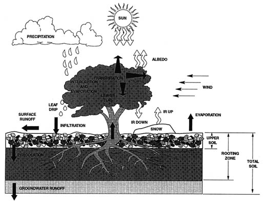
Later LSPs included vegetation effects. The Biosphere-Atmosphere Transfer Scheme (BATS) of Dickinson (1986, 1993), utilized in the early National Center for Atmospheric Research (NCAR) models, is a good example (Figure 2.1). Other models include those of Sellers (1986), Bonan (1996), and Cuenca et al. (1996). Many processes are now included in these LSPs. Just as the early weather models increased their number of levels to deal with the complexity of the atmospheric vertical structure, so too have LSP modelers increased the number of subsurface levels. This increased number of levels now allows a fast upper soil moisture layer, as well as a root zone and subsurface storage region. The vertical distribution of moisture through vegetation as well as ground diffusion are important components of the models. Also important are the vegetation characteristics (e.g., height, density, etc.) which affect variables such as interception, evaporation, radiation, and wind speed.
Although the land surface was previously thought to be important, atmospheric modelers mostly believed that it played only a minor role in climate variability. GCIP has helped to change this perception. The recent improvement in the new European Center for Medium-Range Weather Forecasts (ECMWF) model in depicting the 1993 heavy rainfall over the Mississippi and the attribution
of that improvement to the new land surface scheme (Betts et al., 1993) have also increased the atmospheric modeling community's interest in the potential influences of the land surface. However, there are still many unresolved problems with LSPs. A major problem is subgrid parameterization of processes that control surface energy and water fluxes. LSPs take into account vegetation, soils, geology, topography, and climate characteristics at each grid point. LSPs eventually also have to provide a reasonable description of runoff to allow correct GCM simulations of soil moisture and evaporative fluxes, as well as to understand the influence of climate variability on river discharge. GCIP will be of special help here through its coordinated efforts between hydrologists and meteorologists.
HYDROLOGIC MODELS
Surface hydrologic models operate at the scales needed to represent key topographic, soil, and other surface features important for runoff generation (Lohmann et al., 1998). Usually, this is considerably smaller than the smallest grid size in GCMs and even most regional models. Because of the effects of snow and soil moisture storage, hydrologic models have much longer memories than do atmospheric models. Because the hydrologic response of the land surface is strongly affected by spatial heterogeneities in topography and soils at spatial scales as small as meters, hydrologic models applicable to scales much larger than hillslopes (e.g., hundreds of meters) have not been based on direct solution of the equations of surface and subsurface flow. Instead, the current generation of operational hydrologic models (e.g., for purposes such as flood forecasting) have used conceptual representations applicable to the scale of catchments defined by stream gauges (usually of the order of hundreds of square kilometers). These conceptual models typically represent the subsurface as a series of storage zones, with nonlinear parameterizations to describe two key nonlinearities: (1) the decreasing fraction of mean areal precipitation that infiltrates, dependent on spatially averaged soil moisture near the surface, and (2) nonlinear behavior in base flow as deep soil moisture decreases during dry periods. Of the conceptual hydrologic models, the Sacramento model (Brazil and Hudlow, 1981), widely used by the National Weather Service (NWS) River Forecast Centers, is perhaps the best known example.
Although conceptual hydrologic models have been operationally useful, they have two shortcomings from the standpoint of climate modeling and numerical weather prediction. First, they are specific to individual catchments and watersheds; before GCIP, no special attempts were made to develop a continental synthesis from these kinds of models. Second, they focus entirely on streamflow prediction and do not represent surface energy fluxes in a manner consistent with atmospheric models. For example, these models ignore diurnal variations, which most atmospheric global to regional models now take into account. Conceptual hydrologic model parameters, which are not directly observable, are commonly determined through a calibration process with the objective of fitting, as closely
as possible, the model-generated runoff with observed runoff. So far, the usefulness of any distributed land surface cover data bases and remote sensing data in reducing the calibration requirements of conceptual hydrologic models has not been established.
Hydrologic models that explicitly represent topography, soils, and vegetation at the scale of digital topographic models (typically 30 or 90 m) have been developed over the past 10 years. Although these models address some of the shortcoming of conceptual hydrologic models, they have not yet been used to any significant extent for hydrologic prediction or for continental synthesis. There remain a number of important issues to be resolved before such models will be used for operational applications; the development of parameter estimation techniques is critical for their utilization.
There are important functional similarities between hydrologic prediction models and the LSPs included in general circulation and numerical weather prediction models. Both perform a water balance at the land surface. Although hydrologic prediction models generally do not perform a full surface energy balance, they do estimate evapotranspiration, which is related to latent heat flux by a scaling parameter. As indicated above, there is a distinction in that hydrologic prediction models focus on streamflow generation, whereas land surface parameterizations focus on surface energy fluxes, which in these models however also depend on variations in runoff. However, because both types model evapotranspiration, there may be an inherent inconsistency in approaches that attempt to use GCM or numerical weather prediction model output (e.g., precipitation) to drive hydrologic prediction models.
An important feature of GCIP is the attempt to bring together the diverse scales and processes represented in atmospheric and hydrologic models, and to deal with them in a common geographic and temporal framework in which all can be applied and evaluated. The atmospheric science community has begun to pay more attention to the incorporation of processes common to hydrologic models. The hydrologic community has also begun to expand the geographic extent of its models to continental-scale areas, as well as to incorporate full surface energy balances. One potential outcome of GCIP is to develop LSPs capable of predicting important hydrologic processes (especially streamflow) at continental scales and, in so doing, to provide a mechanism for updating key state variables (especially soil moisture) that control land-atmosphere moisture and energy fluxes on continental as well as basin scales.
ACCOMPLISHMENTS
Regional Focus
GCIP has provided a common geographic focus for the development and comparison of a number of atmospheric models ranging from:
-
the coarsest-scale general circulation models (GCMs) such as NCAR's community climate model (e.g., Marshall et al., 1997) and NCEP's global spectral model (Kalnay et al., 1996);
-
operational regional forecast models such as NCEP's Eta model (Black, 1994), the NOAA Mesoscale Analysis and Prediction System (MAPS) model (Bleck and Benjamin, 1993; see Figure 2.2), and the Canadian regional finite-element (RFE) model (Ritchie, 1991; see Figure 2.3); and
-
regional climate models such as MM4 (Seth and Giorgi, 1996), Regional Area Modeling System (RAMS) (Pielke et al., 1992), and NCEP's regional spectral model (see Juang and Kanamitsu, 1994).
Macroscale hydrologic models being considered under GCIP include the surface water balance models from the office of hydrology (Schaake et al., 1996) and the macroscale hydrologic VIC-2L model described by Lohmann et al. (1998).
Land Surface Parameterization Improvements
Because of GCIP, these models are being improved. For example, considerable effort has been expended in developing new LSPs for regional analysis models. The NCEP land surface scheme, which originated with the LSP scheme of Pan and Mahrt (1987), was enhanced in the Eta model (Chen et al., 1996) and has since been transferred to NCEP's Global Data Assimilation System (GDAS). Enhancements included the acquisition of land surface data bases, including monthly vegetation type, green vegetation fraction, soil type, and albedo. The Eta LSP scheme now consists of two soil layers in which soil moisture and temperature are carried as dependent variables. In addition, intercepted precipitation and dew on the vegetation canopy and water in the snowpack are now carried as dependent variables. A similar LSP model is currently being implemented in MAPS. The RFE previously operated with a simple bucket, but as a result of the MacKenzie River GEWEX Study (MAGS), the corresponding Canadian GCIP project, this bucket formulation is also being upgraded to an even more comprehensive LSP known as CLASS (see Vberseghy et al., 1993).
It is important to remember, however, that LSPs are still not equivalent to hydrologic models in simulating streamflow. It remains to be seen whether LSPs can ever truly compete with the tuned hydrologic models used in river forecasting. For example, although it would be ideal if LSP parameters could be estimated from land surface physical characteristics alone, past experience indicates that direct relationships among model parameters and land surface characteristics are elusive. Research continues to show (Duan et al., 1997; Gupta et al., 1996, 1998; Koren et al., 1996; Schaake et al., 1996, Yapo et al., 1998) that the best hydrologic simulations are achieved by calibrating these parameters using local precipitation and surface meteorological and runoff data.
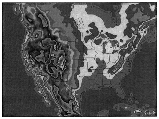
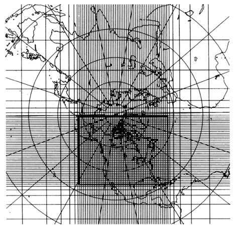
FIGURE 2.3 Variable-resolution horizontal grid of the Canadian RFE model on a polar stereographic projection. The resolution is 35 km in the central window (heavy rectangle).
However, hydrologic models and LSPs are on a converging course. In particular, new hydrologic models (see Abdulla et al., 1996) that simulate energy transfers have also made progress because of GCIP. Streamflow is now simulated in these models with an accuracy at least comparable to that achievable by the current generation of lumped conceptual models now used for operational purposes. Basically, GCIP and the other continental experiments have produced real innovations in the way regional to global models treat aspects of the land surface scheme, and the present segregation of hydrologic models and LSPs may soon be eliminated.
Project for Intercomparison of Land Surface Parameterization Schemes
GCIP helped to establish and supports the Project for Intercomparison of Land Surface Parameterization Schemes (PILPS) (see Henderson-Sellers et al., 1995), which provides a framework for evaluating LSPs. After early phases designed to evaluate certain elementary consistency measures using synthetic data, PILPS has formulated several sets of tests using local and regional observed data. For instance, common forcing data were provided at 30-minute resolution intervals for an agricultural site at Cabauw, Netherlands, for a full year. Because this was a drained field, runoff from the site is not the same as from a natural field. However, subsequent tests for a gauged catchment within the French Hydrologic-Atmospheric Pilot Experiment (HAPEX) field site provided an opportunity for the comparison of modeled and observed soil moisture and streamflow. There was a large spread between the model results and the available observations.
A new phase of the PILPS experiment is especially relevant to GCIP. PILPS 2c (Arkansas-Red River basin, or GCIP LSA-SW) will provide the most comprehensive hydrologic testing of LSPs to date. The scale of the application is consistent with the scale of numerical weather prediction (e.g., several hundred model grid cells), so some of the problems of scale mismatch inherent in testing surface fluxes with point data from land surface experiments such as the First ISLSCP (International Satellite Land Surface Climatology Project) Field Experiment (FIFE) and the Boreal Ecosystems/Atmosphere Study (BOREAS) are avoided. PILPS 2c will also provide the first real test of the hydrologic performance of the current generation of LSPs as well as the first real test of macroscale hydrologic models.
Other Model Improvements
GCIP has done more than simply improve the representation of surface climate; it has also been instrumental in generating new and improved high-resolution operational regional analysis models that better describe the atmospheric climate. Cumulus convection parameterizations are continually undergoing modifications in all regional models. The treatment of the planetary boundary layer in regional models is also being updated continuously (e.g., Janjic, 1994) using data from field experiments such as FIFE and BOREAS and from large-scale eddy simulations. The parameterization depends on the type of land surface, the flow regime (whether stable or unstable), and the closure scheme. More realistic formulations of the free convection limit and the roughness length will lead to more accurate forecasts of surface temperature and wind. More realistic surface temperature and dew point predictions should also result from refined treatments of surface evaporation, snowmelt, and soil humidity analysis over North America. With the advent of the new land surface schemes and the GCIP
data set, some of these previous planetary boundary layer (PBL) schemes will be further improved and will eventually replace the simpler schemes in global models.
Many global models still use simple relative humidity relationships to determine cloud cover. However, because of GCIP and related GEWEX research, the physical representation of clouds in regional models is being improved in operational regional models (Zhao et al., 1997). Like the FFE, the Eta model now includes a prognostic cloud parameterization scheme along with an additional predictive variable, the cloud water-ice mixing ratio, in the model's prognostic equations to represent both liquid water and cloud ice at every model atmospheric level. The model-predicted cloud water-ice mixing ratio and relative humidity are then used to estimate the cloud fraction at each model grid point. Precipitation is diagnostically calculated from the cloud water-ice mixing ratio. Calculation is done level by level, from the top to the bottom. All basic microphysical processes associated with the interactions between cloud water, cloud ice, rain, and snow are included in the precipitation calculation. The evaporation of precipitation under cloud bases is specially treated to allow the precipitation to fall, while it is evaporating, through the unsaturated layer to the ground. Horizontal cloud advection also allows the nonprecipitating condensate to be advected by the winds and by horizontal and vertical diffusion from one place to another until it evaporates.
Cloud water provides a negligible contribution to the total water and is thus ignored in most hydrologic computations; however, the contribution to the total water budget in the upper troposphere may be of interest. The predicted clouds in the Eta and RFE models are also used as input to the radiation parameterization. These parameterizations are expected to have a significant impact on precipitation and three-dimensional humidity forecasts. Energy budget calculations are expected to benefit from more sophisticated solar and infrared (IR) radiation parameterizations. Other observational programs, including Surface Radiation Budget (SRB), Baseline Surface Radiation Network (BSRN), and ARM, will be useful for providing validation data of the parameterized radiation fluxes within the GCIP area.
To summarize, the GCIP data set will contain new regional model outputs, over a basin covering most of the continental United States. Never before has so much high-resolution regional model output been available for developing a comprehensive investigation of the water and energy cycles in the atmosphere as well as the land surface over this large a continental area.
RECOMMENDATIONS
GCIP is developing some of the most advanced regional-scale models in the world. However, these advanced regional models need further development before large-scale hydrologic routing modules are included. Other parameterizations in these models, including clouds, precipitation, and radiation, also require
special attention. Systematic comparisons, such as those being carried out by PILPS over parts of the Mississippi, are important for understanding model biases. Process studies, such as the way in which the land surface affects the Great Plains low-level jet, are also important because these features are not easily observed with the current sparse observational network. Specific recommendations relevant to these and related issues are discussed below.
Further Test and Compare LSPs
Model analyses discussed in Chapter 3 will provide part of the necessary validation for modeling studies; however, these analyses are partially dependent on the analysis model itself. Many land surface processes such as soil moisture and evaporation are strongly model dependent. It is important to understand how different models treat these and other processes under similar conditions. Field programs such as ARM and Cooperative Atmosphere-Surface Exchange Study (CASES) provide additional validation for models, and GCIP should actively participate in such programs.
Land surface parameterization constitutes one of the most critical areas for controlled comparison and validation. GCIP models have to participate in experiments such as PILPS to establish performance benchmarks that could then be applied to the rest of the GCIP domain. For example, one of the new PILPS experiments will cover GCIP's LSA-SW. Given the extensive GCIP data sets for other large-scale areas, it would be of interest to promote similar comparisons in these other LSAs.
Improve Methodologies to Disaggregate Regional Model Output to the Scales of Hydrologic Processes
LSPs and hydrologic models have many parameters that are tuned to the scale of the model. For example, a GCM LSP would use different parameter values than an LSP designed to work with local historical station data; recently Gao et al. (1996) showed that current GCMs simulate precipitation with reduced intensity and increased frequency, compared to local site data. Regional models deal with drastically different scales from either GCMs or station observations. We also know that LSPs could be developed at higher resolution than the atmospheric models in which they are embedded. It may be desirable to decrease the scale of the land surface parameterization even if computational restrictions prohibit a decrease in scale for the rest of the model. Developing LSPs and hydrologic models that will work with a variety of global to regional observational data would be useful for a variety of studies. For example, Gao and Sorooshian (1994) developed a stochastic precipitation disaggregation scheme that redistributes the GCM-calculated grid-average precipitation into a subgrid scale to improve the interaction between atmosphere and land surface. However, before we
can develop scale-independent models, we have to understand the scale dependence of the input and output, as well as how to adjust these scales to give the best possible predictions.
LSPs capable of simulating streamflow, as well as state variables (soil moisture, surface temperature) and land-atmosphere fluxes, should be evaluated over the entire Mississippi River basin and its major tributaries. Complex modeling issues abound in runoff predictions. For example, the way water is partitioned into runoff and infiltration during the melting of snow and ice is a critical unresolved issue. Most LSPs follow the lead of prior-generation bucket models in effectively assuming that runoff instantly vanishes or, in some cases, goes directly to the ocean. LSPs with routing schemes that allow direct comparison of predicted and observed streamflow for major tributaries of the Mississippi would provide a unique means to validate the hydrological component of climate predictions. Limited work has been done with macroscale hydrological models, which typically operate at spatial scales compatible with numerical weather prediction or climate models. Some LSPs have attempted to take into account the surface heterogeneity in soils and vegetation as well as subsurface processes. LSP landscape features are in turn being used to describe the surface fluxes of heat and moisture into the planetary boundary layer. Runoff routing, however, is an important feature not widely present in most LSPs that deserves near-term attention.
Evaluate Model Representations of Atmospheric Mesoscale Circulations Induced by Landscape and Topography
The way in which the atmosphere interacts with the land surface is an evolving issue. Avissar and Liu (1996) suggest that mesoscale circulations induced by heterogeneous landscapes may concentrate precipitation on initially drier regions and thus tend to homogenize the surface moisture. Copeland et al. (1996) also indicate that the effects of land-use changes on climate within the GCIP region are systematic and substantial. Given the different PBL representations used in various weather and climate models, it is important to establish just how different the PBL schemes are and whether significant differences in turbulent transports occur. Comparisons of various PBL models have also begun for cloud-topped regimes (Moneg et al., 1996), and it would be useful to promote similar comparison activities for GCIP regions. A related problem is the depiction of the low-level jet (Stensrud, 1996), which is important for the transport of water vapor and heat in the Mississippi basin. This jet is analyzed quite differently by various models, especially in its nocturnal phase, which has not been well observed (Wang and Paegle, 1996). How this jet appears in different models, what its diurnal cycle is, and how important its transports are in comparison to the background large-scale transport are important scientific questions.
Improve the Parameterizations of Clouds and Precipitation in Regional Models
The scale mismatch inherent in the representation of cumulus convection in GCMs and large-scale forecast models requires that these processes be parameterized, rather than estimated explicitly. The resulting condensation and heating profiles have profound consequences on upper-level moisture and atmospheric diabatic heating processes. How should this convection be parameterized from cloud-scale models that explicitly model convection to large-scale hydrostatic models that handle convection mainly through parameterization? The GEWEX Cloud Systems Study (GCSS) (see Moncrieff, 1997) have begun to compare cloud systems over the tropical western Pacific; it would be useful to promote a companion study for the GCIP region. Scales and intensity of precipitation at the surface are also an issue. How should model precipitation be scaled to better match the characteristics of observed precipitation? How could orographic precipitation in large-scale models be adequately described?
Cloud formation and dissipation are important processes because of their effects on the atmospheric and surface energy balance. The patterns of cloud, precipitation, and surface temperatures, among properties, are generally quite inhomogeneous. How the distribution of such quantities affects radiative heating and whether GCIP models can adequately predict the distributions are unknown. The cloud modeling community has developed microphysical methods for describing clouds and precipitation. These microphysical methods are too computer intensive for large-scale models, but they have led to simpler ways of modeling clouds and precipitation that are just beginning to be incorporated into atmospheric models.


