
3
Benefits and Challenges of an Integrated Disaster Information Network
Challenges and Opportunities
The case studies described in Chapter 2 illustrate that disaster managers face a wide variety of situations, each with virtually unique requirements for information. Different types of disasters present varying demands on the timeliness of information delivery, specific requirements for base data, and needs for integration of real-time information. But the cases show the importance of being able to access data rapidly, integrate the data into appropriate information products, and deliver the products to decision makers in a timely manner.
Modern technology provides unprecedented new opportunities for fulfilling the needs of decision makers. Some information systems that are already in operation demonstrate the potential for integrating real-time data with archival information in dynamic models to arm decision makers with powerful tools. The following systems described in boxes 3-1 to 3-4, which were presented at the June 1998 Board on Natural Disasters workshop as working examples, demonstrate the power of such systems in specific applications and indicate the potential benefits that could be realized with a national or global disaster information system.
These and many other systems demonstrate the utility and power of modern capabilities for accessing and integrating disaster information. Integrated information products delivered in a timely manner have the potential to serve the needs of local, state, and federal officials; the public and private sectors; volunteers; and citizens who are responsible for disaster management or who are subject to disasters.
Emergency management is basically about managing and coordinating a complex system of information resources. The system includes addressing not only the necessary technical components for disaster response and decision-making (which is an enormous task in and of itself) but also the economic and sociological components of all phases of disaster planning.
|
BOX 3-1 Atmospheric Release Advisory Capability Improved warning systems have done much to reduce natural disaster losses by giving people more time to prepare. For a tornado a community may have an advance warning of several minutes. For a hurricane it might be several days. And although earthquakes cannot be predicted, vulnerable areas expect and prepare for them. But what about those events, disasters in and of themselves, that cannot be forseen and that can affect large numbers of people within minutes or hours? An earthquake can cause the release of hazardous substances. A sudden wind change can steer toxic gasses from a volcano toward a city. The Atmospheric Release Advisory Capability (ARAC) is a national emergency response service of the Lawrence Livermore National Laboratory that is designed to improve decision-making in just such an event. Integrating real-time data with archival information provides a powerful tool for disaster managers. After receiving just a minimum amount of information (time, location, and type of hazardous release), an ARAC response is set in motion. In less than two hours, and sometimes in minutes, ARAC will access the relevant data sources and synthesize the information to give emergency managers the probable path of the release, the extent to which it will spread, and the affected population and areas. Emergency managers can use ARAC plots and expertise to develop an appropriate response strategy to minimize hazards to life and health as well as property. The program provides support until all airborne releases are terminated, hazardous threats are mapped, and the impacts are assessed. In addition, ARAC can be used as a training tool by using actual real-time weather information to create a realistic release scenario so that authorities are ready for the real thing. Currently in use at many U.S. Department of Energy facilities, this capability could be developed for use at the state and local levels and could serve as a powerful tool for those at the front lines. |
|
BOX 3-2 Information Technology for Disaster Management EIS/GEM InfoBook Software, designed by Essential Technologies, Inc. (Rockville, Md.), is intended to provide disaster managers with an effective crisis management tool by bringing together important software. The software blends four core elements for disaster management: (1) a data administration component to put sound, comprehensive information at users' fingertips; (2) maps to help answer the questions of who, what, and where will be affected by a disaster event and identify resources for assistance; (3) models to help managers project impacts; and (4) a flexible communications component to facilitate the sharing of real-time information at a number of levels. These four components merge to provide decision makers with an accurate and complete representation of an emergency situation. Disaster managers thus have access to coordinated information from multiple sources with relative ease. The software's capabilities allow those responding to an event to make the best decisions possible. On January 17, 1994, EIS maps, data, and aerial photographs were exchanged electronically on personal computers between officials in Washington, D.C., and federal disaster offices in California following the Northridge earthquake. The real-time visual images and reports were viewed by decision makers on the local, state, and federal levels simultaneously, which helped them determine the extent of damage and speed relief efforts to the earthquake's victims. Commercially available software packages can put disaster information at user's fingertips. |
This level of coordination is difficult for individual organizations and stakeholders with limited resources, staffing, and time. An integrated national disaster information network could harness all of these components into a standardized, accessible, and user-friendly format.
Much of the information needed to create a disaster information network is already in place (see Appendix B). Federal investment in research and other programs is creating vast amounts of physical, scientific, histori-
|
BOX 3-3 New Networks in Southern California The 1994 Northridge earthquake killed 57 people and caused damages that have been estimated to be as high as $40 billion. More earthquakes of similar or greater impact can be expected in the greater Los Angeles area. To meet the threat to life and potentially devastating property losses, two new monitoring networks have been established: TriNet and SCIGN. TriNet, which is operated by the U.S. Geological Survey (USGS), the California Institute of Technology, and the California Division of Mines and Geology, with major funding from the Federal Emergency Management Agency, is an expanded and upgraded network of seismometers and strong-motion detectors. The Southern California Integrated Global Positioning System Network (SCIGN) monitors deformation of the earth's surface. Partners in SCIGN include the Jet Propulsion Laboratory, the University of California at San Diego, and the USGS, with funding from the USGS, National Aeronautics and Space Administration, National Science Foundation, and the W. M. Keck Foundation. TriNet allows rapid determination of an earthquake's location and magnitude and the distribution of strong ground motion for all felt earthquakes. This real-time and near-real-time information, broadcast to the California Office of Emergency Services and others, such as local power companies, will allow faster and better response to earthquakes. SCIGN's tracking of ground deformation is of interest to all those responsible for the integrity of major engineered structures, such as dams, water reservoirs, aqueducts and pipelines, gas pipelines, bridges, and tall buildings. Major multiorganizational networks provide real-time earthquake information for disaster managers in Southern California. |
cal, and cultural information. This information can help decision makers in the private sector and local and state governments understand hazards and the resulting risks and improve their decisions during all phases of the disaster management cycle. Potential users, other than the agency and program stakeholders for whom the information was developed, are often hampered
|
BOX 3–4 U.S. Army Corps of Engineers Data Integration program for Emergency Management The U.S. Army Corps of Engineers has developed a data integration program designed to not only pull together high-quality data sources for emergency management but also make them available to the public. ENGLink Interactive is an integrated system for communications, command, and control. Its database and mapping components allow for quick access to critical baseline and event-specific data. The data are displayed as interactive maps. One of the system's components, the Digital Project Notebook, allows users to identify a location of interest, submit a query to the database, and receive a map based on chosen criteria via a web browser. An event viewer gives users access to information on all emergency events in which the Corps is involved on global and U.S. scales, including floods, hurricanes, and other hydrometeorological events. Locator and mapping tools provide detailed information on an event location and are accessible and designed to work with popular software packages. A data integration program provides hazards information in map form for emergency managers and the public. ENGLink's capabilities have been put to use in a number of recent disasters. After Hurricanes Marilyn (1995) and Bertha (1996), maps of the U.S. Virgin Islands were created that helped identify critical features and speed response and recovery. |
by not knowing what exists or by finding it to be in an unusable form. Users often lack the capability, knowledge, or motivation to integrate this information into their decision-making processes.
Another problem is that information collected by agencies and organizations for operationally specific uses is often inconsistent with the techniques, formats, and terminology used by other agencies and organizations. The resulting mixture of inconsistent information makes use a daunting task and requires integration efforts often beyond the capability of most users. Disaster information network consensus standards would allow more effi-
cient and accurate integration and use of information. Protocols would define communications, database structure, data formatting, hardware/software requirements, networking, quality control, and other issues needed to assure the linking of users, information providers, and entrepreneurs.
Goals of a Disaster Information System
These case studies and other similar experiences suggest that the design of a disaster information system should be guided by several primary goals:
-
To improve decision-making before, during, and after emergencies through improved access to and quality of information. Losses caused by natural disasters can be reduced by taking appropriate action based on wise decision making. Therefore, the foremost consideration in designing an information system is how well it serves decision makers. To this end, a system should provide enhanced access to reliable information. Access is steadily improving through advances in computing and telecommunications technologies, and timely access is becoming less and less problematic. Technological advances are also improving reliability and speed—at decreasing costs. In addition, a system should provide robust accessibility to data and information for critical decision makers by assuring priority access in times of emergencies. This is essential for effective response and continuity of government.
Improving access to information should be linked closely with providing evaluations of its reliability. Many decision makers are not in a position to appraise the quality of information and to understand the implications of its uncertainties. An information system should address this issue and provide some measure of quality evaluation for information users. One of the problems associated with the huge increase of information available via the Internet is the need to authenticate the accuracy and currency of data as well as verify the sources providing the information. Many of the traditional mechanisms for validating information and evaluating data quality do not exist in the networked environment. This poses particular problems for the disaster management community, which requires not only rapid access information but also a high level of confidence in the integrity of the data and information received. Addressing this issue will require a combination of organizational mechanisms that can develop criteria for quality standards and technical approaches, such as digital certificates that can verify sources of information and validate content.
The increased availability of information and its standardization, agreements on protocols, and increased linkage to users nationwide should stimu-
- late a market for entrepreneurs to develop tools for user-specific purposes. Tools may include on-line search engines, data integration routines, loss estimation software, and event description models that integrate appropriate information for decisions. These tools might also include quality assurance routines analogous to filtering software to ensure information reliability. While a private nonprofit organization in cooperation with government agencies may sponsor the development of selected tools for specific users, the information system should empower entrepreneurs to create innovative user-serving products and tools with commercial value.
-
To provide information products that are specifically designed to meet the needs of users. Most existing information resources on disasters were designed for specific purposes, in many cases related to research and development studies. Over time the broader utility of these resources has been recognized, and efforts have been made to draw on them for a wide variety of needs. The disaster management community, one of the critical users, has had mixed success in this endeavor because the data and information were not necessarily developed with this group of users in mind. In developing a disaster information network it is essential to focus on users' needs and give foremost priority to structuring and formatting the system to deliver products specifically designed to facilitate decision making.
It is important to recognize the diversity of users' needs and to tailor products accordingly. The needs of public or private emergency managers, land-use planners, insurers, and facility operators, for example, are specialized and different. Users' needs should probably be identified on a sector-by-sector basis, with a coordination mechanism to link each sector with the relevant information providers. Many of the information providers who are funded to create the data for research purposes will need incentives to modify their data and provide distribution facilities for emergency managers.
Systems should be designed to allow multiple products to be generated from common datasets and to provide on-demand capabilities for customized information. Search technologies that enable both novice and sophisticated users to query the same database also can contribute to serving diverse user communities.
- To promote efficiency and cost effectiveness. The various data and information resources that can be utilized for disaster management have come into existence for a wide variety of purposes and with many different funding arrangements. The continued viability of these resources requires that they remain tied to the organizations that nurture and sustain them. The fact that these resources are distributed no longer presents an obstacle to incorporating them into a system for disaster management, owing to the
- capabilities of the Internet. Integrating the various data and information resources would not only provide new decision-making products but also do so in a far more efficient manner than if the various resources were to proceed separately. Through common formats and standards, information could be shared and duplication avoided. Organizations would no longer have to collect certain types of data since they could access the data remotely from another source. Interactions among the various user sectors would be enhanced, leading to the sharing of applications.
Of critical importance, the creation of an integrated disaster information system would establish a framework that would encourage organizations and individuals to develop integrative products because a larger market would exist for them.
-
To stimulate and facilitate mitigation. As computing and communications technologies are integrated into all functions of government at the local as well as state and federal levels, emergency management will be radically transformed. Wireless technologies will provide mobile communications that facilitate government's ability to track functions on a continuous basis, wherever they are located. Combined with enhanced wire communications and the integration of disparate databases, municipal management information systems will be capable of monitoring and synchronizing various activities across government agencies and departments.
An integrated information system would provide a process by which all levels of government could link information resources. The larger, more technologically developed jurisdictions could use the system to integrate local resources in a more cohesive way. Smaller underfunded jurisdictions will have available at a more reasonable cost information and tools to assist in decision making. Similarly, the network could allow nongovernmental entities to have access to an integrated information base to better support emergency management decisions.
Challenges in Providing Information for Decision Making
In developing a disaster information network, a number of considerations are important with respect to providing information on the nature of a hazard, the potential losses that may result from impending and future disasters, and the development of strategies for reducing this damage. It is critical that those who provide information be aware of the concerns and limitations of those who receive it. Furthermore, interaction of the various interested parties depends on the type of information available, how it is presented to them, how individuals process the information, and the con-
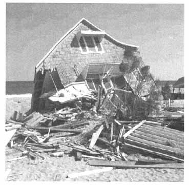
Some beachfront property became uninhabitable due to damage from Hurricane Fran in 1996. (Photo courtesy of FEMA.)
text in which they make their decisions. It is also important to understand how choices are made when dealing with problems that involve risk and uncertainty. Discussed below are some issues related to these considerations that need to be addressed in developing a disaster information network.
Types of Data Made Available to Users
Advances in information technologies have made it possible to perform disaster modeling that simulates a wide variety of different scenarios reflecting the uncertainties of different estimates of risk. For example, it is now feasible for insurers to evaluate the impact of different exposure levels on both expected losses and maximum possible losses by simulating a wide range of different estimates of seismic events using data generated by scientific experts. Similar studies can be undertaken to evaluate the costs and benefits of mitigation measures. However, the growing number of disaster models presents many challenges to users who rely on these models to estimate risk or potential damage. Each model uses different assumptions,
different methodologies, different data, and different parameters in generating estimates of risk and damage. There is a critical need for a better understanding of how and why these models differ and for reconciling the differences in a more rigorous manner than has been done to date.
The interaction of different information users depends on the type of information available and how it is presented, how the information is processed, and the programs and policies that are in place. There is a growing empirical literature which shows that individuals utilize information in ways that are often different from what is considered to be rational by theories of choice. Unless one understands what types of data are collected in addressing a particular problem and how the data are utilized by the concerned individuals or groups, a proposed set of strategies is not likely to perform in the way that would be predicted by these theories. For example, if individuals in floodplain areas believe that their properties will not be damaged during their lifetimes, they will not voluntarily purchase flood insurance even if the rates are highly subsidized.
It is important to determine the types of information that should be presented to potential users on what scientists know about the risks associated with specific natural hazards (e.g., the probability of a particular disaster occurring, the nature of the losses with and without specific mitigation measures). In this regard it will be necessary to decide how best to present information to users that reflects disagreement among scientific experts on the risks of the hazard and the costs associated with specific strategies for reducing losses. Information and strategies that are robust over a wide range will be most useful to decision makers.
Tools and Products for Integrating Information
There are often very high costs associated with collecting data on any specific hazard. For this reason there is a tendency to maintain the status quo, which sometimes can be positive, such as if one chooses not to develop a piece of land in a hazard-prone area. Other times change may be needed. In this case it is important for those providing information to understand what information a user will need for a particular decision and how reducing the cost of obtaining the data may aid this process. With new information technologies it is easier to collect information, but there is considerably more data from which a particular user can choose. The scarce resources for decision makers today are attention and time rather than data. The data must be converted into relevant and timely information. It is important to understand how individuals are likely to make choices when dealing with decisions that involve risk and uncertainty. By understanding
the decision-making processes of individuals and groups (i.e., their probability biases and simplified decision rules), it is possible to design better decision strategies that are likely to achieve the desired objectives.
Methods should be developed to utilize systematic approaches, such as cost-benefit analyses, to enable decision makers to evaluate alternative strategies for reducing losses. New information technologies, such as the World Wide Web, should be used to determine what information decision makers think is important to consider in specifying and evaluating different strategies. This will enable the capture of sets of costs and benefits that might not otherwise be considered in dealing with a specific problem. Tools and products need to be developed and evaluated for updating data on costs, benefits, and strategies as new information becomes available.
Improving Utilization of Disaster Information for Decision Makers.
It is vital to determine what information specific decision makers would like to have available for evaluating and implementing specific strategies for loss reduction. Methods need to be found for incorporating the decision-making processes of the key interested parties in developing relevant strategies for reducing losses. Ways need to be found to use new technologies to get feedback on how useful specific information is likely to be to decision makers and how useful it actually has been. How can one use a disaster information network to determine what additional information might be useful over time? It is also important to communicate the “success stories” of communities or regions to others so that they can learn and build on those experiences.
Recognizing Nested Decision-Making Structures
In setting up a disaster information network, it is important to recognize that a change in any given policy must be carefully structured to reflect the formal and informal institutional arrangements and the nested decision-making structure between stakeholders. Each interested party has its own set of values and agendas that influence the way it processes information and interacts with other groups. To illustrate the nested decision structure, consider the challenges associated with reducing disaster losses through mitigation measures. Relatively few property owners adopt loss reduction measures even if they are relatively inexpensive and promise to yield sufficient benefits to justify the cost. One solution to this problem is to provide individuals with information concerning the dangers of living in specific areas. Other stakeholders have good financial reasons not to implement this
|
BOX 3–5 Taking Predisaster Measures Providing better information alone may not reduce disaster losses. It may be necessary to combine the dissemination of information with other strategies such as economic incentives, regulations, and standards. For example, insurance premium reductions for adopting loss reduction measures should encourage property owners to seek information on cost-effective mitigation measures. Clearly specified building codes should encourage property owners to get information through inspections on whether the standards have been met. This information could then be made available to other interested parties such as the property sellers, insurers, mortgage holders, and public-sector agencies at the local, state, and federal levels. Information is a powerful resource to be used in conjunction with mitigation measures to reduce risk from disasters. The failure of information alone to solve the problem of reducing disaster losses is evidenced by the lack of interest of many individuals in voluntarily purchasing property insurance and adopting mitigation measures. Many residents in hazard-prone areas think that a disaster will not |
measure. For example, property sellers have no reason to provide prospective buyers with information on the hazards associated with living in a particular structure that fails to meet the building code. They are supported implicitly by current owners who want to sell the property at as high a price
|
happen to them even though scientific analysis suggests some likelihood that structures will be damaged, some severely, in the next 5 to 10 years. If people perceive the probability to be below a given threshold level of risk, they are not likely to worry about it and hence will think that it is not necessary to protect themselves against the event. Following disasters there is an increase in the demand for insurance protection because the event is salient in many people's minds, so that its perceived probability exceeds the threshold level of concern. The factors that determine the demand for insurance protection are still not well understood, although recent controlled experimental studies provide some insight into consumers, decision-making processes. There is evidence that presenting information in different forms may affect how consumers determine whether to purchase insurance coverage and how much to pay. Some of these effects are the vividness of a projected event as portrayed by the news media and the use of rebates so that a policyholder thinks that he or she has experienced a gain if he or she does not collect on the policy. Data from insurance markets suggest that these same effects occur when similar real-life decisions are made. Findings from the laboratory and the field suggest that the theory of consumer choice regarding insurance needs to be rethought and factors influencing the decision-making process should be considered when determining what information to present to those at risk. |
as possible. Furthermore, a potential buyer may have little interest in understanding a structure's design if he or she is not convinced of the risks associated with future disasters. These interacting self-interests and nested decision-making structures must be taken into account in effective dissemination of disaster information.


