
Page 18
2
Climate Forecasting and Its Uses
This chapter examines recent and expected developments in the scientific capability to make seasonal-to-interannual climate forecasts and discusses the types of forecasts that are likely to be socially useful. As background for readers unfamiliar with climate forecasting, we begin by discussing the distinction between weather and climate and how climate forecasts are made.
Weather and Climate
We are all familiar with the progression of the weather. Every few days, the temperature changes, rain comes and goes, or a severe storm hits. The characteristic time scale for changes in weather in the mid-latitudes is a few days or less. In the tropics, especially over the ocean, the weather tends to be much steadier, with sunny weather and steady trade winds punctuated by an hour of daily downpour (usually in the late afternoon) or by a squall every few days.
We are also intuitively familiar with the concept of climate: we recall an especially warm summer or an especially snowy winter. The definition of climate is in accord with our intuitive concept: climate is the statistics of weather averaged over a time period that contains many weather events, usually at least a month. The mean summer temperature (the temperature taken every day for 90 days during the summer and then averaged) is a climatic quantity, as is the mean February rainfall. The characteristic time scale of climate is therefore a month or longer.
Page 19
Climatic means can be changed in two distinct ways: by a small change acting over the entire averaging period or by a changed number of extreme events within the averaging period. Thus a summer can be especially hot if the daily temperature is hotter every day during the summer or if there are, say, three heat waves instead of the usual two. Extreme events therefore contribute in an important way to climatic means but the events themselves are weather, not climate.
Other climatic statistics include the variances of quantities averaged over the climatic period. For example, two winters with the same mean temperature may differ in that one has a wider range of maximum and minimum temperatures. Orange growers in Florida would certainly be more concerned by a winter in which the lowest daily temperatures often went below freezing than a winter in which they did not, even if the mean winter temperature were the same for both.
The climatic statistics for a given month (say December) are not the same each year. When there is significant variability of December averaged temperature from year to year (compare December 1982 with December 1983, say), the climate is said to vary interannually. Although a certain amount of interannual variability is intrinsic to any monthly averaged process (the time average over any varying short-term weather process will vary depending on the statistics of the weather process), there are global patterns of interannual variation that have characteristic properties in space and time.
The strongest known pattern of interannual variability in the earth's climate system is El Niño/Southern Oscillation (ENSO): it consists of both a warming and a cooling of the waters of the equatorial Pacific Ocean occurring irregularly every few years and a concomitant set of worldwide climatic changes that statistically depend on these changes of sea surface temperature in the equatorial Pacific. A detailed description of the ENSO phenomenon appears in National Research Council (1996a) and a simple description may be found on the web at <http://www.pmel.noaa.gov/toga-tao/el-nino/home.html>. The regions affected by ENSO are shown in Figure 2-1. Although ENSO is the strongest known interannual signal, it is not the only one. A region may have interannual variability for reasons that may or may not include ENSO.
How Seasonal-to-Interannual Climate Forecasts Are Made
The Weather Forecasting Paradigm
Society has come to take for granted the benefits of weather of forecasting and is accepting of the considerable costs incurred to make the fore-
Page 20
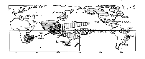
Figure 2-1.
Typical rainfall and temperature patterns associated with the
warm phases of ENSO conditions for the Northern Hemisphere winter
season.
Source:
http://nic.fb4.noaa.gov/products/analysis_monitoring/impacts/warm.gif
,
based on Ropelewski and Halpert (1987) and Halpert and Ropelewski
(1992).
casts. Weather forecasts are useful, in perception and in fact, and their usefulness makes them valuable.
Weather forecasts, a prediction of the state of the atmosphere a few days in advance, are made in various countries using standard procedures. Upper air and surface data are collected in standard formats from balloons, airplanes, satellites, and surface stations and transmitted to the Global Telecommunications System (GTS), where they become accessible to all national weather services. Crucial to the data enterprise are global coverage and the free distribution of the data. These depend on the ability of the poorer countries of the world to maintain upper air stations and on the willingness of all countries to make weather data available freely.
The quality of the collected data is controlled by a variety of means: simple consistency checks, location checks, gross agreement with previous data, gross agreement with previous forecasts, and comparison with other data. Because the data are taken at different times within the weather forecast window (usually three to six hours on either side of 0 and 12 o'clock Greenwich Mean Time), the data are time interpolated to standard times.
The data are assimilated into the atmospheric forecast model and the optimal estimate of the current state of the atmosphere is made. This optimal estimate, or ''nowcast,'' is an analysis of the current state of the atmosphere, not simply a collection of observations: observational data alone are too sparse to define the atmospheric state adequately for initial-
Page 21
izing forecasts. The nowcast may be thought of as interpolating in space and time dynamically consistent model data to augment the limited amount of observational data available.
The forecasting model is initialized. The initial atmospheric state is estimated in creating the nowcast, but additional constraints may be needed so that the model may be run efficiently. In particular, certain boundary conditions need to be known (these are more slowly varying conditions at the boundaries of the atmosphere, in particular the lower boundary, that determine the statistics of the atmosphere). These boundary conditions are the sea surface temperature, sea ice coverage, land ice, snow cover, the amount of vegetation cover on land, and soil moisture. Starting from the nowcast and the initial state of the forecast model, the atmospheric model is run for a time (usually 10 days) and the forecasts for all times up to 10 days from the initial time are made. The skill of the forecast is evaluated after the fact by comparing the nowcast of the atmosphere at a given time with all the forecasts made of its state at that time.
Because the atmosphere is a chaotic system in the mathematical sense (i.e., it is very sensitive to changes in its initial conditions), there is an ultimate limit of predictability, determined by the rate at which the inevitable errors in estimating the initial state of the atmosphere grow. This ultimate limit has been determined to be on the order of two weeks (Lorenz, 1982; a popular account of the chaotic nature of the atmosphere and the two week predictability limit may be found in Lorenz, 1993). No matter how precisely the initial state is estimated, the precise state of the atmosphere cannot be predicted more than two weeks in advance.
Weather forecasting by numerical means began in 1948 and rapidly expanded. Global forecasts are currently made by public agencies (at least in the United States) from publicly gathered data and disseminated publicly. A multibillion-dollar private weather forecasting industry has grown up in the United States that provides specialized weather services to a variety of private sources. These services usually involve providing specific information to specific sectors of industry to guide resource growth, distribution, and allocation.
What Is Seasonal-to-Interannual Climate Forecasting?
Seasonal-to-interannual climate prediction grew out of the international Tropical Ocean Global Atmosphere program. A history of seasonal-to-interannual climate prediction and an recent assessment of the status of the field is given in National Research Council (1996a).
Page 22
Why Is Climate Predictable?
If weather is predictable for only two weeks in advance, how can climate be predictable at lead times of months to a year or two (i.e., on seasonal-to-interannual time scales)? The definition of climate provides an answer to this question and also shows the path toward prediction: "Climate" refers to the statistics of the atmosphere. The atmosphere interacts strongly with the surface through the interchange of fluxes of heat, momentum, and water. The climatic state of the atmosphere therefore depends strongly on the state of the surface, which can be characterized by its temperature, reflectivity, and surface moisture. Because of the interaction of the atmosphere with the surface, the surface conditions will generally change, in turn causing the atmospheric statistics to change in response. The evolution of the climate is therefore dependent on the boundary conditions at the surface with which the atmosphere interacts.
Among the more important statistics of the atmosphere are the averaged temperature and the averaged precipitation (the average must be taken over several time scales for weather systems—usually a month or more). In general, we want to predict monthly averaged temperature and precipitation. We also want to predict the variance of these quantities in order to have some indication of changes in the number of extreme events during the averaging periods and of how much reliance should be placed on predictions of the averages. Since the statistics of the atmosphere depend on the boundary conditions, the key to predicting these statistics is predicting the boundary conditions.
How Have Climate Forecasts Been Made Previously?
There is a long history of trying to predict the climate, just as there was a long history of weather prediction before the advent of numerical weather prediction. There are traditional methods of forecasting: by divination, by perceived patterns (e.g., a perception borne of experience that, in a given region, a warm summer follows a cold winter), by precursors (the appearance of wooly bear caterpillars are followed by cold winters), and by other traditional means (e.g., The Farmer's Almanac).
This century has seen the development of statistical forecasting techniques, both univariate (e.g., predicting the rain in terms of the past history of rainfall) and multivariate (predicting the rain in terms of other quantities that seem to correlate with the rain, such as temperature and pressure). These methods are still in widespread use, but, when directly compared with numerical model predictions (described below), they generally have lower skill at shorter prediction lead times. For reasons described below, the numerical methods are limited by the availability of
Page 23
ocean data (as well as by other considerations) so that prediction by statistical methods is sometimes the best available (sometimes the only available) prediction for a given region.
How Are the Forecasts Made by Numerical Models?
The essence of climate prediction is predicting the evolution of the surface boundary conditions and the atmospheric properties with which they interact. In general, some aspects of the surface change slowly (e.g., sea surface temperature, because of the immense heat capacity of the ocean) and some change rapidly (e.g., surface moisture). Sea surface temperature provides a convenient example of how climate forecasts are made, and the basic idea applies for the other boundary conditions as well (sea ice, land ice, snow cover, soil moisture, vegetative cover, etc.). The key difference between the mechanics of weather prediction and the mechanics of climate prediction by numerical methods is that climate prediction involves the interaction of the atmosphere with a more slowly varying component—in the case of ENSO, the ocean. Climate prediction (of sea surface temperature) is distinguished by the need for initial data from the interior of the ocean, and it is this slow ocean component of climate that carries the information forward in time and allows a prediction over time scales longer than weather time scales. Climate scientists say that most of the "memory" of the climate system is in the ocean.
Sea surface temperature is determined by fluxes (exchanges of heat and momentum) from the atmosphere and by heat transported by motions in the ocean. In turn, sea surface temperature helps determine the fluxes in the atmosphere. The only way to keep track of these mutually dependent interactions and to predict their course is with a model that consistently couples the atmosphere to the ocean: a coupled atmosphere-ocean model.
Sea surface temperature is predicted by following a series of steps: First, data are collected in the ocean and combined with the atmospheric data routinely gathered for weather prediction. As of 1998, there are a variety of instruments sparsely deployed in the ocean, most of which provide data that are reserved for research before they are released for public use. The so-called ENSO Observing System is different. It collects data specifically to predict the sea surface temperature in the tropical Pacific where ENSO holds sway; the data are transmitted in real time (i.e., as soon as possible after the observations are taken) to the Global Telecommunications System in a manner similar to weather data.
The centerpiece of the ENSO observing system is the Tropical Atmosphere/Ocean (TAO) Array, which transmits data over the Internet (http://www.pmel.noaa.gov/toga-tao/realtime.html). The TAO Array
Page 24
consists of 70 stationary platforms moored to the ocean bottom by 5 kilometers of nylon and kevlar line. Each surface platform measures winds, humidity, atmospheric pressure, and the sea surface temperature. Attached to the line are a series of instruments that measure the temperature and pressure at intervals down to 500m below the surface. The entire observing system for the tropical Pacific can be viewed at http://www.pmel.noaa.gov/toga-tao/noaa/elnino.html and is described in National Research Council (1994). The ocean data are quality controlled by a variety of checks.
Second, the ocean data are combined with the atmospheric data to provide an estimate of the initial state of the coupled system. In practice, the time scales of the atmosphere are short compared with those of the ocean so that the surface winds and subsurface temperatures (at various depths) are assimilated into an ocean model to gain an estimate of the initial state of the ocean alone. The atmospheric state is estimated from the analysis performed for weather prediction. This gives an initial state for the coupled atmosphere-ocean system.
Third, starting from the initial state, a forecast is made. The coupled system is allowed to evolve freely for a given lead time and the forecast is the state of the coupled model after that lead time. Sometimes the initial atmospheric state is not known even though the ocean initial state is known, so that an ensemble of forecasts is made starting from various possible atmospheric initial states. This approach provides an envelope of possible forecasts, and, from the distribution of the final ensemble members, an estimate of the uncertainty of the forecasts. Finally, the forecast is evaluated by statistically comparing the forecast state with the analysis of the current state at the time for which the forecast was made, due regard being paid to the uncertainty of the current analysis.
The forecasts are made at ranges of months to years, so that, for each forecast made, it would normally take months to years to find out to what extent it proved accurate. It is therefore very cumbersome (basically impractical) to develop forecast systems by waiting for the many forecast-analysis cycles needed to evaluate a system. For example, since the first successful ENSO forecast by a coupled atmosphere-ocean model (Cane et al., 1986), a forecast every month would yield a total of only about 120 forecasts. By contrast, since numerical weather prediction was developed in 1948, over 20,000 forecasts have been made. To develop prediction systems more efficiently, past data are used to initialize the state of a model and "forecasts" are made of events that have already occurred and scored by data already in hand. These retrospective forecasts are called "hindcasts."
We do not want to leave the impression that the only way to forecast is with numerical coupled models. Statistical methods are routinely used
Page 25
to predict quantities of interest when other methods are not available. Statistical methods depend on correlations between predictors (the quantities used to make the prediction) and the quantities of interest (predictands). For example, the rainfall in the Nordeste region of Brazil (the predictand) correlates with sea surface temperature in both the tropical Pacific and subtropical Atlantic (the predictors), and statistical forecast schemes using both of these these predictors have proven useful in predicting rainfall in the Brazilian northeast (e.g., Hastenrath, 1990; Uvo et al., 1998). When the predictors are correctly chosen (including, perhaps, internal ocean data) and the relationship between the predictors and predictands is simple and direct, there is no reason that statistical methods would not have as high a skill as numerical methods. In general, numerical models contain most of the processes in the atmosphere and the ocean and keep track of them in a consistent way. Thus, they have the potential to provide more accurate and complete information. However, there is no reason that statistical methods that keep track of all the predictors should not have a comparable skill to numerical methods. Which method is preferred when both are available is judged by the skill of prediction.
Which Quantities Are Forecast?
Scientists forecast sea surface temperature (SST) by numerical methods, but, in general, it is temperature and precipitation over land that people most want to predict. At the moment, only SST in the tropical Pacific Ocean characteristic of ENSO is forecast; however, because ENSO has such a global influence, forecasting tropical Pacific SST has predictive value for temperature and precipitation in many specific regions around the world (Figure 2-1). We emphasize that forecasts of ENSO predict a physical quantity, the SST. When the SST in the tropical Pacific is predicted to be anomalously high, it may be said that forecasters have predicted El Niño, but since this term has no agreed-on definition in terms of value of SST, this is an interpretation. The key is that the value of SST is predicted and the value of the forecast resides in the consequences of the predicted value of SST. The statement that El Niño has been forecast is a journalistic rather than a scientific statement.
In the tropics, atmospheric circulations are driven directly by the latent heat released in regions of persistent precipitation. Thus in the far western Pacific, the normal persistent rainfall is accompanied by rising motion and lowered surface pressure. In the eastern Pacific, the circuit is completed with downward motion, lack of precipitation, and higher surface pressure. These regions of persistent precipitation can emit planetary waves, which propagate to higher latitudes and affect local circulations
Page 26
and rainfall. The role of tropical SST is to determine the locations of these regions of persistent precipitation, which, in general, lie over warmest waters. When SST in the eastern Pacific increases (during warm phases of ENSO), the regions of persistent precipitation expand eastward into the central and eastern Pacific and may affect the west coast of South America while moving away from the western Pacific, causing droughts in the normally wet regions around the Indonesian archipelago. This motion of the regions of persistent precipitation affects higher latitudes similarly, but less robustly.
In the vicinity of the tropical Pacific, where the variability of temperature and precipitation is low, knowing tropical Pacific SST translates directly into knowing average temperature and precipitation over land. Peru, Ecuador, Chile, Australia, and the Pacific Islands use these forecasts directly to plan their agriculture and water management. In the midlatitudes (for instance, the Pacific Northwest of the United States), where weather variability is high, knowing tropical Pacific SST allows prediction of shifts in the probable averages of temperature and precipitation, but the information must be used with care since there is so much variation around the averages. In such regions, it requires a certain sophistication to use the information effectively. For example, it can be useful to have estimates of the likelihoods of particular outcomes at some variance from the predicted average.
How Are the Forecasts Evaluated?
An objective measure of the skill of a series of forecasts is defined by comparison of a quantity forecast with the quantity observed at the forecast time. For example, if the quantity forecast is the NINO3 index (the SST spatially averaged over the eastern tropical region 90°W to 150°W, 5°S to 5°N), then records of forecast and observed NINO3 would be correlated and a single number, the correlation coefficient of the two time series, would represent the measure of how accurate, on the average, the phasing of the forecasts has been. Similarly, the root mean square (rms) difference of the values in the observed time series and the values in the forecast time series would indicate how accurate, on the average, the amplitude of the forecasts has been. These two numbers, the correlation coefficient and the rms error, then give objective measures of how good the long series of forecasts has been.
We emphasize that these measures of skill apply only to long series of forecasts, not to an individual forecast. In order to think about the accuracy of an individual forecast, we must think of the individual forecast as a probability of occurrence. To oversimplify, if the forecast system exhibits an averaged correlation coefficient of .8 over a long series of forecasts
Page 27
at a given lead time, all we can say about the next forecast at that lead time is that the probability of the system having the predicted phase (positive or negative) is 64 percent. The meaning of this probabilistic forecast must be understood as the averaged number of correct forecasts over a long series of forecasts.
How Good Are the Forecasts?
The perfect forecast for a series of forecasts of NINO3 would have a correlation coefficient of 1.00 and a rms error of 0.00. Needless to say, perfect forecasts do not exist. Figure 2-2 shows the correlation coefficients and rms errors from a long series of forecasts using the Cane-Zebiak model (Chen et al., 1997). The heavy black lines correspond to persistence—that is, the forecast that any initial SST anomaly would remain constant. Persistence provides a good forecast for a few months—in fact, it is hard for any existing forecast scheme to outperform the forecast of persistence over this time scale. The coupled forecasting model has a rather large nowcast error that arises when the models are coupled: the ocean data generate surface winds in the model that are slightly inconsistent with the observed surface winds. The nowcast error can be decreased by better initialization. The difference between the dashed and solid thin lines in Figure 2-2 are due entirely to different initialization procedures. The figure shows that the better initialized model offers real predictive skill above persistence in predicting NINO3 for at least 12 months. Similarly, the rms error of the better initialized model is below that of the persistence forecast for more than 12 months. Similar considerations apply to other coupled models. The general issue of initialization and the correction of nowcast error is a difficult problem in climate prediction and is not unique to the Cane-Zebiak model.
Whether or not this degree of skill is enough depends entirely on the use to which the forecast is being put: the usefulness of skill is subjective. Scientists usually consider that correlations above .5 or .6 (indicating that 25 to 36 percent of the variability is predicted) offer a useful degree of skill, but different uses, and similar uses in different regions, probably require different degrees of skill to be useful.
Because the skill increases with decreasing forecast lead time (Figure 2-2), and because a forecast is made every month, the forecast is updated as the forecast time approaches. The closer we are to the forecast time, the shorter is the lead time and the better the forecast. This updating and improvement of the forecast with time as the forecast time is approached allows actors to adjust and correct their initial expectations. For some uses of the forecast, this allows a staged or continually adjusted response
Page 28
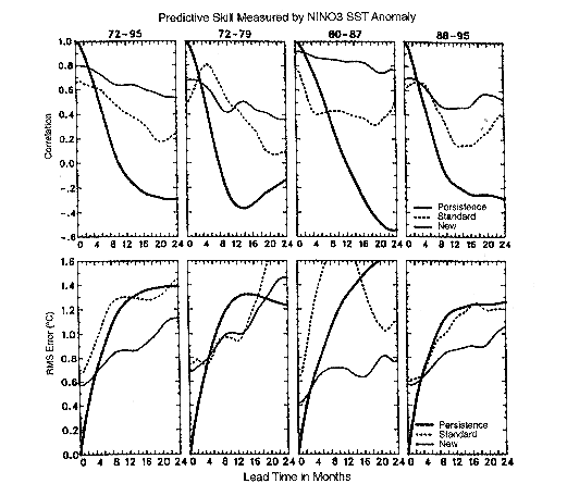
Figure 2-2.
Measures of skill of prediction of the Cane-Zebiak model.
The upper diagrams represent correlations of the forecast and
observed
NINO3 temperature index (the averaged monthly temperature in a
region
bounded by 90°W to 150°W, 5°S to 5°N) for various
time periods.
The thick line gives the persistence correlation (the correlation
of the
initial value with values later in time) which can be considered
the skill of
a forecast that always predicts the value of the NINO3 index to be
the value
at the initial time. The dashed line gives the correlation skill
of the
model under the original initialization procedures and the thin
black line gives
the correlation skill under improved initialization procedures. The
lower
diagrams represent the root mean square error between the forecast
and
observed NINO3 index. The thick line is the rms error of the
persistence
forecast, with the dashed and thin black line as above. Source:
Chen et al. (1997).
Reprinted by permission of the American Meteorological
Society.
Page 29
rather than a one-time response, analogous to the adjustments people make as weather forecasts become shorter-term.
Problems and Prospects for Seasonal-to-Interannual Climate Prediction
The forecasts whose skill is summarized in Figure 2-2 were made with a relatively simple coupled atmosphere-ocean model that was constructed many years ago. More complex models are being developed (see the review by Delecluse et al., 1998), and it is likely that the models will improve significantly. Techniques for initialization are also improving as more sophisticated ocean models can better accept the observed data and can better represent the mix of processes that change temperature in the ocean. The current status of prediction of tropical SST has recently been reviewed in Latif et al. (1998). A bibliography of papers on seasonal-to-interannual prediction is maintained at http://www.atmos.washington.edu/tpop/pop.htm.
The dominant limitation of these forecasts for use around the world is the paucity of data available to initialize the coupled models, especially ocean data. Only in the tropical Pacific do we have a system built specifically for climate prediction. There are regions of the world in which an inadequacy of ocean data implies that relevant SST cannot be reliably predicted by numerical means. Pilot arrays of instruments have recently been deployed in both the tropical Atlantic and Indian Oceans with a view toward eventually removing this limitation.
The unusual warm phase of ENSO that occurred during 1997-1998 led to a new reexamination of models and predictions. This was not only one of the largest amplitude warm phases of the century, but also it was predicted well enough and with enough lead time for the forecasts to be used. A directory of how the forecasts were done and information on the impacts of this warm phase and the use of the forecasts is given in http://www.ogp.noaa.gov/enso.
Toward Usable Knowledge
A key to making climate prediction more socially useful is to develop links between those making the predictions and those who can benefit from them. The users need to know what kinds of predictions are made and what kinds may be possible in the future. The forecasters need to know which predictions are most useful and how they should be presented. In general, the forecaster needs to understand the system or sector to which the prediction is applied. The acquisition of the needed knowledge by both the forecasting and user communities must be consid-
Page 30
ered sequential and arises from the social and physical learning engendered by a series of forecasts (some correct and some incorrect) and the responses they provoke in the user community. This section discusses current and potential uses of ENSO forecasts and some possible new directions in making climate prediction more useful.
From Tropical Pacific SST to Other Quantities
In theory, because the coupled atmosphere and ocean have global extent, a model that predicts SST in the tropical Pacific should also predict SST and the concomitant atmospheric response (temperature, pressure, precipitation) everywhere on the globe. As data in the ocean become more abundant, as global coupled models become better, and as computers get faster, predictions will approach the theoretical limit of predictability. At present, however, data for the world ocean outside the tropical Pacific are inadequate to initialize seasonal-to-interannual predictions. Therefore, different practical strategies are used. Either a limited region of the atmosphere-ocean system that includes the tropical Pacific is used to predict SST or a global coarse resolution atmosphere-ocean model is used to initialize only the tropical Pacific part of the ocean and therefore to predict Pacific SST only.
In order to go from tropical Pacific SST to quantities of wider usefulness, especially air temperature and precipitation, an additional step is required. Given a prediction of tropical Pacific SST, a high-resolution atmospheric model is run using climatological SST (i.e., normal SSTs for that time of year) everywhere but in the tropical Pacific, where the predicted values are used instead. Such models make predictions from tropical Pacific SST to climate in many other parts of the world, as shown in Figure 2-1. The models directly predict tropical Pacific precipitation, atmospheric temperature, and surface winds. To forecast these quantities at higher latitudes, the model must be run for a month or so to predict averages of land temperature, precipitation and winds, and it must be run many times with differing initial atmospheric and oceanic conditions, all consistent with the imperfect specification of these initial conditions.
The resulting ensemble of forecasts provides a distribution of all the conditions that could occur given these imperfectly known initial conditions. The resulting forecast can then be converted into a probability distribution. For example, Figure 2-3 shows a seasonal forecast of precipitation over North America for the unusually warm phase of ENSO that occurred during the winter of 1997-1998, in which the southern tier of states was predicted to have 60 percent chance of above average rainfall (these forecasts are available at http://iri.ucsd.edu/forecast/net_asmt). This method of presenting the forecast is valuable in that it makes explicit
Page 31

Figure 2-3.
Assessment forecast for North America produced routinely
by the International Research Institute for Climate Prediction.
The three
numbers in each box represent forecast probabilities that the
predicted
precipitation is above normal by more than one standard deviation,
within
one standard deviation of normal, and more than one standard
below
normal, respectively. Source:
http://iri.ucsd.edu/forecast/net_asmt/
that, even though the ENSO phase is warm, and the southern states were expected to have above-normal precipitation (see Figure 2-1), the probability of below-average rainfall is 20 percent and of normal rainfall also 20 percent.
Uses of ENSO Nowcasts
Certain regions of the world experience characteristic climatic patterns during warm and cold phases of ENSO (i.e., when the water in the tropical Pacific is anomalously warm or cold). Since ENSO evolves slowly, it may be useful to simply know, say in the North temperate fall, that ENSO is entering a warm phase. The physics of ENSO is known well enough to know that the warm phase usually peaks in the North temperate winter. A nowcast that a warm phase of ENSO is evident in the fall therefore conveys information that can be acted on.
Page 32
For example, warm phases of ENSO in the Pacific Northwest of the United States are generally (but not always) characterized by anomalously warm and dry conditions. A nowcast of evolving warm conditions in the tropical Pacific implies a number of conditions to be expected regionally, such as less snowpack in the mountains and earlier peaking and overall decreased streamflow in the major river systems fed by mountain snowpack. Since large parts of the Pacific Northwest depend on streamflow for irrigation, hydroelectric power, river transport, and city reservoirs, actions can be taken in advance to mitigate the effects of reduced streamflow.
Specific ENSO Forecast Needs—Time and Space Resolution
Forecast needs depend on the sector that may use the forecast and on the particular use within the sector to which the forecast is applied. Many users desire precipitation forecasts, averaged over the weather time scales—this usually means monthly averaged precipitation predicted a season to a year in advance. Such forecasts are useful for agriculture, sanitation and sewer management, hydroelectric power generation, river transportation, flood control, forest fire control, and mosquito control. Some users desire monthly averaged temperature forecasts for a season to a year in advance. Such forecasts are useful for coastal fishery management, fuel distribution and storage planning, construction involving concrete pouring, and the tourism, recreation, and retail sales industries. Climate scientists believe there are fewer practical applications of forecasts of other physical quantities (we regard the winds that go with hurricanes as part of hurricane prediction rather than wind prediction). The match between forecast information and its users' needs is discussed further in Chapter 4.
Applications that require averaged precipitation or temperature can benefit from ENSO forecasts, but applications that require information on when forecast events will occur cannot benefit, because of limitations in forecasting capability. Agriculture in India, for example, depends on planting relatively soon before the onset of the summer monsoon rains. Planting too soon means the seeds will die in the ground, whereas waiting too long to plant means that the ground may be too soft or muddy for planting. ENSO climate models may forecast the intensity of the monsoon rainfall in advance, but they cannot (and probably will never be able to) forecast the specific date of onset of the monsoon rains, because such onsets depend strongly on the details of weather patterns that are essentially unpredictable more than a week or so in advance.
In general, forecasts of averaged precipitation and temperature are made on the same spatial scale as the atmospheric model that is directly
Page 33
coupled to the ocean model that forecasts tropical Pacific SST or on the scale of the model used afterward to forecast from the SST forecast to the global effects of ENSO. This level of spatial resolution (on the order of 400km) is adequate for some practical purposes, but in regions with significant variations in elevation or terrain, a more finely grained regional forecast is often needed. For example, in the U.S. Pacific Northwest, weather systems come from the Pacific over the Olympic mountains leaving large rain shadows on the eastern slopes—locations no more than 50km apart can have annually averaged precipitation differing by a factor of five. Since precipitation is generally specific to spatial patterns of elevation and since many applications require specific locations for rainfall (e.g., rain falling on opposite sides of a mountain divide will fall in different catchment basins and therefore raise different reservoirs), these applications require finer spatial resolution. To make the forecasts useful for these purposes will require the use of finer-grained atmospheric models. This approach is under considerable development (Giorgi and Mearns, 1991) and these so-called mesoscale atmospheric models promise to be the tool of choice in downscaling seasonal-to-interannual forecasts.
Mesoscale models are also useful for examining the evolution of predicted extreme events. In some regions of the United States, the most important type of forecast is that of severe storms (e.g., tornadoes and hailstorms in the Great Plains in summer, hurricanes on the Atlantic and Gulf coasts in fall). Although no climate forecast scheme can predict a specific storm even a season in advance, mesoscale models embedded in larger-scale climate prediction models can indicate that the conditions under which storms form may be present and give some indications of where they might form and of their likely frequency.
Using ENSO Forecasts
ENSO forecasts have been used most where their skill is highest and weather variations are relatively small. In Peru, Ecuador, Australia, and the Pacific Islands, precipitation and temperature are tightly tied to the variations of tropical Pacific SST connected with ENSO, and the skill of predicting SST variations is relatively high (Figure 2-2). It is not surprising that these forecasts are used extensively. In the United States, however, the skill of the forecasts is lower and the variability in the phenomena to be predicted is higher. At least before the 1997-1998 ENSO events, the forecasts were not uniformly used in the sectors affected by seasonal-to-interannual climate variability.
An industry that has used the forecasts is California squid fishing. A forecast of warm water in the tropical Pacific implies warm water off the coast of California and therefore also implies declines in the squid catch.
Page 34
Fishing companies sign contracts to deliver squid at a given price at some time in the future. When the catch declines, the contracts must be honored with squid bought at prices that may be much higher. With a forecast of warm water, options are bought at current (more reasonable) prices to hedge the possibility of a bad catch (Glantz, 1996). In contrast, managers of U.S. water resources did not use ENSO forecasts much through 1996. In their judgment, the forecasts were neither skillful enough (although few managers know their skill) nor obviously useful in the absence of demonstrations of their effectiveness (Pulwarty and Redmond, 1997). The reasons that some decision makers act on the forecasts and others do not are a potential topic for research. We not that an important issue in the use of forecasts is that users have an appropriate understanding of the level of predictability they offer for local conditions.
Possible New Directions in Climate Forecasting
Non-ENSO Bases for Seasonal-to-Interannual Forecasts
ENSO is not the only signal of interannual climate variation. For example, although rainy season (February to April) precipitation in northeast Brazil is negatively correlated with SST in the tropical Pacific, it is more strongly positively correlated with SST in the subtropical South Atlantic and negatively correlated with SST in the subtropical North Atlantic (Uvo et al., 1998). On longer time scales, SST in the North and South Atlantic varies out of phase and affects rainfall in the Sahel. Forecasts of precipitation in northeast Brazil have been made with statistical models (Hastenrath and Greischar, 1993) and with models that assume persistence of Atlantic SST (Graham, 1994). Recently, there have been indications that the tropical Atlantic SST may be predictable (Chang et al., 1998). Skill at predicting SST in this ocean region will have applications in northeast Brazil and elsewhere.
ENSO has also been recognized to interact with a decadal signal in the tropical Pacific that couples strongly to decadal variations of SST in the North Pacific (Zhang et al., 1997). The North Pacific manifestation of this decadal signal has definite effects on the climate of the northwestern part of North America, in particular for the salmon fisheries (Mantua et al., 1997). Similar seasonal-to-interannual and decadal variability exists in a phenomenon called the North Atlantic Oscillation (Hurrell and van Loon, 1997), which correlates strongly with climatic conditions over Europe and the Siberian subcontinents. Neither the Pacific Decadal Oscillation nor the North Atlantic Oscillation has yet been shown to be predictable.
Page 35
The Potential to Develop Leading Climate Indicators
Interest has grown recently in the construction and use of climate indices that foreshadow or lead certain classes of human impacts. Such indices borrow from the tradition of indices of leading economic indicators that have been in use for several decades by the U.S. National Bureau of Economic Research (Easterling and Kates, 1995). They are not predictions, but rather historical integrations of climate data with embedded trends that may lead to increased vulnerability to impacts. Karl et al. (1995) developed and disseminated two climate change-related indices known as the ''climate extremes index'' and the "index of greenhouse climate response." Easterling and Kates (1995) proposed, but did not test, a number of potential indices that may lead impacts of seasonal-to-interannual climate variability. Among them are a hazard warning index, which would integrate such hazard precursors as depth of snowpack in advance of flood events, and an index of ecosystem health, which would integrate long-term climate precursors of species distribution, such as the climatic determinants of the Holdridge Life Ozone Classification. Considerable testing of such indices is needed before it can be determined if they provide useful knowledge. Leading climate indicators, if validated, could become essential components of early warning systems for famine, disease outbreaks, drought, increased flood potential, and other events of practical interest to individuals, firms, and disaster preparedness agencies.
Processes for Identifying Usable Knowledge
Until now, research decisions on how to improve seasonal-to-interannual climate prediction have been made entirely by the community of climate scientists. Great advances in understanding and predictive skill have been achieved that may have substantial social benefit. Nevertheless, the usefulness of the predictions has been largely a by-product of scientific progress rather than of an interaction between scientists and those who may use scientific findings, aimed at matching scientific capabilities and social needs.
As climate prediction moves from a purely scientific exercise to an enterprise justified to a greater degree by its social utility, both potentials for conflict and opportunities for collaboration arise. Conflict can arise when science that is promoted as decision-relevant is not seen as such by the participants in the affected decisions. Past experience with major scientific efforts at risk assessment indicates that scientific activities that are intended to be relevant to practical decision making are more effective and useful when they are designed in a process that integrates the needs
Page 36
and perspectives of those who would use the scientific results with the judgment of scientific specialists (National Research Council, 1996b).
It may be possible to bring considerations of usefulness alongside those of science in making future research decisions, so that future development of predictive skill will move in useful directions to the extent scientifically possible. For example, although there are many climate statistics that are potentially predictable, scientists have concentrated on only a few, such as average monthly temperature and precipitation. For some purposes, other climate statistics, such as average daily minimum temperature or the frequency of 24-hour periods with precipitation greater than 60mm may be particularly useful, so that efforts to develop and improve predictions of those quantities may have great social value.
Until now, there has been no process to try to identify such needs and consider whether they can be accommodated by scientific analysis. An important new direction might be in developing a process that tries more systematically than in the past to find matches between potential new scientific developments in climate prediction and the informational needs of users.
Two strategies might be used to bring scientific output and users' needs closer together. One relies on developing quantitative models of the sensitivity of the outcomes of weather-sensitive human activities to climate variation and using these models to identify the climatic parameters to which particular sectors or groups are highly sensitive or vulnerable. Chapter 5 reviews the current state of this sort of modeling. Information on climate sensitivity could be relayed to climate scientists as input to their decisions about which climate parameters to estimate. Another strategy relies on direct communication between the producers and consumers of climate forecast information, in which consumers discuss and identify the information they would find useful and the producers discuss the information they could provide. Chapter 4 discusses evidence pointing to the likely value of this participatory approach.
Findings
Recent scientific advances have resulted in unprecedented levels of skill in predicting climate—averages of such variables as temperature and precipitation—months to a year or more in the future. Forecast skill is continuing to improve. With respect to the usefulness of such climate forecasts to human decision makers, the following conclusions are justified:
|
Page 37
|


