
2
Science and Technology
The products and services provided by the NWS are based on scientific understanding of atmospheric, hydrologic, and related phenomena. The NWS employs a diverse array of technologies to observe these phenomena, assimilate the data obtained from the observations into analytical and predictive tools, and apply the results in describing the present state of the atmosphere and predicting future weather. This chapter describes anticipated advances in science and technology between now and 2025. These advances will be the basis for improving forecasts of weather, climate, and related environmental conditions. For the NWS to increase the utility of environmental information, it will need more accurate and more precise predictions, based on higher resolution computer models that incorporate better observations and more accurate representations of the underlying physical processes.
Observational Science and Technology
Measurement Capabilities and Requirements
Meteorology depends on observations of many variables that jointly specify the state of the atmosphere, including measurements of winds, temperatures, atmospheric pressure, and humidity for NWP models. Together with observations of cloud types and amounts and precipitation types and intensities, they describe present weather. On longer time scales, climate is defined by these same quantities along with precipitation, land surface temperature, albedo, vegetation, soil moisture, ocean surface temperatures, and atmospheric constituents, such as trace chemical species and aerosols.
This section describes many important recent developments, and some that the panel anticipates will occur by 2025, in the observing instruments and systems that enable current hydrometeorological situations to be specified and future events predicted on all spatial and temporal scales. Representative examples are given of science and technology that could significantly affect NWS operations.
For example, current observing protocols rely heavily on synoptic (synchronous and globally distributed) rawinsonde observations to provide three-dimensional, synoptic-scale depictions of basic atmospheric quantities. It is possible that, before 2025, the rawinsonde observations will be replaced by measurements from ground-based and satellite-borne remote sensors, together with in-situ measurements from sensors on board cooperating commercial aircraft and autonomously piloted vehicles. In geographically remote regions, particularly over the oceans, sensors on aircraft may be augmented by dropsondes. Constellations of small satellites may complement or replace single large polar orbiters, and interesting concepts have been proposed for both larger and smaller geostationary platforms. Meanwhile, continuing strides in information technology will revolutionize communications, data processing, and computer modeling, thereby facilitating fundamental improvements throughout the observation, prediction, and warning system.
Although this section focuses on the atmosphere, atmospheric interactions with the oceans and the land are essential for accurate weather and climate predictions. The evolution of atmospheric phenomena depends on the state of the entire, coupled system of atmosphere, oceans, ice, and land, including the fundamental quantities needed to define that state at a given time. By contrast, some of the events most critical to human affairs in the near term-severe local storms and their consequences, such as tornadoes and low level wind shear—are extremely localized in space and time. They require extremely detailed observations for analysis and prediction in near real time. To continue improving predictions of these storms, hazard detection and warning systems will require remote and in-situ sensing instruments.
|
BOX 2-1 Forecast Accuracy and Skill Many elements of a forecast contribute to the overall perception of its accuracy. Meteorologists refer to an objectively measurable element (or sometimes a combination of elements) of a forecast as a skill. Thus, forecasts can be compared quantitatively on the basis of their skill scores or measures of skill. A set of skill scores may be used to approximate the overall or general accuracy of a forecast. Throughout this report, the term "skill" refers to a defined, quantifiable element of a forecast that contributes to its accuracy. The term "accuracy" refers to the general or unspecified predictive value of a forecast or forecasting method. |
Since World War II, a remarkable transformation has occurred in meteorological, hydrologic, and oceanographic observations. Some of the most dramatic changes have been the creation and rapid improvement of meteorological and oceanographic satellites, as well as the development of a wide variety of observing methods based on radars and lidars (Serafin and Wilson, in press). These systems enable one to view (in the sense of collecting the definitive data about) the entire structure of all kinds of storms, from large extratropical cyclones to tornadoes. The internal properties and motions of these storms can be measured, as well as the characteristics of the environment with which they interact. In parallel with these successes, major advances have occurred in the observing tools for more conventional meteorological quantities, ranging from sensors for measuring temperature, atmospheric pressure, and humidity to lightning detectors.
Some advances have been made in the sensors themselves; others have been in the platforms or the communications systems. For example, the rawinsonde has been greatly improved, and winds can now be measured with the use of sondes equipped with GPS receivers, enabling more accurate tracking of the sonde. High-flying aircraft have dropped GPS dropsondes into hurricanes to provide soundings for incorporation into NWP models. These dropsonde soundings noticeably increased the skill scores (see Box 2-1) for forecasts of hurricane motion and landfall, with concomitant reductions in deaths and in costs of hurricane evacuation and protection of property (Burpee et al., 1996; Aberson and Franklin, in press).
Many advances in measurement technology have come from fields outside the atmospheric and hydrologic sciences. The miniaturization of electronics, the digitization of communication systems, advances in computational capabilities, and the mass production of high resolution color monitors to display graphics and text have all improved observing systems and added to their value in the forecast process. The transfer of technology from other fields will continue, and a keen awareness of developments in supporting technologies can lead to early benefits for NWS operations.
Doppler radar observations have provided great insight into the structure and motion of hurricanes (Marks et al., 1992; Gamache et al., 1993). Ground-based Doppler radars, often with automated algorithms (Serafin et al., in press; Serafin and Wilson, in press), routinely provide measurements for warnings of severe weather, including tornadoes and hazardous wind shears near airports. Despite these advances, however, a perfect tornado detection and warning system has not yet been developed for two reasons. First, not enough is known about the processes by which tornadoes form and dissipate or about their localized effects. Second, the observing and communication systems for alerting the public are still inadequate.
The tornado detection and warning issue highlights the problem of detecting or forecasting small-scale phenomena of all kinds: detection and forecasting depend on observations at scales comparable to those of the phenomena. Partly as a result of the NWS modernization, but also because of regular improvements in observing systems, the temporal and spatial coverage and resolution of observations has continued to improve. For example, in just one decade, from 1985 to 1995, the number of measurements made in one state (Kansas) increased by a factor of 30 (MacDonald, 1995). This change illustrates a general trend throughout the United States and in much of the developed world toward dramatic increases in the spatial and temporal density of observations.
The combination of improved observational tools, computers, and numerical models has led to substantial improvements in the accuracy of forecasts, extended the lead times of forecasts, and enabled more accurate localizations of storm forecasts and warnings (Polger et al., 1994). Recent improvements in global analyses have also produced higher quality data describing the global climate.
Soil moisture is an important factor in the surface fluxes of water and energy between land and air at a range of spatial and temporal scales. Subsurface moisture, which fluctuates more gradually than the precipitation rate, persists on seasonal to interannual time scales. Because soil moisture can be cumulative (in modeling terms, an integrated state), errors
in NWP can lead to incorrect partitioning of surface water between land and atmosphere and of energy fluxes between sensible and latent heat. Accurate observations of soil moisture at the spatial resolutions needed for NWP models could therefore substantially improve the overall accuracy of the models (Houser et al., in press).
An accurate observational base for soil moisture is also essential for realizing the benefits of distributed hydrologic modeling (see Advanced Forecasting Techniques later in this chapter). For example, because the time constants for significant rate-controlled processes are longer than for precipitation rates, the soil water and groundwater components of the terrestrial hydrosphere create considerable lag times in the overall response time of a regional climatic or hydrologic system to abnormal weather events (such as marked fluctuations in precipitation or solar radiation). A distributed hydrologic model that includes an improved characterization of these components and accurate initializing observations could assess the longer-term response of a regional system to anomalous events.
The future network of observations will rely much less on synchronous global rawinsonde measurements. Modelers are developing methods of assimilating asynchronous and opportunistic measurements (see Data Assimilation later in this chapter). It will soon be possible to accommodate data from rawinsondes or dropsondes released at times and places selected by field office staff as being most useful for local forecasting.
Moreover, many observations will be available through partnerships between government and the private sector, such as measurements from commercial aircraft obtained through the Aircraft Communications Addressing and Reporting System (ACARS).1 The federal government, states, county, and local governments, and segments of the private sector will all become rich new sources of data. For example, a state-operated network of surface meteorological instruments already in place in Oklahoma provides the basis for a broad spectrum of applications, including reports on road conditions and air pollution, as well as severe storm warnings (Brock et al., 1995).
Improved observations—more closely spaced in distance or time or made with more accurate instruments—will generally yield better four-dimensional analyses and lead to improved forecasts and warnings. Degraded observations may be less expensive, but they also degrade the quality of products and services. The trade-offs between changes in the value of products and services and changes in the costs of providing data must be frequently reevaluated because the benefits and costs are likely to change with time. Although the value of data and information is difficult to quantify, mechanisms such as the North American Atmospheric Observing System Program2 could be used to assess trade-offs on a regular basis (McPherson, 1996; Shumbera, 1997).
Surface Observations
The core of the nation's current surface observing network consists of approximately 1,000 stations equipped with an Automated Surface Observing System (ASOS). These stations are supplemented by several thousand stations in the Cooperative Observer Network, which could be upgraded to provide automated measuring and reporting. Together with the various state-operated (e.g., Brock et al., 1995) and other special-function networks, these sites would form a network of about 10,000 stations. The ASOS and Cooperative Observer Network stations already provide the observational basis for the national climate database.
Incremental improvements in reliability or accuracy of surface observations may occur, as well as reductions in cost. Significant advances are likely in the capability of microprocessors to process measurements of the meteorological, hydrological, and other physical quantities in varied and flexible formats. Microprocessors can calculate derived statistical measures, such as the maximum, minimum, average, and standard deviation of selected phenomena over a standard time interval, as well as rates of change and other derived indicators. Microprocessors can also facilitate the transmission of observational data for incorporation into the NWS database. Improvements in automated sensing of present weather (e.g., clouds and precipitation) are also likely.
The Cooperative Observer Network provides the basic data for defining the climate of the United States and for monitoring climate change. Reports from this network also provide important information for mesoscale flood forecasting (NRC, 1998a). Greatly expanding the size of the Cooperative Observer Network and the timeliness of its data would improve mesoscale weather forecasts. Even with current technology at 1998 prices, homes or offices could be equipped with inexpensive, accurate, automated atmospheric observing systems that could transmit data to the NWS and national climate database on standard meteorological quantities (temperature, atmospheric pressure, water vapor pressure, winds, and precipitation) and even chemical constituents (e.g., ozone, ozone precursors, sulfur dioxide, and carbon monoxide). If a hundred thousand U.S. homes and offices had these systems with adequate siting, calibration, and maintenance, they would create a very dense nationwide network of meteorological and chemical surface observations, with average spacing of about 10 km.
The panel anticipates major developments in special purpose, surface observing networks operated by public or private-sector entities. The Oklahoma Mesonet, which has already been mentioned, is one example. Many state highway departments operate observing networks to facilitate traffic flow and road-clearing operations. Airports, urban centers, and power generation facilities also operate special networks. As the value of specific weather and environmental data increases, the number and variety of these networks will also increase (see Chapter 3 for a discussion of the expanding role of non-NWS observing systems).
For surface observations on the oceans, drifting and moored buoys and ships of opportunity could carry instruments to observe the standard quantities. Underwater instrument systems on these platforms could use thermistor strings and radio positioning techniques to measure ocean temperature, salinity, and current velocity at several levels, down to several kilometers below the surface. To determine winds with great accuracy and high resolution for any location on the ocean, surface wind observations from these stations (or surface wind data from satellite scatterometer sensors) could be combined with high-resolution predictions of boundary layers from improved global weather prediction models.
In the future, other "platforms of opportunity" may prove similarly useful for increasing the density of surface (and in some cases upper-air or ocean subsurface) observations. Platforms might be ships, trains, buses, fleets of taxicabs or trucks, emergency response vehicles, and perhaps even personal vehicles.
Atmospheric Observations above the Surface
Data on the four-dimensional structure of atmospheric pressure, temperature, humidity, and winds from the surface to the lower stratosphere are the foundation of NWP models. Currently, the rawinsonde network is the backbone of the system for atmospheric observations above the surface (upper-air observations), although satellite-borne and surface-based remote sensors are becoming increasingly important. The rawinsonde network provides limited spatial and temporal samples, and rising costs could reduce the frequency of rawinsonde observations. In fact, surface-based remote sensors can provide better temporal continuity, and satellite-borne sensors can provide essentially contiguous spatial coverage.
The panel anticipates major improvements in surface-based remote sensors for upper-air observations. Current technologies include Doppler radars, such as the WSR-88D (commonly called NEXRAD) and wind profilers (see the section on Radar Systems below for details), microwave radiometers, acoustic sounders, and various lidar (light-wavelength radar) systems. These technologies provide profiles or path-integrated values of humidity, temperature, and wind, as well as quantitative measures of other weather variables, such as cloud liquid water. New concepts for inferring path-integrated moisture using existing Doppler radars may prove to be operationally feasible (e.g., Fabry et al., 1997).
Ground-based GPS receivers that view several GPS satellites at once can generate temporally continuous profiles of integrated water vapor content along each slant path from the ground station to a GPS satellite in view (Ware et al., 1997). Tomographic inversion techniques applied to these profiles can be used to construct accurate and complete three-dimensional water vapor fields for the atmosphere within 100 km (horizontal distance) of the station. Ground-based horizontally and vertically scanning Doppler radar wind profilers at these stations could provide continuous vertical profiles of the three-dimensional wind for the same atmospheric volume.
Airborne Systems
Observing systems carried on aircraft can provide both in-situ (immediate vicinity of the sensor) measurements and remote sensing. Thus they can be used for both upper-air (in situ) and surface (remote sensing) applications. In addition, dropsondes can be released from aircraft at precise locations.
In-situ observations of wind and temperature, which are made routinely as part of an aircraft's flight information, are now being transmitted in real time from many commercial aircraft via ACARS. The data are sent from ARINC to the various air carrier dispatch centers for aviation use and to NOAA' s Forecast Systems Laboratory and NCEP for use by the meteorological community.
More than a dozen major air carriers and delivery service companies operating out of the United States and Canada participate in the ACARS program. Approximately 10,000 reports of winds and temperatures are made each day, and this number is expected to increase. Although more than 90 percent of the data from these reports are at cruise levels (near 9 km), Benjamin et al. (1991) have shown that using these upper-air observations in NWP models has improved wind and temperature predictions. ACARS coverage over North America is almost complete, and the system is expanding. Other countries are developing or have developed similar communication systems.
If water-vapor observations could be added to the ACARS data stream, an exact pressure-height relationship could be computed from observations taken during ascents and descents. This approach would provide data equivalent to radiosonde observations. Better definition of water vapor fields would also lead to better forecasts of precipitation. A multiyear demonstration program is now under way to confirm that water vapor can be measured from commercial aircraft conveniently and accurately. If the demonstration program is successful, next-generation water vapor sensor systems are likely to be installed on a substantial portion of the domestic air carrier fleet.
The future ACARS program may include greater numbers of commercial aircraft, global coverage, an ACARS-
type package for general aviation, and sensors to measure atmospheric turbulence and trace chemicals. Dropsondes may also be released from commercial aircraft in selected areas to provide vertical profiles of key weather elements. Downward-looking remote sensors that can measure soil moisture or snow pack water content from commercial aircraft may also become practical. They will become more important as the capabilities evolve for modeling coupled atmosphere-surface processes.
Radar Systems
Ground-based and airborne Doppler radars provide a wide range of observations. These systems include the Next Generation Weather Radar (NEXRAD) systems and wind profilers, which have demonstrated their ability to detect localized phenomena, such as downbursts near airports and mesoscale cyclonic rotations, which are precursors to the development of tornadoes. The more routine observations of the vertical profile of horizontal wind and its changes with time have also proven to be of great value for forecasting, particularly for aviation forecasts and NWP models.
Measurements of precipitation by properly calibrated radar have many hydrometeorological purposes. Although many of the existing algorithms for measuring rainfall by radar can be improved, present methods already provide values for areal accumulations that could otherwise be provided only by expensive, dense networks of gauges (networks this dense are available at only a few experimental sites). Promising methods have been developed for a wide spectrum of Doppler radar applications, ranging from the nowcasting3 of flash floods to mainstem hydrologic predictions and even calculations of monthly, wide-area, accumulated precipitation for monitoring climate.
One of the candidate modifications proposed for NEXRAD radar is polarimetry (Bringi and Hendry, 1990), a technique that uses the differential reflectivity between two signals polarized at right angles to measure the mass-weighted mean size of drops of precipitation. Other polarimetric variables can also be measured to infer other characteristics of the precipitation. Polarization techniques can provide more accurate precipitation rates than can be measured by a singly polarized radar beam. Differential echoes and related parameters can be used to distinguish between rain, hail, and snow, as well as to distinguish precipitation from other reflectors, such as airplanes, birds, and insects.
A very different technological approach to improving radar measurements of rainfall is based on novel quasi-statistical methods. Some of these techniques use the physical properties of radar echoes to classify precipitation by type and then, based on prior observations of that precipitation type, select an appropriate rain algorithm from a computer library of algorithms (Rosenfeld et al., 1995). Technological and statistical approaches may even be combined to yield more accurate estimates of precipitation. Improvements in measuring snowfall accumulations by conventional Doppler radar are also being studied (Super and Holroyd, 1997; Xiao et al., 1998).
Present-day NEXRADs are the basic tools for detecting severe thunderstorms and mesoscale vortices, the precursors of tornadoes. Some tornadoes are so small and short-lived that they are missed by the NEXRAD detection algorithm. But the majority of severe tornadic storms are detected, and warnings are issued with sufficient lead time to save lives and reduce injuries (Polger et al., 1994; Bieringer and Ray, 1995). In the future, it will be possible to equip emergency response vehicles and aircraft with simple Doppler radars. These mobile radars will be able to get closer to suspicious storms than a fixed-site radar can. The higher resolution of the velocity structure would make these observations more reliable and increase confidence in the tornado warning system. This concept has already been demonstrated with advanced experimental airborne Doppler radar (Hildebrand et al., 1995) and with truck-borne "Doppler on wheels" (Wurman et al., 1997).
NEXRAD is but one of a number of current weather and aviation Doppler radars. Others include wind profilers that are used to measure winds up to the tropopause, the Terminal Doppler Weather Radar for detecting microbursts and low-level wind shears in airport terminal areas, and the airport surveillance radar (ASR-9) for both air traffic control and limited weather surveillance. Various research radars are being used for Doppler observations, polarimetric measurements of precipitation, and cloud detection—the latter typically at very high frequencies of 35 to 94 GHz. Many television stations also operate their own Doppler weather radars.
An imaginative recent development is a multistatic Doppler radar (Wurman et al., 1995), which uses a basic radar, such as NEXRAD in normal operation, plus associated low-cost, wide-beamwidth passive receivers at nearby locations. As the basic radar scans, each receiver receives the echoes from a different perspective and measures a different component of the wind. The combination of two or more measurements gives the full wind vector, which is an important aspect of localized convective storms, which have highly variable winds. A single Doppler radar receiver can measure only the radial component of the wind velocity.
Doppler radars have not yet been exploited to their full potential. Methods are being investigated to determine the full wind vector with a single radar (Wilson and Megenhardt, 1997). The resulting wind fields could be used to reconstruct the temperature and pressure fields that drive the motion of the air. These derived fields could then be assimilated into storm-scale numerical models to predict the evolution of storms (Sun and Crook, 1998). These and other advances in
the numerical modeling of convective storms (e.g., Kopp and Orville, 1994) promise real-time predictions of storm behavior on scales as small as 100 m and time intervals of a few minutes. The anticipated tremendous increases in speed and computational capacity of computers will make it possible to model the microphysics (particle types, phases, and size distributions) and dynamics of storms with unprecedented detail and accuracy in real time.
An important question is whether a multipurpose radar can be designed to provide most, if not all, of these diverse weather observations, as well as non-weather-related functions (see Box 2-2). Putting aside issues of particular site locations and operational control, a multipurpose radar of this kind is certainly feasible. For example, a system might radiate at three wavelengths (e.g., 3, 10, and 70 cm) at high power from a five-sided phased array (facing in the four ordinal directions and vertically), obviating the need for mechanical scanning. High transmitted power, a high-gain antenna, and sensitive receivers would ensure the detection of clouds and clear air echoes. Pulse compression would provide a sufficient number of independent signal samples to obtain rapid, accurate measurements of reflectivity and velocity of the entire hemisphere overhead in less than a minute. A combination of polarimetry and wavelength dependence could distinguish rain, snow, and hail from one another and from aircraft, birds, and insects. Lightning detection would also be possible with the rapid scan. This system could be used simultaneously for aircraft tracking and control and taking observations of weather-related phenomena. Although this radar is still visionary, studies of less ambitious radars are already in progress (OFCM, 1997). However, considerable research, development, and testing will be needed in order for advanced multipurpose radars to become operational.
Satellite-Based Observing Systems
In 1960, well before the dramatic views of storm systems provided by Doppler radar were available, the public and the meteorological community were enthralled by the images provided by TIROS (television and infrared observation satellite), the first U.S. weather satellite. In contrast to those pioneering, qualitative weather pictures, satellites now provide magnificent color-enhanced images spanning the globe. Satellites also provide a broad range of quantitative measurements that are used routinely in preparing forecasts and severe storm warnings and are assimilated into NWP models. Time-lapse sequences of the whirling clouds of hurricanes are familiar to virtually every U.S. household. Current satellites are operated by the National Environmental Satellite, Data, and Information Service (NESDIS) and its counterparts elsewhere in the world.
Along with the NESDIS programs, a wide range of Earth observing systems deployed by the National Aeronautics and Space Administration (NASA) have important applications for operational meteorology and hydrology. Data from these spacecraft also enable the analysis and modeling of broad environmental phenomena and systems, of which weather and climate are components. Even the GPS satellites, which were intended for positioning and navigation, have important emerging uses in observing fundamental weather variables. To cover this wealth of satellite-based technologies, this section is divided into four categories of current and future systems: (1) geostationary and polar-orbiting satellites like those currently operated by NESDIS, (2) satellite-based radar systems, exemplified by the new tropical rainfall measuring mission (TRMM) satellite, (3) GPS (or similar positioning constellations) for occultation measurements, and (4) the NASA Earth observing system (EOS) and its potential future extensions.
Geostationary Operational Environmental Satellites and the National Polar-Orbiting Operational Environmental Satellite System
Only a combination of geostationary and polar-orbiting satellites can provide the spatial and temporal coverage required to measure the atmosphere and Earth system for weather and climate. Geostationary satellites provide images at high horizontal and temporal resolution, of clouds and total water vapor in tropical and middle latitudes but not over polar regions. Although some progress has been made in deriving vertical soundings of temperature and water vapor from geostationary satellites using infrared and
|
BOX 2-2 Beyond NEXRAD NEXRAD, known also by its technical designation WSR-88D, may be the last radar system deployed operationally and dedicated to weather surveillance. Radars require large segments of valuable electromagnetic spectrum bandwidth, and they cannot provide uniform coverage, even over land. To conserve spectrum bandwidth for other purposes, multi-function radars serving varied users, meteorology among them, may become mandatory in the future. |
microwave channels, the soundings have relatively low vertical resolution. Polar orbiters provide observations for all latitudes and longitudes, including polar regions, several times a day, and radiometric temperature and water vapor soundings derived from polar orbiters have better vertical resolution than the soundings from geostationary satellites. However, the vertical resolution of radiometrically derived soundings from both geostationary and polar-orbiting satellites is not high enough for accurate initialization of NWP models.
Current soundings do not adequately resolve important structures in the atmosphere, such as the tropopause and upper-level fronts. They are also generally limited to clear or partially clear regions of the atmosphere and have to be calibrated on a regular basis. In contrast, soundings derived by the radio occultation technique on polar orbiters (discussed below) have lower horizontal but higher vertical resolution than radiometric soundings. Radio occultation soundings are not affected by clouds, precipitation, or aerosols and are self-calibrating. Thus, radiometric and radio occultation sounding methods are synergistic, as are geostationary and polar-orbiting satellites. A combined system would provide high resolution global coverage, spatially and temporally, of cloud images, temperatures, and water vapor.4
In a report on the continuity of spatial and temporal coverage by the weather satellites in the NESDIS program, the National Weather Service Modernization Committee evaluated NOAA's plans for continuing operations of the geostationary operational environmental satellite (GOES) program and the national polar-orbiting operational environmental satellite system (NPOESS) (NRC, 1997). These satellite systems will remain an integral part of NOAA's national and global observing systems and will constitute critical observational tools for NWS operations well into the twenty-first century. The linkage of NPOESS with European polar-orbiting satellites, called METOP, in the near future will be an important step toward the creation of an integrated global observing system comprising the geostationary and polar-orbiting satellites of many nations. If NOAA assigns appropriate priority to this program, an integrated system is likely to be operational before 2025.
Geostationary satellites are important for monitoring the tropics and middle latitudes, especially when near-continuous monitoring of the Earth's surface or atmosphere is necessary, in the case of rapidly evolving severe storms, for example. Progress continues to be made in the analysis, display, and uses of GOES data for a variety of research and operational applications. For example, the digital data from GOES that are now used in NCEP's numerical models include high-resolution observations of winds from time-lapse water vapor and cloud imagery. Work is under way to incorporate the three-layer precipitable water and clear-air radiances from the GOES sounders as well. Digital satellite information available at NWS field offices includes a product that specifies low-clouds derived from GOES imagers. Other products include an index of atmospheric stability and an indicator of the amount of precipitable water above a location derived from GOES imagers and sounders.
The most valuable products from GOES satellites are cloud and water vapor images. The highest NWS priority for improving these products is frequent, high-quality, full-disk imaging to support its forecast and warning operations. GOES satellites also provide some useful information on the horizontal and vertical distribution of temperature and water vapor, as well as some useful information on winds based on rapidly sequenced images of cloud and water vapor features. However, complementary low Earth orbit (LEO) satellites are needed to provide the most important observations for improving NWP model forecasts: wind observations from laser systems and temperature and water vapor soundings with higher vertical resolution and greater accuracy, which could be obtained with the radio occultation technique.
For the next decade, the NWS has set a goal of determining the value of real-time lightning mapping from geostationary orbit. Most cloud-to-cloud lightning can be observed from space at any time of the day. These observations of the development of vigorous storm and energy release typically provide valuable indicators of the onset of convective precipitation. The observations are particularly valuable in areas not covered by NEXRAD radars, such as the Gulf of Mexico and mountainous regions. The lightning mapper (LM) is now successfully operating on TRMM (see below). With adequate support, a version of LM designed to fly on a GOES could be built within two years.
In the past, data from NOAA's polar orbiters have been used mostly as quantitative input for numerical models, which are used primarily for longer-range weather and climate predictions. The data from geostationary satellites have been used mostly in a qualitative mode by local forecasters for issuing short-term forecasts and warnings of hazardous weather. With advances and improvements in NPOESS sounders, as well as in weather and climate forecasting, the use of NPOESS data by local and regional offices for computing specialized products, such as soil moisture, precipitable water, and winds, has greatly increased. Satellite constellations and clusters could provide significantly better coverage and open new approaches for calibration and data continuity (NRC, 1998c). Data from geostationary satellites are being used in numerical predictions and by local forecast offices for specialized products, such as stability indices and estimates of total precipitable water (potential rainfall). Thus, it is becoming increasingly apparent that GOES and polar-orbiting satellite data sets will have to be used as a "mix" of observations throughout the NWS, at both national centers and local forecast offices.
Full exploitation of the synergism between geostationary and polar-orbiting satellites will provide the full spatial and
temporal coverage for monitoring and predicting changes in the land-ocean-atmosphere system on both short (weather) and long (climate) time scales. Together these satellites can provide the data to address NWS's priorities for better forecasts and warnings, as well as the scientific priorities of NASA and NOAA.
Future generations of environmental satellites will benefit from a number of synergies: from a partnership among nations leading to a global observing system; from combinations of measurements from instruments on a single satellite or on multiple satellites; from advanced analytical systems that can combine satellite, radar, and other related in-situ observations to produce refined, accurate values for standard meteorological quantities; and from numerical models that can assimilate data and interact with the observing systems.
Satellite-Based Radar Observing Systems
The TRMM satellite, which was launched in November 1997, illustrates the coming of age of radar as a space-based environmental observing system. TRMM carries the first meteorological radar in space, along with a multichannel microwave imager, a visible and infrared (IR) radiometer, an Earth radiation budget sensor (the Clouds and Earth's Radiant Energy System [CERES]), and a lightning imaging sensor. The purpose of the TRMM is to estimate precipitation in the tropical regions of the world. TRMM observations can distinguish between convective and stratiform rainfall and are expected to provide mean vertical profiles of latent heating and evaporative cooling. When assimilated into models, this information is expected to improve both synoptic-scale and long-range forecasts. Future observations will enhance forecasts of weather phenomena, such as the El Niño Southern Oscillation.
GPS Radio Occultation Measurements
One attractive approach to atmospheric profiling is limb scanning of the atmosphere during the occultation of the signals from the GPS satellites as received by polar-orbiting LEO satellites (Melbourne et al., 1994). The measurements relate directly to the refractivity of the atmosphere and, therefore, to electron densities in the ionosphere and temperature and moisture in the stratosphere and troposphere. Results of the proof-of-concept GPS/MET (GPS/Meteorology) experiment demonstrated the high accuracy (1 K) and high vertical resolution (approximately 500 m) retrieval of temperature soundings in the upper stratosphere and the capability to derive water vapor profiles in the lower troposphere, given reasonably accurate independent temperature information (Kursinski et al., 1997; Rocken et al., 1997). The characteristics of GPS/MET observations complement the soundings derived from radiometric measurements by GOES and NPOESS satellites.
The Earth Observing System and Potential Extensions
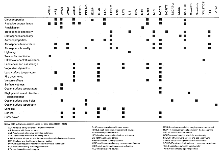
Additional satellite capabilities will be provided by NASA's EOS missions. Table 2-1 lists 24 measurements that will be made by EOS. Although these measurements are intended primarily for monitoring climate and global change, virtually all of them are directly or indirectly relevant to short-term and medium-term weather predictions. For example, greatly improved atmospheric temperature and humidity soundings, which will come from the advanced infrared sounder (AIRS), the advanced microwave sounding unit (AMSU), and the high-resolution dynamics limb sounder, could provide basic data for regional and synoptic weather predictions. AIRS alone is expected to provide radiative fluxes and profiles of temperature and moisture that are substantially more accurate than current measurements. It will also provide the mean boundary layer temperature and column water vapor up to about 1 km, both of which are important for forecasts of clouds, precipitation, and severe storms.
Versions of some of these instruments will also be aboard NOAA's operational environmental satellites. The NOAA K satellite in the polar-orbiting series (launched May 13, 1998) carries a version of AMSU with 15 channels near the 56-GHz oxygen band for temperature sounding and 4 channels near the 183-GHz water vapor band for humidity profiles. Present NPOESS plans call for the flight of a high resolution sounder with capabilities similar to the AIRS sounder on NOAA N', the polar-orbiting satellite that will follow L, M, and N, around 2010.
Combinations of instruments, such as AIRS and the moderate resolution imaging spectrometer, promise to provide accurate observations of surface skin temperature, which can be used to estimate sensible and latent heat fluxes over the ocean (in combination with simultaneous measurements of surface winds by a scatterometer). Heat fluxes are important forcing factors in the development of intense cyclonic storms. NPOESS plans to fly a conical microwave imager sounder about 2010, which will use both a high-resolution sounder and a multichannel microwave instrument to estimate ocean surface winds and determine ocean heat fluxes.
A variety of modeling experiments with both real and simulated data have shown the great value of accurate wind observations over the oceans. For example, the assimilation of data from a NASA ocean wind scatterometer (NSCAT) aboard Japan's advanced Earth observing satellite into general circulation models has significantly improved the skill scores of operational marine weather forecasts. Among other phenomena, these observations have detected fronts and extratropical cyclones that ordinarily might have gone undetected (Atlas et al., in press). NOAA intends to use the NSCAT data to monitor ocean-atmosphere phenomena, such as the El Niño Southern Oscillation and sea ice in the polar regions (NOAA, 1998).
One of the missing observational links has been an accurate and reliable measure of the winds throughout the entire
troposphere. Observing system simulation experiments have shown that a wind profiler with an assumed accuracy of 1-3 m/s RMS (root mean square) would improve forecasting skill more than any other proposed space-based measurement (Atlas, 1997). Several alternative techniques for making these measurements have been discussed (Abreu et al., 1992; Baker et al., 1995). A Doppler lidar wind measurement system called the space readiness coherent lidar experiment (SPARCLE), based on new solid-state laser technology, is scheduled for flight in 2002 on the space shuttle (NASA, 1998). If it performs successfully, a lidar wind profiler may be flown on the NPOESS generation of operational polar-orbiting satellites.
Other quantities that would be especially beneficial for weather prediction on a variety of scales are cloud properties, radiative energy fluxes, and precipitation. These quantities will be measured by AIRS, AMSU, CERES, the advanced spaceborne thermal emission and reflection radiometer (ASTER), and the stratospheric aerosol and gas experiment, among others. Measurements of snow cover and sea ice, which are expected from ASTER and the advanced microwave scanning radiometer, are related to surface albedo and heat transfer, two important quantities in NWP models. Estimates of snow pack properties, such as coverage and thermodynamic properties (e.g., temperature and equivalent water content) derived from satellite sensors using multispectral observations, could be developed further and integrated into hydrologic and regional atmospheric assimilation and forecasting systems.
Soil moisture is an important measurable quantity that is not currently included in EOS plans. However, a soil moisture mission is one of several satellite observing missions that have been proposed independently of EOS. Remote sensing of soil moisture—for example, by a synthetic aperture passive microwave sensor, as proposed for the HydroStar program (Cavalieri and St. Germain, 1995)offers the possibility of routine, gridded data that could be assimilated into soil moisture representations for better NWP models.
Because continuity in the NESDIS operational satellite program is essential for studies of climate and global change, the National Weather Service Modernization Committee recommended that climate research, such as research being conducted under EOS, be integrated with the NESDIS operational satellite programs (NRC, 1998b). Similarly, the research satellites operating under NASA's Earth Science Enterprise and the research satellites planned in the EOS program (NASA, 1995) offer a wide range of new and exciting measurements that will be beneficial for operational environmental predictions and warnings. Research satellites of the European Space Agency, such as the European Remote Sensing satellites ERS-1 and ERS-2, which are already in flight, the forthcoming environmental satellite ENVISAT, and the Canadian radar satellite RADARSAT could also provide useful data. The many opportunities for improving and expanding observations are indicators of the rapid evolution of the operational satellite system.
Numerical Modeling and Data Assimilation
Introduction and History
The foundations of quantitative modern NWP are the Newtonian laws of motion, the conservation of mass, the laws of classical thermodynamics, and the laws of electromagnetic radiation transfer and interactions with matter. Numerical approximations to these laws describe the atmosphere system, including the oceans, land, and ice surfaces, and are solved on computers as initial value problems. The scientific and mathematical basis for NWP, which will be even more important in 2025 than it is today, was predicted by Lewis Fry Richardson in Weather Prediction by Numerical Process, published in 1922. (The history and scientific basis of NWP are summarized in Tribbia and Anthes [1987]).
Over the years, model representations of the behavior of the real atmosphere have become more and more accurate (Kalnay et al., 1998). The first experimental NWP model was run in April 1950 for a region encompassing North America on a primitive computer called the ENIAC (electronic numerical integrator and calculator), which was far less powerful than today's hand-held calculators. This first model, which later became the first operational forecast model run at the National Meteorological Center (now NCEP), was based on a single conservation principle and equation and gave answers only at one mid-troposphere level. Current models describe the large-scale dynamics of the atmosphere, as well as physical processes, such as radiation, cloud formation, precipitation, energy dissipation, and interactions between the atmosphere and the surface of the Earth. They now cover many levels of the troposphere, giving a nearly complete picture of the atmosphere.
Observations and Analysis
Observations provide the basic information that NWP models require to make forecasts. An NWP model describes the temporal evolution of the atmosphere from an initial state. It requires knowledge of the value of each state-defining variable at that initial time. In the early years of numerical predictions, individual observations were "analyzed" by fairly simple mathematical techniques to derive the initial values of variables. The analysis process was based on subjective procedures, often involving human decisions and interventions, to eliminate "bad" observations. The principal purpose was to produce, from irregularly spaced weather observations, an array of values of atmospheric variables at model grid points. As part of the analysis process, data were often modified slightly to reflect certain assumed "balances" in the atmosphere; adjustment of the data is
referred to as "initialization." Analyses and initializations were, in general, produced twice each day, corresponding to the global rawinsonde observation times of 00 and 12 UTC. Changes in the methods of atmospheric data analysis are reviewed in Daley (1991).
Data Assimilation
In recent years, the analysis and forecast portions of the NWP process have become much more closely linked through the direct assimilation of data into models. Observations are used to "correct" or adjust model predictions wherever and whenever the observations are available. Some of the advantages of data assimilation over the older analysis process are (1) more effective ways of dealing with the asynchronous nature of the vast majority of new observations (such as those from aircraft and weather satellites), (2) the use of an observation of one or several model variables to modify and improve the values of all variables through physical adjustment processes, and (3) the use of the variable itself (e.g., radiances from satellites) rather than derived quantities (e.g., temperature profiles derived from observed radiances). This latter capability has only recently been developed operationally and has led to significant improvements in forecast skill (Eyre et al., 1993; Derber and Wu, 1998). Preliminary studies have shown that the assimilation of atmospheric refractivity (Zou et al., 1995) or radio wave bending angles (Zou et al., 1999) obtained through the radio occultation technique will cause the model variables to adjust toward the actual state of the atmosphere.
A powerful, though computationally expensive technique for data assimilation is the four-dimensional variational data assimilation, or 4DVAR (Lewis and Derber, 1985; Errico, 1997). With the 4DVAR process, observations over time for any model-predicted variable (or observations over time for a function of a model variable, such as radiances or refractivities) can be assimilated into the model. As these observations are assimilated, the model's physical adjustment processes allow the impact of the observations to be spread throughout the model. With this approach to assimilation, the system of model equations plus observations produces a better data analysis than could be obtained from the observations alone. This assimilation process is the basis for the retrospective "reanalysis" of past atmospheric data using modern models (Kalnay et al., 1996).
Predictability Limits
The atmosphere is a nonlinear fluid system and hence, as shown by chaos theory, has limited and variable predictability (Lorenz, 1963; Thompson, 1983). No matter how accurate the models or how precise the observations, the temporal limits to predictive skill (which are not yet known for all weather phenomena) cannot be exceeded. Small errors in initial conditions, errors generated by the numerical approximations to the model's differential equations, and errors introduced by imperfect physical approximations grow with time and ultimately limit the accuracy of forecasts.
Originally, low resolution and the difficulty of representing physical processes, such as radiation, latent heat release, and boundary layer processes, were the principal sources of errors in numerical forecasts. As models have improved in the past several decades, the situation has changed, and deficiencies in observations have become the major source of errors. As observations become more accurate and complete, and as models become more highly resolved, it seems likely that the dominant errors will again be produced by errors in the model's physical approximations.
The predictability of many atmospheric phenomena, especially mesoscale and smaller phenomena, are limited (although these limits have not been quantified). In general the largest scales of atmospheric motion, such as the long-wave patterns at the jet stream level, are more predictable than smaller scales of motion, such as those associated with thunderstorms. Thus, although jet stream patterns can be forecast routinely with some skill for a week or more, individual thunderstorms are usually predictable for only a few hours beyond the latest observation base.
Quantitative estimates of predictability generally refer to the predictability of medium and large-scale waves in the atmosphere (wavelengths of 1,000 to 40,000 km). Although these estimates have been made in a variety of ways (Thompson, 1984), the estimates are all similar. Errors, no matter how small, typically grow at a rate that causes forecasts to become inaccurate in the range of 10 to 20 days.
Although the atmosphere is predictable for only a few weeks, the coupled ocean-atmosphere system may be predictable for a year. For example, the Tropical Oceans Global Atmosphere Program of the World Climate Research Program has demonstrated that the El Niño phenomenon in the tropical Pacific Ocean and the associated Southern Oscillation are to some extent predictable a year in advance (Trenberth, 1997). Anomalies in the sea-surface temperature, which may persist for months, modify the precipitation distribution over the Pacific, and the modulated latent heating distribution affects the jet stream and associated weather patterns over regions of the atmosphere far from the source of the sea-surface temperature anomaly. Coupled ocean-atmosphere models have been able to predict these shifts in global weather patterns, and it is likely that further improvements in models and initial data will lead to significantly better climate predictions in the next several decades. Trenberth (1997) reviews the scientific basis for interannual predictions based on long time scales associated with atmosphere-ocean interactions and recent progress in the development of operational climate forecast models.
Forecasting Skill
History has shown that new operational forecast models
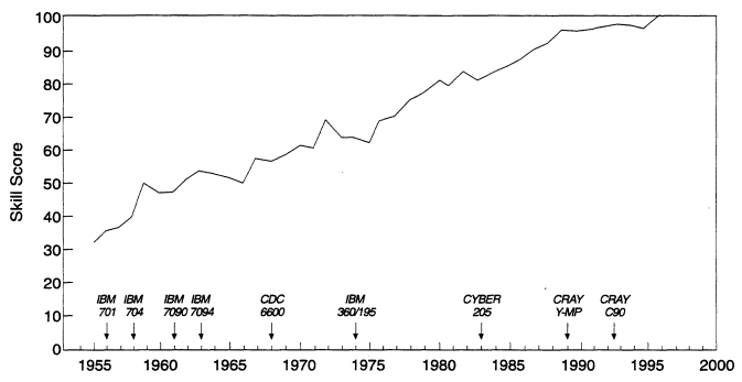
FIGURE 2-1
The variation since 1954 at NCEP (formerly the National Meteorological Center) in the skill score for 36-hour forecasts for the 500-mb geopotential height field over North America. On this scale, a score of zero represents an essentially worthless forecast (one with little or no skill). A score of 100 represents a highly accurate (nearly perfect) forecast. Also shown in the figure are the times of major computer upgrades at NCEP and the names of the computers. These upgrades in computer power were essential for increasing forecast skill.
Source: NCEP, personal communication.
with improved resolution and physics, new observing systems, and new methods of assimilating data have increased the accuracy of forecasts. Figure 2-1 shows the increase in skill of NCEP forecasts since 1955, using one simple measure of forecast skill: the forecast height of the 500-mb constant pressure surface over North America 36 hours after the initialization time.5 Figure 2-2 shows the corresponding skill in forecasting sea-level pressure.
Figure 2-3 shows the increase in skill at NCEP in forecasting the 500-mb geopotential height anomalies over the Northern Hemisphere in winter. An anomaly correlation of 0.6 or better is generally considered to represent a fairly accurate forecast. According to this measure, forecasting skill has more than doubled since 1972; a five-day forecast in 1998 is as accurate as a two-day forecast was in 1972.
The increases in forecast skill shown in Figures 2-1 and 2-2 are somewhat misleading because the weather of interest is far more complex than the behavior of the heights of the 500-mb pressure surface or the sea-level pressure field. There is a long way to go before forecasts of rain, snow, severe weather, and other phenomena will be as accurate as is theoretically possible. For example, the skill score for 24-hour forecasts of precipitation amounts of 0.5, 1.0, and 2.0 inches has increased only modestly since 1961 (Figure 2-4). However, progress is being made, as shown by the increasingly frequent forecast successes that would have been impossible 25 years ago. Box 2-3 describes the remarkable five-day forecast of the East Coast superstorm on March 12-14, 1993.
This issue of forecast success raises some serious questions. Given the improvements in NWP in the past 50 years, what can one reasonably expect in the next 25 years? How will weather services and the manner of delivering these services be affected? The panel believes that an ambitious but achievable goal for 2025 is that the forecast skill of global NWP models will approach the theoretical limit of skill as described by predictability theory.
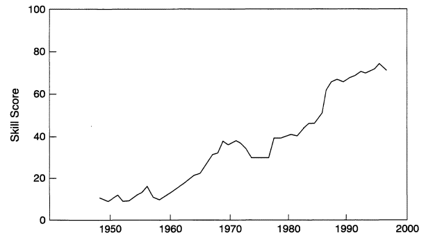
FIGURE 2-2
The variation since 1949 at NCEP in the skill score of 36-hour forecasts for the sea-level pressure field over North America. The skill score is on the same zero to 100 scale as Figure 2-1.
Source: NCEP, personal communication.
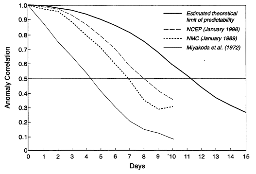
FIGURE 2-3
Anomaly (variation from seasonal climatic norm) of the height correlation for 500-mb forecasts. The curves labeled "Miyakoda et al. (1972) " and "NMC (January 1989)" are from Bonner (1989). The curve labeled "NCEP (January 1998)" was provided by Ronald McPherson of NCEP. The curve labeled "estimated theoretical limit of predictability" is a subjective and possibly optimistic estimate by the Road Map Panel, based on various quantitative estimates of the predictability of synoptic-scale waves in the atmosphere, such as Simmons et al. (1995).
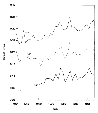
FIGURE 2-4
Skill in forecasting precipitation amounts over the United States (0.5, 1.0, and 2.0 inches) one day in advance. Each line represents the threat score, which is based on the degree of agreement between the forecast and observed area coverage of precipitation isohyets (lines of equal amounts of precipitation). If the area of a given forecast amount of precipitation is denoted by Af, the area observed by Ao, and the area correctly forecast (overlap of Af and Ao) by Ac, then the threat score is given by Ac/(Af +Ao-Ac). The threat score varies from zero (no area correctly forecast) to 1.0 (perfect overlap between forecast and observed areas of precipitation amounts).
Source: Olson et al., 1995.
Current Status
The current status of several representative operational and research models is summarized in Table 2-2. Operational global models are being run daily out to more than two weeks at approximately 100 km horizontal resolution at NCEP and 60 km at the European Center for Medium-Range Weather Forecasts (ECMWF). The regional Meso-Eta model at NCEP is being run at 32 km horizontal resolution out to 48 hours. Fully coupled atmosphere-ocean climate system models with approximately 300 km horizontal resolution in the atmosphere and 200 km horizontal resolution in the ocean are being run to simulate several hundred years of the Earth's climate (Boville and Gent, 1998).
Mesoscale and microscale research models with horizontal resolutions much higher than the operational models are being run to simulate and study a wide variety of nonhydrostatic atmospheric phenomena, including thunderstorms, tornadoes, hurricanes, other precipitation systems, and clear air turbulence and fires (see Table 2-2). For example, the Clark-Hall model developed by the National Center for Atmospheric Research (NCAR) has realistically simulated forest fires with an 84 x 84 x 160 grid using a resolution of 20 m.
Projections for 2025
Today's large-scale weather forecasts are useful for 7 to 10 days. Thus, current NWP forecasting techniques are probably about half way to the predictability limit. Reaching the limit will require improved model physics, significant improvements in global observations, and higher model resolutions. Although programs to improve the global observations are progressing well, they must be accompanied by advances in scientific understanding and computational power.
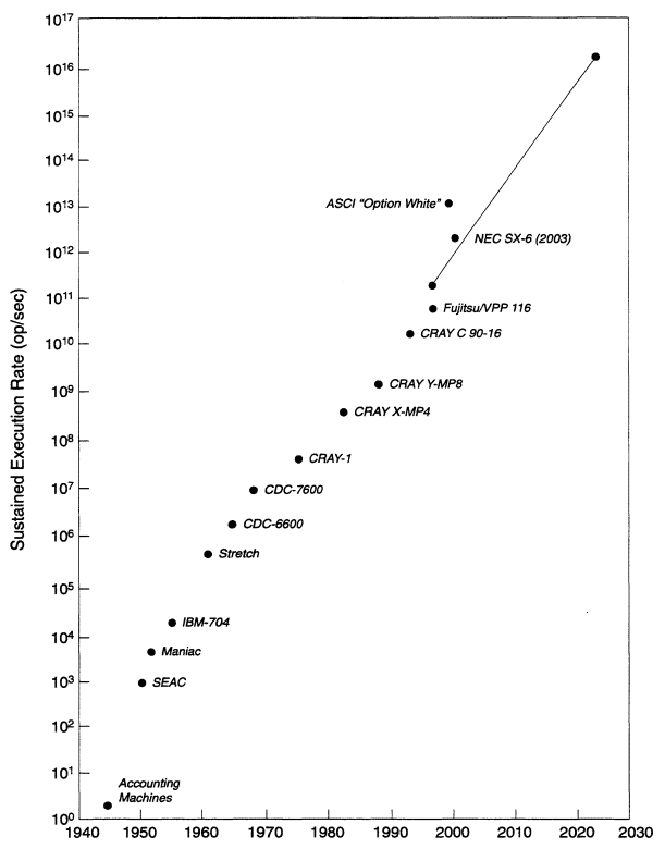
NWP has been one of several driving factors in the push for more powerful computers. The panel assumes that this will be true in the future and that the computer power available for NWP will continue to reflect the state of the art in processing capability. Figure 2-5 shows the increase in computer speed for a number of computers that have been used at NCEP and other weather prediction centers, as well as some projections into the future based on the accelerated strategic computing initiative (ASCI), an ambitious research and development program of the U.S. Department of Energy. Also shown in this figure are projections to 2025 listed in Box 2-4.
The differential equations used by NWP models are nonlinear and can only be solved analytically for highly simplified problems. In order to solve the equations on computers, equations are expressed either in finite difference form and solved algebraically at discrete locations (model grid points) or they are expressed as a series of wave functions (e.g., Legendre polynomials). Both methods introduce errors. In the first case, errors arise from the estimation of continuous derivatives by finite differences between data at discrete points. In the second case, errors arise through ending the series representation at a finite number of waves. In both cases, numerical errors grow as the forecast proceeds.
The resolution of grid point models is expressed as the spatial distance between calculation points. The resolution of spectral models is expressed in terms of the type of formulation (rhomboidal or triangular, denoted by R or T) and the number of waves that are used to represent a field. Even in spectral models, vertical structure is represented in finite difference form through operations on variables at discrete model levels.
High resolution in models is important for two reasons, to reduce truncation errors and to resolve finer scale phenomena. Resolution determines the scale of phenomena that the models can resolve and predict. The limiting factor in model resolution has always been—and will continue to be—available computer power.
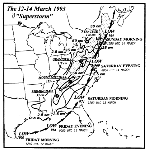
TABLE 2-2 Examples of Current Numerical Models
|
Numerical Modela |
Horizontal Resolution |
Number of Vertical Levels |
Period of Forecast or Simulation |
|
Operational, Global Models |
|
|
|
|
NCEP medium-range forecast |
105 km |
28 |
16 days |
|
ECMWF medium-range forecast |
60 km |
31 |
10 days |
|
Canadian global |
100 km |
28 |
10 days |
|
Operational, Regional Models |
|
|
|
|
NCEP Meso-Eta |
32 km |
45 |
48 hours |
|
Air Force MM5b |
36 km (12 km inner nests) |
10 |
24 hours |
|
Canadian regional |
24 km |
28 |
48 hours |
|
Research, Regional or Storm-Scale Models |
|
|
|
|
ARPS SAMEX |
3 grids (32, 9, 3) |
- |
|
|
36 hours |
|
|
|
|
ARPS coupled hydrology |
4 grids (64, 16, 4, 1) |
49 |
36 hours |
|
ARPS lake effect |
5 grids (64, 16, 4, 1, 0.25) |
41 |
24 hours |
|
CSU RAMS, supercell thunderstorm and tornado |
6 grids (120,40,8,1.6,0.4 and 0.1 km) |
32 |
13 hours |
|
CSU RAMS, cirrus simulation |
150 m |
115 |
30 minutes |
|
CSU RAMS, derecho |
4 grids (80,40,10, 2 km) |
38 |
24 hours |
|
MM5 (1987 TAMEX) IOP13 rainbands) |
6 grids (90, 45, 22.5, 7.5, 2.5, 0.83 km) |
27 |
48 hours |
|
MOZART (chemical transport model) |
-300 km |
25 |
2-3 years |
|
NCAR MM5 (Supertyphoon Herb, 1996) |
4 grids (60, 20, 6.67, 2.23 km) |
27 |
48 hours |
|
NCAR Clark-Hall, clear air turbulence |
5 grids (25.6, 6.4, 1.6, 0.4, 0.2 km) |
- |
|
|
7 hours |
|
|
|
|
NCAR Clark-Hall, fire |
20 m |
160 |
-30 minutes |
|
a ECMWF = European Center for Medium-Range Weather Forecasts; NCEP = (U.S.) National Centers for Environmental Prediction; MM5 = Mesoscale Model Version 5 (developed by Pennsylvania State University and NCAR); ARPS = Advanced Regional Prediction System (originated at University of Oklahoma); SAMEX = storm and mesoscale ensemble experiment; CSU = Colorado State University; RAMS = regional atmospheric modeling system. b The U.S. Air Force has recently begun to use a version of the MM5 model on an operational basis. Other versions are used for research. |
|||
|
BOX 2-4 Available Computer Power Moore's Law, which is actually an empirical generalization, predicts that computer power will double, on average, every one to two years, and computer power available at major weather prediction centers has roughly followed that law ([URL: HtmlResAnchor www.hedweb.com/nickbb/superintelligence.htm]). If this trend holds, computer power will double approximately every 18 months, or quadruple every three years, from now until 2025. The table below uses the Moore's Law relation to estimate computer speed through 2025, given the peak speed for the world's fastest computers, at present approximately 1 teraflop (1012 floating point operations per second). Figure 2-5 is a graph of historical values for peak speed, plus an extrapolation out to 2025, using the data in the table below.
|
Global Models in 2025
Global weather predictions and climate models in 2025 will include the ocean, land, and atmosphere in a single system. These models will be used for routine daily weather forecasts and, in a somewhat lower resolution version, for much longer periodic climate forecasts used as the basis for forecasts of anomalous weather conditions associated with large-scale, persistent ocean features, such as the El Niño Southern Oscillation.
To estimate the possible horizontal resolution of global NWP/climate models in 2025, one must make assumptions about the types of models that will be run, the available computer power, and the relationship between model resolution and computer speed. The panel anticipates that there will be three types of global models in 2025:
- coupled ocean, atmosphere, land, and sea ice models, also called atmosphere-system models (ASMs)
- coupled atmosphere-chemistry models
- space weather models
The estimates in Boxes 2-4 and 2-5 relate to ASMs; the panel assumes that the requirements for the other two types of models will be approximately the same. However, resolution is not the only factor that limits forecasting skill. Errors in initial conditions caused by incomplete observations, observational errors, and inadequate representations of atmospheric physics also contribute significantly to forecast errors. Advances in computer technology are likely to solve only the resolution problem. With advances in observational technologies, errors in initial conditions may become small enough that they no longer prevent NWP models from reaching the theoretical limits of predictability. Eliminating errors in the physical parameterizations of the models, the remaining constraint to reaching the predictability limit, will require significant increases in the basic understanding of the coupled atmosphere system and in translating this understanding into better model physics. This constraint is likely to be the greatest challenge to overcome, if the forecast skill of global NWP models is to reach the fundamental predictability limits by 2025.
Storm-Scale (Microscale) Models
The greatest advances in operational NWP in the next 10 to 20 years may be in storm-scale predictions. One can envision NWP systems with ultra high resolution (e.g., 1-10 m) that can capture features on time and space scales ranging from the scale of individual thunderstorms (roughly one hour) to the scale of organized features, such as squall lines, precipitation bands in cyclones, and mesoscale convective systems, that may last for several hours.
Based on the current state of research and projected computer capabilities, the NWS of the future will probably depend heavily on the operational use of limited area storm-scale models for short-range forecasts and warnings. By 2025, models with explicit representations of cloud and precipitation processes and horizontal resolutions of roughly 10 m will be capable of reliably predicting the life cycles of individual thunderstorms. With adequate initial conditions, these models will be able to predict the development and motion of individual storms for tens of minutes to perhaps a few hours. Storm-scale model forecasts will provide a basis for forecasters to issue site-specific warnings of flash floods, severe thunderstorms, and tornadoes. Small-scale features that are induced by topography and strongly affect local weather, such as land and sea breezes or mountain and valley winds, will also be predicted by these models.
In 2025, microscale models of air quality run by local environmental forecasters will contain appropriate representations for cloud, aerosol, and precipitation physics. Real-time data on industrial emissions of key trace chemicals (particularly the oxides of nitrogen and sulfur) will be assimilated into these local air quality and deposition models. Emission rates from traffic and natural sources, such as vegetation, will be added to the evolving emissions database, using specialized descriptions relating emission rates to external controlling factors. These models will be capable of predicting air quality for urban areas, where people susceptible to exposure to smog, and to air pollution in general, will be able to take protective action.
The models run by NCEP and other forecasting centers will include sufficient chemical detail to yield accurate forecasts of air quality affecting cities and other densely populated areas. The chemical weather forecasts will be tailored to provide requisite information for small-scale, area-specific air quality models run by commercial industries for forecasting local air quality. The predictions of these commercial vendors will constitute "value added" products that derive from NCEP chemical weather forecasts but that have been refined with information specific to the local topography, natural features, and built environment.
Space Weather
Causes and Consequences
The importance of space weather forecasts stems from the potential economic consequences of strong transient electrical currents in the ionosphere.6 These currents occur when a strong solar gust is captured in the Earth's magnetic field, rather than being repelled from it. The resulting damage to
power generating and transmission equipment can lead to a cascading breakdown of the infrastructure that supports modern, technology-dependent societies, including water supplies, heating and cooling systems, industries, and transportation systems. Depending on the area affected by the blackout and the extent of equipment damage, the economic costs could be as great as a billion dollars, and full recovery could take as long as a year. Living conditions in a blacked-out area could be stressed to the point that evacuations were required. "The magnitude of the disturbances triggered by solar flares is capable of disabling entire utility systems, and the worst is yet to come . . ." (Douglas, 1989). This comment was made in reference to the blackout in the Northeast United States in 1989 (the year of the last sunspot maximum in the 11-year solar cycle). A blackout in New York City in 1977 cost an estimated $290 million (OTA, 1990).
Solar gusts can disturb the Earth's upper atmosphere, which acts as a mirror and scatterer for over-the-horizon high-frequency (HF) transmissions and a medium for satellite signals. Radio communications, both ground-to-ground HF transmissions and satellite-to-ground links could be disrupted. During ionospheric disturbances, HF reflectivity could be lost in some regions, and satellite signals could scintillate, causing data errors. The GPS and GLONASS (Russian counterpart to GPS) navigation systems could be adversely affected in some geographic areas.
Satellite operations are also affected by gusts in the solar wind. In 1996, during the passage of a solar gust, a $200 million communication satellite was destroyed, presumably by electrical short circuits caused by high differential charge densities between the antenna and the satellite frame. Although this problem can be eliminated by changing the satellite design, astronauts in space during the passage of solar gusts will have to take extra safety precautions to protect themselves from the high charge densities and the high levels of radiation associated with solar flares.
Observing and Forecasting Space Weather
In January 1997, the Space Environment Center, which is operated by NOAA and the U.S. Air Force, successfully tracked a coronal ejection from the Sun as a solar wind gust to a violent magnetic disturbance on Earth (Peredo et al., 1997). The center's forecasts and other services cover ionospheric conditions; energetic particle fluxes at satellite orbits; solar events, including solar flares, solar particle fluxes, and geomagnetic storms; density variations in the upper atmosphere; and conditions affecting the propagation of HF radio waves. The center also provides detailed post-event analyses of problems in operational systems to determine the extent to which the space environment was a contributing factor (OFCM, 1997).
Current thinking about the need for observations of solar weather forecasts is based on solar wind gusts that originate at the Sun and travel through space to and beyond the Earth. The particle flux from a gust enters the Earth's upper atmosphere at the polar caps and propagates to lower latitudes in the ionosphere. To measure the sunspot activity on the disk of the Sun and the ejections of particles and plasma waves from the corona, solar observations will be made at and near optical wavelengths and in the microwave region. The solar wind in space will be observed by probes on the Advanced Composition Explorer (ACE) satellite at the Lagrangian point (about a million miles from the Earth in the direction of the Sun). Satellites of the Solar Terrestrial Physics "observatory" will supplement the ACE observations.7 The entry of a gust into the upper atmosphere can be observed and the motion tracked by a chain of diagnostic radars in the arctic region. The technology for these observations is already in place. The National Science Foundation and the Air Force plan to build radars near the magnetic pole and near the auroral oval. GPS signals can be measured with space-based or ground-based receivers to provide information on the electron density structure of the ionosphere.
The data, in the form of plasma densities and their variations, solar wind speeds, and ionospheric electron densities as a function of time and position, will be fed to the Space Environment Center for assimilation and analysis. A model of the Sun's activity on the disk and in the corona, starting with current data, will project solar activity for one or two rotations of the disk. Outputs from the model of the Sun's activity will be the inputs for the model of the solar wind, which will predict the speed and density of the solar wind from the Sun past the Earth and estimate the arrival times of gusts at the Lagrangian point and at the Earth. The motions of solar gusts in the polar upper atmosphere will be validated and modeled as circulating winds and storms on the quiescent models of the polar cap (Matuura and Kamide, 1995). The Space Environment Center will use the models to prepare nowcasts and forecasts of space weather (Spotts, 1998).
Operators of satellites for communications and navigation, operators of high latitude HF communications systems, and the electric power consortia (the Electric Power Research Institute and the National Energy Research Center) will then be able to take appropriate remedial actions. The Space Environment Center will provide information on current space weather, warnings with an hour lead time, watches for the next few days, predictions of solar activity for the next month, and predictions of the 11-year sunspot cycle. The next sunspot maximum is expected to peak in late 1999 or early 2000, when annual average activity is expected to be the highest in the 128-year record. Severe geomagnetic storms are likely from 1999 to 2005 (Joselyn et al., 1997). Timely research on solar-terrestrial physics by universities and applications to impacted systems in industrial consortia and laboratories might mitigate the life-threatening and economic consequences of these storms.
Advanced Forecasting Techniques
This section highlights four of the emerging techniques in forecasting that are closely linked to recent advances and unresolved issues in meteorology and hydrology: hybrid forecasting, probabilistic forecasting, distributed hydrologic modeling, and quantitative precipitation forecasting (QPF). Not every emerging technique is covered here. The selected techniques would substantially improve forecasting but will require advances through research or development, or both, to realize their full potential.
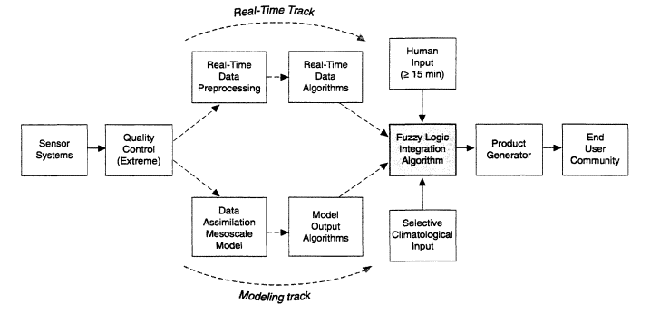
FIGURE 2-6
Using rule-based logic to develop specialized forecasts. Source: Wagoner, 1998.
Hybrid Forecasting
Innovative forecasting techniques combine observations, mesoscale NWP guidance, numerical modeling, climatology, and human input in expert systems that use rule-based or fuzzy logic interpretive schemes to develop specialized weather forecasts and products. Figure 2-6 illustrates this approach to hybrid forecasting. These expert weather analysis and forecast systems tend to eliminate the distinctions and separations among types of weather data and instead produce weather-related decision aids of direct interest to specific users.
An example of an expert system used for hybrid nowcasting is the Integrated Terminal Weather System (ITWS), which is being implemented by the Federal Aviation Administration for short-term, high-resolution forecasts and warnings in the vicinity of major airports (OFCM, 1997). This system uses data from multiple Doppler radars (NEXRAD, Terminal Doppler Weather Radar, and airport surveillance radar), surface observations from the Advanced Weather Observing System and Low Level Windshear Alert System, a lightning detection network, and measurements from sensors on aircraft. Observations from these sources are assimilated by the ITWS processor, which transmits forecast products directly to air traffic controllers as simplified graphic displays. These near-real-time displays are used to identify microbursts, low-level wind shears, gust fronts, storm location and motion, tornadoes, and strong winds in the terminal area. This type of integrated approach could be tailored to meet the needs of other users, such as the construction industry, road authorities, and managers of sporting events.
Another prototype for a hybrid nowcasting system for local or regional applications is the Automatic Thunderstorm Nowcasting System, which is under development at NCAR (NCAR, 1998a). This system integrates observations from radars, satellites, surface mesonets, and sounding data, together with numerical guidance, to predict convective activity every 30 minutes. Another system is the Wind Shear and Turbulence Warning System (WTWS), which is used at the new international airport in Hong Kong (NCAR, 1998b). Designed to produce forecasts and nowcasts of terrain-induced turbulence and wind shear, the WTWS uses the Terminal Doppler Weather Radar, wind profiler and other local observations, mesoscale model runs, and empirical results.
The promising results from these early systems indicate that hybrid forecasting will expand to serve a variety of users' needs. Expert weather systems could relieve forecasters at NWS field offices of the burden of examining diverse, asynchronous, rapidly changing observational data. Applications for hybrid nowcasting systems could include producing flash flood advisories, predicting the ground track for hail, or predicting the location of convective storms. In aviation, expert weather systems could quantify icing potential and forecast clear-air turbulence. In agriculture, one can envision the microscale management of water resources for
irrigation based on soil moisture, precipitation measurements and forecasts, as well as hydrologic and crop models. Even with these expert analysis and forecast systems, people will play an important role by adjusting data inputs and exercising overall quality control. Moreover, their experience with the use of these systems will be a key element in the continuing development of improved systems and new applications.
Nowcasting systems that assimilate multisensor estimates of precipitation fields and then make statistical extrapolations can quickly produce multiscale estimates of near-term precipitation. With an expert weather system for nowcasting, the season of the year, local topography, and local climatology can all be factored into the nowcast of precipitation. These precipitation estimates will in turn provide crucial input to local and regional hydrologic models.
Probabilistic Forecasting
NWS has issued probabilistic forecasts of precipitation for more than 20 years and of hurricane strikes for nearly 10 years. In the future, probabilistic forecasts will become increasingly important because of both the growing number of uses for which probabilistic information will be beneficial or even essential (application pulls) and the capability to produce better forecasts (technology pushes). The panel foresees rapid growth in this area fostered by a combination of more sophisticated forecasting techniques and better ways of presenting probabilistic forecasts to decision makers.
The enabling technologies for probabilistic forecasting include improvements in modeling. For example, models could provide confidence limits as part of the gridded forecast results. Ensemble forecasting will improve as multiple model runs based on slightly different initial conditions become available.
Probabilistic representations of observational data—for example, radar data—will be available for direct use by customers. Probability data will also be used as input for meteorological and hydrometeorological models by NWS and other forecasters in the expanding weather information network.
Customer demand will determine which forecast results are represented as probability distributions and how distributed results are represented. Emergency managers, who are becoming skilled in risk management based on probabilistic decision aids, will be looking for probabilistic results from NWS that can be used as direct inputs to these computer-based tools. The business and financial communities can be expected to take the lead in developing new risk management techniques that incorporate probabilistic observations and forecasts. The increasingly sophisticated models used by insurance companies, commodity futures brokers, and transportation and energy companies (to name a few examples) will require large domains of information, including weather observations and forecasts.
Potential uses of probabilistic warnings include predictions of flood stages based on hydrologic modeling for river and larger stream systems, and flash flood warnings. Probabilistic forecasts of the severity of large-scale winter storms can be communicated to public authorities who have to decide whether or not to make emergency preparations. Forecasts of seasonal variations from climatic norms will become increasingly important for business planning. Climatic trends, such as "global warming" or changing regional precipitation patterns, will be represented in probabilistic terms, first to establish the existence of the trend, then to describe the amount of change over a given period.
Advanced Hydrologic Forecasts and Warnings
Hydrologic hazards, such as flooding rivers and flash floods, will continue to pose serious risks to people and property. New user requirements will also emerge, especially in terms of assessing and ensuring water quality and long-lead predictions to facilitate decisions for managing sectors and activities that are sensitive to hydrologic variations. To take advantage of the opportunities created by advances in science and technology, the WS should continue the integration of meteorological and hydrologic data and modeling that began during its modernization and restructuring.
Ground Hydrology Modeling Based on Spatial Distributions of Physical Conditions
Recent scientific advances and technological innovations have led to a fundamentally new approach to operational hydrology and the difficult problem of hydrologic forecasting. A new generation of hydrologic models will be based on characterizing the spatial distribution, over a drainage area, of physical hydrometeorological and hydrologic processes. Distributed hydrologic modeling should replace the spatially lumped soil moisture accounting approach still used by the NWS. Besides being more realistic, the next generation of models will yield an entirely new suite of forecast products.
By assimilating recent observations of soil moisture, groundwater level, and snow pack conditions from monitoring sites into mathematical representations of the controlling physical conditions, the stage or flooding level in streams and rivers can be forecast with spatial and temporal continuity. In other words, a forecast over time can be made for any node or link in the drainage network. This approach to hydrologic forecasting will provide a unified and consistent approach for forecasting both mainstem floods and flash floods of smaller streams. Forecasting of flood hazards would be continuous, from flash floods with lead times measured in hours, to river floods, with lead times of days or, for snow melt, weeks.
Distributed hydrologic models can be scaled to both smaller and larger basins and can be transferred to other basins, if the same physical processes apply. Differences related to scaling or transfer would be captured in the
observational data sets used to initialize the model, rather than being expressed intrinsically in the modeled relationships, as they are in soil moisture accounting.
Another advantage of distributed hydrologic modeling is its capability to assimilate estimates of precipitation fields derived from radars, satellites, and surface observing systems. These estimates, which will have high spatial and temporal resolution, can capture the mesoscale structure of rain intensity, which will have significant implications for estimating the magnitude and timing of floods.
Broader Applications of Distributed Hydrologic Modeling
In addition to mitigating flood risks, distributed hydrologic information (e.g., soil water contents, snow pack conditions, groundwater levels, and river stages) will become much more useful to customers. Forecasts of river discharge at every link in a drainage network will help water resource managers and utilities to optimize delivery operations. Detailed predictions of water levels and flows for an entire drainage system will help managers ensure the quality of water and protect habitats (e.g., fish populations and wetlands). Distributed models of soil moisture can be fed into hydrologic analyses of groundwater levels to manage the transport of environmentally significant chemicals (e.g., nutrients, pollutants, and indicators), as well as to support models of the ecological roles of soil moisture and waterborne chemicals.
Distributed hydrologic modeling could also significantly improve meteorological forecasts. Mapping and monitoring soil water across the landscape will improve the utility of NWP models by providing initialization fields for land surface, as long as the variables in distributed hydrologic models and NWP land surface parameterizations are compatible. The results of a run in one model would provide initializing and boundary conditions for the next run of the other model type. Atmospheric and soil moisture models would be especially beneficial during the summer months when convective storms are affected by buoyancy near the surface. Correct initializations for soil moisture will improve predictions of surface flux (e.g., latent heat and sensible heat) and changes in meteorological and climatological forcing factors on virtually all scales. The NWP model will produce ensemble fields for QPF, which will extend the lead time of hydrologic forecasts and make probabilistic forecasts feasible for both precipitation and drainage flow. Even fire weather forecasts will be improved by information on soil water and vegetation status, which can be derived from the distributed hydrologic model.
Potential Extensions to Models of Physical Processes
Sophisticated distributed hydrologic models will include soil physics and vegetation processes. Thus, auxiliary sets of data relevant to soil science and terrestrial ecology, such as surveys of soil texture and remotely sensed conditions of vegetation canopy (structure and photosynthetic function), could replace the empirical fitting parameters of soil moisture accounting models. Spatial snow pack conditions in a distributed model, as well as the soil moisture fields, could be initialized and updated using satellite measurements
Ultimately, distributed hydrologic models will be fully integrated with regional NWP and nowcasting models for atmospheric processes. Data assimilation (input) and forecast integration (output) could be made fully compatible across this suite of interactive models. The regional land atmosphere or hydrometeorological system could also incorporate, or could be linked seamlessly to, user applications, such as models of water quality, reservoir operations, and urban hydrology.
Quantitative Precipitation Forecasting
Although QPF is not a new forecasting technique, the utility of these high-resolution forecasts of the geographic and temporal patterns of precipitation intensity and type could be greatly improved. Although skill scores for QPFs have steadily increased over the past 30 years as a result of improvements in both NWP and the characterization of atmospheric fields, the scores are still relatively low (Olson et al., 1995; see Figure 2-4). Emerging observational technologies and advances in modeling will significantly improve the accuracy and reliability of QPFs in the next quarter century.
Multisource upper-air observing systems will capture more of the small-scale features and sharp variations in atmospheric conditions that are critical for accurate representations of thermodynamic fields in storm-scale models, which could predict the track and evolution of precipitating systems. These small-scale features are essential for extending the time of short-term precipitation forecasts beyond their current limit of several hours. Better characterizations of three-dimensional water vapor may be the largest single contributor to improving QPFs. If radar and satellite precipitation measurements could be included in data assimilation schemes, the tightly coupled system of observations and high-resolution, storm-scale models would improve forecasts of precipitation between the one-to-two hour nowcasts and the one-to-three day forecasts based on NWP models. For longer forecasts, the specifications for surface-condition parameters and boundary conditions would increase skill scores for QPFs of less than 12 hours.
Implications for the National Weather Service
Advances in three essential areas-observational technologies, computational technologies, and scientific understanding-will contribute to the development of more sophisticated analysis and forecasting techniques and more
accurate, precise, and reliable numerical forecast models (NRC, 1998e). To realize the enormous potential of these capabilities for providing weather, climate, and other environmental information to a variety of customers, the NWS and NOAA must address a number of issues related to new observational systems, the acquisition of state-of-the-art computer systems, scientific research, and the development of advanced forecasting techniques (Dutton et al., 1998).
Upgrading Observing Systems
Despite the sophistication and elegance of existing observational systems, they cannot meet the growing need for accurate forecasts and warnings at higher spatial and temporal resolutions. In fact, no single instrument or platform will be able to provide all of the necessary meteorological observations. A combination of instruments and platforms will provide the most cost-effective and accurate total system. Recent studies (e.g., Stankov, 1998) have shown that systems that integrate measurements from multiple, diverse, remote sensing and in-situ instruments provide a better estimate of the true state of the atmosphere than any single instrument. Thus, emphasis at the NWS should be on developing a total system of synergistic, cost-effective instruments and platforms.
This development effort should begin by obtaining maximum benefit from the existing suite of remote and in-situ measurement systems. In pursuing this goal, the NWS must achieve four objectives:
- Make the resource commitments necessary to ensure that all data are of the highest possible quality and accuracy. For example, NWS must receive and commit the resources necessary to maintain and calibrate all of its sensing systems in accordance with the standards set for their performance.
- Develop new single and multiple parameter interpretative techniques applicable to the existing observing systems and the full suite of observations obtainable from them.
- Develop more comprehensive methods for assimilating the entire suite of observations into coupled NWP models that make full use of this information.
- Provide sufficient fiscal and staffing resources at NWS field offices and centralized facilities to progress rapidly in realizing the full potential of the technical systems already in place.
Realizing the panel's vision of weather services in 2025 will also require many improvements in observing systems:
- Future observing systems must fill the existing gaps in data fields, including data from remote regions, especially over the oceans and the poles. New systems and techniques, such as observations from GPS/MET satellites, should be considered and tested. In addition, much higher resolution NWP models will require a higher density of point observations and higher resolution of remotely observed fields in all three spatial dimensions and in time.
- Techniques for making quantitative observations of certain variables or characteristics that are now observed poorly, or not at all (e.g., vegetation, soil moisture, or the amounts of water and ice in clouds), will have to be improved or developed.
- The evaluation of existing and potential observing instruments individually or as part of an integrated instrument suite should be conducted systematically. These evaluations are generally conducted by means of observing system simulation experiments, in which the observations from one or more instruments are assimilated into NWP models to determine the improvements in predictive skill.
To facilitate evolutionary, incremental upgrades in technology and the transfer of new observational developments into operations, the NWS will have to improve its capabilities for rapid prototyping and system testing. One of the lessons from the NWS modernization is that an evolutionary approach to upgrading technology is preferable to the NWS's past approach of making radical overhauls after years of minimal improvements. An incremental approach will require that the NWS, as well as the research and user communities, be willing to give up obsolete, or sometimes still useful, operational technologies or practices to free human and fiscal resources for newer, more effective technologies and practices.
Regaining and Maintaining State-of-Practice Computer Facilities
The panel is concerned that NWS computer capabilities at NCEP have fallen well behind the state of practice as represented by the capabilities of meteorological centers of many other industrialized nations (Table 2-3). One ominous consequence is that NCEP can no longer develop, test, and run the NWP modeling systems with the highest resolution and greatest accuracy and completeness in representing important physical processes, such as precipitation, radiation, turbulence, and atmosphere-ocean interactions. The issue is not one of "keeping up with the Joneses," in the sense of merely indulging national or institutional pride in having at least as much new technology as other weather services. Rather, the issue is the value of having adequate computer power to provide the most beneficial information to the U.S.
TABLE 2-3 Supercomputing Capabilities at Operational Weather Prediction Centers, March 1998a
|
Meteorological Forecast Center |
Vendor |
Machine |
Number of Processors |
Effective Speed (gigaflops) |
|
North America |
|
|
|
|
|
U.S. NWS (NCEP) |
SGI/Cray |
C916 |
16 |
5 |
|
US. Navy NAVOCEANOb |
SGI/Cray |
T3E-900 (primary) |
544 |
47 |
|
|
0200 |
128 |
13 |
|
|
|
T932 |
12 |
15 |
|
|
U.S. Navy (FNMOC)b |
SGI/CRAY |
C916 |
16 |
5 |
|
Canada |
NEC |
2 SX-4/32 |
64 |
48 |
|
Europe |
|
|
|
|
|
European Union (ECMWF) |
Fujitsu |
VPP-700 |
116 |
80 |
|
Denmark |
NEC |
SX-4/16 |
16 |
10 |
|
France |
Fujitsu |
VPP-700 |
40 |
28 |
|
Germany |
SGI/Cray |
T3E-LC400 |
432 |
26 |
|
United Kingdom (U.K. Met Office) |
SGI/Cray |
T3E-900 |
840 |
76 |
|
Asia-Pacific |
|
|
|
|
|
Australia |
NEC |
SX-4/32 |
32 |
24 |
|
Japan |
Hitachi |
S-380 |
4 |
10 |
|
a Sustained performance is calculated as 31.25 percent of peak performance for vector machines and 10 percent of peak for the massively parallel T3E machines. b NAVOCEANO = Naval Oceanographic Office; FNMOC = Fleet Numerical Meteorology and Oceanography Center. Sources: The information was compiled by members of the panel from information provided by Bill Buzbee, Director, NCAR Scientific Computing Division, from various websites on the Internet World Wide Web, and from personal communications with individual forecast centers. |
||||
public and to U.S. economic interests through state-of-the-art operations for centralized data assimilation and forecasting.
History shows that improvements in NWP forecasts are directly related to increases in computer power. Unless the NWS is committed to maintaining state-of-practice computer capabilities in NCEP operations, it will be unable to meet the needs of users for more accurate and precise weather forecasts, especially for longer forecast periods. Consequently, the nation will not reap the full benefits of its ongoing investment in weather observations and weather forecast research. Failure to invest in NCEP computers will limit the availability and accuracy of day-to-day forecasts (one day to the limits of deterministic predictability) and forecasts of large-scale climatic events, such as the El Niño Southern Oscillation and its associated weather patterns. Because of the importance of using accurate boundary conditions from global models to run local or storm-scale models, these limitations will also affect the entire forecast and warning system.
There appear to be two principal obstacles to relieving the computational bottleneck: (1) delays in budget appropriations for the acquisition of NCEP computers, and (2) fewer technology options for NCEP than are available to forecast centers in other countries. These are serious problems, and the NWS must work with NOAA and the U.S. Department of Commerce to communicate the consequences to the administration and congressional authorizing and appropriating committees. A common understanding among these parties will be essential for exploring effective, practical, politically acceptable solutions.
Advances in Scientific Understanding
The major requirements for accurate NWP forecasts are more improved model physics, more complete global observations, and adequate computer power. If computer power continues to double about every 18 months, and if the NWS has access to the world's most powerful computers, the first requirement would be met. The only feasible way to obtain accurate observations worldwide, at the required temporal and spatial densities, is through remote sensing. Thus the NWS should support the rapid development, testing, and deployment of innovative remote sensing concepts, including those based on microsat technologies. The expeditious implementation of these technologies will require that NCEP' s research staff be able, first, to develop and test the data assimilation schemes for using the new observations, and second, to evaluate their impact on forecasts. In the judgment of this panel, based on familiarity with NCEP staff and budget resources, current NCEP resources in the critical area of research and implementation on data assimilation are woefully inadequate. To reap the practical benefits of the nation's substantial investments in satellite and ground-based remote sensing systems, data assimilation capabilities at NCEP and other operational weather centers will have to increase significantly.
To address the limitation in model physics, the NWS should take advantage of extensive research at universities and national laboratories on realistic, accurate parameterizations of physical processes. Known limitations in NWP models include the treatment of the physics of clouds and precipitation,
long-wave and short-wave radiation, boundary layer processes, and most important, the interactions among them. The NWS need not take the lead in research, but it should enter into partnerships with the research community, through programs such as the U.S. Weather Research Program (USWRP), for the development and rigorous testing and evaluation of promising new data sources, models, analysis techniques, and physical parameterizations.
The forecast techniques and models for predicting both chemical weather and space weather are much less mature than those for predicting conventional weather and for issuing warnings. Improving forecasts of chemical weather and space weather will require significant research in observational techniques, data assimilation, and model development and testing. The NWS roles should be to: (1) work with the research communities in developing and evaluating prototype numerical forecast models and (2) as soon as possible, begin making and verifying experimental forecasts based on the best available models. For chemical weather predictions of air quality, NOAA and the NWS should coordinate and expand partnerships with the Environmental Protection Agency and other federal, state, and local governmental entities to determine observational and forecast needs and the best ways of disseminating chemical weather information and air quality warnings.
Advanced Forecasting Techniques
Advances in artificial intelligence and knowledge representation have led to the development of smart weather information systems, which combine data from many sources, model predictions, climatology, and statistics to produce more accurate forecasts than can be produced by a single model or forecasting technique. The panel expects that hybrid nowcasting methodologies, as well as probabilistic forecasting techniques, will proliferate in the years -ahead. The NWS should support (with budgetary and personnel resources, as appropriate) and strongly encourage the development, testing, evaluation, and implementation of these systems.
The NWS will have to adopt innovative approaches to the development, implementation, and support of distributed hydrologic models; the assimilation of data into these models from the full suite of radar, satellite, and surface observing systems; and the integration of hydrologic models with atmospheric models. In an earlier report, the National Weather Service Modernization Committee recommended that the NWS increase its efforts to meet these objectives (NRC, 1996a). The NWS should look forward to what needs to be accomplished, rather than looking back to what has been considered acceptable. The computer technology required to implement and run these large numerical models is at hand. The scientific basis for the models has been advanced by the research community. But the implementation of advanced forecasting systems will require greater support and commitment by NWS managers and greater attention to operational applications and training of NWS field staff.


