


Below is the uncorrected machine-read text of this chapter, intended to provide our own search engines and external engines with highly rich, chapter-representative searchable text of each book. Because it is UNCORRECTED material, please consider the following text as a useful but insufficient proxy for the authoritative book pages.
Appendix A Criteria for Evaluation of a Weather Radar System The criteria for comparison of the Next Generation Weather Radar (NEXRAD) and pre- NEXRAD systems fall into three broad areas: 1. 2. 3. technical aspects including detection capabilities; warning performance; and products and services offered. RADAR TECHNICAL ASPECTS This section provides a system description and radar performance specifications and discusses the key radar technical aspects that were considered in developing criteria for addressing the quality of radar coverage. Key radar technical aspects include coverage at specific altitudes, spatial and temporal resolution, sensitivity, Doppler coverage, and radar availability. Other technical aspects of radar operation (e.g., clutter suppression, antenna beam patterns, algorithms, and data archiving) are also discussed in this section. However, these did not enter directly into the evaluation of the detectability of weather phenomena for the "quality of service" assessment. The discussion of radar technical aspects concludes with a description of NEXRAD technical improve- ments. System Description The pre-NEXRAD NWS radar network consisted of 128 WSR-57, WSR-74S, and WSR-74C radars. The WSR-57 and WSR-74S radars, both LO-cm-wavelength systems, were configured as manually operated surveillance radars; the 68 WSR-74C, 5-cm radars functioned as "local warning" radars. The NEXRAD network, when complete, will consist of 138 lO-cm WSR-~8Ds in the contiguous United States, including 22 Department of Defense (DoD) radars. Beyond the contiguous United States, seven NEXRADs are planner! in Alaska, four in Hawaii, three in the Caribbean, and several other systems in locations around He world. 65
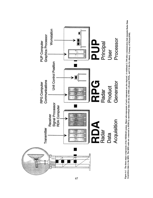
66 Appendix A Radar Performance Specifications Table A-! gives the technical characteristics of the NEXRAD and comparable values for the pre-NEXRAD radars. NEXRAD is a Doppler radar system that routinely generates products involving both reflectivity and velocity information. The reflectivity estimates of the NEXRAD have significantly higher data quality than the pre-NEXRAD systems due to higher spatial resolution of the narrow antenna beam, increased sensitivity to weak echoes, new Doppler clutter-suppression processing, and new calibration procedures. Radar coverage with limited Doppler capability was available in the pre- NEXRAD NWS network only at Montgomery, Alabama; Marseilles, Illinois; and Huntsville, Alabama. Therefore, for weather phenomena that can only be detected using Doppler features (e.g., mesocyclones or microbursts), limitations in the NEXRAD network Doppler coverage are not a factor for most of the country under the "no degradation of service" criterion. Where a combination of Doppler and reflectivity features is used for phenomena detection (e.g., supercelIs), limitations in the NEXRAD Doppler coverage could be a factor in those geographic areas where NEXRAD coverage at long range must be compared to pre-NEXRAD coverage at short range. TABLE A-1 Radar Characteristics-Pre-NEXRAD and NEXRAD NEXRAD WSR-57 WSR-74S WSR-74Ca P. = Transmitter peak output power (MOO)0.750 0.5000.5000.250 G = Antenna gain (dB)45.5 38.538.540 = Wavelength (cm)10.53 10.7110.715.33 t2 = Propagation loss (dB) @¢ 0.50 ~ 50km0.7 0.70.70.8 ~ 230 km2.5 2.52.52.8 al = Beam width (de")0.95 2.02.01.5 ~ = Pulse width Cases)1.57 4.004.003.00 Bn = Noise band width (MHz)0.79 0.751.500.80 TSYS = System noise temp (K)600 170010002150 Z.,,,,, = Min detectable dBZ ~ 50 km (single pulse) -7.6 -0.2 0.3 -1.7 Doppler Feature yes no no no Clutter Suppression yes no no no a The Huntsville, Alabama, WSR-74C has enhanced capabilities G = 43 dB, 8, = 1.0 decree ~ = ~ O psec, Z.,,,,, <-5 dBZ, Doppler and clutter suppression. _ ~, . _, The NEXRAD has three major components, as shown in Figure Am. These components are the radar data acquisition (RDA) unit, the radar product generator (RPG), and the principal user processor (PUP) (Crum and Alberty, 1993~. The RDA includes the transmitter, antenna, receiver, signal proces- sor, and Level 2 base data (wide band) communications interface. The RPG includes the computing power that generates the image products and the narrow band communications interfaces. The PUP is the processor workstation with which the forecaster requests and receives NEXRAD products. "Associ- ated" PUPs are permanently connected with the RPG and routinely receive specified sets of products. "Non-associated" PUPS are intermittently connected to any NEXRAD via a dial-up, low-speed communication line and receive only requested products.
o ~ - 'e ti; - o o co o Q o L o, CD C' a, ~ 0 'G) (15 ~-~ a) =o C: CO ho' a..... ma,.*....... o In a) a) can -_ o , ~ Q A ~ C,0 o ._ Q Q Q ~ In a) O ~ ._ , ~ C' E ·= o ~ Q o a' it: I_ ~- - CO _~ -- ~ .... - L .. ,. . . if:: ~%,-;.~- , , , ,., , ,-,,., ~''''b' I , I ~ ~- ~\\\\ l I //= - Q I_ ~ a) ~ cn c5 o cn ~n a cD ~o Q o =, C) Ct ct ~ au ~ c~ ° a) &_ ~ Q O _' _ _, _ ,' 1 , ~ - -- , . .: 1 67 o ._ · _ ~n _._ ~ Ct ~ Ct Ct C) G a' v ~s ·~; J4 .~ ~ ~ o o · C - 4 ~ o ·a ~ U. o ~ ~ . ~g ~ D ',4 O ~, _' _ 6o ~ 0\ 3 ~ · oo .O ~ - o ~q C C' ° ~ - o , ~; o c, o ~q ~n ~ . o ~ o 3 ~o ~q ~ o :^ ·~ ~D C~ · _ ~ ~o U) -V .e ~ ~ a5 o Z Ut o Z o ~ C, . o ~ ·~ o - -v 1 0 := ~ . .
68 Appendix A The Doppler capability of the WSR-88D allows measuring storm kinematics (i.e., velocity information) to generate more-accurate and timely weather advisories and warnings while suppressing interfering ground echoes; thereby improving short-range and low-altitude coverage. Another important design improvement is the availability of digital information in a variety of displays from the NEXRAD. Spatial Coverage In planning the layout of the NEXRAD network, consideration was given to the distribution of population within the contiguous United States. In meeting the needs of the sponsoring agencies, further siting criteria included proximity to existing or planned Weather Forecast Offices and to high-use commercial airports and designated high-value military facilities. On a smooth spherical Earth, the coverage provided by a particular radar would be limited by the curvature of the Earth and the refraction of the microwaves in the atmosphere. Because of those factors, the maximum range of potential coverage for a given altitude is represented by a circle with the radar located at the center. Due to blockage of the radar beam by intervening terrain features, however, the area actually covered at a given altitude is not circular in some cases (particularly in the West). When the coverage zones of all operational radars are plotted and superimposed, the resulting "coverage map" provides one of the aids for evaluating the adequacy of radar coverage. Maps shown later in this appendix illustrate this coverage, or radar field of view. Radar resolution, sensitivity, and the forecaster's expertise must be added to the field-of-view in determining overall quality of service. Generally the ability to detect weather phenomena decreases with increasing radar range because the low-altitude coverage, the radar resolution, and radar sensitivity all deteriorate with increasing range. In addition, there is a "cone of silence" above the radar, as illustrated in Figure A-2. This deficiency may be alleviated by observations from neighboring NEXRADs over most of the United States east of the Rocky Mountains. At close ranges (up to, perhaps, 40 km) the interfering effects of ground clutter are at a maximum." The NEXRAD clutter suppression feature mitigates this limitation to a considerable extent. At long ranges both the Earth's curvature and the increasing resolution cell size reduce the radar's ability to detect weather phenomena. These two features are illustrated in Figure A-3. For each weather phenomenon shown, no combination of resolution and sensitivity can compensate for the fact that the radar beam is simply too high above the grounc! for effective detection. Weather targets Hat protrude into the lower edge of Me beam may be detected because of the NEXRAD's sensitivity. The restrictive effect of the Earths curvature is a function of the height of the weather phenomenon and the degree to which signals received from high levels can be interpreted effectively in terms of weaker at lower heights. At long ranges, the width of the beam may prohibit resolution of fine details of Me echo structure needed to identify particular weather phenomena. Representative ranges for detecting various weaker phenomena are discussed in Chapter 2. The coverage at various altitudes for both the pre-NEXRAD and NEXRAD networks has been mapped. Figure A-4a shows Be NEXRAD altitude coverage, that is, where the NEXRAD coverage ~ All radars receive signals scattered from the ground. These signals are called "ground clutters because the returns interfere with the signals from weather targets and often obscure the weather signal entirely. This problem is particularly severe at close range (approximately out to 40 km) but is also strongly influenced by terrain, especially in hilly or mountainous regions. Cities with tall buildings also produce strong clutter signals that can obscure weather above them.
MELEES O DEGREES 11 ~ I ~ 11 COVERAGE IN CONE OF SILENCE \ ~ ~ ~ ~ FROM NEIGHBORING RADAR 345 km (186 nml) AWAY (REPRESENTATIVE SEPARATION DISTANCE WEST OF ROCKIES) HORIZONTAL SCALE, 1 INCH = 30 km VERTICAL SCALE, 1 INCH = 7.5 km SILENCE ~ ~7~ _ 40,000 fit__ ___ ____ SITE ~ O DEGREES I COVERAGE IN CONE OF SILENCE FROM NEIGHBORING RADAR 230 km (124 nmi) AWAY (REPRESENTATIVE SEPARATION DISTANCE EAST OF ROCKIES) ~1 VERTICAL EXAGGERATION, 4 TIMES Figure A-2 Cone of silence for the NEXRAD. The cone of silence has a radius of 34 km at 40,000 fit and a radius of 8.5 km at 10,000 ft. Elevations higher than 19.5 degrees are not scanned using the existing volume coverage patterns; therefore, radar echoes are not received from within this cone directly above each radar. Overlapping coverage from adjacent radars is needed to cover this region and is shown for two radars operating with a 1-degree beam width centered at 0.5 degrees elevation. Courtesy of SRI International. . ~ 0 OOO fit ye us to HORIZONTAL SCALE, 1 INCH = 50 km VERTICAL SCALE, 1 INCH = 2 km VERTICAL EXAGGERATION, 25 TIMES 1 1 1 1 0 40 80 - . . I. | to \ / O r,EGREES i, --- - . _ I · · !5 ° ~ I ~ by. in 1 1 1 1 1 1 1 1 1 120 160 200 240 RANGE (km) ~ ~E us /~>, ,~` TORNADO E ~S~w, j Figure A-3 Diagram illustrating the effect of range and earth curvature (with standard atmospheric refraction) on NEXRAD cross-beam resolution and coverage of low-level weather phenomena. Courtesy of SRI International.
70 Appendix A at 0.0 degrees flower half-power edge of a Degree beam that is centered at 0.5 degrees) extends down to or below 4,000 It (red), between 4,000 ft and 6,000 It (yellow), between 6,000 It and 10,000 ft (green), and between 10,000 ft and 40,000 ft (blue) above site level (ASL). All altitudes in the figure are given ASL. Figure A-4b shows a map indicating differences between the two networks in minimum-altitude coverage over the contiguous United States and bordering areas red indicating that the NEXRAD coverage reaches to lower altitudes than the pre-NEXRAD coverage, blue the converse, and green indicating regions of similar coverage. The blue areas indicate regions of potential degrada- tion of service with the NEXRAD network. The pie chart in Figure A-4b shows that the NEXRAD coverage is similar to, or better than, the earlier network over most of the contiguous United States. However, over about 7 percent of the area, the earlier network coverage extends to lower altitudes. Altitude coverage, alone, is not equivalent to service, however, as discussed elsewhere in the report and in this appendix. Resolution Spatial resolution is important from a meteorological perspective since better radar resolution (i.e., a smaller radar-resolution cell) allows detection of smaller-scale features, such as tornado circulations, mesocyclone circulations, and hail or rain shafts, at greater ranges. Spatial resolution is defined as the maximum dimension of the volume "illuminated" by a pulse. At close ranges the resolution is governed by the pulse length, and at long ranges it is governed by the antenna beam width. The narrower beam of the NEXRAD antenna gives it an advantage over earlier National Weather Service (NWS) radars in resolution capability at long range. Figure A-3 depicts the NEXRAD beam-width dimension as a function of range. Radar systems often average information over several adjacent resolution cells along the range direction to improve detectability and to measure the returned signal strength more precisely, but this is done at the expense of range resolution. In the NEXRAD reflectivity mode, four such ceils of 250-m length are averaged together to yield an effective range resolution of ~ km. Comparable range resolution was obtained from the pre-NEXRAD radars using longer transmitted pulses. Table A-2 gives . . TABLE A-2 Approximate Spatial Resolution Dimensions Radar Range Resolution Cross-Beam Resolution At: 6 km 60 km 180 km NEXRAD 1.0 km (reflectivity) 100 m 1.0 km 3.0 km 0.3 km (velocity) WSR-74C 0.5 km 150 m 1.5 km 4.5 km WSR-74S 0.6 km 200 m 2.0 km 6.0 km WSR-57 0.6 km 200 m 2.0 km 6.0 km
~- ~ ~ ~ 1 --, ! I -me ,' i i ~:~ ` ~TV rag 4 0OO f, (r t)' b talus) itu e verAge b regt al 5 cK Hi - 0 0 0 t t t 4 t;EXR D itam that I c t It d t \0'OO tt ~t . Fig -4a of tedder b 5,0 0 half prow I O ft (yetl°W), I ooo ft an] 6 ,00 of Spl Internatton v ct with reg (tit d coverage
Radar System Evaluation Criteria 73 the approximate spatial resolution of the base data for each of the radars at ranges of 6 km, 60 km, and, IS0 km. Note that cross-beam resolution at 60 km is ~ km for the NEXRAD and about 2 km for the pre-NEXRAD radars. Figure A-Sa shows the resolution of the NEXRAD network for the 10,000-ft ASL coverage. The colors on the figure indicate resolution dimensions of less than ~ km, between ~ and 2 km, and between 2 and 4 km. Figure A-5b compares the resolution capabilities of the two networks for 10, 000-ft coverage over the contiguous United States and bordering areas. The red areas indicate where the NEXRAD network provides better resolution; the blue areas indicate where the old network had better resolution capabilities; and green areas indicate where the resolutions were essentially the same. The blue areas do not imply a degradation of service but indicate regions that are candidates to examine for potential degradation of service. As indicated by the cumulative distributions in Figure A-6, the NEXRAD network will cover about 86 percent of the contiguous United States and bordering areas with resolution better than 4 km. (The percentage would be reduced slightly without the DoD radars.) The pre-NEXRAD network provided 4-km resolution over only 46 percent of the area. Temporal resolution is also important in observing rapidly evolving weather features. The NEXRADs operate on predetermined scan patterns, and the temporal resolution of the volume data is 5 to 6 min (i.e., the scans are repeated every 5 to 6 min). Access to this continuously evolving volumetric data allows the forecaster to analyze time sequences that yield a better understanding of evolving weather. Furthermore, the PUP processing of volume-scan data allows analysis of vertical cross-sections of the radar echo to determine the vertical structure of the storms. The temporal resolution of the pre-NEXRAD network was considerably more variable and more difficult to assess because the radars were manually operated for any volume-scan functions. When used interactively, pre-NEXRAD radars could detect changes in severe storm phenomena in less than ~ min. However, on the basis of the evidence available to the pane! from NEXRAD operators experienced win the old radars, He pane! concludes that the type and amount of information from NEXRAD's set scan strategy, especially use of the four-panel storm and velocity structure display, is as effective as a vertical scan and has contributed to the improved probability of detection for severe storms. Sensitivity The NEXRAD is about 10 times more sensitive than any of the previous radars. The sensitivity of a radar as a function of range can be determined using conventional weather radar equations (Batten, 1973; Doviak and Zrnic, 1993~. Figure A-7 shows the sensitivity versus range for all four radar types of concern. The sensitivity curves of Figure A-7 show the single-puIse radar sensitivity, defined as the reflectivity factor that would yield unity signal-to-noise ratio (SNR= I) of the received echo. The processing gain of the digital video integrating processor (DV1P) in the pre-NEXRAD systems and the signal processor of the NEXRAD reduce the variance of the reflectivity by averaging adjacent range gates. However, when data thresholds are used, this process frequently precludes realizing any gain in detectability. Since the pre-NEXRAD systems were not operated to observe low-reflectivity echoes, the DV1P typically suppressed any echoes below iS dBZ, yielding acceptable operational performance. The NEXRAD more effectively processes the received signals and observes the low-reflectivity echoes in generating some products. The network sensitivity at a given altitude for any contiguous United States location is the best sensitivity value of all network radars that provide coverage to that altitude at that location. Figure A- Sa shows He sensitivity of the NEXRAD network on the 10,000-ft coverage map. Figure Ahab com- pares He sensitivities of the NEXRAD and pre-NEXRAD networks at the 10,000-ft level. In the
74 Appendix A figure, red denotes locations where the NEXRAD network has better sensitivity; blue denotes locations where Me pre-NEXRAD network has beKer sensitivity; and green indicates equivalent sensitivity. White indicates no coverage at that altitude by either system. As before, the blue regions indicate a potential degradation in quality of service. However, one must also consider the sensitivity question in the context of the ability to observe specific weather phenomena as discussed in Chapter 2. The cumulative radar sensitivity distributions in Figure A-9 indicate that the NEXRAD network will cover more than 80 percent of the contiguous United States and bordering areas at the 10,000-ft level with sensitivity sufficient to detect all precipitation echoes of consequence (5 dBZ or greater) as well as many echoes of nonprecipitation origin. The pre-NEXRAD network has this capability over only 30 percent of the area. For most purposes radar sensitivity does not limit the operational perfor- mance of the NEXRAD, but its greater sensitivity allows detection of a greater percentage of weak weather phenomena than the pre-NEXRAD radars could observe. Doppler Coverage The Doppler coverage (i.e., the region over which Doppler radial velocities are provided) is important in determining network capability to detect a number of weather phenomena, as discussed in Chapter 2. The Doppler coverage may differ from the coverage shown earlier due to two factors. These factors are as follows: If minimum signal-to-noise ratio thresholds are imposed, a stronger echo may be required for Doppler velocity than for reflectivity measurement. This can reduce the effective range of Doppler coverage. The Doppler velocities are measured with transmitted waveforms having ambiguities at multiples of approximately Il5 On for the NEXRAD.i Thus, although the maximum stated Doppler range is approximately 230 km, the transmitted signals are such that Doppler data can sometimes be provided for only half of that range. Even ~en, if there are comparable weather echoes in the first two ambiguity intervals, for example, at x and (x + ~15) km, no Doppler information may be available in either interval. Regions where Doppler velocity information is not available due to SNR or range-ambiguity considerations are portrayed on the PUP in a purple color, thus giving rise to the NEXRAD "purple-haze" display. The impact of the above considerations is that NEXRAD Doppler coverage is not always available beyond the ~15 km range and that it is sometimes impaired even at lesser ranges. Availability Of Radars For successful support of NWS operations, it is essential that the radars be available for use on a nearly full-time basis. System availability and reliability affect the accuracy and timeliness of forecasts and warnings of many weather phenomena. The NEXRAD radars have been designed for continuous, unattended operation with the expectation of an increased availability of He radars. Not ~ The NEXRAD program office is modifying the radar wave forms and software to extend the unambiguous range to approximately 165 km.
- ~ -r l Figure A-Sa NEXRAD resolution coverage at 10,000 ft above site level. Red depicts the area over which the beam- resolution cell is less than 1 km; yellow, between 1 km and 2 km; and green, between 2 km and 4 km. Courtesy of SRI International. - ~ I Figure A-Sb Areas of the contiguous United States and border regions having better resolution coverage at 10,000 ft above site level with NEXRAD (red), with equal resolution by pre-NEXRAD and NEXRAD networks (green), and with better resolution by the pre-NEXRAD network (blue). Courtesy of SRI International.
100 90 80 70 _ 60 50- a) 40 30 20 10 O - , Y ~1 / 1 / · _ / .~ / ., I it 1 0 2 ~ NEXRAD Network Pre-NEXRAD Network __ 4 6 8 10 12 Resolution Cell (km) Figure A-6 Cumulative resolution distribution functions. The figure indicates the percentage of desired coverage area (contiguous United States plus bordering areas) at 10,000 fit above site level having resolution cell size smaller than that shown on the abscissa for pre-NEXRAD and NEXRAD networks. Courtesy of SRI International. 20 10-, I m 0 ·-, -10 ._ ED -20 - cn -30 -40 ,,~.~- .. - ~ NEXRAD -- WSR-57 ......... WSR-74S - -- ~ WSR-74C 1 1 1 1 0 1 00 1 000 Range (km) Figure A-7 Radar sensitivity curves showing reflectivity factor (dBZ) versus range for the single-pulse radar return power that yields equal signal and noise power, SNR = 1. (The sensitivity curves for He WSR-57 and the WSR-74S are nearly superimposed.) The processing gain to reduce the variance of base data reflectivity estimates is not shown in these curves. The NEXRAD value is based on the short pulse mode; however, the NEXRAD long pulse increases sensitivity by 5 dB. Courtesy of SRI International. 77
78 Appendix A only must the RDA, RPG, and PUP subsystems be available, but also the communication links among the three must be equally available for controlling the radar, requesting products, and receiving the base data and products. Important factors that impact system availability and reliability are availability of spare parts; responsiveness of parts distribution system; availability of qualified maintenance staff; maintenance education and training programs; availability of qualified radar meteorologists; radar operations education and training programs; reliable and effective communications to serve operations and maintenance activities; and adequate funding to support operations and maintenance activities. Table A-3 gives availability statistics for the first 56 installed NEXRADs over a recent 27-month period, along with roughly comparable (and the best obtainable) statistics for the 3 pre-NEXRAD systems over the preceding 50 monks. These initial availability data show that He NEXRAD systems are performing at the expected 96 percent availability level required for commissioning. The pre-NEXRAD systems indicate higher availability, but downtime for preventive maintenance, logistics delays, and system modifications was not included in Be computation (such downtime data were never logged). This factor makes it difficult to provide a comparative assessment of network availability. TABLE A-3 Weather Radar Availability Statistics Radar Availability (I) NEXRAD WSR-57 WSR-74S WSR-74C 96.3 (does not include DoD radars) 98.5a 98 e2a 99. la Not considered reliable data or representative because outage times were not as rigorously defined nor adhered to in the pre-NEXRAD systems. The availability of the DoD radars in the contiguous United States is important in considering NEXRAD network coverage and quality of services. Statistics on DoD radar availability were not available, but the pane! received some reports of slow response in DoD maintenance of a DoD NEXRAD. The budgetary pressures on DoD, including possible teas-e closings, raise additional concerns about availability of those NEXRADs. The possible impact of limited DoD NEXRAD avail- ability has been addressed in this study by considering both the full NEXRAD network and a degraded network that includes only NWS NEXRADs when assessing the ability to detect certain weather phenomena.
~ Hi ~ - ~ - ~ - ,~ ·_q5d D sensitivity C°~V~'"~rnents as the influx ti th t l Int ati°9a stat g rteSy of S it. ~ ^ - hi. - murk senSiti`/itY ts bet of' SRI International E. ~J - 0 dB i crelnents' an e in I acentric he colors cb g nnerrnost co -, e at lO,OOO it ab°Ve slitiVitY hick is silo n as red ( t'~ ooo ft above site levetbat the c R D VersUs ~3xicates equal se~siti~tyi ~n
- - W. ,.~ .~ - i. - - - - - T' I. I ~ hi__ ~ _ ~ nut_ . _ _ o a lo o Q Z C] llJ Ad 1 - -r I ~ ~- O O O O al 0 I ~ I I I ~ ~ ~ ~ O O O en u, 11 t! For lU90~9d To 81 1... .... o o o ~ O0 ~ lo Cal _ ~ N m 0 ·~ ._ ._ en c: en _ ~ . O In - ~- 1 . I_ ~ 1 ~ 1 _ o ~ K' O O Q ~ og aS h7 ~ ~ _ C) ~ 04.q 0 30 o o ~ ~ v o ~ ~:~- ~ ~a O og ~ _ 3 o~ ~ ~ ,~ ,> 0 . .> C ~ ~ ~ a ~ ~ - ·~E ~ ~ . - . ~ E-z a=- 0\ ~C .= ·~.e ~
82 Appendix A NEXRAD Technical Improvements There are a number of technical improvements in the NEXRAD system. Improvements have been made in terms of the transmitter and receiver, antenna, Doppler signal processing, and the digital information system. These technical improvements are discussed in the following sections. Transmitter arm Receiver The NEXRAD transmitter is a phase-stable, high-power, klystron-based transmitter, in contrast to the lower-power magnetron systems of the pre-NEXRAD radars. The phase stability allows digital processing to improve the processing and display quality and to reject strong interfering clutter signals. The NEXRAD receiver uses modern low-noise amplification and wide-dynamic-range amplifiers to yield higher SNR signals from low-reflectivity weather targets even at distant ranges (Heiss et al., 1990). Antenna An important aspect of radar coverage is defined by the radar antenna beam pattern. The majority of the transmitted energy is radiated into a conical main beam about ~ degree wide. This beam width governs the resolution capability of the radar, except at very short ranges. However, a significant fraction of the energy is spread into the antenna "sidelobes" at angles outside the main beam. Typical azimuthal cuts of the antenna patterns for the NEXRAD and WSR-57 radars are shown in Figure A-IO. The early radars, particularly the WSR-57s, had antenna sidelobe levels so high that ground clutter often made short-range and low-altitude coverage virtually impossible unless the radar operator manually raised the antenna elevation enough to reduce the clutter. The WSR-57 antenna has sidelobes only about IS dB down from the main lobe response (Wilk et al., 1965~. Short-range and low-altitude coverage of He NEXRAD is improved by virtue of significantly better antenna sidelobe response and active clutter filtering in the radar processor. The NEXRAD has measured sidelobes down 29 dB from the main lobe response, using linear polarization with the radome in place (Sirmans, 1993~. The much- improved sidelobe suppression provides an additional 20 dB (two way) of clutter suppression. Doppler Signal Processing Some weather radars, namely, the NEXRAD and three pre-NEXRAD systems with limited Doppler capability, measure the velocity of the weather target toward or away from the radar (i.e., the "radial velocity") in addition to measuring the reflectivity of the target. Knowledge of the radial- velocity characteristics of a weather target provides important assistance in recognizing and quantifying certain significant weather phenomena, such as tornadic storms, wind shear, or high surface winds with precipitation. This knowledge is also useful in general weather forecasting. Additionally, the Doppler feature provides vertical wind profiles and enables the radar to reject returns from stationary objects (i.e., "ground clutter") based on the radial-velocity information of the radar echo (Federal Meteorological Handbook, 1990~. The NEXRAD Doppler signal processor uses modern digital signal processing to compute accurate estimates of radar reflectivity and velocity while simultaneously suppressing interference and artifacts in He data, such as ground clutter. The WSR-57s and WSR-74s had no clutter-cancellation capability. The NEXRAD electronic clutter-cancelIation feature reduces clutter by 30 dB in reflectivity mode. In Doppler mode, filters reduce clutter by 50 dB. Thus, including the 20 dB of additional clutter suppression through the reduction of antenna siclelobes, the NEXRAD gives about 50 to 70 dB of
Radar System Evaluation Cnteria 83 WSR Antenna Pattems NEXRAD f (WSR-88D) / 1. ~ / -1 0- - m `:L -20- a) o -30 -40 L Gain = 45.5 dB \ Beamwidth = 0.95 den WSR-57 ,' a ., , ~ / I I . I 1 1 1 1 1 · I I I 1 I , 1 ~-5 ti`~1 :11 - ]'''.V v W 11 -4 -3 -2 -1 0 Angle off beam center (deg) '` Gain = 38.S dB ~ Beamwidth = 2.0 deg 1 1 1 1 : ,,-% 1 1 1 1 1 1 1 1 1 1 1 1 1 1 1 1 1 1 1 1 1 1 it,, 1 2 3 4 5 ~ `-1 8 dB 1 1 1 1 1 1 1 · I \ I I t I I Figure A-10 Antenna radiation patterns (relative scale) showing main beam and first few sidelobes. The NEXRAD has a half-power beam width of 0.95 degrees while that of Me WSR-57 is 2.0 degrees; the sidelobes of We NEXRAD are typically 10 dB lower Ran those of the WSR-57. The on-axis gain of the NEXRAD antenna is about 7 dB higher than Rat of We WSR-57. Based on data from Wilk et al., 1965 and Sirmans, 1993. clutter suppression as compared with the WSR-57. This allows better coverage of the closest ranges, while suppressing isolated clutter, including much anomalously propagated ground clutter. Digital Information System The digital information system encompasses features that provide tools or capabilities for forecasters (Crum et al., 1993~. They include the following: signal processing that provides digital or analog radar data from which weather products can be displayed or derived; algorithms that translate radar data into weather information- for example, radar reflectivity translated into rainfall rate and cumulative rainfall over some period of time, or reflectivity and velocity data combined in a hail detection and had! severity product; products that present this information in graphical image or alphanumeric format (Klazura and Imy, 1993~; displays, which provide presentations of radar data and derived products; and · data archiving (recording), which allows post-facto analysis to improve aIgori~ms and products.
84 Appendix A One technological advance incorporated into the NEXRAD systems is the provision of color displays. These displays enable the meteorologist to see informative images quantifying the weather conditions with the spatial and temporal resolution necessary to comprehend the mesoscale situation and the effects on local conditions. Moreover, the ability to make and view time-lapse imagery allows more accurate, targeted, and timely forecasts to be issued. The NEXRAD automatically generates a specific list of products and distributes them to the associated PUPs without operator intervention. With these communications capabilities, the RPG can serve multiple users (multiple PUPs), meeting the specific needs of each. In addition, meteorologists can request additional products, which are produced by the RPG as processing time permits. The Level 2 base data are the three quantities computed for each range bin of each radial of information: (~) the radar reflectivity factor (~-km resolution); (2) the velocity (at 250-m resolution); and (3) the spectrum width (at 250-m resolution). These base data are archived on ~ mm digital data tapes for later perusal and analysis by station meteorologists or the broader meteorological community in investigation of particularly interesting events. This can aid in developing new products, permit analysis of system performance, and serve as a climatological data base. New product development may require both full-range resolution reflectivity data (i.e., 250-meter spacing) and enhanced processing to improve the base data quality. The Level 3 product data are a subset of the various products. The data are routinely stored on disk for a relatively short period of time for later retrieval and analysis and are also archived for permanent record. The NEXRAD network allows any given user to access data from radars in adjacent service areas. Furthermore, the four private NEXRAD information dissemination service data providers create national mosaics of NEXRAD products (Beer, 1991~. These mosaics, because of their increased quantitative products, are superior to those provided through the pre-NEXRAD network. WARNING PERFORMANCE The issuance of weather advisories and warnings is supported by automated functions in the radar, however, it depends primarily on the expertise of well-trained forecasters. Evaluation of a system's warning performance is likewise partly objective and quantifiable and partly subjective and empirical. The pane! has accounted for both the detection performance described above and the forecaster warning experience; taken together, they define the overall system performance. It is clear that the detection capability of the NEXRAD directly affects the warning performance. As such, both detection capabilities and warning performance represent the core of the most significant conclusions in this report and were used to develop assessment criteria for evaluating the potential degradation of service. The detection capability is discussed in detail in Chapter 2, "Radar Network Configuration and Detection Capabilities," and in Chapter 3, "Comparison of Weather Services: Pre-NEXRAD and NEXRAD. " PRODUCTS AND SERVICES OFFERED Advisories and warnings of significant weather phenomena are relayed to the public and other users through a wide variety of specific products and services. These products and services are tailored to particular user communities (i.e., aviation, marine, agricultural, general public, etc.) and are disseminated through specific communications media (i.e., NOAA Weather Wire Service and Weather Radio, Federal Aviation Administration radio broadcasts, military meteorological offices, local radio and television stations, and private-service vendors). The warnings and advisories are also channeled
Radar System Evaluation Cntena 85 to the "Family of Services" medium, which provides external user access to near real-time weather and hydrologic data and information through a dial-up service. The NEXRAD network must be considered in the context of the modernized weather service, whereas the pre-NEXRAD radar network must be considered in the context of the former structure. The technical features of the NEXRAD allow the development and provision of new products and services that were, heretofore, unavailable. Many of the new NEXRAD products are available to users from the NEXRAD information dissemination service providers. The number and breadth of the automated products and forecasting aids have increased considerably, thereby adding to the complement of former products and services. Improvements in these radar products and services bring the overall NWS modernization another step closer to its goal of providing the nation with more timely and accurate warning of hazardous weather and flooding.
