3
Working Group Summaries
Technology Working Group
The Technology Working Group discussed the technological issues regarding the acquisition, management and distribution of NSRS data and developed the following comments from the discussion:
-
NOAA should plan a long-term evolution from a monumented control network to a CORS array. The evolution of control networks from monumented systems to a framework based on a continuously operated GPS reference system is inevitable. Although monuments are still needed in the near term to fulfill the needs of user groups such as the land surveying community, only a fraction of the existing monuments will be needed when these groups adopt GPS as a viable means for surveying. With fewer monuments to locate or install, CORS will be cost-effective.
-
The shift from a FBN (Federal Base Network) concept to a CORS concept should be outlined in the Strategic Goals and Implementation Plan. These, in turn, should be updated and published regularly to keep the user community aware of ongoing developments in the NSRS.
-
NOAA should develop standards and specifications for GPS surveys as quickly as possible. Current published standards and specifications relating to static differential GPS surveys are outdated and have lagged behind technological developments. The standards and specifications should be revised to serve current user capabilities, and extended to encompass other GPS survey types, such as rapid static and kinematic surveys. Without leadership in this area, the quality of surveys may be jeopardized by a lack of consistency during implementation of these techniques.
-
NOAA should develop standards for the CORS. Standards that address a wide range of user needs are needed to expand use of the CORS. For example, the requirements for using a CORS differs among the geodetic, GIS, and other user communities. By becoming aware of these different requirements, developing appropriate standards, and relaying that information to the public, NOAA could facilitate the use or expansion of the CORS. Moreover, with established standards, groups that set up a
-
CORS would better serve their own community and possibly broaden the participation of other communities at marginal costs.
Third parties who establish a CORS should also be able to certify their stations based on criteria developed by NOAA. This could be considered a seal of approval and would assist in the acceptance of the CORS by various user groups. For example, a certified CORS station established by the forestry community may be able to serve the surveying community as well.
-
NOAA should improve the integrity of its aviation and navigation charts by using the NSRS to provide more quality control and correct discrepancies identified by the user community. Integrity in the NOAA's navigation charts is critical for many user groups, especially those concerned with safety (e.g., aviation and marine transportation groups). This integrity should include the information published on the control network (i.e. coordinates and attribute data) as well as the aviation and hydrographic charts. Currently, errors in the published charts, raw data, and data products have created a demand for third party groups to 'clean-up' the information. In the aviation industry, for example, third parties use aviation chart data as input in aviation products. These groups typically perform their own quality control which is expensive, duplicative, and may jeopardize safety. Moreover, when discrepancies in the data are identified, NOAA is typically not informed, in part because there are no established mechanisms for relaying that information back to NOAA. To maintain the high quality of its products, NOAA must be more involved in all stages of the process.
-
NOAA should improve access to the NSRS database. A wide variety of data dissemination methods should be employed to meet the diverse needs of the user community. Currently, network data is disseminated in catalogs and CD-ROMs. While these techniques are effective, the Internet offers the advantages of reaching a large and growing audience, and allowing electronic tracking. This will allow updates in the data to be conveyed to the users in a timely manner.
Interfaces to the NSRS database should be user-friendly so a wide spectrum of users can efficiently retrieve data pertinent to their area of interest. IVHS America and the Radio Technical Committee on Aviation (RTCA)
-
are two such groups that may use different means to communicate with the database. These groups should be contacted to determine the best means of providing data in a cost-effective manner.
-
NOAA should target some research to product development. Most research outlined in the NSRS plan focuses on fundamental scientific research that does not directly support emerging or existing user groups. The research plan should be expanded to include research and development of user-driven products so that the needs of long-term supporters in fields such as transportation, aviation, and GIS can be met.
To identify targeted research projects and obtain partial funding to carry them out, NOAA should establish links with other government agencies and industry. For example, the aviation industry needs to obtain airport surveys and obstruction maps in a timely manner to meet the growing demand of aviators who use GPS. NOAA has to be able to identify potential needs like these so that the appropriate organizational links can be established at an early stage.
-
NOAA should continue to support the technical infrastructure of the NSRS. A strength of the NSRS is that it builds on an existing infrastructure of federal agencies. Such partnerships have resulted in successful ventures such as Very Long Baseline Interferometry, which was supported by the U.S. Naval Observatory, National Aeronautics and Space Administration (NASA), and NOAA, and the installation of continuously operating networks of GPS receivers overseas, which was supported through international collaboration. NOAA should continue to support these programs and maintain strong links with other federal agencies. These initiatives are especially important in the context of maintaining an international framework which is necessary for the long-term viability of the federal network. The scientific community also requires a technical infrastructure for research into such areas as crustal motion.
Usage Working Group
The Usage Working Group discussed how the plan could be modified to encourage more widespread use of the NSRS, and developed the following comments from the discussion:
-
NOAA should implement a NSRS within five years that will meet the needs of a majority of its users. The goal of a NSRS is to provide a geodetic network that meets the needs of the majority of its current and potential users. Such a system would provide:
-
a continuous, seamless 4-dimensional network,
-
point spacing as defined by the FBN, with sufficient CORS (e.g., 30-40) to permit densification of points throughout the country,
-
maintenance of datums and orbits,
-
a high accuracy geoid (3-10 cm accuracy), and
-
completion of NAVD 88.
A network with the attributes listed above would satisfy this goal, although it may not meet the stringent requirements of the scientific or other highly specialized community. For example, the IVHS community requires denser networks of CORS with more real-time response capability. Such densification, however, should be the responsibility of individual user groups, and not the Federal Government. In addition to providing a base network, NOAA must continue to compute and publish the orbits of the GPS satellites. Not only does the Federal government (through NOAA) have a responsibility to ensure reliable access to GPS orbital information, federal oversight is the best means of assuring that these functions will be continued independent of changes in personnel or management policy.
Finally, NOAA should continue its work on providing a high accuracy geoid. Accurate geoid models are required to use GPS levelling procedures which have the advantage over spirit levelling in that there is no need for intermediate instrument stations, clearing lines of sight, or the cost of multi-person field parties. Most communities that use GPS levelling require a geoid known to better than ten centimeters, although some require accuracies better than three centimeters. For communities that use conventional levelling, whether because a highly accurate geoid is unavailable or because they lack sufficient knowledge of the surveying profession to make use of it, additional bench marks are needed. The completion of NAVD 88 will make more bench marks available for conventional spirit levelling and NOAA should place a high priority on this activity.
-
-
NOAA should provide standards and specifications for GPS levelling and surveys, CORS establishment, and hardware and software validation. NOAA has traditionally provided standards to the surveying profession which enable them to define the procedures necessary for meeting various accuracy levels. Extension of these standards into the areas of GPS surveying and positioning will permit a ready assessment of the accuracy that can be expected from a GPS survey without the need to perform a detailed analysis of the error propagation. GPS standards will also ensure that even practitioners without a detailed knowledge of the theoretical basis for GPS can make use of this exciting new technology with predictable results. These standards should be written for GPS rather than formulated in the conventional geodetic methods.
The procedures for establishing CORS and defining formats for CORS data are particularly important because the stations will be used for many different applications. Standardizing the procedures will avoid duplication of effort and confusion between the user communities, and will also make the stations more cost-effective. Although NOAA need not certify all CORS or require that they follow established procedures and formats, it must ensure that the stations intended for public use are provided in accord with the appropriate standards. Once established, it is likely that NOAA standards will be adopted by many of the private interests and state and local governments that install a CORS network.
Finally, although NOAA should not be in the business of certifying hardware and software, it should continually sample the available technology in order to provide knowledgeable consultation to potential users.
-
NOAA should provide rapid, reliable access to data derived from the NSRS. Although network data is now available on CD-ROM, NOAA should also make the data available on-line, or preferably, over the Internet. Electronic access to the data is essential for the efficient use of the NSRS because CD-ROMs need to be updated and because CORS data needs to be accessed within a few days of collection. NOAA should also explore real-time transmission of CORS data.
-
NOAA should encourage the use of GPS in established and potential user communities and find ways to improve its usefulness. GPS is
-
central to a high accuracy reference system, and NOAA should encourage its use in positioning both in the diverse user community and in the government. Widespread use of GPS will minimize survey costs, and increase the cost/benefit determination of the NSRS program. To better promote the use of GPS, NOAA program managers must be able to identify user groups that do not currently use GPS for their applications, and NOAA scientists must be able to broker and transfer the technology to them.
NOAA scientists should also continue to conduct research on the current and projected needs for precise positioning and on evolving technological capabilities. GPS technology will continue to be developed and eventually, to be replaced by new technologies. As the government agency with assigned responsibility for providing primary geodetic control, NOAA, through the NGS, must stay abreast of technological developments and communicate them to the broader community. An active research program will help the NOAA maintain its leadership role in this regard. At the same time, NOAA should establish stronger links with institutions of higher education, and make an ongoing effort to keep professionals informed through presentations and workshops at technical conferences, and through publications.
-
NOAA should maintain and expand its State Geodetic Advisor program. The State Geodetic Advisor program is an effective way to provide state governments with access to NGS expertise and information on developments in standards and specifications.
-
The Implementation Plan should be reorganized to emphasize the potential benefits of a NSRS to the global, national, and local user communities. The Strategic Goals should be grouped together and prefaced with a discussion of how the various networks and functions interrelate. The preface should also provide the context for creating a NSRS, namely the Executive Order on the National Spatial Data Infrastructure, and finally, a costs versus benefits analysis. GPS is a leading edge technology that is provided to the world by the U.S. Government, and that should enable U.S. private enterprise to create markets at home and overseas. To facilitate the development of international markets, the U.S. must be able to demonstrate the benefits of its own internal networks, or it will have a
-
much more difficult time convincing other nations that they should take advantage of this technology and use U.S. firms to implement it.
Education Working Group
The Education Working Group discussed ways in which NOAA can educate potential spatial data users of the potential advantages of the NSRS. Since the users of spatial data make up a very large and diverse community, this educational function is a great challenge for NOAA to undertake. It encompasses reaching out to NOAA and other federal agencies, policy-makers, Congress, the private-sector, and the general public. The following comments were developed from the discussion:
-
The Implementation Plan should outline the benefits of the NSRS to the nation. To identify the potential benefits, NOAA should prepare a "needs analysis" in economic terms. Such a cost/benefit analysis would include both a market survey and a marketing strategy. The market survey would not only provide an estimate of the economic benefits of NSRS, but would also include "success stories" to illustrate, in easily understood terms with dollar values attached, the societal benefits of an NSRS. The marketing strategy (a separate document created for NOAA use only) would address ways that NOAA could most cost-effectively perform its mission. The strategy should set priorities for what products (e.g., software, publications, maps, databases, bulletin boards) and services (e.g, data clearinghouse, certification of surveys, educational workshops, State Geodetic Advisors) should be issued to achieve the best return on the investment. As a public service agency, NOAA should seek to reach the largest number of users, not to maximize dollar revenues.
The market survey should explain why the NSRS provides the fundamental base of many economically important transportation, construction, and infrastructure systems and why certain levels of accuracy are needed for the various applications. It must also show the consequences of not creating the NSRS, including the expense of continued proliferation of uncoordinated systems, and a weakened ability to increase transportation safety. Similar market studies have been completed recently (e.g., Differential GPS markets in the 1990's, KV Research, 1993) and could provide a useful model for NOAA.
Completion of the sample tables below should help NOAA with its market survey and marketing strategy. The tables list important national economic activities that could benefit from a NSRS and, when completed, the tables will provide order of magnitude estimates of the size of the potential markets. The approximate horizontal (Table 1) and vertical (Table 2) position requirements for both static and kinematic applications are listed for a wide variety of activities ranging from research in tectonic motions to aviation and agriculture.
For example, "precision farming" (see Table 1, 10 cm - 1 m range) refers to the need to guide tractors very precisely for activities such as planting and applying fertilizer and pesticides. It is estimated that for the province of Saskatchewan, the value of pesticides wasted due to accidental overlap of pesticide applications adds up to about $200 million each year. Extrapolated to the whole farming economy, these losses could approach 1 billion/year for Canada and a few to several billion/year for the U.S. (E. Krakiwsky, personal communication). Not only could much of this waste be avoided by using a seamless, accessible, precise positioning system, particularly in areas with topographic relief, but the reduction in the amount of pesticide used would yield significant environmental benefits.
It might be argued that precision farming and other applications could be implemented with local, relative reference frames. The local infrastructure (radio navigation towers, bench marks, local surveys, etc.) for implementing this on a large scale, however, would be much more costly than implementing a NSRS. The NSRS has the advantage over local and assumed reference frames in that it would be universal, seamless, and consistent across the entire continent.
Table 1. Requirements for Absolute Horizontal Position Accuracies
|
Accuracy Required |
Applications |
Size of potential market ($) |
|
1 - 10 cm |
tectonic motion earthquake prediction city monumentation aerial surveys |
|
|
10 cm - 1 m |
precision farming aerial surveys geodetic survey by vans cadastral surveys aviation facilities GIS for utilities (AM/FM) digital orthophotos |
|
|
1 - 5 m |
aviation (landings) flood zone mapping digital orthophotos dredging/ hydrographic surveys environmental agricultural inventory |
|
|
5 - 10 m |
IVHS shipping/navigation wetlands mapping USGS National Mapping |
Table 2. Requirements for absolute Vertical Position Accuracies
|
Accuracy Required |
Applications |
Size of potential market ($) |
|
0 - l cm |
crustal motion/ subsidence global sea level rise |
|
|
1 - 10 cm |
city/county public works (sewer, water) photogrammetry/mapping FEMA flood maps automated construction Army COE dredging utility (underground) |
|
|
10 - 30 cm |
aircraft landings (Cat 3) public works construction |
|
|
30 cm - 1 m |
aircraft landings (Cat 2) |
|
|
1 - 10 m |
aircraft landings (Cat 1) USGS National Mapping |
-
NOAA should use the needs analysis to "sell" the NSRS to the Department of Commerce (DOC). If NOAA cannot convince its own agency of the value of a coordinated reference system, the NSRS will never succeed. Ideally, "consumer pull" from the broad user constituency, rather than “technological push” will drive this process. Technological feasibility is not a justification for the NSRS.
NOAA can foster partnerships with private industry to develop a "value-added" business to serve particular user communities. The businesses would receive, at low cost, relevant data and information from NOAA, enhance it to meet specialized needs, and then sell it to the customer. The marketplace will ensure that prices are fair and will provide a growing constituency for the services of NOAA. Such private enterprise/government interactions (PEGI) are common. An example relevant to NOAA is the dissemination of value-added weather data.
-
NOAA should coordinate the NSRS with the Department of Transportation (DOT) and other federal agencies. The maritime shipping, aviation, and highway transportation industries are beginning to spend large amounts of money to upgrade their positioning accuracy and infrastructure. For example, the US Coast Guard and the FAA plan to install continuously operating differential GPS stations. These systems must be tied to the NSRS, not only because it is more efficient and cost effective to have a coordinated reference system, but also because these industries have a high public visibility and could generate significant economic benefits.
NOAA has established links with many government agencies, and it must continue its role in the Federal Geographic Data Committee (FGDC) as the expert in geodetic information and reference systems. As a provider of valuable services to other government agencies, NOAA may be able to secure additional funding from those it serves.
-
NOAA should continue to develop software and educational materials for its user community. Because NOAA is involved in the operational aspects of the network, it is in a good position to produce the appropriate software to allow users to browse and access data, perform datum transformations, such as processing geocentric-based GPS data into commonly used map projection datums, compute geoid heights, reduce observations, and format their own data for submission to NOAA. It is important to ensure that this software be well-maintained, easy to use, and available for the most commonly-used computers. Some software enhancements could be done by private enterprise as part of the "value-added" business. High-quality software makes it possible for users to do more for themselves, provides advanced capabilities to new users, reduces the workload on NOAA employees, and gives NOAA tangible products to market. Educational materials, ranging from brochures understandable by the general public to scientific papers should also continue to be produced by NOAA as a part of their marketing strategy.
-
NOAA should increase its presence on the "Information Highway." The National Information Infrastructure, through the Internet, World Wide Web, bulletin boards, and other electronic tools, provides the public with access to data and information. The value of the Internet and information access tools such as Mosaic and ftp (file transfer protocol) is now widely
-
acknowledged in government, commercial, and academic communities. As the world moves towards more efficient means of data communication provided by packet-switched wide-area computer networks, there will be new opportunities for NOAA to educate and disseminate data to its users.
-
NOAA should strengthen and expand its outreach program, which includes the State Geodetic Advisor program, workshops, and education initiatives. The NGS State Geodetic Advisor program has been very successful, particularly in the states that have active GPS surveying programs and state advisors with modern training. State Geodetic Advisors aid local governments and surveyors in the proper use of geodetic control, and by helping users to take full advantage of the GPS-based NSRS, they may indirectly bring economic benefits to the community. Examples of such local economic benefits include increased efficiency of local governments, prevention of waste from incorrectly implemented local GIS systems, and reduction of Federal Emergency Management Administration (FEMA) flood insurance premiums in some locales. Therefore, the State Geodetic Advisor program should be expanded so that each state has access to a state (or regional) advisor with the appropriate training and ability.
An important function of the NGS and the State Geodetic Advisors is the workshop program which educates and trains local users in the proper use of precise geodetic control. Generally done in cooperation with professional societies, federal agencies, or universities, the workshops provide good technical communication and should continue. Presentations and publications in technical conferences and journals sponsored by established and potential user communities will also help establish NOAA as a technical leader, advertise its products and services, and inform the wider community about the NSRS. In addition, conferences and publications are a means of promoting the use of standardized data and GIS formats, particularly in societies and organizations that have few links with NOAA1.
|
1 |
Relevant professional societies and conferences, some of which NOAA already participates in, include: American Geophysical Union (AGU), American Congress on Surveying and Mapping (ACSM), Urban and Regional Information Systems Association (URISA), Automated Mapping/Facilities Management International (AM/FM), Geographic Information Systems/Land Information (GIS/LIS), Institute of Navigation (ION), American Association of Highway Transportation Officials (AASHTO), American Society of Photogrammetry and Remote Sensing (ASPRS), Society of Exploration Geophysicists (SEG), IVHS America, Transportation Research Board (TRB), Council of Governments, and Association of State Flood Plain Managers. |
-
Finally, a good educational system up through the university level is essential to supply the expertise needed for geodesy, mapping, and related fields. NOAA can play an advisory role to ensure that students will be prepared for and interested in these fields, and that teachers and faculty will be up-to-date in the technical and implementation details.
Network Working Group
The Network Working Group discussed the adequacy of the network for meeting the needs of the user community. The network was defined as the sum of the system, including the tangible (e.g., brass monuments) and non-tangible (e.g., orbits) components, the products (e.g., coordinates and publications), and the advisory and standards setting services. The working group considered the controlling geodetic network in terms of its accuracy, appropriateness, accessibility, and effectiveness within the concept of a utility, and developed the following comments from the discussion:
-
NOAA should design the NSRS to meet the needs of the larger user community. NOAA has an acknowledged commitment to serve the needs of the surveying and mapping communities, but it must recognize that these communities constitute only a small fraction of the potential user group. NOAA should ensure that the NSRS will meet the needs of the broader community that includes transportation (air, rail, highway, and water) planners, emergency responders, utility companies, scientists, and manufacturers, as well as surveyors. Specialized NOAA products and training services may have to be developed for the nontraditional user groups and NOAA will have to ensure that its products and services are more cost effective, timely, and desirable than the currently available alternatives.
-
NOAA should expand the State Geodetic Advisor Program. The State Geodetic Advisors serve two important functions in the NSRS. First, by working with state, local, and private practitioners, they help sustain the viability of the network. For at least the near future, the monumentation aspects of the network will be technically and economically important to most local surveys. Second, the State Geodetic Advisors educate and train the local community in mapping and surveying techniques. NOAA should expand this program and ensure that the State Geodetic Advisors are trained adequately for their tasks. Because of the importance of this
-
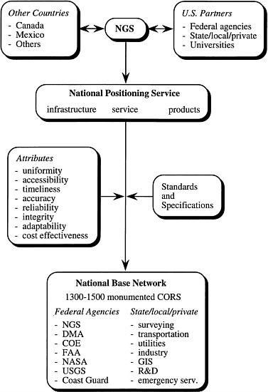
NOAA should establish a National Positioning Service (NPS) to implement the NSRS. The working group considers the NSRS to be a physical network of stations that provide a positioning and navigation utility. A national spatial reference system, however, should provide products and services that meet the disparate needs of the user communities, as well as the network infrastructure. For example, providing a densification network in an earthquake-prone area for better emergency response is a service. By using the term National Positioning Service, NOAA better emphasizes the services aspects of the utility. The utility would operate within the NGS.
The NGS has two roles in the NPS (Fig. 1). First, the NGS must coordinate, through public-private partnerships and Memoranda of Understanding (MOU), the efforts of other interested parties. This not only includes U.S. federal, state and local agencies, industries, and universities, but also other countries such as Canada and Mexico2. As a part of the global economy, the NGS cannot afford to neglect opportunities overseas. Second, the NGS must provide standards and specifications to ensure that the NPS has the following attributes: consistency, accessibility, timeliness, accuracy, reliability, integrity, adaptability, and cost effectiveness. The base network itself need only consist of 1300-1500 monumented CORS stations to satisfy these attributes. It is not expected that the NGS alone establish and maintain the National Base Network, but it must ensure that the data meet its high standards.
-
NOAA should combine Strategic Goals 3, 4, 5, and 9 into a single goal to create a National Base Network. The division of the NSRS into a FBN, Cooperative Base Network (CBN), User Densification Network (UDN), and network of CORS is misleading. For example, the Implementation Plan implies that there are four separate networks, and that the CBN and UDN will be created after the FBN and CORS as needed. Yet, the FBN and CBN are being created simultaneously, and CORS will largely occupy sites in the FBN. Rather than divide the NSRS into several networks, NOAA should create a National Base Network with the following characteristics: (1) the continuation of the FBN (with particular attention given to increasing the vertical accuracies), (2) the rapid evolution
|
2 |
Subject to DOD restrictions |
-
networks, NOAA should create a National Base Network with the following characteristics: (1) the continuation of the FBN (with particular attention given to increasing the vertical accuracies), (2) the rapid evolution of the FBN to CORS, using existing stations wherever possible, and (3) the development, in cooperation with federal/state/local government, universities, and the private sector, of a densified network. This approach will create a more seamless network, reach the broader user community more rapidly, and be more cost effective.
-
NOAA should continue to include U.G. Geological Survey (USGS) and Corps of Engineers (COE) bench marks in the NAVD 88. Many surveying engineering and mapping communities have depended on USGS and COE bench marks for their vertical datum reference. By selectively including these bench marks into NAVD 88, NOAA could expand efficiently and economically into areas not presently covered by that datum. At the same time, more rapid completion of the datum would better serve agencies like FEMA that are beginning to specify NAVD 88 as the vertical datum to be used on specific projects. Finally, NOAA should provide technical guidance, data, and services to the user community to assist them in converting their vertical datums to NAVD 88 and "time-tagging" their heights. Such time-tagging is particularly important in areas of active crustal motion.
-
NOAA should combine Strategic Goals 10 and 12 to emphasize the transition to GPS technology. Goal 12 is a transition step to goal 10; together they provide vertical service and products with current technology and data while GPS height determination is being developed to a user acceptable standard. Before GPS-derived orthometric heights can be widely used, NOAA should develop models to more accurately determine the relationship between the geoid and the ellipsoid, and to better understand atmospheric/ionospheric effects on the GPS signal. NOAA must also lead the development of standards and specifications for orthometric GPS heights and make them available to the user community. As GPS becomes more widespread, the need for traditional bench marks will decline, although traditional, differential leveling methods will still be needed in some cases.
-
The NGS should continue to provide service and products for the State Plane Coordinate System (SPCS). The SPCS bridges the geodetic and land surveying communities and has legal status in many states. The scientific community, however, uses the International Terrestrial Reference Frame (ITRF), which is a dynamic system. These user communities may best be served by having both the SPCS and ITRF available, with their interrelationships known at specific times.