National Academies Press: OpenBook
« Previous: Appendix C: Workshop Agenda
Suggested Citation:"Appendix D: Example Prototypes." National Research Council. 1999. Distributed Geolibraries: Spatial Information Resources, Summary of a Workshop. Washington, DC: The National Academies Press. doi: 10.17226/9460.
×

Appendix D Example Prototypes

Detailed in this section is a sample of World Wide Web sites chosen to illustrate existing elements of the distributed geolibrary vision. Each is largely isolated from one another and falls short of the full vision. Taken together, the set illustrates both what is already possible and how far we still are from a distributed geolibrary.

Microsoft's Terraserver (www.terraserver.com)

Terraserver offers digital imagery (Figure D.1) from the Russian SPIN-2 satellites and digital orthorectified photographs (orthophotos) from the U.S. Geological Survey. The archive contains over 1 terabyte of information and can be queried by pointing, zooming, and panning on a basemap or by specifying place-names. No services are provided for finding or integrating other data based on place.
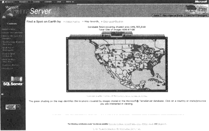
Figure D.1.

U.S. coverage in the terraserver database in October 1998.

Suggested Citation:"Appendix D: Example Prototypes." National Research Council. 1999. Distributed Geolibraries: Spatial Information Resources, Summary of a Workshop. Washington, DC: The National Academies Press. doi: 10.17226/9460.
×

MapQuest (www.mapquest.com)

The MapQuest site offers a range of services based on its database (see Figure D.2). The map illustrates the ability to provide services based on specific collections, in addition to serving unmodified information.
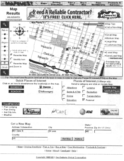
Figure D.2. 

Result of a request to the MapQuest site for a map centered on an address in St. Louis, Missouri.

Suggested Citation:"Appendix D: Example Prototypes." National Research Council. 1999. Distributed Geolibraries: Spatial Information Resources, Summary of a Workshop. Washington, DC: The National Academies Press. doi: 10.17226/9460.
×

Environmental Protection Agency ZIP Code Search (www.epa.gov/enviro/zipcodejs.html)

The U.S. Environmental Protection Agency's (EPA) web site offers several forms of place-based search through the agency's archives, including Maps On Demand and ZIP code search. From the web site:

The EPA Envirofacts Warehouse is a database that includes information on Superfund sites, drinking water, air pollution, toxic releases, hazardous waste, and water discharge permits. Through Envirofacts, you can get lists of which facilities in your neighborhood are releasing pollutants or are legally handling hazardous materials, where any Superfund sites are located and what their cleanup status is, and more. In many cases, you can link to more information about the chemicals involved at the listed sites, and find out whether they are potentially harmful.

Through Envirofacts' EnviroMapper feature, you can customize a computer-generated map of your neighborhood to view the location of EPA regulated sites, schools, churches, streams, streets, and other geographic features.

Suggested Citation:"Appendix D: Example Prototypes." National Research Council. 1999. Distributed Geolibraries: Spatial Information Resources, Summary of a Workshop. Washington, DC: The National Academies Press. doi: 10.17226/9460.
×

U.S. Bureau of the Census TIGER Map Server (tiger.census.gov)

The Bureau of the Census web site supports place-based search for census data. In Figure D.3 the TIGER Map Server has generated a map of part of Goleta, California, showing features selected by the user. The main purpose of the TIGER Map Service project is to provide a good-quality, national scale, street-level map to users of the World Wide Web. This service is freely accessible to the public, and based on an open architecture that allows other Web developers and publishers to use public domain maps generated by this service in their own applications and documents. We planned to provide high-quality street maps, with simple GIS capabilities such as point display and statistical choropleth mapping.

Figure D.3.

 The U.S. Bureau of the Census TIGER Map Server will create maps to user specifications, based on place-based search.

Suggested Citation:"Appendix D: Example Prototypes." National Research Council. 1999. Distributed Geolibraries: Spatial Information Resources, Summary of a Workshop. Washington, DC: The National Academies Press. doi: 10.17226/9460.
×

U.S. Geological Survey National Atlas (www.usgs.gov/atlas)

The National Atlas web site creates and delivers maps on demand from the National Atlas database. Figure D.4 shows the initial stage of specification.
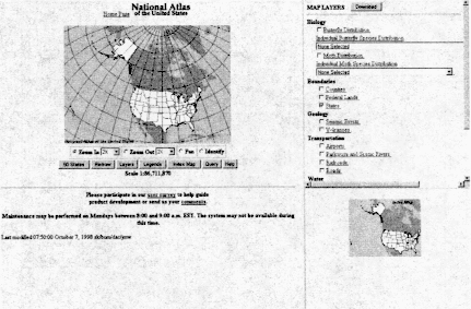
Figure D.4.

The U.S. Geological Survey's National Atlas web site, which allows  users to specify and create customized maps from the National Atlas database.

Suggested Citation:"Appendix D: Example Prototypes." National Research Council. 1999. Distributed Geolibraries: Spatial Information Resources, Summary of a Workshop. Washington, DC: The National Academies Press. doi: 10.17226/9460.
×

MIT's Digital Orthophoto Server (ortho.mit.edu)

This Massachusetts Institute of Technology web site serves digital orthophotos (DOQs) for the area around Boston. Figure D.5 shows the index page; by clicking on a tile it is possible to retrieve the associated data at a user-defined level of resolution.
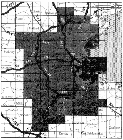
FIGURE D.5.

Index page for MIT's Digital Orthophoto server, which  provides downloadable orthophotography for the Boston area.

Suggested Citation:"Appendix D: Example Prototypes." National Research Council. 1999. Distributed Geolibraries: Spatial Information Resources, Summary of a Workshop. Washington, DC: The National Academies Press. doi: 10.17226/9460.
×

Alexandria Digital Library (alexandria.ucsb.edu)

The Alexandria Digital Library (ADL) is the product of a research project at the University of California, Santa Barbara, funded through the Digital Library Initiative of the National Science Foundation, the National Aeronautics and Space Administration, and the Defense Advanced Research Projects Agency. Figure D.6 shows the first screen in ADL's process of defining a place-based search. Additional properties can be specified to narrow the search, which is then applied to the order 106 data sets in the current ADL collection.
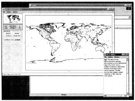
Figure D.6.

Opening screen of the Alexandria Digital Library's  Java-based engine for searching its collection based on location.

Suggested Citation:"Appendix D: Example Prototypes." National Research Council. 1999. Distributed Geolibraries: Spatial Information Resources, Summary of a Workshop. Washington, DC: The National Academies Press. doi: 10.17226/9460.
×

Microsoft's HomeAdvisor (www.homeadvisor.com)

This Microsoft web site is designed to help people searching for homes. It includes the ability to access demographic and other information about neighborhoods (see Chapter 1), search listings, and estimate payments. Figure D.7 shows the opening screen.

Figure D.7.

Microsoft's HomeAdvisor web site.

Suggested Citation:"Appendix D: Example Prototypes." National Research Council. 1999. Distributed Geolibraries: Spatial Information Resources, Summary of a Workshop. Washington, DC: The National Academies Press. doi: 10.17226/9460.
×
Page 109
Suggested Citation:"Appendix D: Example Prototypes." National Research Council. 1999. Distributed Geolibraries: Spatial Information Resources, Summary of a Workshop. Washington, DC: The National Academies Press. doi: 10.17226/9460.
×
Page 110
Suggested Citation:"Appendix D: Example Prototypes." National Research Council. 1999. Distributed Geolibraries: Spatial Information Resources, Summary of a Workshop. Washington, DC: The National Academies Press. doi: 10.17226/9460.
×
Page 111
Suggested Citation:"Appendix D: Example Prototypes." National Research Council. 1999. Distributed Geolibraries: Spatial Information Resources, Summary of a Workshop. Washington, DC: The National Academies Press. doi: 10.17226/9460.
×
Page 112
Suggested Citation:"Appendix D: Example Prototypes." National Research Council. 1999. Distributed Geolibraries: Spatial Information Resources, Summary of a Workshop. Washington, DC: The National Academies Press. doi: 10.17226/9460.
×
Page 113
Suggested Citation:"Appendix D: Example Prototypes." National Research Council. 1999. Distributed Geolibraries: Spatial Information Resources, Summary of a Workshop. Washington, DC: The National Academies Press. doi: 10.17226/9460.
×
Page 114
Suggested Citation:"Appendix D: Example Prototypes." National Research Council. 1999. Distributed Geolibraries: Spatial Information Resources, Summary of a Workshop. Washington, DC: The National Academies Press. doi: 10.17226/9460.
×
Page 115
Suggested Citation:"Appendix D: Example Prototypes." National Research Council. 1999. Distributed Geolibraries: Spatial Information Resources, Summary of a Workshop. Washington, DC: The National Academies Press. doi: 10.17226/9460.
×
Page 116
Next: Appendix E: Biographical Sketches of Panel Members »
Distributed Geolibraries: Spatial Information Resources, Summary of a Workshop Get This Book
×
 Distributed Geolibraries: Spatial Information Resources, Summary of a Workshop
Buy Paperback | $50.00 Buy Ebook | $40.99
MyNAP members save 10% online.
Login or Register to save!
Download Free PDF

A distributed geolibrary is a vision for the future. It would permit users to quickly and easily obtain all existing information available about a place that is relevant to a defined need. It is modeled on the operations of a traditional library, updated to a digital networked world, and focused on something that has never been possible in the traditional library: the supply of information in response to a geographically defined need. It would integrate the resources of the Internet and the World Wide Web into a simple mechanism for searching and retrieving information relevant to a wide range of problems, including natural disasters, emergencies, community planning, and environmental quality. A geolibrary is a digital library filled with geoinformation-information associated with a distinct area or footprint on the Earth's surface-and for which the primary search mechanism is place. A geolibrary is distributed if its users, services, metadata, and information assets can be integrated among many distinct locations.

This report presents the findings of the Workshop on Distributed Geolibraries: Spatial Information Resources, convened by the Mapping Science Committee of the National Research Council in June 1998. The report is a vision for distributed geolibraries, not a blueprint. Developing a distributed geolibrary involves a series of technical challenges as well as institutional and social issues, which are addressed relative to the vision.

READ FREE ONLINE

  1. ×

    Welcome to OpenBook!

    You're looking at OpenBook, NAP.edu's online reading room since 1999. Based on feedback from you, our users, we've made some improvements that make it easier than ever to read thousands of publications on our website.

    Do you want to take a quick tour of the OpenBook's features?

    No Thanks Take a Tour »
  2. ×

    Show this book's table of contents, where you can jump to any chapter by name.

    « Back Next »
  3. ×

    ...or use these buttons to go back to the previous chapter or skip to the next one.

    « Back Next »
  4. ×

    Jump up to the previous page or down to the next one. Also, you can type in a page number and press Enter to go directly to that page in the book.

    « Back Next »
  5. ×

    Switch between the Original Pages, where you can read the report as it appeared in print, and Text Pages for the web version, where you can highlight and search the text.

    « Back Next »
  6. ×

    To search the entire text of this book, type in your search term here and press Enter.

    « Back Next »
  7. ×

    Share a link to this book page on your preferred social network or via email.

    « Back Next »
  8. ×

    View our suggested citation for this chapter.

    « Back Next »
  9. ×

    Ready to take your reading offline? Click here to buy this book in print or download it as a free PDF, if available.

    « Back Next »
Stay Connected!