
2
A Vision for Distributed Geolibraries
Recent Developments
The past two decades have seen rapid developments in information technology. Hardware components have become smaller and more powerful, enabling the development of the personal computer and bringing the ability to process information to field environments that are far removed from the office and desktop. Software has grown more sophisticated, empowering individuals with little technical training to make effective use of computers in ways that would have been inconceivable 25 years ago. Developments in wireless communications allow networked access virtually anywhere. Most recently, applications of the Internet and World Wide Web (WWW) have captured the popular imagination and spawned entire industries of electronic commerce and information dissemination.
These developments have in turn driven massive changes in the way society disseminates and accesses information of various types. The role that information plays in everyday activities is changing, as people come to rely on access to up-to-the-minute information on weather, markets, politics, and entertainment via the Internet. Changes seem especially challenging and profound in the area of information that is tied or related to a geographic place, that is, a location at or near the surface of the Earth. Millions of people access such WWW sites as MapQuest (www.mapquest.com) or Microsoft's Terraserver
(www.terraserver.com) each day, which offer maps, driving directions, satellite images, and other forms of raw or processed information and related services (see Appendix D for examples). Similar changes are reflected in the proliferation of geospatial data clearinghouses, digital spatial data libraries, geographic information system software, and new high-resolution imaging satellites.
Several factors help explain the high level of interest in the Internet and WWW as technologies for disseminating these particular types of information and related services. First, the methods of storage and dissemination of traditional products—paper maps, atlases, and photographic images—are cumbersome in comparison to digital data products and often require special cabinets and awkwardly shaped shipping packages. Digital methods make it as easy to store or send a map as it is to handle text. Second, geoinformation is often related to a specialized interest, and it may be hard to justify maintaining an extensive collection in a local library or bookstore; the WWW is ideally suited to the distribution of such information in response to specialized needs because the costs of maintaining a server are low, and universal access to the Internet means that only one server is needed. Finally, geoinformation needs to be timely, but it can take years for a paper map to be produced, printed, and disseminated; the WWW allows users to access information as soon as it is posted.
At the same time there are potential disadvantages to use of the WWW as a mechanism for storing and disseminating geoinformation that will have to be addressed. Little of the information now available via the WWW has been subjected to the mechanisms that ensure quality in traditional publication and library acquisition: peer review, editing, and proofreading. There are no WWW equivalents of the library's collection specialists who monitor library content. But it is easy to be misled into believing that quality control problems of the WWW and distributed geolibraries are somehow different from conventional ones. Users of distributed geolibraries will tend to trust data that come from
reputable institutions, with documented assurances of quality, and to mistrust data of uncertain origins, just as they do today.
A common theme in all of these efforts to exploit the Internet and the WWW has been the enabling role of technology; many people with an interest in geoinformation and an awareness of the potential of the WWW and related technologies like the Java programming language have begun exploring their use. Five years after the first explosion of interest in the WWW is an appropriate time to pause and ask some basic questions:
- Is there a vision that drives the efforts to build clearinghouses and other WWW-based access and dissemination mechanisms for geoinformation?
- What need are these efforts satisfying, from the perspectives of the users and producers of geoinformation and the providers of related services?
- What problems impede progress, and on what problems should efforts be expended?
- What high-priority research needs exist?
- How should public resources best be expended, and what new forms of collaboration are needed?
The Mapping Science Committee convened a workshop1 in June 1998 to explore these issues. The Workshop on Distributed Geolibraries: Spatial Information Resources was designed to explore long-term visions of how ongoing activities may evolve, to explore possible development strategies, and to identify common needs (see Finding 2). Workshop participants were selected to represent a number of communities with interests in these issues:
experts in dissemination of geoinformation; leaders of current activities; specialists in the relevant technologies; and specialists in the associated institutional, legal, social, and economic issues. A list of participants is provided in Appendix A.
|
Finding 2 Although many projects currently exhibit elements of the vision of distributed geolibraries, the lack of a clear statement of that vision impedes coordination and leads to duplication of effort. A clear statement can provide a sense of common purpose. |
Prior to the workshop, participants were asked to contribute a "white paper" on issues they found relevant to the topic. These papers, which provided useful background to the meeting, are listed in Appendix B and are available on the WWW.
This report was prepared by the panel that organized the workshop (a list of panel members appears in the beginning of this report). Thus, it reflects the consensus of the panel, regarding the discussions that took place at the workshop, the issues that arose there and in the white papers, and the workshop's broader context.
The workshop did not attempt to bound the scope of distributed geolibraries precisely, and even if that were possible it would have been unreasonable to expect it in a workshop of such limited duration. Many basic questions remain unanswered, and this report should be read as a first effort in this area and as a stimulus for further work and discussion, rather than as a precise blueprint.
The workshop participants were almost entirely from the United States, and this report necessarily adopts a U.S. perspective. Nevertheless it is hoped that it will be read by non-U.S. researchers and developers interested in distributed geolibraries and that it will help to achieve a greater degree of convergence in research and development at the international level.
A Library Vision
The organizers of the workshop chose to frame the discussion by reference to the functions, services, and institutional arrangements of the library, for two major reasons: first, to engage the library community, with its long experience in providing access to information, in the development of a vision for a new kind of library and, second, to provide a familiar and concrete starting point for the discussion. It is possible that libraries will be the principal means whereby citizens gain access to the services of the distributed geolibraries of the future; it is also possible that libraries will play no significant part in that process.
The metaphor of the library is powerful because it immediately suggests a number of important issues. For example, one way to think of a library is as a storehouse of the intellectual works of society, and millions of people from all walks of life have contributed works to our current library system. Can we expect to see a similar diversity of contributors in the distributed geolibraries of our future? What incentives are needed to motivate people to make their works accessible? If a library exists to serve a community, its first responsibility should be to provide the information needed by the community. How important is geospatial information about the community itself, produced perhaps within the community, compared to information about areas outside the community perhaps produced by others? Will a local geolibrary, responsible to a local community, acquire and make available very different works and databases than a university-based geolibrary, state geolibrary, federal agency geolibrary, or a private geolibrary?
There are many types of libraries and much variation in the functions they perform. Some of the comments in this report refer to all types of libraries, and some are more appropriate for the research library, the institution maintained by a university, or similar organization for the use of its community of scholars. In general, it is the research library that provides the model of services discussed in this report.
However, the metaphor of the library should not be taken too far, and not all aspects of the operation of a library will be useful in envisioning distributed geolibraries. Many of these will be generic and of no specific relevance to the geoinformation that is the focus of distributed geolibraries. Such issues have already been discussed at length in the library and digital library literatures, and no attempt is made to replicate those discussions here. For example, it is assumed that distributed geolibraries will need to address issues of archiving and preservation (particularly serious issues given the rate of technological change in the digital world), but these are generic to all libraries and are not discussed at length in this report.
Defining a Distributed Geolibrary
Three ideas help to define the concept of a distributed geolibrary: it is distributed, modeled on the concept of a library, and concerned with information about the Earth. The next three sections discuss these ideas in detail and build an outline of a vision for distributed geolibraries.
A Distributed Library
The term distributed refers to the locations of the physical and functional parts of the library and the locations of its users. In a traditional library the various stages of putting useful information into the hands of users occur largely in one place, in the physical structure known as the library. Books arrive in an acquisitions department; they are cataloged by specialists employed by the library in a cataloging department, placed on shelves within the library in locations designed to make it easy for patrons to browse through holdings on similar topics, retrieved by librarians and users, and signed out of the library at the circulation desk operated by a circulation department. Because these functions occur in one institution, it is sometimes difficult for an observer to separate
them and difficult to distinguish the functions of the library from its physical assets.
In today's digital world it is possible for functions to occur in multiple locations, held together and coordinated by communications networks like the Internet. Catalog staff may work in locations far removed from the reference librarians who eventually use the catalog to help users find the information they need. Moreover, today's technology is advancing to the point where patrons (or users) can employ library services to combine data sets located in different places. For many purposes the Internet provides almost infinite connectivity, such that a user may conceive of a single database that is in reality distributed over many different servers under different jurisdictions. Users have the option of processing data on their own computers or sending data to remote locations where processing capabilities are more powerful. Wireless technologies provide for communication to virtually everywhere, and computing technology can now be packaged into electronic units that are readily transportable and in some cases wearable.
Libraries have responded to this new networked environment by establishing coordinated, collaborative, and multi-institutional relationships. The library building no longer houses all of the services it provides to its users; instead, the institution of the library obtains those services in whatever ways maximize effectiveness and minimize costs, by using resources in the building or from a myriad of sites distributed around the globe.
Traditionally, libraries have made a clear distinction between general and special collections, using the latter term to refer to assets that need special treatment or that are unique in some way to a particular library, such as the papers of a particular literary or scientific figure. Maps and images form special collections in many libraries, in part because they are difficult to handle and in part because much of the collection may be unique. The transition to a digital world will mean that many of the difficulties of handling special media disappear, allowing such collections to become part of a library's information mainstream
(although working with maps and images will always demand specially designed interfaces and large monitors because of their visual content and broad bandwidth and powerful processors to deal with voluminous data). But the uniqueness of the special collection will become increasingly important in the digital world, in which any item in any collection is potentially accessible from anywhere.
In this report the term custodian refers to the person or agency responsible for maintenance of a given data set. The custodian may be far removed from the server on which the data set is mounted and from which it is disseminated, but nevertheless it is the custodian who holds the definitive version of the data and updates it to account for changes. The custodian may have some form of responsibility for quality—for example, the custodian may decide which data are to be acquired and held based in part on quality or may provide assurances of quality to users. The function of a custodian is different from that of a repository or archive, which is where data are preserved in static form.
Geoinformation
Geoinformation is information that is specific to some part of the Earth's surface or near surface. It includes maps, of course, which abstract and present information about the locations of phenomena on the surface; it also includes images from the air or space (aerial photos or remotely sensed images) that capture the appearance of the surface using energy (either visible or invisible) radiated from it in some part of the electromagnetic spectrum. Such data were earlier defined as geospatial. In addition, geoinformation includes the contents of guidebooks, reports on specific areas, data sets with a geographic dimension, and any other information assets that serve to differentiate one geographic area from another. Finally, it includes information about the atmosphere above the surface, the geology below the surface, and the oceans that cover two-thirds of the planet's surface.
All of these information assets are characterized by having some form of associated geographic footprint, a boundary defining
the geographic extent of the information, which is the defining characteristic of geoinformation as the term is used here. A map sheet has a footprint defined by its edges, whereas a guidebook to Moscow has a footprint of the city limits (or the city and the surrounding region). A photograph might have a footprint, defined as the area shown in the photograph; a piece of music (George Gershwin's "An American in Paris," for example) might also be associated with some particular location on the Earth's surface. Moreover, the footprint provides a useful way of finding information. Just as author, subject, and title are ways of finding information assets in a traditional library, so the footprint of geoinformation gives the library the ability to identify all those assets that fit a given geographic query. For example, if information assets in the library had a footprint, it would be possible to identify those assets relevant to a user wanting information on the state of Missouri, or the Caspian Sea, by determining whether the footprint of the asset matched the footprint of the query in whole or in part. It would be possible to ask the library to provide all available information about a given place that is relevant to a defined need, in other words "everything relevant about there."
While the space of a search based on author or subject is discrete, geographic space is continuous and multidimensional, and there is no limit to the number of distinct, unique footprints that exist. Any degree of overlap is possible between a footprint and a query, making search by place inherently more complex than search by other keys. Geographic location is sometimes recorded in the subject fields of library catalogs (for example, the Melvyl catalog of the University of California library system includes a place-related subject in about 30 percent of all records), and it is included in the Dublin Core standard (purl.org/dc). But distributed geolibraries would prioritize place as the primary key and thus would require that footprints be explicit in all cases.
Two distinct methods are available for specification of footprints. An area of interest may correspond to one or more place names, or recognized terms for describing location. Alternatively, the area may be defined by one or more bounding
coordinates, in some recognized system such as latitude and longitude. To be compatible, the two methods require the services of a gazetteer, or an index that relates named places to coordinates. Gazetteers are commonly used to index atlases, though as the name suggests they typically include only places whose names have some level of official recognition.
The issues surrounding place as a search key are to some extent similar to those surrounding time, or date. All of the examples in Chapter 1 require search by place, in many cases qualified by relevant intervals or points in time; perhaps it is possible to devise parallel examples that would require search by time, possibly qualified by place, to motivate the development of chronolibraries. Similarly, an important but less compelling case can be made for a three-dimensional approach to space, based on examples of data that relate to points substantially above or below the Earth's surface.
Spatial keys are not unique to geoinformation, and there are parallels to other domains that may be useful and informative in the development of distributed geolibraries. For example, the Hytime hypermedia document structuring language (Newcombe et al., 1991) includes standards for specification of spatial windows in arbitrary coordinate systems within documents.
Geoinformation can be cumbersome for the traditional library because it comes in many forms, on different media, and because there is no simple basis for cataloging it. Instead, map libraries and other stores of geoinformation have had to maintain expensive and highly trained staffs to help users navigate through their information resources, and users have had to look to numerous sources to meet their geoinformation needs. Users of geoinformation were often highly trained experts, knowledgeable about sources, data quality, acronyms, and other tools of the geoinformation trade. In short, there has been no way for an average person to address a library with the query "tell me everything you have about that place that is relevant to me." Yet such queries are common and immensely important to a wide
range of human activities, as the examples in the opening chapter illustrate.
Although it is helpful to think of a distributed geolibrary as a container of the digital equivalent of maps, that metaphor may also be unduly limiting. Geoinformation is not restricted to information that is static, or two-dimensional, but includes information on the dynamic processes and changes happening at a place, and three-dimensional data about the atmosphere and subsurface. But as noted earlier, the two horizontal dimensions are most likely to be the basis for search, possibly refined by time and the vertical dimension.
Characteristics of a Distributed Geolibrary
One way to think about a geolibrary (in a world of paper documents) is to imagine walking into a library building and being confronted not with a card catalog, or its modern digital equivalent, but with a giant physical globe. Suppose what is needed is information about a particular part of Patagonia, the southern extremity of Argentina, for a project on Charles Darwin, who visited Patagonia, or on the people of Welsh descent who live there, or on the works of author Bruce Chatwin, who wrote about his travels there. The library user finds Patagonia on the globe, points to it, and asks a nearby librarian about the relevant assets of the library. Some minutes later the librarian produces a list of those assets, with enough information to allow the user to evaluate their importance to the project. After the user narrows the list, the librarian disappears again, to return with the requested holdings.
Several aspects of this concept ensure that it has remained in the realms of fiction for as long as libraries have existed. Some aspects are technological. There is no way to build a physical globe that can be repositioned at will or magnified on demand to display greater and greater detail. Zooming would need to be possible over several orders of magnitude; a large globe might reasonably be expected to show features on the Earth's surface that are 10 km in size, including large lakes and large cities, but not features as small as a neighborhood; but the user of a geolibrary
might well want to consider a single city block, which requires a resolution finer than 10 m, or a factor of 1,000 finer than the initial coarse view. Such resolutions are increasingly common in geospatial data.
In addition to resolution, a physical geolibrary would be difficult to build because many of its users would not be able to find their areas of interest on the globe. Not every user would be able to reposition and zoom to identify his or her own neighborhood, without the assistance of an expert. There are not enough resources to support the necessary expert librarians and no way to transform automatically a specified location into a list of assets. Finally, there is no way to shelve the many different types of information so that they can be easily retrieved and so that two sources of information on similar topics or areas are located near each other in the library. In other words, a physical geolibrary cannot be built.
In a digital world, however, all of these objections disappear, apparently without exception. It is possible to present the digital library user with a picture of a globe; search for locations by name, address, or any other suitable and convenient method; allow repositioning and zooming; search distributed archives for information assets whose footprints match the query, present them to the user in sufficient detail to permit evaluation; and deliver them for further examination and analysis. But although a geolibrary is possible in principle, there are countless technical, practical, economic, and institutional problems that will have to be overcome. Moreover, it is unclear how a geolibrary would deal with issues of intellectual property and how it could be paid for and whether the costs would be outweighed by the benefits. These issues are explored in greater detail in Chapter 3.
A distributed geolibrary would provide a much more sophisticated and powerful layer of services above the Internet and the WWW (Figure 2.1). The Internet provides the means of communication between computers, using the TCP/IP standard. The WWW is supported by the Internet, providing services that allow any user to access information provided by any server. But
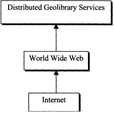
Figure 2.1.
Distributed geolibraries as a third layer of services above the WWW and the Internet.
the combination of the two technologies falls far short of the services of a distributed geolibrary:
- The WWW does not have an equivalent of the library's carefully constructed catalog of assets. Search services such as AltaVista, Yahoo, and eBLAST that substitute for the services of a WWW catalog are crude imitations of the sophisticated skills of information abstraction possessed by the professional librarian.
- The number of WWW servers is now on the order of 107 and increasing rapidly. Even the most powerful of today's search engines can access no more than one-third of what is currently available, and this proportion decreases daily (National Public Radio report dated 3 April 1998 in a recent article in Science).
- Footprints and other essential information are not normally present in WWW information resources, and there are limited tools to look for them or to determine them automatically. Chapter 4 of this report discusses existing efforts to develop some of these services, and Appendix D includes examples of current projects
- Users must rely on personal knowledge to find sites that contain needed information assets and must learn the specific protocols used by each site.
- There are no generally available services for combining information from multiple sources or for support of analysis, visualization, and interpretation of geoinformation by the user, although such services have been developed in limited contexts, including U.S. Department of Defense applications.
and sites that offer some of the services of distributed libraries, such as the University of California's Alexandria Digital Library.
In other words, a distributed geolibrary would constitute a level of services above those provided by the Internet and the WWW, geared to specific user needs. Distributed geolibrary services offer the potential for more intelligent organization and access, for the creation of new knowledge through analysis of raw data, and for the solution of practical problems. As such, distributed geolibraries are one of a number of new types of Internet services that exploit previously impractical ways of organizing and presenting information.
Distributed Geolibraries and the National Spatial Data Infrastructure
"The National Spatial Data Infrastructure is the means to assemble geographic information2 that describes the arrangement and attributes of features and phenomena on the Earth. The infrastructure includes the materials, technology, and people necessary to acquire, process, store, and distribute such information to meet a wide variety of needs" (National Research Council, 1993, p. 2, emphasis added). The concept emerged in the
|
2 |
The term geographic information here is synonymous with geospatial data as defined in Chapter 1. But as noted earlier in this chapter, many additional types of information qualify as geoinformation by virtue of having a geographic footprint. |
early 1990s in response to a number of potentially critical trends that were affecting the nation's supply of geospatial information and related services and institutions:
- Budgets in the federal public sector were declining and were no longer able to meet the nation's growing needs for high-quality, current geospatial data at minimal cost to users.
- Improved and cheaper mapping technology was empowering local and state governments to produce their own geospatial data to meet local needs and stimulating a growing private-sector industry.
- Advances in digital technology were making it possible to integrate and analyze geospatial data and support decisions in more powerful ways.
The Mapping Science Committee's report Toward a Coordinated Spatial Data Infrastructure for the Nation (National Research Council, 1993) and the efforts of many other individuals and agencies led in 1994 to Executive Order 12906, by which President Clinton ordered the development of the National Spatial Data Infrastructure (NSDI). Since then, several other committee reports and extensive efforts by the Federal Geographic Data Committee (FGDC), National States Geographic Information Council (NSGIC), National Association of Counties (NACO), and other groups have refined the concept of the NSDI and demonstrated its power and effectiveness (Tosta and Domaratz, 1997; Moeller, 1998; Rhind, 1999).
|
Finding 3 The contents of a distributed geolibrary are not limited to information normally associated with maps or images of the Earth's surface but include any information that can be associated with a geographic location. In this sense the vision extends far beyond the context of the NSDI. |
When the NSDI was defined in 1993, few users or producers of geospatial data made much use of the Internet, and
the WWW was virtually unknown; the first popular browser, Mosaic, was released by the National Center for Supercomputer Applications early that year. Although there was much emphasis on digital geospatial data, the primary method of dissemination was by magnetic tape; there were virtually no digital online catalogs of geospatial data and no methods for searching for data across computer networks. Moreover, since most useful geospatial data were produced by a small number of federal agencies, there was little problem locating the appropriate source. WAIS (Wide Area Information Service) was the first of several network-based technologies that rapidly changed the nature of geospatial data dissemination over the next few years. Today, applications on the WWW have grown into an enormously successful tool, and have had a profound impact on the entire environment for geoinformation acquisition (National Academy of Public Administration, 1998). At the same time, the WWW has presented a growing problem in its inability to deal effectively with the problems of discovering what geoinformation exists and locating an appropriate source, as the number of potential suppliers has mushroomed.
|
Finding 4 The vision of the NSDI as expressed by the Mapping Science Committee in 1993 (National Research Council, 1993) did not anticipate the enormous impact and potential of the Internet and WWW. By emphasizing the problems of production of digital geoinformation, it underemphasized the importance of effective processes of dissemination to users of geoinformation. User communities are growing rapidly and are likely to grow even more rapidly if the current difficulties associated with finding geoinformation on the Internet can be addressed. |
This report and related efforts in general can be understood therefore as an updating of the Mapping Science Committee's concept of the NSDI in the era of the WWW. In organizing this effort and producing this report, the committee is expressing its
view that the WWW has added a new and radically different dimension to its earlier conception of the NSDI, one that is much more user oriented, much more effective in maximizing the value of the nation's geoinformation assets, and much more cost effective as a data dissemination mechanism. Distributed geolibraries reflect the same basic thinking about the future of geospatial data, with its emphases on sharing, universal access, and productivity but in the context of a technology that was not widely accessible prior to 1993.
|
Finding 5 Distributed geolibraries provide a useful framework for discussion of the issues of dissemination associated with the NSDI. The vision is readily extendible to a global context. |
The NSDI fits well with the description of infrastructure provided by Star and Ruhleder (1996, pp. 111-112):
"It is both engine and barrier for change; both customizable and rigid; both inside and outside organizational practices. It is product and process. . . . With the rise of decentralized technologies used across wide geographical distance, both the need for common standards and the need for situated, tailorable and flexible technologies grow stronger."
Their defining dimensions of infrastructure provide useful guidance to the development of distributed geolibraries: they would be embedded in other structures, social arrangements, and technologies; their reach or scope would extend beyond a single site or practice; their procedures would be learned as part of membership of an organization or group; they would be linked with conventions or practice of day-to-day work; they would be the embodiment of standards and would build upon an installed base; and they would be visible on breakdown, since we would be most aware of them when they failed to work.
Distributed Geolibraries and Digital Earth
Distributed geolibraries bear a strong resemblance to certain aspects of the concept of Digital Earth, a concept that was defined by Vice President Gore in January 1998 and summarized in a speech given in Los Angeles. The vision is aptly summarized in the following extract:
"Imagine, for example, a young child going to a Digital Earth exhibit at a local museum. After donning a head-mounted display, she sees Earth as it appears from space. Using a data glove, she zooms in, using higher and higher levels of resolution, to see continents, then regions, countries, cities, and finally individual houses, trees, and other natural and man-made objects. Having found an area of the planet she is interested in exploring, she takes the equivalent of a 'magic carpet ride' through a 3-D visualization of the terrain. Of course, terrain is only one of the numerous kinds of data with which she can interact. Using the system's voice recognition capabilities, she is able to request information on land cover, distribution of plant and animal species, real-time weather, roads, political boundaries, and population. She can also visualize the environmental information that she and other students all over the world have collected as part of the GLOBE project. This information can be seamlessly fused with the digital map or terrain data. She can get more information on many of the objects she sees by using her data glove to click on a hyperlink. To prepare for her family's vacation to Yellowstone National Park, for example, she plans the perfect hike to the geysers, bison, and bighorn sheep that she has just read about. In fact, she can follow the trail visually from start to finish before she ever leaves the museum in her hometown.
She is not limited to moving through space, but can also travel through time. After taking a virtual field-trip to Paris to visit the Louvre, she moves backward in time to learn about French history, perusing digitized maps overlaid on the surface of the Digital Earth, newsreel footage, oral history, newspapers and other primary sources. She sends some of this information to her personal e-mail address to study later. The time-line, which stretches off in the distance, can be set for days, years, centuries, or even geological epochs, for those occasions when she wants to learn more about dinosaurs.''
Digital Earth is also the title of a project3 of several years' standing at NASA's Goddard Space Flight Center, which also contains elements of the Vice President's vision. It is also associated with a plan to place a satellite (tentatively named "Triana") between the Earth and the Sun to deliver real-time images of the sunlit Earth to a global audience.
Like distributed geolibraries, Digital Earth is about making use of the vast but uncoordinated masses of geoinformation now becoming available via the Internet and about presenting it in a form that is readily accessible to the general user. Like distributed geolibraries, its central metaphor for the organization of information is the surface of the Earth and place as a key to information access. In a similar vein the U.S. Geological Survey is exploring the Earth's surface as the organizing metaphor for public access to its data resources, and similar ideas are surfacing in other agencies (see Appendix D).
Learning about places on the Earth is a strong theme in Vice President Gore's vision for Digital Earth and a strong motivation for distributed geolibraries. While the prevailing metaphor for human-computer interaction is the office or desktop, that metaphor may not be particularly helpful in organizing information about the Earth. Instead, access to a distributed geolibrary could be through the visual metaphor of the Earth's surface itself; a student
interested in Thailand would manipulate a globe on screen until it centers on Thailand and then zoom in for more detail, as in the Digital Earth vision. Distributed geolibraries might make a useful contribution to the educational opportunities of digital libraries, as outlined, for example, in previous reports on digital libraries for science, mathematics, engineering, and technical education (see Corporation for National Research Initiatives, 1998; National Research Council, 1998).
The library service model that underlies the concept of distributed geolibraries provides a useful way of structuring discussion and of thinking about the resources and research that will be needed to make the vision a reality. Chapter 3 discusses some of the societal and institutional challenges to realizing distributed geolibraries. Addressing many of these policy issues is crucial to creating a conducive atmosphere for considering the potential services and functions of distributed geolibraries (see Chapter 4) and the technical developments needed to build distributed geolibraries (see Chapter 5).


