
3
Technologies and Techniques
In this section, the current technologies and techniques for locating, tracking, containing, and recovering spills of nonfloating oils are summarized. The presentation is divided into subsections on spill modeling and information systems, spill tracking and mapping, and oil containment and recovery. The summary focuses on the current state of practice and identifies systems that have been applied or proposed for application to submerged oil. Summaries of the use of these techniques in selected spills in which substantial quantities of oil were submerged or deposited on the seabed can be found in Michel and Galt (1995) and Michel et al. (1995). An annotated bibliography of the literature can be found in NOAA (1997).
Modeling and Information Systems
The following discussion begins with a brief overview of the state of the art in spill modeling and information systems (Box 3-1). This is followed by the extension of spill models to include the subsurface transport and deposition of dispersed oil and a history of the use of these models to ''hindcast'' (analyze a past event) several large accidental spills in which subsurface transport was important. The use of models to forecast and hindcast spills involving substantial amounts of submerged oil is then summarized.
Recent comprehensive reviews of the state of the art in spill modeling (Spaulding, 1995; ASCE, 1996) show that the models have evolved quite rapidly taking advantage of the availability of low-cost, high-powered workstations and personal computers with full color graphics, extensive storage, and communications systems. A simultaneous evolution in the software has enabled a clear
|
BOX 3-1 Oil-Spill Model The core of an oil-spill model is a series of algorithms that represent the processes controlling the transport and fate of oil released into the environment. The transport portion of the models describes the physical movement of oil by winds, currents, waves, and associated turbulence, The fate of the oil is normally represented in terms of spreading, evaporation, dispersion or entrainment, dissolution, emulsification, biodegradation, sinking or sedimentation, photo-oxidation, and oil-shoreline and oil-ice Interactions. These processes are typically formulated Individually with links to other processes or environmental data as necessary to describe the oil's fate. The algorithms may be altered or changed entirely depending on the environment in which the oil is spilled or transported. Input to oil-spill models normally includes a description of the study area, the oil-spill scenario (spill location, release rate and schedule, and oil type), and environmental conditions. The study area is normally described using a map of the region of principal interest, The environmental forcing data typically consist of estimates of the temporally and spatially varying wind and current fields for the forecast period (typically a few days for spill-response support) and an estimate of the mean water temperature. These environmental data fields may be provided by supporting hydrodynamic and meteorological models for the study area or from observations. The model output typically includes animations of the movement of the surface oil and the oil mass balance by major environmental compartments (surface, water column, onshore, evaporated, seabed, biodegraded), the oil thickness and areal extent, and the oil properties (viscosity, water content) versus time. |
separation to be made between the model software and supporting environmental data (Spaulding and Chen, 1994). With model/data separation, the models can be rapidly applied to new locations (Anderson et al., 1993). Many models have been linked with geographic information systems (GISs) or have limited GIS functions embedded in the model systems (Galagan et al., 1992). With the incorporation of the GIS and other data management tools, users can input, organize, manipulate, archive, and display geo-referenced information relevant to spill modeling. With the extension of spill models to include supporting data management tools, spill information systems have been developed that can provide valuable data to support spill responses and planning.
In most cases, models have been tested and validated by application to selected, usually large, accidental spills or experimental field trials. These events are selected based on the availability and quality of data. Hindcasts of the largest, most recent spills (Exxon Valdez, the Gulf War spill, Braer, North Cape) have been used by several researchers to demonstrate the predictive performance of their models.
Basic spill models have been extended to include biological and, in some cases, economic models for estimating the impact and damages of spills (e.g., French et al., 1994). These models are now being incorporated into comprehensive, on-scene, command-and-control systems (Anderson et al., 1998). Strategies for using models to prepare a trajectory analysis have been developed by Galt (1994, 1995). The National Oceanic and Atmospheric Administration (NOAA) has also developed digital distribution standards for data on trajectories (Galt et al., 1996).
Most of the spill models developed to date focus on the transport and fate of surface oil slicks. These models typically predict the mass of oil removed from the sea surface by evaporation, by dispersion or entrainment into the water column, and by sinking and sedimentation but do not explicitly track the dispersed oil. This approach has been taken because most spills involve oils that float throughout most of the short-term spill response. Selected models have the capability of predicting the three-dimensional evolution of oil, including entrainment, subsurface transport, sedimentation, and refloating of spilled oil (e.g., Spaulding et al., 1994; Elliot, 1991; Johansen, 1985; French et al., 1994). The majority of these models employ a particle-based, random-walk technique to predict the evolution of subsurface oil (Kolluru et al., 1994) although other alternatives have also been investigated (Spaulding et al., 1992). In these models, the influence of oil sediment interaction (Kirstein et al., 1985) and the buoyancy of dispersed oil droplets are explicitly accounted for.
The use of the three-dimensional models to forecast and hindcast spills has been limited. Most simulations have been restricted to buoyant oils that have been dispersed in the water column by strong winds or wave forcing. Although these oils are not a direct analog for nonfloating oils, they are instructive in illustrating the ability to predict the transport and fate of oil dispersed in the water column. For example, both Proctor et al. (1994) and Spaulding et al. (1994) performed hindcasts of the Braer spill. Both models correctly predicted the general subsurface transport of the highly dispersible, Gulfaks crude oil that was spilled. The predicted location of the subsurface oil was consistent with the pattern of sedimented oil found on the seabed. Neither hindcast included oil-sediment interaction, however, and no predictions were made of the deposition of sedimented oil.
A review of the literature on oil beneath the water surface and Group V oils by NOAA (1997) shows that spill models have generally not been used to forecast or hindcast spills of heavy oils. This is consistent with the summaries of spills of heavy oils presented in Michel and Galt (1995) and Michel et al. (1995). The absence of model applications to forecast or hindcast these events can be attributed to several factors. First, spills of heavy oils are generally less frequent, and the volume of oil spilled tends to be less than in spills of floating oils. Second, requirements for current data (either from observations or hydrodynamic
model predictions), which are difficult to obtain for surface spills, are increased substantially when the subsurface transport of oil is involved. The subsurface current structure is of limited importance when the flows are principally tidal and water depths are shallow, but they become particularly important when stratification and multilayer flows are present. Finally, Michel and Galt (1995) have shown that substantial subsurface transport and deposition often occur as the result of the interaction of buoyant oil with sand. The sinking and subsequent deposition of oil caused by changes in the oil's density due to weathering (evaporative losses) or burning are rare (Lee et al., 1989, 1992).
Most spill models are focused on predicting the transport and fate of oil at sea and do not include oil-sediment interactions or oil-shoreline interactions. Given the lack of data and the lack of a clear understanding of the controlling processes, those that do are necessarily rudimentary (ASA, 1997; Reed et al., 1989). Incorporating oil-sediment interactions into spill models will require estimates of the suspended sediment concentrations as input (Kirstein et al., 1985). These estimates are normally based on observations or model predictions, and the data are rarely available during spill events. Incorporating oil-shoreline interactions will require extensive data on the nearshore environment, including geomorphology and wave and current fields. Once again these data are generally not available for most spills, particularly during the emergency response phase.
Given this situation, two strategies might be tried to use existing spill models to assist in the response to spills where subsurface transport processes and sinking and sedimentation might be important. First, the spill model could be used to explore the impact of various assumptions about the subsurface transport of the oil and the interaction of oil and sediment. For example, it could be assumed that a portion of the oil will be removed or leave the surface as it becomes neutrally buoyant or sinks at a specified rate due to oil-sediment interaction. Model predictions could then be made to estimate the path and a general sense of the area and volume that would be impacted by the subsurface oil. The information could be used to establish field sampling programs. Data collected from the field on the current structure and sediment concentrations could then be used to refine the predictions and narrow the scope of the uncertainty.
A second approach would be to place the spill model in real-time operation for the principal areas of concern. Supporting three-dimensional hydrodynamic and sediment-transport models for nearshore and offshore areas would provide currents and suspended-sediment fields for inputs to the spill model. The models, which would have been validated with field observations, would be able to assimilate real-time data from monitoring systems to maximize their predictive performance. This approach would only be viable for areas where the probability of spills is high enough to warrant the investment in the development, application, and maintenance of such a system.
Tracking and Mapping Techniques
Techniques for tracking and mapping the location of oil throughout a spill and subsequent cleanup are critical to the effective containment and recovery of oil in the water column or deposited on the seabed. A brief summary of current methods for tracking and mapping subsurface oil follows. The review is based primarily on summaries in Castle et al. (1995) and Michel et al. (1995). Additional information is available in Smedley and Belore (1991) and Brown et al. (1997). As a practical guide to determining which tracking and mapping options are most appropriate, Figure 3-1 provides a typical decision tree based on oil density and water depth. The first branching is based on assessing the density of oil relative to the density of the receiving water and includes two branches, one if the oil is neutrally buoyant and one if the oil is negatively buoyant in receiving water. The second branching depends on the water depth. Final selection of the tracking method is dependent on local conditions, the availability of equipment and personnel, and weather conditions.
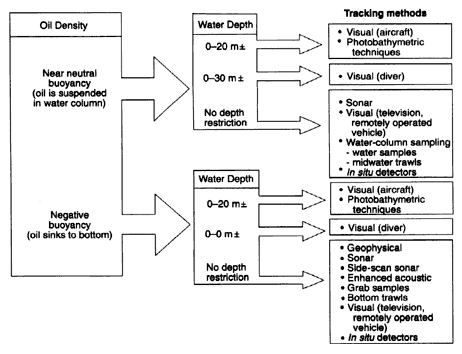
Figure 3-1
Decision tree based on oil density and water depth. Source: Castle et al., 1995.
Visual Observations
Visual observations (by aircraft, ship, diver, or camera/television) have been the principal methods of locating and tracking submerged oil. Airborne photography and visual-based systems, which are widely available and can rapidly survey large areas, are widely used to locate submerged oil. The performance of these systems is limited by water clarity and depth, the quantity of oil, and the characteristics of bottom sediment. Given the possibility of misidentifying natural materials (seaweed, seagrass beds) as oil, in situ observations are always required to validate airborne assessments. Direct observations can also be performed by divers within safe depth restrictions and visibility limits. Observations by underwater cameras, either operated by divers or deployed from ships, can also be used to locate submerged oil. These visual methods must generally be confirmed by sampling and have relatively limited coverage. As an extension of visual methods, photobathymetric techniques, such as multispectral photography, may be useful for mapping oil on the seabed in shallow water (Benggio, 1994b). Once again, field confirmation and calibration are required.
Remote Sensing Techniques
Standard, side-looking, airborne radar, synthetic-aperture radars, and infrared/ ultraviolet line scanners are generally unable to map subsurface oil because they cannot penetrate the water surface (Fingas and Brown, 1996). The methods are also hindered by the weather and visibility. Laser fluorosensor techniques have been developed and shown to be able to detect oil in the water column for the purposes of oil exploration (Dick and Fingas, 1992; Dick et al., 1992). Little evidence exists that this technique has been used in responding to spills of nonfloating oils, however (Brown et al., 1997). Recent laboratory experiments by Brown (1998) have demonstrated a laser airborne fluorosensor that can detect the presence of dispersed bitumen in the water. No field tests or practical uses of the system have been made to date.
Geophysical/Acoustic Techniques
These technologies include of a variety of acoustic-based techniques for locating and mapping submerged oil (Chivers et al., 1990). These techniques rely on acoustic sounding principles, specifically the differential density and sound speeds of water compared to those of oil or oil-sediment mixtures and the scattering of sound waves from particulate material in the water column. Oil in the water column can be qualitatively mapped by commercial fish-finding and echo sounders or by precision survey equipment. Oil on the seabed and associated bottom features can be mapped by side-scan sonar systems. The output of these systems can be enhanced for mapping the texture and composition of the bottom.
One such system was reportedly used to map the submerged oil from the Morris J. Berman and Haven spills (Marine Microsystems, 1992).
Side-scan sonar mapping systems are normally interfaced with the global positioning system (GPS) and hydrographic mapping software to generate maps of seafloor features. These systems can provide relatively rapid coverage but are most useful when they are used to direct the surveys for areas of natural collection that have already been identified. These specialized systems may be unable to distinguish between oiled sediments and underlying sediments because of their acoustic similarity. Therefore, sampling or in situ observations are necessary to confirm the maps.
Water-Column and Bottom Sampling
Direct sampling of the water column or seabed may be used to locate and map the movement of oil. Sampling can be done by a vessel, a remote vehicle, or a diver (in shallow water). Sampling generally becomes more difficult and time consuming as the water depth, current speed, and wave height increase. A variety of sampling techniques are available, including grab sampling of water or sediments with subsequent visual or chemical analysis, sorbent materials deployed on weighted lines or in traps (Benggio, 1994a), and core sampling of the seabed sediments. Sampling is typically limited in scope and may not provide representative observations of the impact area. Water-column and bottom trawls may be useful for selected spills because they can cover larger areas. The effectiveness of sampling methods is strongly dependent on the composition of the oil and oiled sediment and environmental factors, such as current speed, water depth, and substrate type.
In Situ Detectors
In situ and towed fluorometric detection are widely available and routinely used to detect and map petroleum leaks and spills (Turner Designs, 1999). These systems may be mounted on buoys, boats, or remotely operated vehicles. When mounted on boats and coordinated with GPS, they can provide maps of the subsurface oil concentration field. They are restricted to making oil concentration measurements in the water column (Brown et al., 1997) and have a detection range from parts per billion to parts per million, depending on environmental conditions and oil type. Given the three-dimensional nature of submerged oil plumes, mapping of subsurface oil requires an extensive effort. Towed systems might also be used to monitor conditions at one location, such as in a river, to determine whether oil has reached that location and is being transported downstream. These systems have historically been used to assess the effectiveness of dispersants in field trials and planned spill events. They have not been routinely
used for actual spills in the United States but are used in Canada and the United Kingdom to assess the potential for tainting fish from subsurface oils.
Summary
The appropriate method for tracking and mapping a particular spill depends on whether the oil is suspended in the water column or deposited on the seabed and on the water depth and clarity. In general, visual and photobathymetric techniques are restricted to water depths of 20 meters or less and are suitable for both suspended and deposited oil. Diver-based visual observations can only be used in low-current and small wave areas. Acoustic techniques, television observations, water-column and bottom sampling, in situ detectors, and nets and trawls typically have no depth restrictions except that the water must be deep enough for the instrument to be deployed and operated safely. They become more difficult to operate, however, as the current speed and wave height increase. Measurements near the seabed become more challenging as the topographic relief of the bottom increases and the bottom surface becomes rougher. Tables 3-1 and 3-2 provide a summary of the uses and limitations of various tracking and mapping methods.
Containment and Recovery Methods
The following descriptions summarize the current state of practice for containing and recovering heavy oils. The summary is based principally on work by Michel et al. (1995), Castle et al. (1995), and Benggio (1994c). Additional information is available in Bonham (1989), and Moller (1992). A useful summary of the containment and recovery of sinking hazardous chemicals is presented in Boyer et al. (1987). Brown et al. (1997) provide a useful summary of the practical aspects of containing and recovering spills of "sunken and submerged oils" and also summarize the methods used in successful responses to spills. Supporting data on these successful responses can be found in NOAA (1997).
Protocols for determining which methods to use for a given spill situation have been proposed by Castle et al. (1995). The approach is based on a decision tree structure, with the principal branching being determined by the buoyancy of the oil, the depth of the water column, and whether the oil is pumpable or not. Figures 3-2 and 3-3 show decision trees for the containment and recovery of sunken oil, respectively. Criteria for each branch are also provided. The form of the decision tree is similar to the one for tracking and mapping (see Figure 3-1).
Containment
Oil that is spilled and transported subsurface either remains suspended in the water column or is deposited on the seabed, usually after interaction with suspended sediments or sand. Different strategies for containing these oils can be used
depending on the location of the oil. Typical response strategies are described below. Few of these techniques have been used and their performance has not been documented during spill events.
Oil in the Water Column
Silt Curtains.
The containment of oil suspended in the water column is generally possible only in areas with weak currents (less than 10 cm/sec) and small waves (less than 0.25 in). Silt curtains, which are normally used to control the transport of suspended sediment during dredging operations, are typically restricted to water depths of 3 to 6 meters and are deployed so that the bottom of the curtain does not extend to the seabed. They have not been used in actual spill events.
Nets and Trawls.
Midwater trawls and nets may be used for containing selected oil types in certain conditions. The performance of these systems depends on the viscosity of the oil and being able to locate and concentrate the oil. Delvigne (1987) has suggested that nets can successfully contain oil if the currents are low (less than 10 cm/sec) and the viscosity of the oil is high. Nets can be towed, moored, or mounted on moving floats. This method is sometimes used to protect fixed structures (water intake systems) or resources at risk. The effectiveness of trawls and nets declines rapidly as current speeds increase or as nets become clogged. During the Presidente Rivera spill in the Delaware River, fish nets were able to recover eight tons of oil before they became fouled (NOAA, 1992).
Pneumatic Barriers and Booms.
Pneumatic barriers involve injecting air at the seabed and forming a bubble plume that rises to the surface. Pneumatic barriers have been considered for protecting seawater intakes against oil dispersed in the water column, but little data are available for assessing their performance. Standard oil booms (deep draft) have been considered for containing subsurface oil. In fact, booms have been suggested as the preferred option for responding to spills of bitumen-surfactant-water mixtures and have undergone limited testing at sea (Deis et al., 1997; Sommerville et al., 1997). Booms can be used only when the oil remains in the upper water column, the currents are low (less than 0.20 m/sec), and the waves are small (less than 0.25 m).
Oil on the Seabed
Seabed Depressions.
Oil deposited on the seabed can be moved by ambient currents and waves. Sedimented oil tends to collect in natural or man-made depressions on the bottom, including natural and dredged channels, wave-generated troughs offshore of sandy beaches, and natural depressions. Dredging to create depressions for oil collection is not practical as part of a spill response except for very large spills or spills that have very substantial benthic impacts.
TABLE 3-1 Options for Tracking Oil Suspended in the Water Column
|
|
Visual Observations |
Water Sampling |
|
Description |
Trained observers in aircraft or on vessels look for visual evidence of suspended oil; includes use of cameras. |
Visual inspection or chemical analysis of grab water samples or a flow-through system with a fluorometer. |
|
Availability of Equipment |
Uses readily available equipment. |
Uses readily available equipment and supplies. |
|
Logistical Requirements |
Lowtaircraft and vessels are readily available during spill response. |
May require boat, sampling equipment, pumps, GPS for station location, portable oil analyzer. |
|
Coverage Rate |
High for aircraft; moderate for vessels. |
Very low coverage rate; collecting discrete water samples at multiple depths for testing is very slow. |
|
Data Turnaround |
Quick turnaround. |
Quick turnaround for visual analysis; chemical results would have to be available in minutes to be effective. |
|
Probability of False Positives |
High probability, due to poor water visibility, cloud shadows, seagrass beds, irregular bathymetry, mixing of different water bodies. |
Low probability; field personnel would have to know how to operate all equipment. |
|
Operational Limitations |
Requires good water visibility and light conditions; poor weather may restrict flights; limited to daylight hours. |
Realistic only for water depths <30 ft; sea conditions may restrict vessel operations. |
|
Pros |
Can cover large areas quickly using standard resources available at spills. |
Can be used at points of concern, such as water intakes. |
|
Cons |
Only effective in areas with very low water turbidity. |
Too slow to be effective in dynamic settings or over large areas. |
|
|
Fish Net Trawls |
Sorbent Fences |
Airborne Imaging LIDAR |
|
Description |
Fish nets Or trawling gear are towed for set distances then inspected for presence of oil; or nets can be set a fixed points and regularly inspected.: |
Sorbents are attached to something like a chain link fence which is submerged into the water then pulled for inspection; or it could be set at a fixed point for regular inspection |
Pulsed laser and video recording system compares back-reflectance from below the water surface for areas of suspended oil versus clean water. Detection depth varies (nominally 45 ft). Operable 24 hours/day |
|
Availability of Equipment |
Readily available in commercial fishing areas. |
Uses readily available equipment and supplies |
Uses very specialized equipment of limited availability |
|
Logistical Requirements |
Moderate; requires boat and operators to tow the nets; may require multiple vessels to cover large areas; may require many replacement nets as they become oiled. |
Low; can be deployed from small boats or carried to small streams for deployment |
Moderate; equipment must be modified for mounting on local aircraft; requires skilled operators |
|
Coverage Rate |
Low coverage; nets have a small sweep area and must be pulled frequently for inspection. |
Low; they have a small sweep area and they have to pulled frequently for inspection |
High; flown on aircraft with 200 ft swath |
|
Data Turnaround |
Quick turnaround. |
Quick |
Moderate; data recorded on video |
|
Probability of False Positives |
Low probability; oil staining should be readily differentiated from other fouling materials. |
Low; sorbents are designed to pick up oil, so they would be less likely to be stained by other materials |
High; system images all submerged features, have to learn to identify patterns for different features, thus requires extensive ground truthing |
|
Operational Limitations |
Obstructions in the water can hang up nets; restricted to relatively shallow depths; sea conditions may restrict vessel operations. |
Difficult to deploy and retrieve in strong currents; sea conditions may restrict vessel operations |
Weather may restrict flights; minimum detectable size of oil particle is not known, but other individual features detected are usually feet in size or schools of small fish |
|
Pros |
Can sweep various depths or very close to the bottom. |
Uses material available anywhere |
Can cover large areas quickly using standard resources available at spills; permanent record of image that is geo-referenced |
|
Cons |
Very slow; nets ca fail from excess accumulation of debris. |
Very slow; very limited sampling area |
Not proven for detecting suspended oil droplets; very limited availability |
TABLE 3-2 Options for Mapping Oil Deposited on the Seabed
|
|
Visual Observations |
Bottom Sampling from the Surface |
Underwater Surveys by Divers |
|
Description |
Trained observers in aircraft or on vessels look for visual evidence of oil on the bottom; includes underwater cameras. |
A sampling device (corer, grab sampler, sorbents attached to weights) is deployed to collect samples from the bottom for visual inspection. |
Divers (trained in diving in contaminated water) survey the sea floor either visually or with video cameras. |
|
Availability of Equipment |
Uses readily available equipment. |
Uses readily available equipment and supplies |
Underwater video cameras are readily available, but divers and diving gear for contaminated water operations may not be available locally. |
|
Logistical Needs |
Aircraft and vessels are readily available during spill response. |
Requires boat, sampling equipment, GPS for station location. |
Depend on the level of diver protection required. |
|
Coverage Rate |
High for aircraft; low for vessels. |
Very low coverage; collecting discrete bottom samples is very slow; devices sample only a very small area. |
Low coverage, because of slow swimming rates, limited diving time, poor water quality. |
|
Data Turnaround |
Quick turnaround. |
Quick turnaround because of visual analysis is used. |
Quick turnaround. |
|
Probability of False Positives |
High, due to poor water clarity, cloud shadows, seagrass beds, irregular bathymetry. |
Low probability, except in areas with high background oil contamination. |
Low probability because divers can verify potential oil deposits. |
|
Operational Limitations |
Requires good water clarity and light conditions; weather may restrict flights; can be used only during daylight hours. |
Sea conditions may restrict vessel operations. |
Water depths of 20 m (for divers); minimum visibility of 0.5-1 m; requires low water currents. |
|
Pros |
Can cover large areas quickly using standard resources using standard resources available at spills. |
Can be effective in small areas for rapidly definition of a known patch of oil on the bottom; low tech option; has been proven effective for certain spills. |
Accurate determination of oil on bottom; verbal and visual description of extent and thickness of oil and spatial variations. |
|
Cons |
Only effective in areas with high water clarity; sediment cover will prevent detection over time; ground truthing required. |
Samples a very small area, which may not be representative; too slow to be effective over large area; does not indicate quantity of oil on bottom. |
slow; difficult to locate deposits without GPS; decontamination of diving gear can be costly/time consuming. |
|
|
Bottom Trawls |
Photobathymetry |
Geophysical/Acoustic Techniques |
|
Description |
Fish nets or trawling gear are towed on the bottom for set distance then inspected for presence of oil. |
Aerial stereo photography mapping technique used to identify and map underwater features (a realistic scale is 1:1000). |
Sonar system that uses the differential density and sound speeds in oil and sediment to detect oil layers on the bottom; a fathometer records a single line under the sounder; side-scan sonar records a swath; output can be enhanced to increase detection. |
|
Availability of Equipment |
Readily available in commercial fishing areas. |
Available from most private aerial mapping companies, with specifications. |
Requirements vary; often not available locally; need trained personnel. |
|
Logistical Needs |
Requires boat and operators to tow the nets; may require multiple vessels to cover large areas; may require many replacement nets as they become oiled. |
Aircraft specially equipped to obtain vertical aerial photography with GPS interface. |
Requires boat on which equipment can be mounted; requires updated charts so that search area can be defined. |
|
Coverage Rate |
Low coverage; nets have a small sweep area and they have to be pulled up frequently for inspection. |
High coverage. |
Moderate coverage; data collected at speeds up to m/s. |
|
Data Turnaround |
Quick turnaround. |
Slow turnaround.; aerial photographs can be produced in a few days in most places; data interpretation takes one or two additional days. |
Medium turnaround; data processing takes hours; preliminary data usually available next day; requires ground truthing. |
|
Probability of False Positives |
Low probability; oil staining should be readily differentiated from other fouling materials. |
High probability; photography can be used to identify potential sites, which require ground truthing. |
High probability; identifies potential sites but all need ground truthing. |
|
Operational Limitations |
Obstructions on the bottom can hang up nets; restricted to relatively shallow depths; sea conditions may restrict vessel operations. |
Specifications call for low sun angles and calm sea state; water penetration is limited by water clarity; maximum penetration is 10 m for very clear water, 1 m for turbid water; best if baseline ''before'' photography is available for comparison. |
Sea conditions must be relatively calm to minimize noise in the record. |
|
Pros |
Can provide data on relative concentrations on the bottom per unit trawl area/time; can survey in grids for more representative areal coverage. |
Rapid assessment of large areas; high spatial resolution; good documentation and mapping. |
Can be used to identify potential accumulation areas; complete systems can generate high-quality data with track lines, good locational accuracy. |
|
Cons |
Very slow; nets can fail from excess accumulation of debris. |
Limited by water clarity, sun angle, and availability of historic photography for comparisons. |
Data processing can be slow; requires extensive ground truthing; requires skilled operators. |
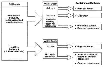
Figure 3-2
Decision tree for containment options for sunken oil. Source: Castle et al., 1995.
Identification of natural depressions and collection points, however, may be very useful for locating sedimented oil and planning for its recovery.
Bottom Booms.
Bottom-mounted boom systems could be used to contain oil on the seabed. The booms could be moored to the seabed and flotation used to maintain the vertical structure of the boom. These systems are only suitable for locations with low currents and little wave activity. No practical applications of these systems have been reported.
Recovery
The recovery of sunken oil has proven to be very difficult and expensive because the oil is usually widely dispersed. Several of the most widely used recovery methods are reviewed below.
Manual Removal
The manual removal of oil, one of the most widely used recovery methods, involves divers or boat-based personnel using dip nets or seines to collect oil, which is temporarily stored in bags or containers. The purpose of manual recovery is to remove the oil and minimize the collection, handling, treatment, storage, and disposal of other material (oiled sediment, sediment, and water). This approach can be useful for widely dispersed oil, and its effectiveness can be assessed by
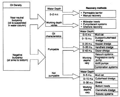
Figure 3-3
Decision tree for recovery options for sunken oil. Source: Castle et al., 1995.
cleanup standards or criteria. The biggest disadvantages of manual removal are the large manpower and logistical requirements, slow rates of recovery, strong dependency on weather conditions, and the potential for the oil to be transported while it is being recovered.
Pump and Vacuum Systems
These systems have historically been most successful for removing large volumes of sunken oil. They typically consist of a submersible pump/vacuum system, an oil-water separator, and a storage container. The systems can be mounted on trucks, on land, or on barges or ships. The suction head of the system is normally directed and controlled by divers and may have an air or water injection system to assist in fluidizing and transporting the slurry. The pumped material is usually a mixture of water, oil, and oiled sediment. Highly viscous or solid oils are usually not pumpable and, hence, are not recoverable with this method.
High-energy pumping systems cannot be used because of their potential for breaking up oil droplets or globules and emulsifying the oil. The pumped mixture is typically routed to an oil-water separator from which the oil and oiled sediment
are removed and stored. The water may be stored for treatment or released into the sea. Oil-water separation may be difficult if the recovered oil is denser than the recovered water. Pumps and vacuum systems are effective if the oil is localized but are not practical for large areas. They also require extensive equipment and the capacity to handle and treat large volumes of water and sediments.
Nets and Trawls
In addition to containing dispersed oil, nets and trawls can also be used as collection devices (Brown and Goodman, 1987; Delvigne, 1987). This approach is most successful when the relative velocity of the water and the oil collected in the net or trawl is low and the viscosity of the oil is high. The effectiveness decreases as the permeability of the net is reduced and flows are diverted around the net (Delvigne, 1987).
Dredging
Dredging is an efficient, well developed method for removing large volumes of sediment (and oil) from the seabed at high recovery rates. Castle et al. (1995) provide a summary of the operating characteristics of a wide variety of dredging systems routinely considered for the removal of sunken oil. Additional information on the feasibility of dredging for the cleanup of sunken oil is given in Bonham (1989). Large volumes of water, oil, and sediment are typically generated in the dredging process and must be handled, stored, and disposed of as the recovery operation proceeds. Accurate vertical control of the dredge depths is critical to minimizing the amount of dredged material and the amount of clean sediment contaminated with oil as the result of the dredging operation. Operational costs and logistics requirements are lower for land-based than for barge-based methods of handling and storing dredged materials. Given the potential for storms that increase freshwater flows and shipping traffic, both of which can resuspend or remobilize sunken oil, the timeliness of dredging is crucial.
Onshore Recovery
In some cases, oil that has been submerged and mixed with sediment enters the surf zone and is eventually moved onshore and deposited on the shoreline. In these cases, conventional shoreline cleanup methods can be used to remove the oil.
Summary
The containment and recovery of oil dispersed in the water column or deposited on the seabed are very difficult. The problem begins with locating the oil and determining its status. The success of current methods varies greatly but is usually
TABLE 3-3 Options for Containing Oil Suspended in the Water Column
|
|
Pneumatic Barriers |
Net Booms |
Slit Curtains |
|
Description |
Piping with holes is placed on the bottom, and compressed air is pumped through it, creating an air bubble barrier. |
Floating booms with weighted skirts (1–2 m long) composed of mesh designed to allow water to pass while containing suspended oil. |
During dredging operations, silt curtains are deployed as a physical barrier to the spread of suspended oil; weighted ballast chains keep the curtain in place. |
|
Availability of Equipment |
Uses readily available equipment, although in unique configuration. |
There are commercially available net booms have been developed and tested for containing spills of Orimulsion; little availability in the United States. |
Not readily available; limited expertise in deployment and maintenance. |
|
Logistical Requirements |
Moderate; requires a system to deploy and maintain bubbler; piping has tendency to clog; high installation costs. |
Moderate; similar to deployment of standard booms, but with added difficulty because of longer skirt; can become heavy and unmanageable. |
Moderate; deployment and maintenance. |
|
Operational Limitations |
Only effective in low currents (<0.2 m/sec), small waves, and shallow water >2 m. |
In field tests, the booms failed in currents <0.75 knots; very limited few conditions. |
Only effective in very low currents (<10 cm/sec); practical limits on curtain depth are 3–6 m, which normally doesn't extend to the bottom. |
|
Optimal Conditions |
To contain oil spilled in dead-end canals and piers; to protect water intakes. |
Will contain oil only in very low-flow areas, such as dead-end canals and piers. |
Still water bodies such as lakes; dead-end canals. |
|
Pros |
Does not interfere with vessel traffic. |
Can be deployed similar to traditional booms. |
Can be deployed throughout the entire water column. |
|
Cons |
Only effective under very limited conditions; takes time to fabricate and deploy, thus only effective where pre-deployed; little data available to assess performance. |
Only contains oil suspended in the upper water column, to the depth of the mesh skirt; unknown whether the mesh will clog and fail at lower currents. |
Effective under very limited conditions, not likely to coincide with location where oil needs containment; oil droplets are larger than silt and could clog curtain. |
TABLE 3-4 Options for Recovering Oil Deposited on the Seabed
|
|
Manual Removal by Divers |
Nets/Trawls |
|
Description |
Divers pick up solid and semi-solid oil by hand or with nets on the bottom, placing it in bags or other containers |
Fish nets and trawls are dragged on the bottom to collect solidified oil |
|
Equipment Availability |
Contaminated-water dive gear may not be locally available |
Nets and vessels readily available in areas with commercial fishing industry |
|
Logistical Needs |
Moderate; diving in contaminated water requires special gear and decon procedures; handling of oily wastes on water can be difficult |
Low; uses standard equipment, though nets will have to be replaced often because of fouling |
|
Operational Limitations |
Water depths up to 60–80 ft for routine dive operations; water visibility of 1–2 ft so divers can see the oil; bad weather can shut down operations |
Water depths normally reached by bottom trawlers; obstructions on the bottom which will hang up nets; rough sea conditions; too shallow for boat operations |
|
Optimal Conditions |
Shallow, protected areas where dive operations can be conducted safely; small amount of oil; scattered oil deposits |
Areas where bottom trawlers normally work; solidified oil |
|
Pros |
Divers can be very selective, removing only oil, minimizing the volume of recovered materials; most effective method for widely scattered oil deposits |
Uses available resources; low tech |
|
Cons |
Large manpower and logistics requirements; problems with contaminated water diving and equipment decon; slow recovery rates; weather dependent operations |
Not effective for liquid or semi-solid oil; nets can quickly become clogged and fail; can become heavy and unmanageable if loaded with oil; could require many nets which are expensive |
limited because the oil, which is mixed with sediments and water, is usually widely dispensed. In general, the success is greatest when the current speeds and wave conditions at the spill site are low, the oil is pumpable, the water depths are relatively shallow, and the sunken oil has concentrated in depressions or collection areas. The selection of containment and recovery methods is highly dependent on the specific location and environmental conditions during the spill, the
|
|
Pump and Vacuum Systems (Diver-directed) |
Dredging |
|
Description |
Divers direct a suction hose connected to a pump and vacuum system, connected to oil-water separator, and solids containers. Viscous oils require special pumps and suction heads. Even in low water visibility, divers can identify oil by feel or get feedback from top-side monitors of changes in oil recovery rates in effluents |
Special purpose dredges, usually small and mobile, with ability for accurate vertical control. Uses land or barge-based systems for storage and separation of the large volumes of oil-water-solids. |
|
Equipment Availability |
Readily available equipment but needs modification to spill conditions, particularly pumping systems, and capacity for handling large volumes of materials during oil-water-solids separation |
Varies; readily available in active port areas; takes days/week to mobilize complete systems |
|
Logistical Needs |
High, especially if recovery operations are not very close to shore. On-water systems will be very complicated and subject to weather, vessel traffic, and other safety issues. |
High, especially if recovery operations are not very close to shore, because of large volumes of materials handled. On-water systems will be very complicated and subject to weather, vessel traffic, and other safety issues. |
|
Operational Limitations |
Water depths up to 60–80 ft for routine dive operations; water visibility of 1–2 ft so divers can see the oil; bad weather can shut down operations; solid oil which is not pumpable |
Min/max water depths are a function of dredge type, usually 2–100 ft; not in rocky substrates; bad weather can shut down operations |
|
Optimal Conditions |
Sites adjacent to shore, requiring minimal on-water systems; liquid or semi-solid oil; thick oil deposits, good visibility; low currents |
Large volume of thick oil on the bottom; need for rapid removal before conditions change and oil is remobilized, buried by clean sediment, or will have larger environmental effects |
|
Pros |
Most experience is with this type of recovery; diver can be selective in recovering only oil and effective with scattered deposits; |
Rapid removal rates; can recover non-pumpable oil |
|
Cons |
Very large manpower and logistics requirements, including large volumes of water-oil-solids handling, separation, storage, and disposal; problems with contaminated water diving and equipment decon; slow recovery rates; weather dependent operations |
Generates large volumes of water/solids for handling, treatment, disposal; large logistics requirements; could resuspend oil/turbidity and affect other resources |
characteristics of the oil and its state of weathering and interaction with sediments, the availability of equipment, and logistical support for the cleanup operation. In addition, the potential environmental impacts of implementing these methods, particularly in sensitive benthic habitats, must be considered. Tables 3-3 and 3-4 summarize the uses and limitations of various containment and recovery methods.


