
2
The Coastal and Marine Geology Program
The Coastal and Marine Geology Program (CMGP) is an extremely important component of the Geologic Division (GD) of the U.S. Geological Survey (USGS). It conducts research and provides data on the critical interface between land and sea and on the continental margins out to the limit of the U.S. Exclusive Economic Zone (EEZ). It is currently the third-largest program (in terms of funding) in the GD (after Mineral Resources and Earthquake Hazards), with a FY99 appropriation of $38,2 million (Figs. 2-1a and 2-1b).
The role of the USGS in conducting studies to understand the coastal and marine areas of the United States was acknowledged in 1994 with the implementation of a five-year National Marine and Coastal Geology Program Plan (USGS, 1994b). This plan was then modified in 1997 to take advantage of new opportunities and issues and to account for changes in budgets and staffing (USGS, 1997).
The stated mission of CMGP is to "provide the nation with objective and credible marine geologic science information based on research, long-term monitoring, and assessments." CMGP is designed to describe marine and coastal geologic systems; to understand the fundamental processes that create, modify and maintain them; and to develop the capability to predict future change through models that integrate the characteristics of natural systems and the effects of human activities.
In the committee's opinion, CMGP conducts unbiased, high-quality scientific research and provides key geologic data and information to address issues along the U.S. coast and within the U.S. EEZ. The broad base of CMGP scientific and technical expertise allows the creation of diverse teams that can (i) conduct integrated, field-based scientific research in all coastal and marine envi-
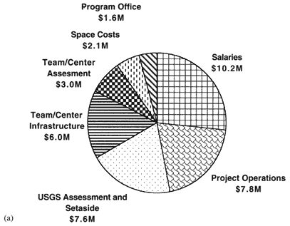
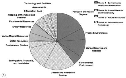
Figure 2-1
(a) Breakdown of the Coastal and Marine Geology Program budget (FY 1999) (Appendix E). (b) Breakdown of funds used to support specific research efforts (including staff salary and operating expenses, FY 1999) by theme (Appendix E).
ronments; (ii) investigate and model interactions among geologic, chemical, and fluid processes; and (iii) complete large, long-term, regional and national, and multidisciplinary studies and assessments of coastal and marine geologic issues. This view of the role of the CMGP was supported by perspectives provided by USGS staff, federal and state agencies, and other users and collaborators (Appendix C).
THEMES OF THE CMGP
Effective guidance for CMGP's future must be predicated on a solid understanding of the nature and abilities of the CMGP today. Consequently, the committee spent considerable time reviewing ongoing projects and present capabilities of the CMGP. These are discussed here to more fully enlighten the reader about CMGP as it exists today and to form a basis for future change.
The 1997 Five-Year Plan identified four themes as the focus of investigations in CMGP: 1) environmental quality and preservation, 2) natural hazards and public safety, 3) natural resources, and 4) information and technology. Studies in each of these scientific themes are broken down into two general types: fundamental and regional. Fundamental studies, which typically account for approximately 5 percent of the annual CMGP budget (Fig. 2-1b), are designed to improve the basic quantitative understanding of the complex geologic processes active in the marine and coastal environments. Results from such studies are relevant to a wide variety of coastal and marine regions, and they also enhance predictive capabilities useful for anticipating future long-and short-term changes. Regional studies typically develop a description of a specific marine and coastal geologic system where problems significant to specific subthemes are identified. A description of the present CMGP focus and activities, organized by the themes and subthemes, is presented below.
Theme 1: Environmental Quality and Preservation
With the growing pressures from human activities along the U.S. seaboard, the quality and preservation of the coastal and marine environment have become urgent issues. Science-based management of these areas requires the development of a basic understanding of the natural and anthropogenic factors that influence the quality of the environment. The CMGP has a role in investigating the dynamics of geologic processes affecting our coastal and marine environments today through sampling, data collection, and modeling (e.g., the Large-Scale Coastal Modeling Project and the Inner Shelf Dynamics Project). In addition, by participating in such multiagency, multiinstitutional projects as STRATAFORM (the Origin of Marine Stratification), the CMGP also examines long-term geologic changes through studies of the sedimentary records preserved in seafloor environments. Such studies provide the geologic framework of the coastal areas
and continental margins and define the geologic processes that underpin many factors impacting the quality of the marine environment.
The other major area of concern is sea-level change. There is a pressing need to develop models to predict the future of sea-level change and its impact on the United States. Areas particularly sensitive to sea-level changes are the coastlines, coastal wetlands, and coral reefs. The CMGP is conducting regional studies to account for both global sea-level changes and local land subsidence and uplift along the coastline. An excellent example of such a study is the investigation of the effects of sea-level rise and subsidence on the Louisiana coast.
Subtheme 1: Pollution and Waste Disposal
The legacy of the use of the ocean for waste disposal and the present and future management of such activities are issues of considerable concern. The range of waste materials and pollutants (e.g., heavy metals, garbage, radioactive waste, nutrients, organic chemicals, and microbes), and their variety of behaviors in the coastal and marine environment, require that a combination of basic scientific and applied regional studies be undertaken (see Box 2-1).
The CMGP is studying sediment transport processes and the long-term fate of pollutants (e.g., in Massachusetts Bay, Long Island Sound, Florida's Santa Monica Bay, Hawaii, Monterey Bay, Lake Pontchartrain); the physics, chemistry and biology of sediment-pollutant interactions (Boston Harbor); and sediment mixing and sorting processes (e.g., mechanisms of sorting in sand and shell hash beds on the west Florida shelf) to better understand the controls on the distribution and ultimate fate of waste materials and pollutants in the ocean. Regional studies are also under way to map the distribution of contaminants (e.g., barrels of radioactive waste in the Gulf of the Farallones; hydrocarbons in Prince William Sound); to model local circulation patterns and the associated sediment transport (e.g., on the Los Angeles shelf and on the continental slope off San Francisco); and to investigate the local processes that could result in remobilization of contaminants from the seafloor (e.g., metal concentrations in Boston Harbor sediments).
Subtheme 2: Fragile Environments
Coastal and marine environments are host to a variety of fragile environments that exist in areas of transition where a delicate balance between two types of environments must be maintained. For example, the coastal wetlands that act as the nursery grounds for species comprising about 80 percent of U.S. commercial and recreational fisheries occur at the interface of salt-and freshwater and require a delicate balance among physical and chemical oceanographic processes to maintain their health. Along the continental slopes and on the mid-ocean
|
BOX 2-1 BOSTON HARBOR The results of the USGS study of Boston Harbor and Massachusetts Bay have been used to help make management decisions throughout the Boston Harbor Cleanup Program. The focus of USGS activities is to provide an understanding of the fate and transport of contaminated sediments (USGS, 1998b, 1998c, 1998d, 1998h, 1999). The USGS side scan sonar maps of the seafloor in western Massachusetts Bay (Plate 2) were used by the Massachusetts Water Resources Authority (MWRA) to help decide between two alternative sites for Boston's new sewage outfall (MWRA, 1996). According to Paul F. Levy, former executive director of MWRA, the timely production of this map saved MWRA the significant expense of geotechnical studies of the rejected site. USGS maps of the bottom characteristics in Boston Harbor, Massachusetts Bay, and Cape Cod Bay were used in the design of the federally required MWRA monitoring program. The maps contributed to a more efficient and cost-effective monitoring program by identifying areas of similar sediment types (that could then be characterized by fewer measurements), as well as areas where changes over time could be most clearly documented. The maps of bottom types also have been useful to fishermen. USGS computer models of circulation (Fig. 2-2) illustrate the comparative impact of sewage from Boston's existing and future outfall (Plate 3). The models suggest that, when the outfall is moved to the offshore location, water quality will improve dramatically in Boston Harbor and neither the beaches of Cape Cod nor the area around Stellwagen Bank will be exposed to increased sewage. The model was used by the U.S. Attorney's Office (Department of Justice) in defending the government in the endangered species case concerning right whales in the Stellwagen Bank National Marine Sanctuary. The results also were useful in public and congressional hearings by providing an unbiased assessment of the consequences of management actions. The model results also helped MWRA evaluate and gain approval for downsizing the planned secondary sewage treatment plant, which saved Boston area rate payers $160 million. USGS studies in Boston Harbor have documented that the concentrations of most toxic heavy metals in surface sediments have decreased to about 50 percent of the levels measured in the late 1970s. The continuing long-term observations provide regulatory agencies and the public with clear evidence that the cleanup program, specifically those efforts to reduce contaminants entering the harbor, is resulting in measurable improvement (Long et al., 1995; USGS, 1998b, 1998c, 1998d, 1998h, 1999). The USGS-MWRA Massachusetts Bay Project and joint funding agreement is a model for state and federal cooperatives. The USGS studies provided scientific information that contributed directly to the success of a major public works project to improve the environment in Boston Harbor and Massachusetts Bay. The Massachusetts Bay project also provided the USGS opportunities to develop mapping, monitoring, and modeling capabilities for sediment contaminant studies in other U.S. coastal areas. |
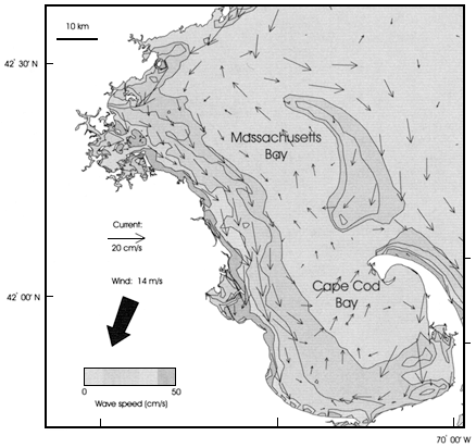
Figure 2-2
Modeled wind-induced currents (arrows) and contours of near-bottom wave current speed driven by a northeasterly wind of 14 m/s (28 knots). Nearbottom wave speeds in excess of about 10 cm/s are sufficient to resuspend finegrained sediments. During major northeasters, fine sediments along the western shore of Massachusetts Bay are resuspended by the wave currents and transported by the wind-driven flow to the southeast toward Cape Cod Bay, where they settle. They are protected from the influence of subsequent storms by water depth and basin geometry. The numerical circulation models provide predictions of the basinwide storm response, which would be very difficult to observe directly (USGS, 1998b).
ridges, chemosynthesis-based exotic biological communities survive at the interface between seawater, groundwater, and hydrothermal vent fluids, respectively. Other environments (e.g., coral reefs) are fragile because they have been impacted in historical times by natural processes and anthropogenic activities. Fundamental studies of the dynamics of estuarine and coastal systems (e.g., Chesapeake Bay), wetlands (e.g., Gulf of Mexico southeast tidal wetlands, San
Francisco Bay, Florida) and regional studies of specific systems that are currently being stressed (e.g., Hawaiian coral reefs) are under way in the CGMP.
Subtheme 3: Marine Reserves and Habitats
In recent years, a number of marine and coastal areas have been designated for conservation and sustainable use. These include national marine sanctuaries, national seashores, national marine parks, areas in the U.S. Environmental Protection Agency (EPA) Bays Program, and other federal coastal and estuarine reserves. Comprehensive geologic scientific information is required to understand the dynamics of these environments and make sound management decisions. In several instances, the management agencies have requested that the USGS provide seafloor bathymetry and sediment distribution maps (e.g., for Stellwagen Bank, Florida Keys, Monterey Bay), which are critical to managing marine reserves. In addition, many biological habitats in the nearshore and offshore regions are being affected by such human activity as waste disposal, seabed disturbance from fishing gear, and overfishing. Understanding the impact of these activities on the seafloor substrate and habitat is critical to managing these economically important areas (Box 2-2), and again the CMGP was asked to apply unique expertise and mapping capabilities.
CMGP research focuses on documenting the changes in biological habitats caused by natural processes and anthropogenic activity (e.g., overfishing on Georges Bank, trawling disturbances on the California coast, snapper habitats off Hawaii).
|
BOX 2-2 FISHERIES HABITAT MAPPING IN NEW ENGLAND During the last five years, CMGP seafloor mapping projects in New England's Gulf of Maine have addressed the need to describe biological habitats in terms of their geologic attributes and processes and their importance to fishery species (Butman and Schwab, 1997). Studies have been conducted on Georges Bank and in the Stellwagen Bank off Boston, Massachusetts (Fig. 2-3). The depressed state of the New England fishery required policymakers and managers to develop regulations to conserve and rebuild the fishery by limiting catches and by placing large areas of the seabed off limits to fishing. The 1996 Magnuson-Stevens Fishery Conservation and Management Act requires that the National Marine Fisheries Service and the regional Fishery Management Councils identify and protect essential fish habitats for the most important fishery species. This requirement increased the need for the study of seafloor habitats to conserve fish stocks and to assess and prevent destruction of essential fish habitats by fishing gear (USGS, 1998e). This issue is addressed through the collaboration of the CMGP, four National Oceanic and Atmospheric Administration offices (National Marine Fisheries Ser- |
|
vice, National Ocean Service's Coast Survey, National Marine Sanctuaries Division, and National Undersea Research Program), the EPA, the New England Fishery Management Council, and scientists from the University of Rhode Island and the University of Connecticut. The CMGP conducts the mapping and geological investigations and works with biologists in regions where collaborating agencies have identified important environmental and fishery habitat issues. The National Marine Fisheries Service has a major role in information gathering activities and in the management of the fishery, and it provides financial support for academic biologists and contributes ship time. The National Ocean Service's (NOS) Coast Survey carries out hydrographic mapping and was interested in the utility of multibeam mapping systems for its bathymetric surveys. NOS funded half of the Stellwagen Bank multibeam survey, and National Oceanic and Atmospheric Administration (NOAA) officers participated at sea to train for the new technology, which now has been adopted for its own surveys. The Sanctuaries Division of NOS manages the sanctuary and provides support in the form of ship time for geological and biological sampling in the Stellwagen Bank region. It disseminates results to the public and schools through its outreach program. NOAA's National Undersea Research Program supports research on marine environments and habitats through the use of submersibles and remotely operated vehicles and has supported biological investigations by academic biologists in the mapped regions. The EPA is a joint manager (with the U.S. Army Corps of Engineers) of the Massachusetts Bay disposal site off Boston, Massachusetts, and also is concerned with the past disposal of toxic and radioactive materials in the region. It provided ship time for sampling to aid in interpretation of the multibeam imagery of the disposal site. The USGS role has been to map and characterize the seafloor environments and processes at scales meaningful to biologists and managers. The New England Fishery Management Council makes fishery management decisions and essential fish habitats and identifies important issues that need to be addressed through seafloor mapping and habitat research. These collaborative studies have identified seafloor processes, species-habitat relationships, and effects of fishing gear on seabed communities that are a basis for regulatory decisions by the New England Fishery Management Council. The council raised the protection level of an important habitat in a presently closed area of Georges Bank by designating it a habitat area of particular concern. The council considered designating a like habitat in another region, but decided that available historic information was inadequate. It is relying on results of a recently initiated CMGP mapping project in Great South Channel to help make a decision. The council now is deliberating how best to reopen a scallop fishery in an area closed to all fishing on Georges Bank. In the face of political pressure to open the scallop fishery, the council has research results to help develop a management plan that will protect the most important groundfish habitats in the area. The council's recent mandate to manage and protect essential fish habitats greatly increases the need for habitat mapping and research. Environmentalists have become concerned about the effect of human impact, in various forms, on biological habitats. The Gulf of Maine has become the focus of initiatives to establish marine protected areas to conserve biodiversity and rare assemblages. The research efforts described above by USGS and its partners are a major influence on the debate about how to manage marine environments. Finally, the EPA used the results of mapping the Massachusetts Bay disposal site in revising regulations for its management. |
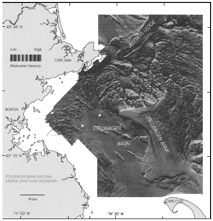
Figure 2-3
Sun-illuminated map of Stellwagen Bank National Marine Sanctuary and Massachusetts Bay with backscatter intensity draped over the topography (USGS, 1998e).
Theme 2: Natural Hazards and Public Safety
The overall goal of the natural hazards and public safety theme is to better understand the processes that produce hazards in the coastal and marine environment and their impact on the human population and the natural environment. There is a critical need to better predict the frequency and distribution of catastrophic events that elicit federal response (storms, earthquakes, and landslides); the geologic, human, and environmental consequences of such events; and the local and regional susceptibility to change, such as coastal erosion. Since the
types of catastrophic events along different parts of the coastline vary, the studies are necessarily regional in nature.
Subtheme 1: Coastal and Nearshore Erosion
Coastal erosion is a national problem, with enormous economic and social consequences that affect all 30 states bordering the ocean or the Great Lakes. Sediment generation, transport, and redistribution along our coastlines and across the continental shelf are the natural processes by which coastline and nearshore environments evolve. However, the development of large tracts of the coastline as urban and suburban areas, as well as human activities to reshape the coastlines and intercede in the natural riverine, estuarine, and coastal sediment transport processes, have exacerbated the problem of coastal erosion in many areas. The geologic framework of the coastal region and the sediment transport system must be determined in order to understand the problems that must be addressed to maintain U.S. coastlines and to predict the regional effects of any mitigation or management plans. The CMGP is uniquely placed to undertake studies of large-scale geologic processes that shape the coastlines and influence the distribution of sediments along the coast and across the continental shelf (e.g., predictive modeling of bedload transport and cross-shelf sediment transport). In addition, CMGP also addresses local erosion problems and sediment budgets (see Box 2-3), as well as the impact of catastrophic storms and hurricanes (e.g., South Carolina, west central Florida, Louisiana, Hawaii). CMGP has also used new techniques for measuring shoreline position that can provide broad coverage of coastal topography and nearshore bathymetry and can be deployed to key areas before and after major storms (e.g., a global positioning system-based, vehicle-mounted system called SWASH, short for ''surveying wide area shorelines,'' and a coastal and nearshore mapping device that uses a scanning airborne laser, called LIDAR).
Subtheme 2: Earthquakes, Tsunamis, and Landslides
Much of the coastal region of the United States lies in close proximity to the boundaries of major tectonic plates (e.g., the west coast of North America, Puerto Rico and the Virgin Islands, and U.S. territories in the Western Pacific) or is on active volcanic islands associated with hot spots (e.g., Hawaii). These areas are therefore at risk from large earthquakes (both onshore and offshore) and undersea and coastal landslides. These, together with tsunamis that can be generated by earthquake, volcano, or landslide events, pose a serious threat to the growing coastal population centers, and such events continue to cause loss of life and property, as well as disruption to the societal infrastructure. In conjunction with the on-land studies of the USGS Earthquake Hazards Program, the CMGP has a responsibility to advance scientific knowledge of the geologic processes that result in earthquakes and landslides and to provide the scientific basis for deci-
|
BOX 2-3 EROSION IN SOUTHWEST WASHINGTON After long periods of shoreline accretion and subsequent private and public development near the coast in southwest Washington state, recent shoreline retreat is putting at risk private property, a public highway, commercial cranberry bogs, community water supplies, wastewater treatment plants, and two state parks (Gelfenbaum et al., 1997; Gelfenbaum, 1998; SWCER, 1997) (Figs. 2-4a and 2-4b). CMGP is working cooperatively with the State of Washington's Department of Ecology (WDE), with input from local communities on a coastal erosion study funded by the USGS and the state. The USGS co-directs the study, assuring objective and uniform techniques across state boundaries, and conducts some of the research, primarily sediment budget, offshore and geologic framework-related tasks. WDE co-directs the study, interfacing with local communities and other users (state agencies, etc.), performs data management, and maintains the study Geographic Information System (GIS), and conducts some of the research, primarily that related to the beach and shoreline. Research tasks were assigned to the two agencies based on available technical skills and which tasks would need to continue after the study ended. WDE is being asked to make predictions of future shoreline positions for Washington state parks for two areas using data obtained from the study. The state parks department is using the predictions to plan for the relocation of a campground and to scale back road repairs in a chronic erosion area (Gelfenbaum et al., 1999). WDE is also asked to comment on technical reports dealing with a U.S. Army Corps of Engineers proposed coastal construction plan, an environmental impact statement for a local city's plan to deal with erosion, and a Corps environmental impact statement for proposed dredge disposal. The USGS sat on the governor's Task Force for Coastal Erosion as a representative of the coastal erosion study. The task force recently completed its report, which recommended long-term planning for all coastal communities, conducting an inventory of at-risk infrastructure, and planning for coastal erosion hazards. The USGS and WDE co-produced an educational video on the coastal erosion problem in southwest Washington and on the scientific study that is under way to study the problem. Some 150 copies of the video have been distributed, and a dozen cable TV networks are preparing for showings. |
sions on seismic risk, building codes, public disaster plans, and land use and development. To evaluate the potential for large events and to model the likely impacts, CMGP is conducting geological and geophysical work in the Pacific Northwest, the California borderlands, and the northeast Caribbean. It is also analyzing the large volume of data collected from earthquakes to model their hazards. Coastal cliffs are being studied south of San Francisco to determine factors controlling slope instabilities. To assess the risks of disaster and to aid in mitigation planning, regional studies are focused on areas at high risk, providing a geologic framework in the context of historical events and their associated damage.
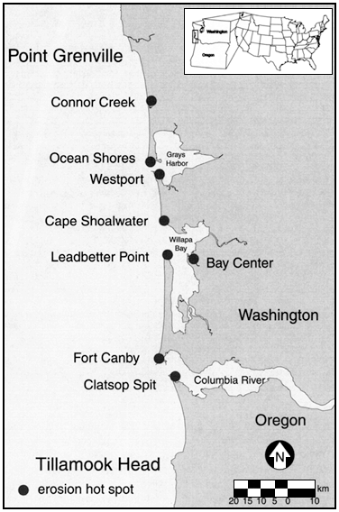
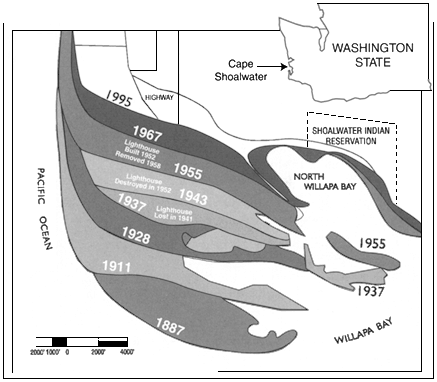
Figure 2-4b
History of shorline retreat at Willapa Bay, Washington (SWCER, 1997).
Theme 3: Natural Resources
The increase in population in the United States will put increasing strains on the nation's natural resources. The identification of new mineral and energy resources in the marine environment and a better understanding of the geologic controls on subsurface flow of groundwaters in the coastal zone are critical to the management of the supply of resources. CMGP studies of natural resources are broken down into three subthemes (with the objective of understanding the formation, location, and geologic setting of coastal and marine natural resources; the geologic effects of resource extraction and its impact on coastal and marine ecosystems; and how onshore exploration for economic mineral deposits can be refined and broadened, based on information gained from offshore resource occurrences.
Subtheme 1: Water Resources (Coastal Aquifers)
In many coastal communities, declining groundwater levels and increasing demand for freshwater by the burgeoning population have led to intrusion of saltwater into coastal aquifers. It is critical to understand and model the subsurface fluid flow between onshore and offshore aquifers if coastal aquifers are to be managed effectively. Subsurface fluid flow is governed to a large extent by the characteristics of the subsurface geology; hence the geologic framework is required as a basis for determining fluid flow patterns and the chemical reactions between the fluids and the host rocks. CMGP is conducting geologic framework studies of saline encroachment and nutrient transport in coastal aquifers in San Pedro in southern California, the Delmarva penninsula, and in south Florida (Box 2-4).
Subtheme 2: Marine Mineral Resources
This subtheme encompasses a variety of materials that are found in the coastal and marine environment, ranging from sand and gravel needed for aggregate supply and beach replenishment to such metals as manganese, copper, nickel, platinum, cobalt, and zinc, which are critical for industrial and strategic uses. They are the products of dynamic physical, chemical, and biological processes that result in the minerals being concentrated in specific areas. Understanding those processes and their role, the overall geologic system of the coastal ocean, and the EEZ is an appropriate role for CMGP. In conjunction with the land-based Mineral Resources Program, the CMGP also has a regional responsibility to determine the nature and extent of offshore mineral deposits and assess their viability as an economic resource. CMGP focuses on three types of deposits: 1) sand, gravel, and heavy mineral concentrates formed in coastal and shelf areas by sedimentary processes (e.g., Hawaii, Long Island); 2) phosphorites and iron-manganese crusts formed in shelf and deep-sea areas by low-temperature hydrogenic processes (e.g., eastern Pacific, Blake Plateau); and 3) polymetallic sulfides formed in oceanic rift zones, island arcs, and on mid-plate volcanoes (e.g., northeast Pacific ridges, west Pacific island arcs).
Subtheme 3: Energy Resources
Offshore oil and natural gas deposits represent a significant component of the potential energy resources of the United States, so it is appropriate for the CMGP to maintain strong research programs that advance our knowledge of the formation, migration, accumulation, and distribution of oil and gas, particularly as related to the geologic processes that have formed the continental margins (e.g., Gulf of Mexico). In addition, studies in recent years have documented that gas hydrates may be abundant in the sediments on the deep continental margins and may represent an important global reservoir of carbon. The CMGP has a
|
BOX 2-4 GROUNDWATER IN THE FLORIDA KEYS Groundwater quality in the Florida Keys is often degraded by processes related to aquifers that introduce freshwater into marine settings or saltwater into freshwater settings or that store freshwater in marine sedimentary reservoirs. In addition, treated sewage is injected into the limestone under the Florida Keys by onsite disposal systems. There are approximately 25,000 septic tank systems, 5,000 cesspools, and 1,000 Class 5 injection wells. Depth of injection wells ranges from 10 to 30 m. Excessive algal growth, coral disease (Plate 4), and marine grass and sponge mortality are perceived by the local population, NOAA, and EPA to be caused by sewage nutrients leaking from the groundwater on both sides of the Florida Keys. Determining the rate and direction of saline groundwater movement beneath the Keys and Florida Bay is critical to understanding the fate and effects of subsurface waste disposal in the Florida Keys (Shinn et al., in press). CMGP studies conducted there involve the synthesis of regional geologic data; development of models of fluid flow, mixing processes, discharge, and mass and fluid flux; analysis of water chemistry where possible; and development of strategies and technologies for identification of additional offshore aquifers (Shinn et al., in press; Lidz, 1997). As a direct result of CMGP groundwater research, EPA issued a letter to the State of Florida stating that the geology of the Florida Keys is unsuitable for the use of shallow wastewater (Class 5) disposal wells. Two major actions have resulted from this notice:
Other significant findings resulting from the CMGP study include recognition that there is a rapid exchange of groundwater and surface waters in the Keys that is driven by tidal pumping. In areas where groundwater is saline, injected wastewater is buoyant and rapidly rises to the surface. Furthermore, recent tracer studies have demonstrated rapid migration of Class 5 effluent (sewage) to surface waters (hours to days). These studies demonstrated that tracers were greatly diluted before reaching surface waters and that some phosphorus was stripped from groundwater by the substrate. The long-term ability of phosphorus stripping by the substrate is currently under investigation. Disposal of wastewater from package treatment plants or on-site disposal systems into Class 5 injection wells results in nutrient enrichment of the groundwater that in turn contributes to eutrophication of the surface and marine waters. |
significant role in studying gas hydrates through a four-phase research program that includes geophysical surveys to map the distribution of gas hydrates in sediments, laboratory experimentation to define the physical characteristics of gas hydrates, geochemical studies to determine the processes of formation, the composition and stability of gas hydrates, and quantitative well-log evaluation to identify likely gas hydrate horizons.
Theme 4: Information and Technology
A critical function of CMGP is to collect, and make readily available, basic geologic data that can be accessed easily by scientists, policymakers, and the general public. This involves not only using the best-available scientific instrumentation to collect scientific data and maintaining access to ocean platforms on which to work but also synthesizing, managing, and disseminating the information. CMGP is responsible for high-resolution mapping of the EEZ (Box 2-5) and synthesis of the state of knowledge about coastal and marine geologic systems, and it should be the national source of information about the geology and geologic processes of the coastal and marine environment.
Subtheme 1: Systematic Mapping of the Coast and Seafloor
Systematic mapping of the coast and seafloor in the EEZ is an important component of CMGP. These activities provide the base maps for many of the studies conducted under the other CMGP themes, as well as for federal, state, and local agencies in their use and management of the coastal and offshore waters. Maps are produced at a range of scales and include morphology, bathymetry, seafloor lithology, and debris due to human activity. Recent advances in processing and imaging of these data and the ability to overlay data sets have resulted in the production of spectacular three-dimensional visualizations of critical regions of the seafloor (e.g., Stellwagen Bank, Lake Tahoe, Hawaii) that have significantly enhanced the geologic interpretation of the seafloor features. Because the coastal and shallow portions of the continental margin areas are most affected by human activities, they will be the major focus of the CMGP in the next decade. This effort has already begun and is focusing on the shelf areas off major urban areas (e.g., New York-New Jersey, Los Angeles). A particular challenge for CMGP is mapping the very shallow (less than 5 m) coastal and estuarine areas that comprise the critical interface between land and sea.
Subtheme 2: Coastal and Marine Information Bank
A priority for CMGP is the maintenance of a comprehensive information bank containing data in forms that are easily accessible and can be used to facilitate management decisions. This requires a plan to deal with a variety of
|
BOX 2-5 GLORIA—MAPPING THE U.S. EEZ On March 10, 1983, President Reagan declared an expansion of the sovereign rights of the United States to all natural resources in a zone extending to 200 nautical miles beyond the shoreline. This newly proclaimed Exclusive Economic Zone (EEZ) provided a mandate for further exploration. The general bathymetry was known, but the detailed physiography was not well known. Only with such detailed knowledge of the seafloor could the resource potential and the consequences of exploitation or other activities on the physical, biological, or chemical systems of the seafloor (USGS, 1998f). In 1984 the USGS launched a program using a long-range sidescan sonar system (Geologic Long-Range Inclined Asdic [GLORIA] to study the entire EEZ. During the summer of 1984, scientists from the USGS and the Institute of Oceanographic Sciences (IOS) of the United Kingdom surveyed the EEZ off California, Oregon, and Washington, an area of about 850,000 square kilometers. The results of this survey are 36 two-degree sheets, at a scale of 1:500,000. The survey cost approximately one penny per acre. The acoustic images produced by the program are no less remarkable than the first photographs from the far side of the Moon (Chavez, 1986). A cursory glance at the GLORIA imagery reveals a multitude of geologic features: volcanic edifices, fault scarps, channels, levees, slump scars, large sediment bedforms, crustal lineaments, and textural or tonal differences that reflect varying sediment types. These images provide the framework for a "road map" to direct more detailed investigations. As land surveys commonly rely on various types of remotely sensed data, so the clearer perception of submarine features provided by GLORIA enables marine geologists to focus on specific features of interest (EEZ-SCAN, 1986). In the late summer and fall of 1985, the USGS conducted surveys of the EEZ in the Gulf of Mexico and around Puerto Rico and the U.S. Virgin Islands. These 1985 surveys abutted an area surveyed in 1982 as part of the outer continental shelf geohazards work that focused on the Texas-Louisiana continental slope and as part of the preliminary work on the Deep Sea Drilling Project in the Mississippi Fan. The collected GLORIA data were processed and digitally combined to produce continuous imagery of the seafloor. The 1982 and 1985 data sets were combined to produce sidescan coverage of the EEZ in the Gulf of Mexico. Sixteen digital mosaics of a two-degree (or smaller) area with a 50-meter pixel resolution were completed for the Gulf of Mexico. The mosaics were later combined to produce an overview of the Gulf of Mexico (Paskevich, 1996). From February to May 1987, five cruises were conducted to cover the Atlantic Continental Margin EEZ seaward of the continental shelf edge, from the Canadian border southward to the northern Blake Plateau off Florida. The innermost Blake Plateau north of latitude 30°N and most of the plateau south of that latitude were not imaged during 1987 because of lack of time. As in earlier EEZ reconnaissance surveys, the USGS used the GLORIA sidescan sonar system to complete the geologic mapping. Twenty-three digital mosaics of a two-degree by two-degree (smaller) area with a 50-meter pixel resolution were completed for the Atlantic Continental Margin. Twenty-one of the mosaics was later combined to produce an overview of the Atlantic Continental Margin. |
material types, including digital data, paper records, reconnaissance images and bottom photographs of the seafloor, and samples. In addition, technical developments are required for digital data rescue and for continually upgrading the archived material to new formats. The goal is to provide the best-possible comprehensive geologic information about the seafloor within the EEZ (Box 2-6). The CMGP in collaboration with other agencies has already developed local databases for specific components (e.g., the database of contaminated sediments for the Gulf of Maine).
|
BOX 2-6 DINKUM SANDS—APPLICATION OF USGS COASTAL GEOLOGIC KNOWLEDGE TO U.S. SUPREME COURT CASE From the early 1970s to mid-1980s the CMGP conducted research to characterize the continental margin off Alaska's oil-rich north slope. As part of the these pioneering geologic framework and environmental studies, the USGS conducted research to understand the unique ice-related sedimentary and erosion processes that control and modify the coast, barrier islands, and seafloor morphology in the region, thereby promoting an understanding of environmental factors relating to energy resource exploration and production in the Beaufort Sea. A by-product of this research was the impetus it provided to the USGS to adjudicate a dispute between the federal government and the State of Alaska over Dinkum Sands, a shoal in the Beaufort Sea about 21.5 kilometers northeast of Prudhoe Bay. The dispute hinged on whether Dinkum Sands was an island, in which case it and 27 oil lease tracts would belong to the State of Alaska, or whether it was an underwater shoal, in which case the area would belong to the federal government. The case was heard by the U.S. Supreme Court, which in 1996 ruled in favor of the United States. CMGP staff input was based on long-term first-hand local and regional knowledge along with credible research studies on ice-related arctic coastal processes that convincingly demonstrated that the feature was indeed an underwater shoal. As a result, more than $1 billion in oil revenue that had been held in escrow and a half million acres of seafloor were awarded to the federal government. The Justice Department singled out the USGS and the lead scientist for recognition and appreciation. At the present time the interest from the Dinkum Sands escrow account is providing over $6 million per year to the University of Alaska's coastal and marine research community. The USGS Biological Research Division in Alaska has responsibility for administering these funds (Grantz et al., 1980). |
Subtheme 3: Assessments and Evaluation of the Information Bank
The information bank allows for periodic assessments of the adequacy of knowledge about the coastal and marine geologic environment. Other types of assessments requiring regional syntheses of many data sets to address a specific problem (e.g., contaminated sediments, available resources) are also carried out under this subtheme.
Subtheme 4: Technology and Facilities
Marine and coastal studies require a wide range of scientific instrumentation and access to a variety of platforms capable of operating in both shallow and deep water. Individual investigators in the CMGP develop equipment for specific types of measurements (e.g., sediment transport measurements and current direction and speed), real-time data retrieval, and collection of samples (e.g., the Seabed Observation Sampling System, or SEABOSS). Other equipment, such as seafloor swath mapping systems, is often leased to ensure that the most advanced systems are used to obtain the highest-quality data. The CMGP maintains the capability to process seafloor observations and data and to produce data products rapidly and efficiently. In addition, the CMGP maintains specialized analytical and experimental laboratories (e.g., organic geochemistry lab and the Gas Hydrate and Sediment Test Laboratory Instrument, or GHASTLI) for various types of measurements that are critical to its mission.
THE COMMITTEE'S FINDINGS
The committee believes that the CMGP represents an extremely important component of the USGS Geologic Division. It conducts scientific research and assessments on the dynamic and complex geologic systems that underpin the coastal and marine environments, and it is the nation's primary resource for geologic information critical to the management of our coastal and marine environments. CMGP is a program that focuses on a region with myriad geologic processes, as opposed to other USGS programs that focus on a single earth process. This regional focus is needed and is not to be found elsewhere. As such, CMGP fills a critical niche in the USGS by providing the fundamental geologic studies necessary to describe and manage coastal and marine resources.
The committee reviewed the recently published document entitled "Geology for a Changing World" (USGS, 1998h), which presents a science strategy for the Geologic Division for the years 2000–2010. The role of coastal and marine geologic studies in the USGS and the inclusion of the coastal areas and EEZ as part of the responsibility of the USGS are not clearly articulated in this document. Unlike other Geologic Division programs that are each explicitly tied to at least one of the division's seven Strategic Science Goals, the CMGP, because of its geographic focus, addresses aspects of all the goals. As a consequence, CMGP does not appear to be an explicit priority for the Geologic Division, as reflected both in the division's Strategic Science Goals and in the entire planning document. Given the multidisciplinary nature of many of the problems facing policymakers responsible for coastal and marine resources and the unique technical and logistical challenges of working in this area, the committee strongly believes there is a need for a discrete and well-focused program in the
Geologic Division that is dedicated to dealing with coastal and marine geology. This will provide a venue for interdisciplinary studies of the complex marine and coastal systems that would be difficult to undertake in the division's other topical programs. Such studies require different tools and strategic approaches than those used in land-based studies, and CMGP is scientifically and technically best equipped to conduct them. The committee recommends that the role of the CMGP and its unique niche in the USGS be made more visible in USGS planning publications. The USGS, at the highest levels, needs to emphasize the economic and societal importance of understanding both the fundamental nature of the geologic framework of the nation's coastal and marine areas and the role of geologic processes in controlling the quantity, transport, and distribution of living and nonliving resources.
The committee also reviewed the planning documents and current projects of CMGP to determine how clearly the CMGP, its goals, and responsibilities are presented in its publications and in its activities. As presently configured, the CMGP is fragmented into unrelated projects. Although these projects fit into the Geologic Division's Strategic Science Goals on an individual basis, as a group, they do not convey the sense of a coherent scientific effort focused primarily on the geologic framework of coastal and marine areas. The committee determined that there is a need for a CMGP strategic planning process aimed at more strongly identifying the CMGP as playing a leadership role in developing an understanding of coastal and marine geologic processes and providing the geologic framework for science-based management of nearshore and offshore environments. The committee, therefore, recommends that, as part of the strategic planning process, the CMGP develop a new mission statement that identifies the role of the CMGP in the USGS and clearly articulates its responsibilities.
The committee also conducted a review of the themes of CMGP to evaluate how well they map to the Geologic Division's seven Strategic Science Goals; the results are presented in Appendix D. Studies within each of the themes are broken down into fundamental studies that are designed to improve understanding of the complex geologic processes in the marine and coastal environments and more regional studies that fall within well-defined subthemes. The overall conclusion of the committee was that individual projects currently being conducted by CMGP map well into the Geologic Division's science goals, but they do not group into coherent scientific efforts in the themes and subthemes. For example, topics in CMGP Theme 1 (Environmental Quality and Preservation) are the sedimentary record of long-term geologic change, the dynamics of natural sediment transport processes, the transport of pollutants, and marine reserves.
The Geologic Division approaches geological studies of the environment from the ''hazard, impact, or change'' (whether natural or anthropogenic) perspective, which fits well with CMGP Theme 2 (Natural Hazards and Public Safety) and its subthemes. However, in the Geologic Division there are four other programs that address hazards of various types (e.g., the earthquake, volcano, landslides, and
global seismic network programs) and how the CMGP efforts dovetail into the larger efforts of these other programs is a concern. Similarly, Theme 3 (Natural Resources) directly addresses the Geologic Division's Goal 3, plus it also incorporates a subtheme of water resources that is not reflected in the general description of Theme 3. This raises the issue of how CMGP studies integrate with the Water Resources Division of the USGS and the Minerals Resources and Energy Resources programs in the Geologic Division. Finally, Theme 4 (Information and Technology) focuses on infrastructure issues that directly address the Geologic Division's operational, rather than scientific, objectives.
Clearly, information management, maintenance of scientific instrumentation, and access to platforms are central to the accomplishment of coastal and marine research and therefore to the successful dissemination of information to the public and to policymakers. These functions are extremely important to the success of CMGP and must be maintained as a critical operational component of the CMGP. However, the committee felt that the definition of these functions as one of the major scientific themes does not fit well with the Geologic Division's Strategic Science Goals. The committee therefore recommends that the themes and subthemes of the CMGP address the geologic framework component of scientific issues in coastal and marine regions. While maintaining a close link to the Geologic Division's Strategic Science Goals, CMGP should redefine the themes to address fundamental scientific issues or what the committee concluded are grand challenges related to the coastal and marine realm through coherent project groupings. The responsibility for information management, dissemination, and maintenance of scientific instrumentation and platforms does not represent a theme but should be emphasized as a separate but critical function of CMGP. Greater discussion of the possible nature of these grand challenges is the subject of Chapter 3.


