
4
The Federal Role
Through the efforts carried out at each of the regional centers CMGP has developed a rich history of conducting high-quality scientific research on the dynamic and complex geologic systems that comprise the near-and offshore marine environments. Examination of the recent CMGP history suggests that some capabilities have been diminished in recent years by attrition and administrative actions. The committee also found, based on a review of planning documents from the USGS Geologic Division and the CMGP and input from the staff, that no clear and focused identity exists for the program nor does it seem to have a clear mission definition. The committee believes that CMGP, by organizing activities at all three regional centers based on an integrated plan that addresses the grand challenges discussed in Chapter 3, would be well positioned to focus on national, regional, and site-specific coastal and marine issues and problems.
The multidecade time horizon necessary to address the grand challenges means that shorter-term milestones and priorities will need to be established for CMGP. The following sections outline a suggested basis for redefining the CMGP's role and mission in the USGS while addressing the grand challenges.
DEVELOPING NEAR-TERM FOCUS
The recommendations for a long-term CMGP vision in Chapter 3, and the implementation of this vision through development of a strategic plan, will require substantial program refocusing through major changes in proposal development, allocation of finances, nature of personnel, interactions between the centers and headquarters, and many other operational procedures. Such changes will require considerable time to reach the goal of becoming the preeminent federal
agency for fundamental geologic information about U.S. continental margins. The committee feels that progress toward these goals can be made in the shorter term by refocusing the scientific efforts at all three CMGP centers to address a few pressing issues that could serve as the initial steps needed for the grand challenges. Such a refocusing should foster closer interaction of scientific personnel, allow more efficient use of equipment and computer resources, and begin expanding the scale of CMGP research to a national perspective.
Although many pressing issues have been identified, the committee recommends that CMGP concentrate its efforts on understanding the fundamental role of geologic processes in:
-
sediment dynamics (erosion, transport, and deposition),
-
coastal hazards,
-
coastal aquifers and water quality, and
-
continental margin habitat mapping and changes.
Shoreline Change and Sediment Dynamics
In 1973, the U.S. Army Corps of Engineers completed an initial assessment of U.S. shorelines. This study is now 26 years old, and more recent studies conducted by coastal states and regional studies compiled by CMGP could form the basis for an updated national shoreline assessment. Many of the ongoing studies at the three centers could be continued and expanded to a more regional scale. These could then be combined with the offshore characterization of the nearshore bottom configurations obtained by high-resolution mapping to more thoroughly tie offshore processes to shoreline change (Figs. 4-1a and 4-1b) and to develop regional sediment budgets. The expansion of this effort at each center would then set the stage for compiling atlases on the health of shorelines and provide a much-needed national database. Eventually, continued study of shoreline change, combined with ongoing fundamental studies of sediment transport, should lead to an assessment of the coastal sediment budget, which is critically important to emplacement of nearshore structures.
Coastal Hazards
One of the more visible and life-threatening aspects facing the high concentration of population along the coastal zones is the wide variety of natural hazards (Plate 6). Volcanic eruptions, earthquakes, coastal landslides, and tsunamis along the western margin and Alaska; subsidence-induced wetland loss, hurricanes, and subaqueous landslides (affecting offshore oil and gas structures and pipelines) along the Gulf Coast; and hurricanes and winter storms along the eastern margin annually cause millions of dollars in damage and tragic levels of injury and death
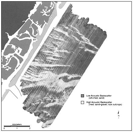
Figure 4-1a
Sidescan-sonar image of the shoreface and inner shelf off Wrightsville Beach, North Carolina, showing distinct seafloor features that have been used to document sand transport offshore several kilometers from the beach (modified after Thieler et al., 1998).
(Plate 7). Continuation of studies with the National Oceanic and Atmospheric Administration (NOAA) and other federal and state agencies concerning the distribution, magnitude, and timing of coastal and nearshore hazards (Fig. 4-2) could lead to the development of a comprehensive atlas that not only identifies coastal hazards on a national scale but also provides analyses of their magnitudes and recurrence intervals. Creation of this compilation should be thoroughly integrated among the three centers and in the short term should help in developing procedures for standardization of formats that will be so crucial in meeting
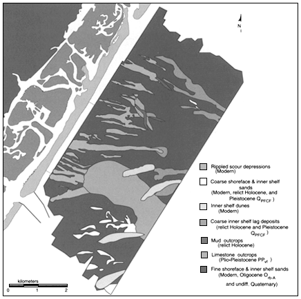
Figure 4-1b
Interpretive geological map of the shoreface and inner shelf off Wrightsville Beach, North Carolina, based on the sidescan-sonar image in Figure 4-1a, as well as seismic data, vibracores, and diver observations (Thieler et al., 1998).
the second grand challenge—development of a national knowledge bank on the geologic framework of coastal and marine regions.
Coastal Water Quality
Two aspects of water quality are important in the coastal zone: (1) saltwater intrusion into groundwater and (2) eutrophication of coastal ecosystems.
Around the perimeter of every continent and island is a coastal zone where continental (meteoric) groundwater meets seawater in the subsurface. Because of the difference in fluid density between freshwater and seawater, the interface between the two fluids extends inland from the coast in the subsurface. Global
warming is most likely to raise sea level 15 cm by the year 2050 and 34 cm by the year 2100. The effect of sea-level rise on the position of the freshwater and saltwater interface depends on the slope of the land in the coastal zone. As coastal land is flooded, the interface in the subsurface migrates inland.
Present production of groundwater and excavation of coastal navigational and drainage canals could possibly have a greater or more immediate effect on seawater intrusion than sea-level rise. Production (extraction) of groundwater that lowers the water table by 1 m, for example, can result in a rise of the interface by 40 m. The intrusion of seawater owing to coastal canals has been well documented in Florida, for example.
Eutrophication of coastal ecosystems is a serious and growing problem in the United States and around the world; for instance, oxygen-poor waters on the inner continental shelf of the northern Gulf of Mexico can extend over an area as great as 18,000 km. Other areas at risk include the Chesapeake Bay; Long Island Sound; San Francisco Bay; portions of the Baltic, North, and Black seas in Europe; and the Harvey-Peel Estuary in Australia. The geographic extent and changing severity of eutrophication, the relative susceptibility of different coastal ecosystems, and the most effective nutrient control strategies are highly uncertain because appropriate monitoring and supporting research are lacking. Uncertainty exists not only in the scientific understanding of eutrophication but also in how to translate existing and future knowledge into good control eutrophication policy.
Effective management must integrate knowledge of the oceanic, estuarine, and watershed processes that contribute to eutrophication. The overall role of coastal geomorphology and the geologic processes that shape it, as well as the role of contaminated coastal groundwater in eutrophication, may be important in understanding why certain estuaries seem to be more susceptible to nutrient pollution and eutrophication. Furthermore, the role of suspended sediment in stressed estuaries must be further evaluated before efforts to reduce nitrogen and phosphorous loading can be expected to yield anticipated benefits.
Continental Margin Habitat Mapping and Changes
The Magnuson-Stevens Fishery Conservation and Management Act as amended by the Sustainable Fisheries Act of 1996 contains essential fish habitat provisions and mandates a supporting research effort to: 1) describe and identify essential fish habitat; 2) identify and evaluate actual and potential adverse effects on essential fish habitat, including fishing-related and non-fishing-related impacts; and 3) develop methods and approaches to conserve and enhance essential fish habitat. Unfortunately, relationships between bottom character and processes and living marine resources have been established only in a rudimentary way for relatively small areas and specific sites. No methods have been devel-
oped to apply any of these rudimentary relationships to areas beyond those studied. Finally, there is little understanding of either natural or anthropogenic impacts on the relationship of the seabed to living marine resources.
The NOAA is compiling a national atlas of coastal habitat distribution and change. This undertaking, however, does not reflect the geologic context of the setting that in many instances controls the rate of change. Rates of uplift and subsidence, sediment type, magnitude of processes, and many other variables being compiled by CMGP could indeed enhance this effort. In addition, characterizing the nearshore bottoms that provide the substrate for marine organisms and their habitats would be a natural addition to the NOAA compilation. This integration would allow scientists at all three centers to expand cooperation with another federal agency tasked with providing information about coastal habitats.
Overall
Refocusing the existing program to address a few major issues will require a reallocation of funds and the phasing out of some ongoing research over the next few years. The committee decided not to identify those programs that should be phased out, but it strongly urges CMGP management to concentrate its research efforts and reallocation of funds on a more focused research program, realizing that the near-term focus of the program may change periodically to reflect shifting national and regional priorities. At present, the subset of critical issues identified above seem to be those most appropriate to the overall mission of the CMGP program. For the next few years these issues should be an integral component of the strategic planning process and should form the basis for a focused research program common to all three centers. Changing the near-term focus during a long-term effort to address the grand challenges is an important consideration. CMGP will need to select near-term focus projects carefully so as to not become overly focused on near-term issues. One mechanism to avoid over emphasis on issue-driven projects could be to give funding priority to projects that can demonstrate a potential to address near-term issues while providing an understanding of key components of the geologic framework. In addition, the committee suggests that the concept of fundamental studies be preserved and that funding be maintained at the present level of roughly 10 percent of project funds (Fig. 2-1b). A suite of well-selected fundamental studies should provide CMGP with the flexibility required to address unanticipated changes in national and regional needs for scientific information. These fundamental studies, therefore, should not be directed at existing issues. Rather, they should represent an opportunity for curiosity-driven research, especially research relevant to the CMGP long-term goals.
ROLE OF CMGP IN THE FEDERAL GOVERNMENT
Although several federal agencies conduct physical science and engineering programs and studies, the CMGP occupies a unique niche by providing capabilities to conduct research and assessments of the geologic processes impacting the nation's coasts. The efforts of the U.S. Army Corps of Engineers are focused on developing engineering solutions to very site-specific coastal problems (e.g., tidal inlet improvement and beach nourishment projects). NOAA's needs for geologic information to address its mission requirements for management of fisheries, sanctuaries, and other coastal resources are not met in NOAA, although the Sea Grant Program does support small geologic research studies conducted by state institutions. The U.S. Federal Emergency Management Agency and the U.S. Environmental Protection Agency rely heavily on the academic community to provide whatever geologic research and knowledge base the agencies require. However, the USGS alone has the ability to frame coastal geologic questions having both regional and national perspectives, while conducting studies that provide the geologic component for interdisciplinary approaches and useful information to decisionmakers. Examples of such efforts include erosion of the southwest Washington coast; Florida Bay information on injection well flushing (Box 2-4); the threat posed by contaminated sediment along the coast of southern California (Box 4-1); and seafloor characterization for essential fish habitat, including coral reef processes.
CONFIRMING THE NICHE FOR CMGP
Collaboration with Federal Agencies
The special expertise of the CMGP in understanding the geology of the coastal oceans lends itself to collaboration with other federal agencies, and some local efforts relating to ecosystems assessments and geologic framework for pollution studies with NOAA, the U.S. Army Corps of Engineers, and the Environmental Protection Agency are being conducted now (e.g., Stellwagen Bank/ Boston Outfall, New York Bight dump sites, and Lake Pontchartrain). There is a need for expanded efforts by the USGS to quantitatively describe and model the geologic framework of coastal and marine regions for more effective management of environmental protection and resources. Such collaboration with other federal agencies provides an opportunity for the USGS to leverage its program funds and to amplify the scientific return of investigations carried out by other agencies. The CMGP should develop a more aggressive approach to collaboration with federal agencies that need information about the geologic framework to meet their mission, including efforts to educate these agencies about the relevance of the information.
|
BOX 4-1 PALOS VERDES PROJECT Historic discharges from the Los Angeles County Sanitation District's ocean sewer outfall contained significant quantities of dichloro-diphenyl-trichloroethane (DDT) and polychlorinated biphenyls (PCBs). Contamination from these discharge is present at high levels in a sewage effluent-affected sediment body on the continental shelf and slope south of the Palos Verdes Peninsula, southern California (Noble et al., 1996; Wong, 1996; Drake, 1996; Lee et al., 1996). The U.S. government and the State of California are suing the parties allegedly responsible for the damages produced by this contamination. The U.S. Geological Survey (USGS) was asked by the National Oceanic and Atmospheric Administration (NOAA) (lead agency for the Natural Resource Trustees, a group that includes the State of California, U.S. Department of Interior, and other agencies) to conduct a study that would provide information for use in the Palos Verdes lawsuits. Two types of information were requested: (1) maps of the present character and distribution of contaminated sediment on the Palos Verdes margin (Fig. 4-3) and (2) model predictions of how the contamination levels will change in the future. This information complemented other biological, economic, and remediation studies being conducted. To meet this request, the USGS mobilized a major study that included remote sensing, sediment sampling, laboratory analysis of samples, in situ environmental monitoring, and state-of-the-art sediment transport modeling. Results of these studies were reported in expert witness reports and will be presented in a special issue of a research journal. CMGP staff focused on familiar areas, and outside investigators from universities and industry were brought in to handle other parts of the study. USGS scientists authored the umbrella expert reports, whereas appendixes to the reports were authored by all of the major participants, including USGS and university and industry scientists. The U.S. Department of Justice is coordinating the overall lawsuit. USGS scientists are presently delivering depositions in the Palos Verdes lawsuit. The USGS data form a major part of this case, one of the largest environmental lawsuits in the country today. Others are also using the data in development of remediation plans. |
Collaboration with State Agencies
Existing efforts to collaborate with state agencies and municipalities are important and appear to have been successful. The information provided to the states by the USGS appears to have been used to great advantage to make resource decisions and to establish and update resource management policies (e.g., Boston Harbor Outfall location, Palos Verdes outfall, Florida Bay groundwater, and southwest Washington coast). It is imperative that the CMGP expand these efforts into regional assessments of the geologic framework of coastal and marine regions. This information is fundamental to the understanding
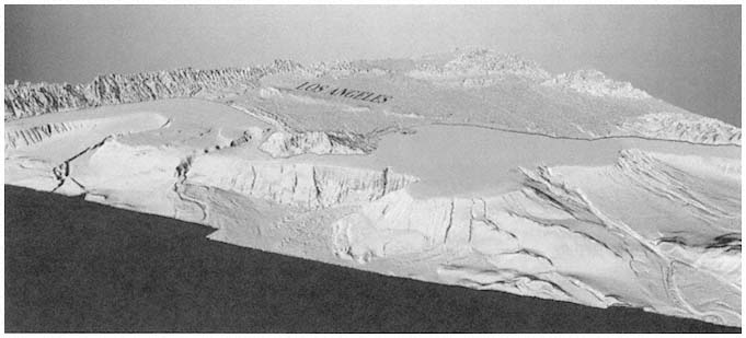
Figure 4-3
Seafloor map of the continental margin of Los Angeles. The U.S. Geological Survey is using new technology to map U.S. offshore areas. The resulting maps can help researchers and resource managers assess earthquake hazards, study movement of sediment, identify habitats, and understand the offshore environment (USGS, 1998g,h).
and prediction of natural and anthropogenic consequences to the complex coastal and marine environment.
Collaboration with Other USGS Programs and Divisions
The committee finds considerable potential for overlap between the efforts of the CMGP and other programs of the Geologic Division and the USGS (e.g., earthquake hazards, water, energy, and minerals) with concomitant lack of focused efforts in CMGP. There needs to be more substantial partnering with these programs and divisions along the lines of expanded collaboration with federal agencies. The CMGP should focus on the geologic framework questions and assessments while more specific studies are undertaken with its partners. For example, CGMP work on the stratigraphic extent of coastal formations could greatly support efforts by the Water Resources Division to understand aquifer characteristics and evaluate water resources. Along similar lines, CMGP's ability to provide a regional perspective could be essential to the earthquake hazards program in assessing the risk from earthquakes and tsunamis to coastal populations along the Washington coast. CMGP should make every effort to leverage expertise in other programs and divisions to expand its ability to meet the needs of its diverse user community.


