
The Future of Marine Geology and Geophysics: A Summary1
Marcia K. McNutt
Monterey Bay Aquarium Research Institute
The Marine Geology and Geophysics (MG&G) and Ocean Drilling programs at the National Science Foundation together spend approximately $29 million on science annually in the United States (not including ship costs). Although this is an impressive figure, increases to the program budget have barely kept up with inflation, the pool of potential investigators has been ever increasing, and other federal agencies that traditionally supported research and technology development in MG&G have had their budgets cut drastically. The net effect is a stressed research community in which innovative science, novel collaborations, and the next generation of technology development are more difficult to justify and support. Given the realities of the U.S. federal budget deficit, the financial situation is unlikely to improve in the near term. In this type of environment, there is the danger that creativity, the lifeblood of science, will become stifled in an overly conservative peer-review system unless there is some community coordination and consensus that allows bold, new ideas to be pursued. Thus the questions asked of the participants at an Ashland Hills workshop held in December 1996, were:
-
What are the most promising and exciting directions for future research in marine geology and geophysics?
-
What research strategies will best address these problems?
The workshop participants divided into four thematic groups in order to formulate their vision of where their fields should be heading in the next two decades so they could address the most pressing issues. Each subgroup identified a set of major research questions that need to be answered in order to make progress in understanding critical issues in marine geology and geophysics. Some common issues that appeared in several of the reports are:
-
The societal imperative of making rapid progress in scientific understanding of complicated, nonlinear systems. Many of the research topics central to marine geology and geophysics address issues of societal concern, such as changing climate, coastal pollution and erosion, and earthquake hazards. In some cases, there has been pressure to implement solutions to these problems without a complete understanding of these complicated systems. Even worse, some of these systems are now demonstrated to be highly nonlinear, such that input at one frequency can produce a response at very different frequencies. Human forcing may in fact lead to very unpredictable and undesirable consequences. An important area of future research will be in characterizing and modeling systems in which the input forcing is known or can be measured, and the system response can be inferred from the geologic record (geologic rime scales) or from direct observation (human time scales).
-
The central role of focused fluids in producing volcanic, tectonic, and thermal modification of the planet. Geologic modification of Earth is controlled by its fluids, whether it be water in fault zones, magma erupting on a mid-ocean ridge or island arc, plumes rising from the deep Earth, hydrothermal circulation in ocean crust and sediments, or methane deposits on continental margins. These fluids determine the locus of geologic activity and are the agents for geochemical cycling between the solid Earth and the hydrosphere and atmosphere. Quantitative understanding of the physical and chemical processes that lead to concentrations and focusing of these fluids through the lithosphere,
-
igneous crust, and sediments until their eventual expulsion into the water column or atmosphere, however, is in its infancy. We need to better understand the physical properties of the medium through which the fluids flow, the stresses acting on the systems, and their chemical, mechanical, and thermal interaction with their host rock.
-
The recognition that present-day conditions may not be representative of the whole of geologic history. A glance at the recent past shows a climate system principally forced by the eccentricity of Earth's orbit. Present-day nearshore sedimentary sequences reflect flooding of the world's shelves following the melting of large continental ice sheets, and today's seafloor volcanic activity is completely dominated by steady-state formation of new crust at the mid-ocean ridge. However, with the benefit of the geologic record, we see that just one million years ago variations in Earth's tilt were more important than eccentricity in modulating climate. During glacial maxima, sediments bypassed many continental margins through a series of canyons. In the Cretaceous, plume-type volcanism was far more important than it is today in the mass and energy transfer between the deep Earth and the surface. While in some cases, the causes of the changes in the geologic record are easily identified (e.g., rising sea level), in other cases they are not. More emphasis in the future will be directed toward documenting the various different stable states of Earth's systems, discovering what events trigger evolution from one stable state to another, and identifying the linkages between the states of very different systems (e.g., climate and tectonics).
-
The importance of explicit incorporation of effects of and on the biosphere into marine geology and geophysics. Investigators in MG&G are extremely comfortable with introducing a fair amount of physical and chemical sophistication in their science. Many have their primary professional training in these allied physical sciences. The links to biology, in comparison, are weaker and must be shored up to make progress on a number of fronts. Just as ocean chemistry cannot be understood using the principles of chemical equilibrium without taking into account biochemical cycling of nutrients, the solid Earth is modified by biologic activity from the scale of bacteria to humans. Submarine ecosystems harbor some of the most unusual and extreme examples of life on Earth, and the implications of understanding how these systems have adapted to and how they modify their environments have implications for the origin of life itself.
-
The appreciation that we must move beyond steady-state models to study geologic events as they happen. The geologic record contains evidence of many catastrophic events: earthquakes, landslides, volcanic eruptions, etc. Most of our models, however, smooth these events over time to create steady-state representations for what are really discontinuous processes such as erosion of headlands, glacial meltwater pulses, creation of oceanic crust, and filling of flexural moats. Such steady-state models distort the true impact of these events on human timescales and are useless for any hazard mitigation. Given the current lack of understanding of the temporal and spatial pattern of most geologic events, we require the technology to install undersea observatories and event-detection systems to catch geologic events in action.
-
The limitations of present funding structures and technology for problems that span the shoreline. From the standpoint of many problems in geology and geophysics, the division between the Ocean Science and Earth Science divisions at NSF is somewhat artificial. Although most of the mid-ocean ridge system is under water, sometimes it is easiest to map it where it lies above sea level (e.g., Iceland). Fluids vented along coastal margins may originate from terrestrial aquifers. Variations in sea level shift the shoreline position laterally for distances of kilometers over timescales of millennia. Ice core data from subaerial drilling can complement deep sea cores. Most efficient use of future resources will require close collaborations between land and marine geoscientists and their corresponding program officers. Even more of an impediment to working across the shoreline is lack of equipment to work near the shoreline, in shallow-water, high-energy environments. No amount of community interest in geologic processes at the oceanic margins will lead to progress unless improved technology is available for imaging, sampling, and monitoring the near-shore region.
Overall, the thematic reports, briefly summarized below, give the impression of anything but "business as usual." The community is enthusiastic about the opportunities to build new collaborations and apply new technology and expertise to find answers to the most intellectually challenging problems in marine geology and geophysics.
GROUP #1: THE SOLID EARTH
The solid Earth is continually in movement, and this movement reflects the processes of energy and mass exchange between the Earth's interior and exterior reservoirs. The current manifestations of these movements are represented by the diverse plate tectonic settings of the Earth, many of which are depicted schematically in Figure 1. This snapshot of the plate tectonic physical and geochemical circulation can also be considered conceptually as a cycle, as shown in Figure 2. The cycle begins with the formation of a new rift, followed by the opening of an ocean basin as new oceanic plate is created by spreading at ocean ridges. The aging oceanic plate is acted on by a variety of mid-plate processes such as hotspots (including seamount and island volcanism), sedimentation, subsidence, and deformation. As the plate approaches a convergent margin, it enters the "subduction factory," leading to the generation of earthquakes, release of fluids, varieties of volcanism, back-arc spreading, and ultimate recycling of residual peridotite, basalt, and sedi
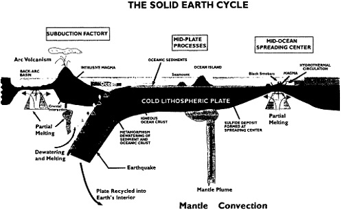
FIGURE 1 Cartoon of the solid Earth plate tectonic cycle, divided into three major tectonic components: plate creation at mid-ocean spreading centers, modification of the plate as it traverses the mantle, and subduction of the plate and creation of new crust at convergent margins. The initiation of an ocean basin through continental rifting is not shown in the figure. Source: FUMAGES (1998), p. 8.
ment into the mantle. The subduction factory is the current mode of continental growth and modification, and over time may have been the principal process leading to the creation of the continents. Ultimately the continental crust again will rift, leading to the formation of a new ocean basin, and the cycle repeats.
Each aspect of the plate tectonic cycle has a host of scientific questions that remain to be answered. These questions naturally divide according to the diverse provinces of the cycle—extending from creation of crust at ridges, to the mid-plate region, to the convergent margin. Figures 1 and 2 present these domains and some of the processes that take place in them, and the specific sections of the FUMAGES report discuss some of the outstanding questions that provide a basis for fruitful new directions for research.
There is an important additional aspect of the evolution of the solid Earth, however, that is not fully represented by Figure 1. Figure 1 is as an instantaneous view of the overall process; Figure 2 conveys the notion that not only is this view one of a continuing and repeating cycle, but also that this cycle may lead to and be influenced by the long-term geochemical and tectonic evolution of the solid Earth system. The Earth's current state is not necessarily typical of all tectonic regimes in the past. One obvious aspect of these changes is reflected in the very different apparent state of the ocean floor during the Cretaceous, when large igneous plateaus were present over much of the seafloor. There may have been major changes that have yet to be discovered, such as, perhaps, changes in the mode of mantle convection. Therefore, the study of the evolution of the solid Earth cycle through time—in all settings—emerges as or e of the clear frontiers of the science over the next decade. Old ocean floor contains one of the best records of this history.
The solid Earth cycle and its evolution through time are driven by fundamental processes that result in mass transport across the boundaries between the asthenosphere, lithosphere, hydrosphere, and atmosphere. These fundamental processes include the generation and segregation of magma, brittle and ductile lithospheric deformation, l he scales and patterns of asthenospheric flow, and the influence of fluid flow on rheology and chemical exchange between the solid and fluid Earth. In addition to its intrinsic scientific interest, investigation of these processes can eventually lead to an understanding of the causes of great earthquakes or volcanic explosions, of the generation and concentration of mineral resources, of cataclysmic events in Earth's history that have modified Earth's climate, and even of the origins of life itself.
An aim in investigations of these processors is the development of quantitative, unifying principles that govern the
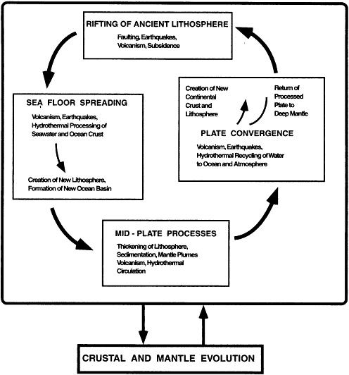
FIGURE 2 Schematic of the solid Earth cycle, beginning with rifting of ancient lithosphere, through creation of a new ocean basin by seafloor spreading, plate modification during passage over the mantle, subduction and continental addition, and continental collision, followed ultimately by another episode of continental rifting. This process through time leads to evolution and differentiation of the mantle, and mantle processes in turn influence all components of the cycle. Source: FUMAGES (1998), p. 9.
formation and destruction of the crust and mantle lithosphere, and its interactions with the hydrosphere and biosphere. Recent advances in geophysical and geochemical observation techniques, combined with the computational capability to evaluate the effects of nonlinear, open systems, have led to the development of predictive models of the mid-ocean ridge system based on simple, geodynamic parameters. Based on these advances, it seems likely that a general theory of mantle differentiation and lithospheric genesis will emerge in the next ten to twenty years. To produce this theory, we will have to concentrate research on the upper and lower boundaries of the lithosphere—the regions of interaction with the underlying convective mantle and the overlying hydrosphere and biosphere. Some of these boundaries are difficult to observe, and progress will require development of new techniques to image, for example, the base of the lithosphere in considerable detail.
Study of the seafloor provides one of the primary windows into a multitude of Earth processes, and the linkages between the various parts of the whole Earth system make the new observational data and quantitative models pertinent to a broad spectrum of Earth problems. Therefore, many of these developments will be multi-disciplinary, involving scientists from outside the oceanographic and solid Earth communities.
GROUP #2: PALEOCEANOGRAPHY
Significant advances in the field of paleoceanography have both sharpened the focus of paleoclimate and ocean history research on classic problems and initiated new research directions. The classic problems driving our long-range research program include: (1) relationships between sea level, ice volume, and climate change; (2) interactions between atmospheric carbon dioxide, climate, and its biospheric and geospheric regulation; (3) long-term changes in ocean chemical composition and geochemical fluxes as related to geological and biological evolution; (4) solar and magnetic field variability and their role in climate change and affect on cosmogenic nuclides; and (5) changes in modes of ocean circulation in relation to climate change and the evolution of oceanic basins.
Work proceeding along these paths has led to two important shifts in how we view climate that seem to cut across all time scales: (1) the growing realization that substantial changes in atmospheric CO 2 are likely to have played a large role in both long-term and short-term climate change, and (2) the discovery that nonlinear interactions in the ocean-climate system may have played a key role in determining the sensitivity of climate to both internal and external forcing. Furthermore, these nonlinear interactions can shift climatic variance to both higher and lower frequency oscillations.
In recent years, work on these classical themes has uncovered ''bombshells" that have rattled prevailing views: (a) tropical sea-surface temperatures may have been 5°C cooler during glacial maxima, in contrast to CLIMAP reconstructions with stable tropical SST; (b) evidence for cool tropics and low equator-pole thermal gradients also is found for the late Cretaceous and Eocene, again countering prevailing beliefs; (c) ice core isotope paleothermometers appear to have understated glacial cooling at high latitudes by a factor of two; (d) transitions between glacial and interglacial states can occur in only a few decades, and (e) in the late Paleocene (~56 million years ago), there was a sudden input of isotopically light carbon into the ocean-atmosphere system accompanied by global warming lasting for no more than a few thousand years. These findings have invigorated ocean-climate investigations and forced us to reexamine many traditional assumptions.
In the future, we must emphasize the search for a better understanding of processes that affect climate change and cause variability in the climate-ocean system. Through this effort we hope to gain a better understanding of the coupling of the ocean-climate system through the entire range of the Earth's climatic spectrum (Figure 3).
Examples of specific science questions that will drive research in paleoclimates include:
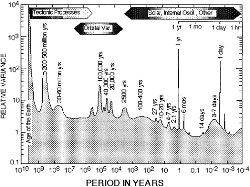
FIGURE 3 Estimate of relative variance of climate over all wavelengths of variation, from those comparable to the age of the Earth to about one hour. Shaded area represents total variance on all spatial scales of variation. Strictly periodic components of variatior are represented by spikes of arbitrary width. Modified from Mitchell, Jr., J.M. 1976. An overview of climate variability and its causal mechanisms. Quaternary Research 6:481-493, with permission from Academic Press, Inc.
-
What is the cause, nature, and range of climate and ocean variability at the inter-annual to millennial time scale given that there is no obvious external forcing?
-
What processes set the sensitivity of the climate system to external (orbital) forcing, and what processes are responsible for the long-term evolution of this sensitivity?
-
Why are there ice ages in Earth history?
In order to address these questions, integrated model, laboratory, and data studies are essential. The modeling of processes at all levels of complexity—from simple box models to more complex models of mass balance exchange in the ocean-climate system—can provide useful insights into the nature of these processes. Opportunities for model development, including climate, ocean, and biogeochemical models, and accessibility of various types of models for research must be maintained.
Collaboration between researchers across all subdisciplines that study Earth system history must be encouraged and developed. Advances in the field via data-model integration may arise from collaboration of subdisciplines that are not traditionally combined. A critical element of such collaboration will be to have an interdisciplinary peer-review process for interdisciplinary proposals.
GROUP #3: SHELF AND SHOREFACE SEDIMENTS
The coastal-shelf system of the oceans is a critical environmental interface—a fundamental Earth discontinuity— where terrestrial, marine, and atmospheric processes converge and mutually influence one another across a spectrum of spatial and temporal scales. Society relies on the coastal system for its rich biological diversity, extensive mineral resources, and its fulfilling scenic and recreational opportunities. This system satisfies needs for waste disposal, transportation, and a climate moderated by the heat engine of the oceans. It is these attributes that have led to a massive increase in population along the world's shoreline, a pattern that has stressed available resources and exposed development to marine hazards.
Media reports of storm damage, sea-level rise, coastal erosion, and declining nearshore water quality sound a clarion call from the American constituency for the development of a scientific focus on the nation's shelf and shoreface system. As we dam rivers, armor coastlines, disperse pollutants, and mine the shoreface we are forever altering the flux and partitioning of sediments through a sensitively linked series of littoral and marine ecosystems. Human alteration of the coastal system, in fact, constitutes a series of large-scale experiments that are disturbing the natural variability of the environment. Unfortunately, we take these actions without a full understanding of the fundamental processes that provide for the natural health and viability of the afflicted system.
-
How do human actions impact natural variability?
-
What are the fundamental processes that unify the multiple temporal and spatial scales constituting the dynamic behavior of the shelf and shoreface?
-
Are there overarching physical/biochemical processes governing natural variability in the spectrum from microseconds to millennia?
These fundamental and fascinating questions can only be answered with multi-disciplinary and multi-scale investigations of sedimentary dynamics, and resulting environmental and stratigraphic imprints, across the land-sea interface of the continental and insular margin.
Investigations of sediments at the ocean margin range widely in both the time scales of the processes considered and in the spatial scales of the resulting morphologies or stratigraphic record. One investigator might obtain measurements of orbital velocities under waves in the nearshore, and relate those to the resulting transport rates of sediments or to the dimensions of ripple marks formed on the bed. Another investigator could be considering the processes of tides on the mid-shelf and the formation of huge sand waves. Longer time scales and larger spatial considerations apply to the investigator who relates the cycles of sea-level change to the resulting stratigraphy or architecture of deposits that span the entire ocean margin, crossing the shoreline and extending onto the coastal plain.
This breadth of consideration is illustrated by the accompanying diagram (Figure 4) that graphs the time scales of processes (dynamics) versus the scales of the sedimentary features (morphology). In the dynamics domain, the shortest time scale is represented by the rapidly-fluctuating turbulent eddies within currents that are important to the entrainment and transport of sediments. Beyond that are the variations due to wind-generated waves that generally range between 5 and 20 seconds, and the hourly changes in water levels due to fides and the associated currents they generate. Also important are the occurrences of storms, where "normal" storms generally occur a few times each year at a specific coastal site, while a "major" storm such as a hurricane may occur only once in a decade or longer. Such storms have profound effects on the sediments of the nearshore, and even on the seabed sediments across the entire shelf.
Even longer time-scale processes shown in the accompanying diagram are represented by sea-level variations. Tide gauges along our coasts provide a record of relative sea-level change during roughly the past 100 years, the change in global sea level "relative" to the land. Sea-level change can also include punctuated, millennial-scale sea-level events due to shifts in global ice volume (these may influence shelf sediment exchange and seafloor morphology during periods of rapid global change), and transgression/regression cycles that have occurred with glacial-interglacial changes in Earth's climate (Milankovitch cycles). Of critical interest is the knowledge gained from investigations
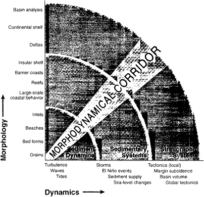
FIGURE 4 The dynamics and morphology of sedimentary environments prescribe specific regions of the morphodynamical corridor that tend to define the extent of our research efforts. Workshop members believe that better communication among and between regions along the corridor will enhance the progress of marine sedimentary research.
Source: FUMAGES (1998), p. 52.
of the Holocene and last interglacial episodes of transgression. These are specifically important since they have been profoundly influential in governing the present configuration of our coastal plains, coasts, and shelves. The longer-term processes included in the graph are the tectonics of crustal movement at the coastal interface, processes such as continental margin subsidence, changes in basin configuration, and global tectonics that govern the degree of continental freeboard and the fundamental timing of shelf evolution.
The second axis of Figure 4 shows the spatial scales of sedimentary features involved in research investigations. This list is only suggestive of the range of scales and is not an exhaustive account of the many sedimentary bodies found at the ocean margin. At the smallest scale are the sediment particles, obviously important in studies of sediment transport, but also important in the record of grain-size distributions of particles within the resulting deposits that reflect the transport processes. Accumulations of sediment grains form sand ripples or the bars that are an important part of the overall beach morphology, or the large-scale sand waves found in some shelf environments. These morphological features combine to form the entirety of deltas, estuaries, barrier islands, and the present-day shelf. Recorded within the sediments of the margins are ancient shelves, stranded sand bodies, fossil reef tracts, and a stratigraphic record of former changes in sea level.
To a degree, individual research efforts can be placed within the temporal-spatial scale of the accompanying graph. These tend to congregate along the 45° zone shown. For instance, investigations of sediment-transport processes focus on the time scales of waves and currents and down to the scale of turbulent fluctuations, while considering the movement of sediment grains and the effects of sand ripples on that transport. Other investigators document the response of beach morphology to the occurrence of storms, or the formation and migration of sand waves on the continental shelf where sediment transport is due to tidal currents. Yet another group of investigators is focusing on the effects of sea-level change, with the impacts ranging from the present-day changes in coastlines and estuaries to the long-term record within the stratigraphy of the continental margin. The unique ratio of morphologic and dynamic integration that constitutes research on the shelf and shoreface falls within this "morphodynamical corridor."
There is a notable lack of continuity and overlap among separate groups that study discrete morphodynamical ranges. A challenge to our science is to improve the linkage among these research subdisciplines. We must learn to talk to one another more often, and more effectively. Any one investi
gator tends to be limited to a small range of time scales of processes and resulting spatial scales of sedimentary features. The investigator is familiar with the next lower time-space scale of research, since his/her investigation likely uses the tools of that research (i.e., sediment-transport equations) or relies on its conclusions; the investigator is likely also aware of the implications of his or her research to the next higher time-space scales. While it is seldom that an individual can meaningfully cover an appreciable area of the time-space graph, it is through collaborative research efforts and modeling that connections can be made that lead to a more comprehensive understanding of the processes that are presently important, and were important in the past, to the sediments and sedimentary record of the margin system. A deeper understanding in the future will therefore depend on increased support for such collaborative research efforts.
As we enter the twenty-first century, seventy percent of the world' s population will live and work alongside the sedimentary province of the ocean margins. The deposits of the coastal plain, shoreface and shelf, slope, and rise consist of particles and pore fluids arranged in a complex architecture of bedforms, layers, wedges, aprons, and lenses that define the anatomy of the province.
For over a century, human activity has perturbed the coastal sedimentary province by the filling of wetlands and the reclamation of estuaries, through the construction of sea-walls and breakwaters, and by starvation of the sediment supply as a consequence of damming rivers for hydroelectricity, irrigation, and flood control. Many of the environments of this province are "diseased" from thoughtless use, over-exploitation, and even well-intentioned but ignorant attempts at mitigating the problems that come with human influences. Millions of dollars are spent annually to pump sand back to the shore to replenish beaches, only to have these grains disappear into the sea again following northeasters, hurricanes, or typhoons. Much of this province has been alternately submerged and exposed in the past. Some of it will experience renewed flooding if global warming predictions are correct. Some sectors, such as the extremely populated Nile Delta and portions of the Mississippi Delta, are currently in a state of crisis in the wake of severe coastal erosion. The megalopolis of Bangkok is sinking at an alarming rate of one meter in a human lifetime due to a combination of diminished sediment supply and aquifer depletion.
True stewardship of the sedimentary resource will require an improved understanding of its anatomy. The piecemeal, ad hoc examination typical of past research will not provide a sufficiently integrated understanding of the character of the system. A new approach must incorporate the next generation of Earth and environmental scientists trained with greater engineering skills and an integrated knowledge of the physical/chemical/biological metabolism of the sedimentary environment. This is necessary preparation for the challenge of quantitative modeling and measurement that lies ahead. A new, integrarive science must be the hallmark of future sedimentological research. In order to achieve new goals of understanding the ocean margin, the science of sedimentology must evolve into a systems approach that integrates theories and concepts of biochemistry, geophysics, meteorology, climatology, population statistics, ecology, and hydrodynamics.
GROUP #4: FLUIDS IN THE OCEANIC LITHOSPHERE AND MARGINS
The importance of water to essentially all aspects of Earth science probably cannot be overstated. Water is a ubiquitous agent of geological creation and transformation and of life. The charge of Working Group 4 was to construct a vision for the next 10+ years of marine geological and geophysical research involving fluids, fluid processes, and fluid products. This vision is to include an assessment of the most important unresolved questions, the means by which these questions should addressed, and the infrastructure and facilities that will be required to do so. The completion of our assignment was complicated by the nature of fluids themselves: they exist at an astonishing array of temperatures, pressures, chemistries, and physical properties, within many different geological systems.
While many questions associated with lithospheric fluids may be addressed successfully through the use of steady-state assumptions, it is becoming increasingly clear that fluid flow and associated processes and properties are inherently transient and interdependent. We suggest that issues associated with fluid flow and resulting reactions, chemistry, biology, and physical properties can be considered in the context of conservation of mass and conservation of energy. The simplest example of this concept is illustrated through examination of the one-dimensional, steady-state diffusion equation (used for chemical, thermal, electrical, and fluid transport): q =-D dP/dl. This equation states that the flux (q, mass or energy) is a function of the driving force (dP/dl , a gradient in potential) and the properties of the system that govern transmission (D). If one knows any two of the above terms, the third can be calculated. Ideally, all three would be determined independently so that internal consistency can be established.
Other modes of transport can be described in such an equation through inclusion of additional terms (advective, dispersive, reactive, decay, etc.). When such a construction is applied to a volume of the oceanic lithosphere or margin, multidimensional and transient processes can be considered, including the importance of storage terms (for both energy and mass) and tensor properties. With this framework in mind, key questions can be considered:
-
What are the mechanisms influencing hydrothermal fluxes associated with dike injection, transient magma chamber output, and penetration of a cracking front (extent of water-rock reactions, creation and modification of fluid pathways).
-
What is the flux-frequency distribution for ridge-crest hydrothermal activity (heat, fluid, chemistry)?
-
To what depth and to what crustal age does significant ridge-flank hydrothermal circulation extend, and what is the influence of this flow on crustal evolution and ocean chemistry?
-
What are the roles of fluids in the earthquake cycle?
-
What role does fluid flow play in gas hydrate accumulation and how important are hydrates to climate change, slope stability, and energy resources?
-
What are the extent and consequences of interactions between terrestrial ground water and marine systems (fluxes, diagenesis, biology, slope stability, canyon formation)?
-
How much of a role does the microbial community play in subsurface chemical and physical transformations?
These, and a host of other exciting questions, remain mostly conjectural as there have been few quantitative microbiological studies specifically addressing these geological and geochemical problems. We therefore recommend that a small series of highly-focused studies be carefully prepared and executed, within several distinct seafloor environments, as soon as possible. The initial experiments should provide first-order information that will allow an assessment as to whether a significant initiative, and concentration of resources, is justified for more complete, long-term exploration of subseafloor microbial communities.
COMMON THEMES IN INFRASTRUCTURE
The main goal of the workshop meeting was to identify the important scientific questions that would be driving research in marine geology and geophysics in the next 10 to 20 years. However, it was not possible to discuss the science that we wish to accomplish without mentioning the new equipment or changes in the funding infrastructure that would either facilitate or enable researchers to address these questions. Some of these needs are pointed out directly in the thematic group reports, but others are so overarching that it made more sense to call them out in this separate section.
Common Use Equipment
Marine geology and geophysics is an observationally based science and will continue to rely on ocean-going observational capabilities. A significant amount of the technology used in MG&G studies is needed by a wide spectrum of the community (e.g., high resolution seismics for paleoceanographic, geohazard, and sediment processes studies; equipment to sample fluids and sediments; moored arrays for long-term observations for fluid and ridge crest processes; geophysical imaging equipment for studies of lithospheric and mantle dynamics, etc.).
The present funding model for much of the "common use equipment" has resulted in a gradual degradation of many MG&G capabilities. It is not unusual for equipment systems to be maintained as part of a specific ship operation. In some cases, systems are supported as independent cost centers. In either case, a use hiatus results in system degradation, loss of technician expertise, and ultimately a complete loss of the system capability. This problem affects "standard" shipboard equipment as well as portable equipment.
We recommend a community-wide effort to come to a consensus about (1) what instrumentation is broadly needed; (2) how it should be maintained and managed in a way that is appropriate for each facility; (3) how to build in appropriate funding feedbacks so that outdated or poorly managed equipment pools are discontinued and new instrumentation can be added; and (4) what funding structure best supports this equipment. While there will be some short-term costs associated with development of a reliable instrument pool that will be available to the community, in the long run, a cost-effective solution to the problem of deteriorating and unreliable facilities is essential to the health of marine geosciences.
The list of equipment that might be candidates for a shared pool is large: MCS equipment, ocean bottom seismometers, new-generation magnetometers and gravimeters, coring and sampling devices, autonomous underwater vehicles, tethered vehicles, submersibles, etc. We discuss below just a few of these capabilities that we believe are good candidates for placing in a common-use facilities pool.
Navigation
There is a general need for a community-supported facility to (1) position ships, water column instruments, and seafloor instruments in a relative reference frame with a precision of several meters; (2) position ships and instruments in an absolute reference frame with a similar accuracy; and (3) have this information available on the bridge and within scientific facilities in real time. This capability has significant implications for work across the full range of geological environments and scientific problems. Traditionally, precise navigation in a relative frame has been accomplished with a combination of seafloor transponders shipboard and relay transponders, and shipboard computer hardware and software (long-baseline navigation), all of which must be provided and integrated with the shipboard environment by a project investigator, team member, or consultant. Differential or P-code GPS similarly has not been routinely available, although this situation is changing aboard the larger UNOLS ships. Experience has proven that many scientific programs are difficult or impossible to complete without precise navigational capabilities. In addition, the captains and mates of ships of all sizes are much better able to locate and hold target positions (for both ships and instruments) when they get direct graphical feedback of relative and absolute locations. This capability should be made broadly availability within the MG&G community, and support capabilities
(including personnel) should be established for the installation and use of this equipment.
Geophysical Arrays
To address a wide variety of problems in marine geosciences large, portable geophysical arrays of ocean bottom seismometers, magnetometers, and electrometers will be required. Short period geophone and hydrophone instruments will be required in large numbers (e.g., 500) for both active and passive tomography experiments, and for monitoring of microseismicity in tectonic settings ranging from mid-ocean ridges to mid-plate hotspots to the accretionary wedge above a sub-ducting slab. These instruments need to be relatively inexpensive to build and operate, and should be capable of deployment times of up to a year. A smaller number (ca. 50) of portable broadband seismometers will be required for long-term teleseismic tomography studies. All of these instruments must be openly available to investigators throughout the geosciences community. Related to this is a need for shallow-water acoustic mapping instruments of high precision in order to conduct change detection experiments for capturing and quantifying dynamic seabed processes that imprint the sedimentary record. The shallow marine community could also benefit from shared pools of pressure sensors, current meters of various types, optical back-scattering devices, high resolution down-looking in situ seabed mapping tools, and the data logging and power units necessary to support such arrays.
Unmanned Vehicles
Tethered and untethered unmanned underwater vehicles have already demonstrated their value in geophysical surveys. They extend the capabilities of conventional surface ships by expanding the area that can be monitored in both time and space and by providing close-up views of events and structures on the seafloor. Advances in technology and design now promise vehicles that are lighter, cheaper, and consume less power. In the future, cost-effective and realistic strategies for underwater event detection and temporal monitoring of systems will likely take advantage of autonomous underwater vehicles (AUVs) and remotely-operated vehicles (ROVs). It is not too soon for the scientific community to begin thinking about how to make these capabilities broadly available and how to manage such a facility. Emphasis should be placed on building some standard "bus" design that can be equipped with mission-specific sensors, without discouraging design improvements in this rapidly evolving field of ocean engineering.
Ocean Drilling Facilities
All thematic groups identified some form of ocean drilling (ODP-like) capability as a long-term requirement of their sampling and sometimes their monitoring strategies. Sampling and monitoring down-hole conditions in 100-1,000 m sections of zero-age basalts is a priority for both the solid Earth and fluids groups. The solid Earth group also needs sampling capability into older oceanic crust that may eventually require riser capability for deeper sampling. Subduction zone problems require standard ODP capability for flux balance experiments, and riser capability for investigations of the seismogenic aspects of subduction zone systems. The sediments group requires standard ODP capability in a wide variety of sedimentary environments, and in addition, a shallow-water jack-up rig capability. Deep sampling of the thick sedimentary and volcanic sequences of passive margins probably will require riser drilling capability. Paleoceanographers require hydraulic piston coring and good recovery capabilities in a wide variety of lithologies. In particular, they require improved recovery capabilities in difficult sequences such as cherts/chalks and coral.
Archives
The productivity of the entire MG&G community has been greatly enhanced since the introduction of archiving facilities for underway geophysical data and ODP cores. In contrast, there is no uniform archiving procedure for rock samples. These samples retrieved from dredging and submersible operations are a critical long-term resource with which to explore new ideas using ever more sophisticated analytical techniques. Although NSF requires samples to be made available by principal investigators after two years, there is no formal mechanism to implement this requirement, nor any clearly defined long-term repository available and accessible to the entire MG&G community. Repositories at several institutions are beginning to serve this need, but a long-term financial commitment to a sample archive would be beneficial. In addition, we need to encourage investigators to place carefully documented and packed samples into this archive.
Education and Public Relations
Public awareness and support for science, which has always been highly desirable, has become essential in the current national fiscal climate. Furthermore, the science education of the American population is an important part of NSF's federal mandate. We recommend that the Division of Ocean Sciences take a more active role in communicating the excitement of cutting edge scientific discovery to the public. It should be recognized that to be effective a sustained, focussed, long-term effort to develop the needed expertise and experience within NSF and within the science community will be required. Various models for this education and outreach activity should be examined, but one possibility is to work through a publicity office at JOI or CORE. We believe that the costs of such an effort, if it were
effective, would be highly worthwhile for the long-term public support of our science.
Some specific educational outreach activities that could be highly effective include:
-
The creation and maintenance of Web-site-based learning sites shared among institutions or agencies. NSF could support the development of teaching modules (electronic workbook) of current oceanographic concepts (e.g., El Niño) for primary and secondary school teachers that would include concise description of the scientific concepts, "classic" data that can be downloaded and manipulated by students, and a list of related projects and reading.
-
A program to support lecture to students in primary and secondary schools by graduate students.
-
Participation of high school teachers in seagoing cruises. Science teachers represent a large reservoir of well-educated, scientifically aware communicators who uniformly welcome the exposure to scientific experiences. They enthusiastically transmit their experiences to their classes. They also interact with the parents of their students, their schools, their districts, and the general public. As a result, including teachers in field studies provides a major multiplier of the research experience. CORE could serve as a center for publicizing this program, and as clearing house for teachers wishing to join a cruise.
WORKSHOP PARTICIPANT LIST
I. Solid Earth
Continental Margins
Dixon, Jacqueline (Univ. of Miami)
Goldstein, Steven (Lamont-Doherty Earth Observatory [LDEO])
Plank, Terry (Univ. of Kansas)
Taylor, Brian (Univ. of Hawaii [UH])
Mid-Plate
Farley, Ken (California Institute of Technology)
Hauri, Erik (Carnegie Institution of Washington)
Larson, Roger (Univ. of Rhode Island)
McNutt, Marcia (Massachusetts Institute of Technology [MIT])
Rifting
Detrick, Bob (Woods Hole Oceanographic Institution [WHOI])
Kelemen, Peter (WHOI)
Langmuir, Charlie (LDEO)
Lonsdale, Peter (Scripps Institution of Oceanography [SIO])
Morgan, JP (SIO)
Orcutt, John (SIO)
Parmentier, Marc (Brown Univ.)
Sawyer, Dale (Rice Univ.)
Sinton, John (UH)
Solomon, Sean (Carnegie Institution of Washington)
Tréhu, Anne (Oregon State University [OSU])
II. Climate
Arthur, Michael (Pennsylvania State Univ.)
Boyle, Edward (MIT)
Curry, William (WHOI)
Delaney, Peggy (University of California, Santa Cruz [UCSC])
Moore, Ted (Univ. of Michigan)
Raymo, Maureen (MIT)
Pisias, Nick (OSU)
III. Sedimentary Processes
Beach, Reg (OSU)
Cacchione, David (U.S. Geological Survey)
Fletcher, Chip (UH)
Ginsburg, Robert (Univ. of Miami)
Hine, Albert (Univ. of San Francisco)
Holman, Robert (OSU)
Kineke, Gail (Univ. of South Carolina)
Komar, Paul (OSU)
Mayer, Larry (Univ. of New Brunswick, Canada)
McCave, Ian (Cambridge Univ.)
Milliman, John (Virginia Institute of Marine Sciences)
Pilkey, Orrin (Duke Univ.)
Ryan, Bill (LDEO)
IV. Fluids/Deformation
Baker, Paul (Duke Univ.)
Davis, Earl (Pacific Geosciences Center, Canada)
Delaney, John (Univ. of Washington [UW])
Deming, Jody (UW)
Fisher, Andy (UCSC)
Fisk, Martin (OSU)
Kastner, Miriam (SIO)
Lilley, Marvin (UW)
Moore, Casey (UCSC)
Shipley, Tom (Univ. of Texas)
Urabe, Tetsuro (Geological Survey of Japan)
Von Damm, Karen (Univ. of New Hampshire)
Additional Participants
Claflin, Lynne (Consortium for Oceanographic Research and Education)
Dauphin, J. Paul (National Science Foundation [NSF])
Elthon, Donald (NSF)
Epp, David (NSF)
Fox, Paul J. (Texas A&M Univ.)
Haq, Bilal (NSF)
Kinder, Tom (Office of Naval Research)
Malfait, Bruce (NSF)
Morell, Virginia (Science Magazine)
Mottl, Mike (UH)
Purdy, Michael (NSF)
Sancetta, Connie (NSF)
Shor, Alexander (NSF)


