
Page 41
7—
MSU Observations
Introduction
The Microwave Sounding Unit (MSU) is a microwave radiometer that flies aboard NOAA's polar orbiting weather satellites. Each day, the MSU observes approximately 80% of the earth's surface, with the orbit shifting slightly each day so that 100% coverage is achieved over a three to four day period. To date, nine MSUs have been used operationally, forming an uninterrupted daily time series from 1979 to the present. One MSU remains in orbit as the last representative of this series, which in 1998 began to be replaced by the Advanced Microwave Sounding Unit.
The MSU observes the earth's natural upwelling radiation at four frequencies between 50 and 60 GHz. The particular channel upon which this report focuses is channel 2 (53.74 GHz). The radiation detected by channel 2 comes from the earth's atmosphere (90–95%) and surface (5–10%). The bulk of this radiation originates in the troposphere, the layer from the earth's surface up to about 10 km. The MSU also monitors the lower stratosphere through its channel 4. The intensity of radiation observed in these channels is directly proportional to the temperature of the air; hence, MSU can be used as a satellite "thermometer" for measuring air temperature.
The air temperature computed directly from channel 2 is representative of the middle-to-upper troposphere (centered about 7 km above the surface). A small but significant part of this radiation emanatescontinue
Page 42
from the lower stratosphere. This is problematical for detecting changes related to greenhouse warming, because the warming in the troposphere is expected to be accompanied by cooling in the lower stratosphere. Therefore, the blending of the radiation from these two layers seen by channel 2 partially or completely damps out any greenhouse warming signal.
There are two approaches to processing the observations to obtain a pure tropospheric temperature. One approach is to combine observations from the different channels of the MSU. The other approach is to exploit observations from the different scan angles using MSU channel 2 alone. The latter approach is the one discussed in this report because it is much more mature in terms of the extent of data-set development and validation. To obtain a temperature closer to the earth's surface in the latter approach, observations from different scan angles that the MSU uses to view the earth's atmosphere are arithmetically combined to reduce the influence of the upper troposphere and stratosphere (Spencer and Christy, 1992). The advantage of this technique is that the resulting lower tropospheric temperature (often referred to as "MSU 2LT") is closer to the earth's surface (centered about 4 km high). Because the central issue being examined in this study is the expectation by some that the lower troposphere should exhibit similar temperature trends as the surface, the panel exclusively discusses the MSU 2LT product in this report. The drawback of using the MSU 2LT product is that the retrieval method relies on a subtraction of adjacent view angles, which (a) increases measurement noise and (b) doubles the sensitivity of the measurements to surface emissions (to 10% over oceans, 20% over land) (Spencer and Christy, 1992). These effects more than double the error characteristics for MSU 2LT relative to MSU 2.
MSU Temperature Trends
The geographical distribution of MSU lower to mid-tropospheric temperature trends is shown in Figure 7.1. It is evident that the regions of rapid surface warming apparent in Figure 6.2 (e.g., Western Europe, Eastern Russia) tend to be characterized by rapid warming aloft, and vice versa. In contrast to the surface data, which exhibit a warming trend at most locations, the satellite data show roughly equal areas of warming and cooling. Whereas it is obvious from a visual inspection of Figure 6.2continue
Page 43
that the global-mean surface temperature trend is upward, the same cannot be said of the trend inferred from the MSU data; the global-mean trend may be viewed as a small difference between warming trends over some areas and cooling trends over others.
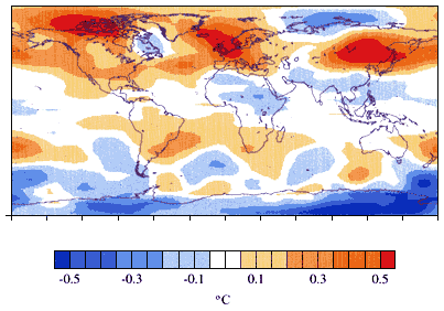
Figure 7.1
Global lower to mid-tropospheric temperature trends (°C/decade) from the MSU
version D over the 20-year period 1979–98. These ordinary least square trends are
computed from data from Christy et al. (2000).
The time series of seasonally averaged global MSU lower to mid-tropospheric anomalies is shown in Figure 2.3. The data reveal major swings in temperature over relatively short periods, which are largely the result of climate perturbations such as the El Niño—Southern Oscillation (ENSO) warming events in 1983, 1987, 1991, and 1997; the cooling events in 1985, 1988, 1996, and 1999; and the volcanic aerosol cooling events in 1982 and 1991 (Christy and McNider, 1994). Over the past 20 years, MSU observations indicate that the globally averaged lower to mid-tropospheric temperature has increased at a rate of approximately 0.05 °C/decade, as computed using the ordinary least squares statistical method. It is important to note that a single 20-year period of record iscontinue
Page 44
unlikely to be representative of both future rates of change and rates of change over much longer periods of the historical record. The reasons for this include the large natural variability associated with El Niño, together with both long- and short-term changes in the external factors that can influence climate, such as volcanic eruptions, the sun, and greenhouse gases.
Sources of Uncertainty in Trend Estimates
As with all climate data sets, there are drawbacks and limitations associated with the MSU temperatures. To begin with, MSU channels 2 and 4, as well as products derived directly from these channels, have quite coarse vertical resolution. The MSU cannot measure the temperature at a specific altitude, as is done by balloon observations. Rather, it detects a weighted average of the temperature throughout the atmosphere. This is particularly problematic for diagnosing the causes of climate change, because the different atmospheric layers may exhibit different long-term temperature trends. For example, during the 20-year period of MSU operation, the evidence is clear that the surface layer has experienced a warming trend, while significant cooling has occurred in the stratospheric layers observed by MSU channel 4.
Systematic measurement errors are another problem for the MSU. Variations in sensor gain (i.e., the ratio of the perceived signal to the actual signal) are particularly problematic in that these gain variations can be misinterpreted as trends in air temperature. In principle, gain variations can be measured (and hence corrected) by the onboard two-point calibration system, consisting of a warm load at a known temperature and cold space observations at 2.7 Kelvin. However, in practice the gain cannot be exactly determined because of the presence of small non-linearities in the MSU response to incoming radiation. It appears that this non-linear response was not properly characterized in the pre-launch thermal-vacuum tests. As a result, the two-point calibration system is not completely removing gain variations. To correct this problem, a rather elaborate post-launch analysis relies on the fact that the radiometer gain varies with the physical temperature of the front-end radiometer components (Christy et al., 2000). Systematic measurement differences between different satellites over many years are correlated with the physical temperature of the radiometers. A time-hard
Page 45
varying gain correction, which is a function of instrument temperature, is then applied to those MSUs that appear to have experienced calibration problems. This additional complexity in MSU data processing, in conjunction with a non-linear gain problem that is poorly understood, decreases our confidence in the ability of MSU to measure long-term trends. To the extent that these problems are random, they can be reduced by averaging the millions of observations (over 15,000 per day). However, residual systematic calibration errors not correlated with the radiometer temperatures cannot be removed in this way.
Systematic measurement errors also impact our ability to intercalibrate the series of MSUs. The offsets between the MSU observations from each of the satellites can be readily determined if the bias is constant, but is more difficult to determine if the satellite is drifting in orbit (see below). During periods of satellite overlap, the temperatures measured by two different MSUs are compared. Typically, a temperature offset of up to ±0.4 °C is found. Given the fact that the MSUs are nearly identical instruments, it is not entirely clear what is causing these offsets (perhaps very small manufacturing differences or satellite altitude differences). In any case, these inter-satellite offsets are addressed by adding small bias corrections to data from the various MSUs so that they are, on average, in agreement during overlap periods. This type of satellite intercalibration works best for long overlap periods (one year or greater). Unfortunately, in the case of the NOAA-9 MSU the overlap period was only 102 days. To bridge the NOAA-9 period, several different adjustment methods were tested (Christy et al., 1998). These methods produced a spread in trends of about 0.1 °C/decade. The method that produced the lowest error characteristics and the most data available for analysis was chosen. This selected method also had the desirable feature of producing a decadal trend that was close to the mean of all other possible methods. Nevertheless, the relatively small number of observations during overlapping periods in 1986–87, coupled with uncertainties arising from the choice of method used to correct inter-satellite biases, introduces a further source of uncertainty in MSU-based estimates of decadal-scale trends.
Aside from the issue related to the method chosen for merging the satellite data, there is also an uncertainty associated with determining each satellite's bias relative to some reference value. Several tests have been performed in which the biases were calculated from separate subsections of the overlapping periods, demonstrating very highcontinue
Page 46
reproducibility of the results. Even so, small inter-satellite bias errors can accumulate in such a way as to introduce errors in the long-term trend.
Even in the absence of measurement error, the drift of the satellite orbit has the potential to introduce spurious signals into the MSU temperature trend. One component of orbit drift is the decrease in satellite altitude that occurs after launch. Fortunately, this effect can be precisely modeled using the satellite orbital data and a relatively simple radiative transfer model. However, it is worth noting that this particular effect, known as orbit decay, was not recognized until quite recently (Wentz and Schabel, 1998), which suggests that there may be other subtle but important corrections that still need to be applied. The other component of orbit drift is the change in the local time for satellite observations. As the satellite slowly drifts in time, it will observe a warming or cooling trend simply due to the change in time of day being observed on earth (night is cooler than day). If no correction is applied, then this diurnal signal will be confused with an interannual signal because the diurnal drift is on time scales of the order of 0.5 hr/year. As was the case for the radiometer gain problem, a complex analysis is required to remove the diurnal drift signal. In Christy et al. (2000), the effect of the diurnal drift is estimated from the difference between the left and right sides of the MSU viewing swath, which represents a difference in local time ranging from over one hour in the tropics to several hours at the poles. This procedure attempts to remove most of the diurnal signal, but some error will remain. The preceding discussion of problems addresses each individually, whereas in practice these problems are not necessarily independent (for example, a bias that is changing with time), increasing the uncertainty of the corrections.
In light of the aforementioned problems, the obvious question is how accurately can MSU measure long-term trends. This is a difficult question to answer. The errors associated with radiometer gain, inter-satellite calibration, and diurnal drift are difficult to model, and there is always the possibility of other, yet to be found, effects.
The most recent version of MSU 2LT, which includes adjustments for orbital changes, instrument heating, and changes in diurnal sampling, is referred to as version D, distinguishing it from earlier versions labeled A, B, and C. Over the entire time series, the adjustments to version D relative to version C affect the trend of version C as follows: (1) orbit decay, +0.10 °C/decade; (2) diurnal drift, -0.03 °C/decade; and (3)continue
Page 47
instrument body effect on several instruments, along with the impact of new NOAA-12 calibration coefficients, -0.04 °C/decade. The net effect therefore is +0.03 °C/decade of version D versus version C.
The time series of globally averaged temperatures from versions C and D are compared in Figure 7.2 together with the difference time series (D minus C), which represents the correction to version C. During individual seasons, the corrections amount to as much as a few tenths of a degree C. The spikiness in the difference between C and D in post 1991 data is due to the erroneous calibration coefficients used in version C, discovered by Mo (1995), and corrected in version D. The upward trend in the corrections, which amounts to +0.03 °C/decade, is evident from a visual inspection of the difference time series in Figure 7.2. The cumulative effect of all the corrections that have been made to the MSU data since the release of version A also amounts to +0.03 °C/decade.
Consistent with the recommendations of this report that independent processing efforts should be undertaken, a separate MSU time series has been created by Prabhakara et al. (1998). This data set is based on a small portion of the MSU channel 2 data, with no adjustments for the effects described above. In many ways it is similar to the Spencer/Christy MSU 2 version A. However, the data set has yet to be completed for 1979–98, and has not been compared with other data sets in detail for assessment purposes.
Because there is only one set of observations and a limited number of processing efforts, there is no rigorous way to objectively compute the MSU's measurement precision. However, assessments can be made of the effect of perturbing the methodology, as well as the assumptions that are used to compute MSU temperatures. One analysis of this type, which also included direct radiosonde comparisons, suggests a measurement error of ±0.06 °C/decade14 for the MSU trend (Christy et al, 2000).continue
14 This particular value was derived from three separate calculations. (1) The 95% error estimate for each of the three correction procedures was determined and applied to the data. Then the year of worst reproducibility was identified (i.e., to create a conservative estimate). The magnitude of this error was applied to all years (i.e., each year had an error bar with which the 95% trend range could be determined.). (2) Using co-located radiosonde and MSU differences on 2.5-degree grids, error estimates were calculated for regions and then scaled globally in a conservative manner by assigning all error to MSU (because these were stable, U.S. controlled stations). (3) Using two different global radiosonde data sets, error estimates were derived. The value ±0.06 °C/decade encompasses the 95% range from these three methods of estimation. However, this estimate does not include testing either of the sensitivity of the period analyzed, or of the substantial uncertainty associated with adjustments to the data from NOAA-9.
Page 48
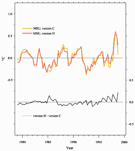
Figure 7.2
Globally averaged time series of lower to mid-tropospheric MSU temperature
anomalies from version C (orange curve; Christy et al., 1998) and version D (red
curve; Christy et al., 2000), as well as the difference between versions D and C (D-C)
(gray curve, bottom) from 1979 to 1998. To highlight the differences between the curves,
the vertical scale has been expanded by 50% relative to the report's other MSU time series figures.
Page 49
Others, however, view this analysis as not rigorous enough to reliably identify measurement error at the precision required for decadal-scale climate monitoring, and estimate the measurement error in the MSU trend to be about ±0.1 °C/decade (Hurrell and Trenberth, 1998), or possibly greater.break


