
2
Mine Warfare: An Overview
The naval mine is an efficient force multiplier and is one of the most cost-effective weapons in the naval arsenal (Table 2-1). Mines are small, easy to conceal, cheap to acquire, require virtually no maintenance, and can be easily and simply laid from almost any type of platform. Naval mines can be used to deny hostile forces access to the coastal zone and to defend important targets, such as ports, anchorages, and offshore structures, from amphibious or seaborne attack. Mines can quickly wipe out, or seriously impair, the effectiveness of surface and submarine forces. Emplaced mines are also difficult to counter and neutralize, especially in the presence of hostile forces. Because of these factors, mines are one of the most effective and deadly weapons that a naval force can employ.
The Navy must be prepared to counter technologically advanced mines, as well as their low-tech predecessors. The success of simple World War I-and World War II-vintage mines means that these weapons will undoubtedly continue to threaten U.S. Naval forces. Since the mid 1980s, the number of naval mines and mining-capable countries has increased dramatically. At present, more than 50 countries, including those in politically sensitive areas, have mining capabilities with more than 300 mine types available. The rapid increase in mining-capable countries results, in part, from a proliferation of mine producers and exporters. Since 1988 there has been a 75% increase in the number of mine-producing countries (Avery, 1998). Many of these producers are manufacturing mines of higher capability thus requiring a parallel increase in the technology for countering these mines. Despite this trend toward more sophisticated mines, the proliferation of older vintage mines still pose a significant threat.
Naval mines provide a great advantage to foreign powers, enabling them to control nearshore operational areas by channeling, blocking, deflecting, disrupting, or delaying opposing forces and preventing them from achieving their objectives. Mines can also jeopardize the steady flow of seaborne materials, equipment, and fuels needed to sustain operations of land-based air and ground forces. As a majority of materials sent to support these forces comes by sea, the ability to close vital waterways provides a significant strategic threat to land-based operations.
Present-day political situations dictate that the military adapt to potential threats that can come from almost any quarter (including terrorism) rather than only from a global superpower. Naval operations are increasingly focused on coastal waters and adjacent land areas rather than the open ocean (Box 2-1). This is a significant change for the Navy, now, in addition to maintaining a strong emphasis on anti-submarine warfare, it is also necessary to make an equally strong effort in the area of expeditionary and mine warfare. In times of conflict, domination of coastal zone operational areas will largely depend on the ability to remove or delineate the emplaced mine threat and prepare the battlefield for follow-on forces in a timely fashion (Box 2-2).
TABLE 2-1 Relative Costs of Common U.S. Mine and Missile Types in 1986
|
Mark 60 captor mine |
$ 113,000 |
|
Tomahawk cruise missile |
$ 3,100,000 |
|
Harpoon surface-to-air missile |
$ 900,000 |
|
Source: Morison, 1995 |
|
An important aspect of offensive mine warfare is that the mere threat of mine deployments can have the same effect as actually establishing a minefield by tying up assets that could otherwise be put to better use. Opposing forces are unlikely to risk personnel and equipment after intelligence indicates mines may be present. In addition, in areas where the seafloor is rough with significant Non-Mine, mine-like Bottom Objects (NOMBO) an adversary can create a highly effective minefield with only a few mines. Dummy mines, or mine-like objects (such as empty barrels), can also be laid in a minefield. These objects can greatly complicate mine countermeasure (MCM) efforts as they must be hunted and classified to ensure that they are not live mines. These situations make it difficult for the mine warfighter to distinguish between real and imagined threats.
Both offensive and defensive naval mine warfare activities (Figure 2-1) are coordinated through Mine Warfare Command (COMINEWARCOM; Figure 2-2). The Naval Mine Warfare Command is accountable for development of naval mining strategy; for overseeing the Navy's inventory of underwater mines; and for directing standing MCM activities, including surface, air, and underwater assets. COMINEWARCOM is responsible for 27 ships, including the USS Inchon, the naval MCM command and support ship, 14 open-ocean MCM ships, and 12 coastal mine-hunters. In addition to these surface assets, during MCM operations, COMINEWARCOM is the operational commander of two helicopter MCM squadrons and explosive ordinance disposal (EOD) detachments. COMINEWARCOM is also
|
BOX 2-1 Military Significance of Nearshore Areas
|
|
BOX 2-2 Key Priorities Established by the Navy to Ensure a High State of Readiness for Future Mine Warfare Capabilities
Source: Morison, 1995 |
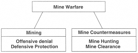
Figure 2-1 The two operational subdivisions of naval mine warfare: mining and mine countermeasures (MCM). Mine laying can deny hostile forces access to a strategic location while also protecting home waters. MCM includes the search for and destruction of emplaced mines.
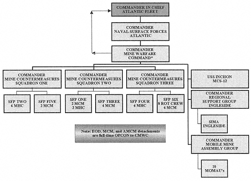
Figure 2-2 Mine Warfare Chain of Command
* Commander, Mine Warfare Command reports directly to the Commander in Chief of the Atlantic Fleet.
AMCM - Airborne Mine Countermeasures
CMWC - Commander, Mine Warfare Command (also referred to as COMINEWARCOM)
EOD - Explosive Ordinance Disposal
MCM - Mine Countermeasures
MCS - Mine Countermeasures Command, Control and Support Ship
MHC - Mine-hunter, Coastal ship
MOMAU - Mobile Mine Assembly Unit
OPCON - Operational Control
SFP - Ships Force Package
SIMA - Shore Intermediate Maintenance Activity
ROT - Rotational
responsible for the Mobile Mine Assembly Group (COMOMAG), which includes all Mobile Mine Assembly Units (MOMAUs) and detachments. This group maintains the U.S. Navy's mine stockpile, and when directed, assembles and completes the final preparation of mines to support mining operations.
The Mine Warfare Command mission statement includes the development and evaluation of mine warfare doctrine, tactics, and equipment. In addition, as technical advisor to the fleet commanders in chief, COMINEWARCOM provides mine warfare planning, intelligence on foreign mine capabilities, and develops countermeasures to protect naval assets.
HISTORY OF MINE WARFARE
The first successful sea mine was invented by David Bushnell in 1776 (he is also credited with the construction of the first submarine in 1775). It consisted of a wooden keg filled with gunpowder and fitted with a primitive contact fuse. Even though the Bushnell mines were not very reliable, they were a successful psychological deterrent to British naval operations in harbors and rivers.
Between the American Revolution and the Civil War, there were continual minor improvements to sea mines, but in general, mines were not a priority for the Navy. In the Civil War, Confederate lieutenant Hunter Davidson invented an electrical mine that could be detonated from shore. The Confederates also invented a mine, the ''Singer'' mine, that detonated on contact. Despite the malfunctions of the Confederate mines, they sank seven Union ships during the war.
The next major mining development was the Hertz horn invented in 1866. This metal horn, variations of which are still in use, contained a solution of a potassium dichromate in a glass tube that broke on impact. Once the solution was released it completed an electrical circuit in the mine battery that fired the mine.
In the Russo-Japanese War (1904–1905), strategic mining by the Japanese eventually led to Russia's defeat. Soon after, sea mines played a major role in World War I, particularly in the Dardanelles-Gallipoli campaign and the North Sea mine barrage. In the Dardanelles Strait, allied forces attempting to reduce Turkish defenses met with mines laid in the strait. Four ships were lost or damaged and plans to take Istanbul were given up. In the North Sea, to limit access to the open Atlantic, the Allies laid 70,117 mines in a 230-mile area in the northern portion of the English Channel. Smaller fields were laid in the southern portion of the channel (Morison, 1995). By the end of World War I, the mine had proven itself to be a highly effective naval weapon that dramatically changed war at sea. But, extensive mine laying during the war necessitated significant advances in MCM. The British invented most of these countermeasures, and some of these techniques are still in use today.
The advent of World War II brought about a new and expanded role for sea mines after a relative period of inactivity between the two world wars. Part of this expanded role was an increase in the use of mines as offensive weapons. In addition, World War II saw the development of mines detonated using acoustic and magnetic influences and the first use of aircraft as minelayers.
During World War II, mines were of critical strategic importance. For example, German mine campaigns in the Baltic Sea effectively sealed the Soviet fleet in port for the entire war. In the Pacific, Allied "Operation Starvation" laid over 11,000 influence mines in Japanese shipping routes to Southeast Asia and also in Japanese harbor entrances (Morison, 1995). This initiative resulted in the damage or destruction of most of the surviving Japanese merchant marine fleet, and it effectively sealed off sea trade to and from Japan. By the end of World War II, sea mines had again proven their effectiveness, and resulted in the sinking of one ship for every 35 mines laid.
Since sea mines provide offensive and defensive capabilities far exceeding their cost, post-World War II naval warfare saw expansions in the use of mines by underdeveloped nations in conflicts with larger superpowers. In the Korean War, offensive mining by communist forces immobilized U.S. Naval operations for more than a week during the landing at Wonsan (Zwolski, 1998). Approximately 3,000 Russian-made contact and magnetic mines caused a fleet of 250 ships to wait off the coast while 10 American minesweepers tried to sweep a clear channel through the minefield (Morison, 1995).
We have lost command of the sea to a nation without a navy, using weapons that were obsolete in World War I and laid by vessels that were used at the time of the birth of Jesus Christ.
—Rear Adm. Smith, Commander, Amphibious Task Force, Wonsan, Korea, 1950.
The most recent example occurred during Operation Desert Storm where mine laying by Iraqi forces in waters off the Kuwaiti coast resulted in extensive damage to three U.S. warships, (USS Tripoli, USS Princeton, and USS Samuel B Roberts; Figure 1-1). Two of the mines that inflicted the damage were World War I vintage.
MINE CLASSIFICATION
Mines are classified according to three characteristics (Box 2–3). The first characteristic is its position in the water column. Bottom mines, which can also include buried mines, are generally found in shallow water, where either surface craft or submarines can easily trigger them. This type of mine is usually influence activated (see below). Moored mines (also called tethered mines) are usually used in deeper water and can be positioned at any depth in the water column. Moored mines are highly effective against both ships and submarines. Tethered mines are primarily used as anti-submarine weapons and can remain passive until the target satisfies its firing criteria. Some tethered mines contain torpedoes or mobile weapons that have the ability to home on targets. Drifting mines move with the prevailing current direction and are designed to float at or just below the sea surface. Drifting mines were banned in 1907 by the Hague Convention, but they are still used by many "rogue" nations. As little as 20 years ago, a minefield could only be emplaced in relatively shallow water (less than 600 ft.). New trends in mine development enable mines to be positioned in deeper water where they will augment anti-submarine and ship barriers and present serious difficulties for minehunting and sweeping.
The second characteristic is its method of delivery (although most mines can be altered for a different mode of delivery). Aircraft-laid mines are generally used for offensive actions where mines need to be rapidly deployed. These mines are dropped like bombs from an aircraft. Most mines in the current U.S. Naval arsenal are aircraft laid mines (Table 2-2). Surface laid mines can be deployed from a variety of ships, enabling them to be laid secretively. The United States no longer maintains a stockpile of surface-delivered mines, although this is a common delivery method for other nations (Table 2-2). Submarine-laid mines are designed to be fired out of torpedo tubes and thus, these types of mines are often torpedo shaped.
The third characteristic is its method of activation. Influence activation is the most common method (Table 2-2). Detectors are used to sense changes in fluid pressure or acoustic, magnetic, and electric fields (or a combination of all four). Sensors can be designed to distinguish between different types of vessels or to have delays before detonating to ensure maximum damage to the triggering vessel (Table 2-2). Contact mines are the oldest technology for mine activation and, in the simplest version, are designed to detonate when "horn" on the mine is bent. Controlled mines are triggered remotely, using cables connected to shore, although new designs can be remotely controlled, which will effectively allow a minefield to be turned on and off when needed to allow ships to pass through the mined area. This type of mine is typically used defensively and is particularly effective in preventing entrance to straits or confined areas.
There are numerous mines in use by U.S. and foreign navies (Table 2-2). These mines range from simple limpet mines that are magnetically or mechanically attached to an object and detonated with a time fuse (Yugoslavian M-71) to the highly sophisticated Swedish BGM 100 mine, which employs an advanced mine shape and sophisticated sensors to prevent detection. Mines are constructed in a wide range of sizes and can operate in water depths of 0–500 m (Table 2-2). These parameters, when considered along with the high oceanographic variability in shallow water environments, determine the ability of MCM forces to detect mines in the coastal zone.
|
BOX 2-3 Mine Characteristics
|
TABLE 2-2 Common Mines in Use by Various Nations
|
Country |
Name |
Type |
Description |
|
Brazil |
MCF-100 |
Moored contact mine |
Can be programmed to remain inert for a fixed period of time, then self-release and anchor itself at the desired depth; can be fitted with an influence sensor. |
|
Denmark |
MTP-19 |
Cable-controlled mine |
Fully remote controlled; can be operated at distances of 12 km or more; consists of a portable weapon control unit, distribution box, and the mine itself. |
|
Germany |
SM G2 |
Ground influence mine |
Has a non-magnetic casing with acoustic, magnetic, and pressure influence sensors; mine will detonate when preset influence parameters are recognized. |
|
|
DM 211 DM 221 |
Anti-frogman underwate signal charge |
Anti-frogman depth charge protects ships and harbor installations against divers; signal charge is used for encoded submarine-to-surface ship communications. |
|
Iraq |
A1 Kaakaa/16 |
Floodable submersible mine |
Possibly the largest mine in the world that is designed to destroy offshore structures; operates even in very deep water; timer or remote-control detonation. |
|
|
Sigeel/400 |
Ground mine |
Seabed mine for deep and shallow water; for use against medium and large targets; can be ship or helicopter deployed. |
|
Italy |
MR-80 |
Seabed influence mine |
Actuated by magnetic, acoustic, and pressure influences from the target; body is composed of epoxy resin and glass fibre. |
|
|
MP-80 |
Seabed influence mine |
Similar influence activation as the MR-80 but with microprocessors to discriminate between target and countermeasures. |
|
|
Murena |
Seabed influence mine |
Similar to MP-80 but with an advanced microprocessor-firing device. |
|
|
Manta Mine |
Shallow seabed influence mine |
A dual influence (magnetic and acoustic) anti-invasion mine shaped to rest firmly on the seabed even in strong flows. |
|
|
Seppia |
Moored influence mine |
Programmable mine that can operate on any type of bottom against all types of targets; can select targets and discriminate against countermeasures; can be remotely controlled. |
|
Russia* |
MDM series (MDM 1–5) |
Seabed influence mines |
Can be laid from a variety of platforms, activated with either acoustic-magnetic or acoustic-magnetic-pressure sensors. |
|
|
SMDM series |
Self-propelled seabed mines |
Similar to MDM mines but are placed in the body of a torpedo to be laid by submarines. |
|
|
PMK-1 |
Underwater rocket-powered torpedo |
A combined mine based on a torpedo with an on-board computer and sensor to identify the target and compute the required trajectory; detonation using combined influence, contact, and time fuse. |
|
|
MSHM |
Continental shelf mine |
Acoustic sensor detects and identifies the target, computes the required trajectory before the underwater rocket is fired to home in on the target. |
|
Spain |
MO-90 |
Moored influence mine |
An intelligent multi-influence mine, parameters can be programmed into the weapon's computer before deployment; incorporates anti-minesweeping countermeasures. |
|
|
Mila-6B |
Naval limpet mine |
Time-fused mine that can be used as a demolition charge; attached to underwater structures mechanically or magnetically. |
|
Length (mm) |
Width (mm) |
Height (mm) |
Weight (kg) |
Charge (kg) |
Operational Depth (m) |
|
1,400 |
1,020 |
1,500 |
770 |
160 |
3–50 |
|
1,000 |
1,090 |
1,128 |
800 |
300 |
3–20 |
|
2,000 |
600 |
600 |
750 |
N/A |
N/A |
|
268 DM211 145 DM221 |
60 |
60 |
1.4 DM211 0.8 DM221 |
0.5 DM211 0.05 DM221 |
6 |
|
3,400 |
3,400 |
3,000 |
16,100 |
9,000 |
N/A |
|
700–980 |
700–980 |
850 |
535 |
400 |
N/A |
|
1,646–2,750 |
533 |
533 |
565–1,035 |
380–865 |
5–300 |
|
2,096 |
533 |
533 |
780 |
630 |
5–300 |
|
2,096 |
533 |
533 |
780 |
630 |
5–300 |
|
980 |
980 |
470 |
225 |
150 or 180 |
2.5–100 |
|
1,560 |
533 |
533 |
870 |
200 |
20–300 |
|
1,530–3,060 |
450–790 |
450–790 |
525–1,500 |
300–1,350 |
15–35 to 15–300 |
|
7,900 SMDM-1 |
533 SMDM-1 |
533 SMDM-1 |
1,980 SMDM-1 |
480 SMDM-1 |
4–100 SMDM-1 |
|
11,000 SMDM-2 |
650 SMDM-2 |
650 SMDM-2 |
5,500 SMDM-2 |
800 SMDM-2 |
8–150 SMDM-2 |
|
7,830 |
533 |
533 |
533 |
1,850 |
350 |
|
4,000 |
533 |
533 |
1,500 |
250 |
60–300 |
|
1,180 |
1,090 |
1,690 |
1,060 |
300 |
5–340 |
|
350 |
350 |
150 |
65 |
N/A |
0–40 |
|
Length (mm) |
Width (mm) |
Height (mm) |
Weight (mm) |
Charge (kg) |
Operational Depth (m) |
|
1,015 |
800 |
385 |
190 |
105 |
5–100 |
|
1,125 |
660 |
1,125 |
450 |
80 |
20–200 |
|
2,000 |
750 |
750 |
800 |
80 |
20–200 |
|
1,700 |
600 |
700 |
700 |
200–400 |
N/A |
|
1,440–2,540 |
533 |
533 |
569 |
350 |
5–200 |
|
2,500 |
533 |
533 |
990 |
600 |
10–200 |
|
2,250–3,000 |
844–1,060 |
844–1,060 |
542–1,010 |
300–576 |
45–350 |
|
2,250–3,830 |
400–630 |
400–630 |
240–926 |
24–204 |
45–91 |
|
115A |
|
|
115A |
|
|
|
450 |
|
|
61 |
|
|
|
2,200–3,800 |
271–533 |
271–533 |
227–908 |
89–202 |
<100 |
|
3,700 |
533 |
533 |
1,075 |
45 |
>305 |
|
4,090 |
485 |
485 |
745 |
N/A |
<100 |
|
670 |
430 |
320 |
50 |
27 |
30 |
|
2,823 |
534.4 |
534.4 |
1,000 |
700 |
50–150 |
|
345 |
345 |
245 |
14 |
3 |
30 |
MINE COUNTERMEASURES
Mines are difficult to detect in the complex nearshore environment, as they are relatively small, easily concealed, and can be laid from nearly any platform. This is particularly true for modem mines that have MCM resistant features, such as anechoic coatings, non-ferrous components, and unconventional shapes. Often, complex and expensive equipment is needed to efficiently and effectively hunt and neutralize mines. As a result, countering mines requires financial expenditure out of proportion to the size and cost of a typical sea mine. This imbalance is increasing as mines become more sophisticated.
MCM can be both passive and active (Box 2–4). Passive MCM relies on limiting the influence of the ship's capability to be sensed by a mine. This is generally accomplished by reducing emitted acoustic and magnetic and electric signals from the vessel.
Active MCM includes both minesweeping and mine-hunting. Influence minesweeping uses acoustic, magnetic, and pressure signals to detonate emplaced mines. Mechanical sweeping uses a towed sled or other type of device to cut the cables of moored mines. These mines then float to the surface and are detonated by other means.
Minehunting is the safest and most effective method of dealing with mines, particularly with modern influence mines. Unlike minesweeping, where techniques need to be altered with variations in mine activation methods, minehunting is less dependent on the technical characteristics of the mine. Minehunting primarily relies on sophisticated high-frequency sonars, high-fidelity sidescan sonars, and magnetometers; either towed, hull-mounted, or hand-held. Once mines are located, they are destroyed using mine neutralization vehicles (Figure 2–3).
Oceanic conditions greatly influence offensive mining and MCM operations. Variations in environmental parameters, such as bathymetry, salinity, temperature, tidal range, currents, water clarity, and seafloor character, can alter and significantly degrade sensor performance and reduce operational capabilities. Many of the parameters listed above are collected in the battlefield by MCM forces. Detailed route surveying by the Naval Oceanographic Office (NAVOCEANO) outside periods of conflict provides data to support in situ battlefield measurements. Route surveys contribute a baseline image of passage routes, thereby reducing operational workloads to identification of changes in a baseline environmental description.
STRUCTURE OF MINE COUNTERMEASURE FORCES
Recently, the U.S. Navy reassessed its MCM strategy of maintaining only special purpose MCM forces and is now developing MCM capabilities that will be an integral part of carrier battle groups and amphibious ready groups (Box 2–6). These forward-deployed MCM capabilities have been defined as "organic" (Box 2–6). This change from an entirely dedicated MCM force to a combination organic and dedicated MCM force has occurred, in part, because of fiscal requirements to combine or develop multi-purpose assets and also because logistically dedicated MCM forces are often not stationed near areas of conflict and thus are unable to reach the battlefield in a timely fashion.
|
BOX 2–4 Mine Countermeasures Passive
Active
|
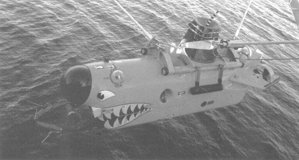
Figure 2–3 The Mine Neutralization Vehicle is used to destroy mines once they are located.
|
BOX 2–5 Goals for Naval Mine Countermeasures (MCM)
|
Source: Rhodes and Holder, 1998
|
BOX 2–6 Dedicated and Organic MCM forces Dedicated-land, air, surface, or sub-surface forces trained and equipped specifically for and focused on MCM operations. Organic-capability that is integral to forward-deployed forces to allow early MCM operations. Source: Rhodes and Holder, 1998 |
Dedicated Mine Countermeasures
Dedicated MCM forces are the traditional special purpose units assembled for mine-hunting duties. Despite the Navy's recent moves to improve organic MCM capabilities, dedicated forces are the backbone of U.S. Naval MCM operations. These forces are highly trained with more advanced capabilities than exist in the organic MCM forces. Dedicated forces are able to reinforce organic MCM forces when the mission demands capabilities beyond those of organic systems.
Dedicated MCM forces rely on the combined assets of surface MCM ships, airborne MCM helicopters, and Navy Explosive Ordinance Disposal (EOD)/Naval Special Warfare (NSW) forces to ensure effective mine detection, classification, sweeping, and neutralization (Table 2–3; Box 2–7).
There are three classes of vessels in the dedicated MCM fleet. The largest of these is the USS Inchon (MCS-12; Table 2–3; Figure 2–4). The Inchon, originally commissioned in 1970, was redesigned in 1996 to provide support for sustained MCM operations by furnishing a landing platform for MH-53E Sea Dragon minesweeping helicopters and also to act as a repair and re-supply facility for Avenger and Osprey class coastal mine-hunters. The Avenger (MCM-1) class was designed to find, classify, and destroy moored and bottom mines in both coastal and offshore areas (Table 2–3; Figure 2–5). The ships use a fiberglass-sheathed wooden construction to make the hull less detectable by influence mines. Avenger class sweepers employ sonar and video systems for minehunting and use remotely controlled mine detonating devices, cable cutters, and other more conventional minesweeping measures for mine removal. The smaller Osprey class (MHC) has a shorter endurance and thus depends on support ships or shore-
TABLE 2–3 Primary Vessels of the Dedicated Mine Countermeasures Fleet
|
BOX 2–7 Dedicated Mine Countermeasures (MCM) Mission Provide the most maneuver area for joint and naval assets in the least amount of time with the least amount of residual threat to transitors while incurring minimal risk to MCM platforms. |
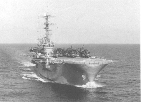
Figure 2–4 The USS Inchon provides support for sustained mine countermeasure (MCM) operations by furnishing a landing platform for MH-53E Sea Dragon minesweeping helicopters while also acting as a repair and re-supply facility for Avenger and Osprey class coastal mine-hunters.
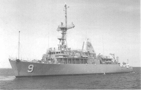
Figure 2–5 The Avenger class of minesweeper was designed to find, classify, and destroy moored and bottom mines in both coastal and offshore areas. This class has added capabilities to conduct mechanical, acoustic, and magnetic mine sweeping. The ships have a fiberglass-sheathed wooden construction to make the hull less detectable by influence mines.
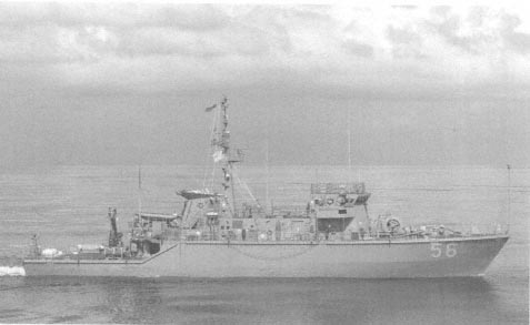
Figure 2–6 The Osprey class has a shorter endurance than the Avenger and is more operationally capable due to its lower acoustic and magnetic signature. The Osprey only has a minehunting capability. Osprey class ships are constructed from glass-reinforced plastic (GRP) fiberglass.
based facilities for re-supply (Table 2–3; Figure 2–6). The small size of the Osprey MHC ships limits them to operations in shallow coastal waters and harbors. Osprey class ships are constructed from glass-reinforced plastic (GRP) fiberglass and have minehunting capabilities similar to the Avenger MCM ships. Unlike the MCM-1 class, the MHC is not equipped with minesweeping gear and is solely reliant on its minehunting capabilities.
In addition to the above vessels, there are other systems that are essential to the dedicated MCM force (Box 2–8). Dedicated airborne MCM (AMCM) forces rely on the MH-53E Sea Dragon class of helicopters (Figure 2–7)
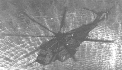
Figure 2–7 The MH-53E Sea Dragon class of helicopters have minehunting and sweeping capabilities using a variety of towed gear.
|
BOX 2–8 Other Dedicated Mine Countermeasure (MCM) Assets Airborne MCM (AMCM): MH-53E
Underwater MCM (UMCM): Explosive Ordinance Disposal (EOD)
Underwater MCM (UMCM): Marine Mammal System (MMS)
Source: Mine Warfare Command, 1999 |
whose minehunting and sweeping capabilities depend on towing a variety of gear, such as minehunting systems and minesweeping (mechanical/influence) equipment. Sea Dragon helicopters have a four-hour mission capability.
Underwater mine countermeasures (UMCM) depend on both the EOD units and specially trained Marine Mammal System (MMS) mammals, which perform tasks similar to those of the EOD units with high confidence and greater speed. The MMS force is the only asset in the fleet that can detect buried mines. EOD and MMS systems can together accomplish a range of tasks from mine search through identification. In the future EOD and MMS teams will be replaced by Unmanned Undersea Vehicles (UUV), which are not limited by endurance, particularly in cold or otherwise hostile environments. UUVs also have the advantage of removing the warfighter from the battlefield.
Organic Mine Countermeasures
An important component of a successful MCM program is the capability of carrier battle groups, amphibious ready groups, and other naval assets to deal with naval mines while dedicated MCM forces are in transit or otherwise occupied. Without this capability, forward-deployed forces must remain idle while waiting for mine-clearing assistance. To ensure that commanders of forward-deployed assets are able to operate freely in the nearshore battlefield, the Navy has developed organic MCM strategies (Box 2–9). The goal of organic MCM is to enable Naval forces to assess the danger posed by a potential minefield, reduce this risk to an acceptable level, and concentrate on their primary mission. By 2005, the first aircraft carrier battle group will no longer rely solely on dedicated minesweep-
|
BOX 2–9 Organic Mine Countermeasure (MCM) Strategies Detect presence or absence of mines. Perform basic exploratory and reconnaissance operations
Operational maneuver options
Organic limitations include:
|
ers. Instead, each battle group and amphibious ready group will have air, sea, and undersea capabilities to hunt and destroy mines.
In the future, naval organic MCM capabilities include not only on and off-board sensors but also the operational infrastructure necessary to plan MCM operations and implement tactical decisions to reduce the risk of operating in mined waters. Tools used by organic MCM forces include H-60 helicopter-equipped AMCM systems, surface-ship-deployed mine reconnaissance capabilities, and submarine-deployed systems. There is no single piece of equipment that can provide all operational capabilities needed; thus organic MCM forces are using and developing three underwater reconnaissance systems, two airborne mine detection systems, and two airborne mine destruction systems. Each of these systems will have the capability of dealing with a small number of mines; operated together these systems will be able to cope with the operational challenges posed by the full range of naval mines.
A significant organic MCM development is the ship-deployed Remote Minehunting System (RMS) that was developed to provide battle groups and surface combatants with a means of detecting and avoiding mines from deep to very shallow water. This remotely operated system will use computer-aided detection and precise navigation systems for mine location and classification. Other organic MCM systems in development include the Airborne Mine Neutralization System (AMNS), which is a remotely operated, expendable, torpedo-like device capable of identifying and neutralizing bottom and close-tethered mines; the Airborne Laser Mine Detection System (ALMDS), an electro-optical mine detection system that uses an aircraft-mounted laser to detect floating and near-surface mines; and the Rapid Airborne Mine Clearance System (RAMICS), which provides near-surface mine neutralization using a gatling gun system.
Battlefield reconnaissance data are essential for safe nearshore operations. Thus, plans are in place to develop and expand organic MCM capabilities with both Near-term and Long-term Mine Reconnaissance Systems (NMRS and LMRS). The NMRS will be operational first and will provide limited mine detection, classification, and localization from a UUV launched and recovered from the torpedo tube of a Los Angeles class submarine.
MINE WARFARE DOCTORINE
Naval Warfare Publication 3–15
Naval Warfare Publication (Department of the Navy, NWP 3–15.41) ''Mine Countermeasures (MCM) Planning and Procedures'' provides operational planning and calculation procedures for use in the formulation and evaluation
of MCM operations. Under current procedures, environmental data, along with available intelligence data, are merged with system performance data to plan an MCM mission.
The full spectrum of environmental parameters affecting sensor and system performance are not consistently monitored during MCM operations. Of the environmental data collected, only those describing seafloor properties are considered within NWP 3–15 as these parameters strongly impact the level of backscattered acoustic energy and thus, significantly affect sonar performance. To support minehunting sonars, bottom composition, bottom roughness, percent impact burial, and NOMBO densities are extracted or estimated from available meteorological and oceanographic data holdings. In accordance with NWP 3–15, sediment grain size is limited to three groupings: mud, sand, or rock, and bottom roughness is characterized as smooth, moderate, or rough. With the high-sonic frequencies used by minehunting sonars, bottom features (i.e., ridges, sand waves, etc.) in excess of 0.5 m are defined as rough. NOMBO density is the estimate of mine-like bottom objects occurring in a square nautical mile (nm2). NOMBO densities of 0–14 /nm2 are categorized as clutter density 1; densities from 15 to 40 NOMBOS/nm2 are categorized as clutter density 2; and densities in excess of 40 NOMBOS/nm2 are classified as clutter density 3. NOMBO density influences the amount of incorrectly identified mines and the time needed to complete a mission. In remote regions, bottom roughness and NOMBO density are often difficult to assess, as the definition of these parameters requires high-resolution bathymetric and sidescan sonar surveys, which are not always available.
Once bottom composition, estimation of mine burial, bottom roughness, and NOMBO density data are acquired, they are combined to form a mine warfare bottom category in accordance with NWP 3–15. Bottom categories range from a best case "A" defined as an optimum minehunting seafloor, to the worst case "D" typified by a potential for high-mine burial. When combined with NOMBO density estimates, the seafloor can be categorized
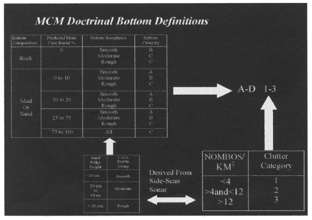
Figure 2–8 Bottom definitions used for mine warfare decision making as defined by mine countermeasure doctrine.
from "A1" to "D3." This estimate is used to obtain a value for the sonar detection width "A" and probability of mine detection "B'' referenced from NWP 3–15. After "A'' and "B" values are determined, the MCM operator decides the number of ship tracks (on lanes) and track spacing necessary to achieve an acceptable safe clearance level (Figure 2–8).
Shortfalls in NWP 3–15
Although it is well known that the environment plays a pivotal role in MCM operations, current doctrine (NWP 3–15) does not adequately account for the highly variable conditions often encountered in MCM operational areas. NAVOCEANO maintains high-resolution geologic, bathymetric, and oceanographic databases in support of fleet mine warfare efforts, yet the full range and resolution of these data are not typically exploited. For example, sonar width "A" is highly dependent on potentially variable seawater physical properties. Despite this, sonar width is a fixed quantity in NWP 3–15 for all environments. Consequently, environmental variations can result in data voids, termed "holidays," because the assumed sonar detection width "A" is greater than the actual sonar detection width. Conversely, redundant coverage (wasted time) will result when the assumed width "A" is less than the sonar detection width for the environment in question.
FUTURE TRENDS IN MINE WARFARE
To ensure that naval forces are able to maneuver and control operations in the nearshore environment, there should be continued development of mine laying and mine countermeasures, while also incorporating advancements in environmental predictive capabilities to maximize the effectiveness of mine warfare operations. This can occur only with increased integration of mine warfare into fleet training, exercises, and deployments. Despite the strategic benefits of mine warfare, mine warfare has undergone periods of relative neglect between conflicts. Currently, budget increases are enabling the Navy to overhaul its mine and MCM operations. Future funding increases are also a possibility, as the President has requested $64 million for research and development of MCM (Abel, 1999).
The numerous planned initiatives to refine the capabilities of mine warfare (MIW) forces involve improved hardware and support for the MIW community. With respect to hardware, one future direction is the refurbishment of outdated mines to extend their operational life, using upgrade kits that modernize the firing mechanism while retaining the original mine case and warhead.
Numerous new technologies are also emerging that will improve the effective range, countermeasure resistance, reliability, and versatility of naval mines. A significant advancement is the propelled warhead (PW) mine that uses buoyancy or propulsion systems to transport a warhead to its target. PW mines have many benefits over more conventional explode-in-place (EIP) mines (see "Mine Classification" section, earlier in this chapter): greater range, increased speed to target (reduces the time available for the target to initiate countermeasures or evasive maneuvers), reduced need for a large number of mines, improved target detection, and deep water operational capabilities where mechanical minesweeping is difficult.
New countermeasure-resistant mine designs include fiberglass and non-ferrous cases that reduce maintenance and detection. These cases can also have anechoic coatings to reduce their sonic signature. New mines are also being designed with unconventional shapes, making them difficult to identify on seafloor images. Mines are being fitted with high-sensitivity multiple-influence detonation systems with delayed sensors to fire a preset time after a triggering signal. A significant advance is the self-burying mine. This mine will dramatically reduce the effectiveness of current minehunting sonars and cause an increased dependence on slower minesweeping techniques. Future advancements in remote control (RECO) systems will enable mines to be turned on and off when needed and enable them to be detonated remotely. RECO-equipped mines will provide an important tactical advantage, particularly in shallow water and in shipping channels, where it may be necessary to deactivate the mines to allow certain ships to pass.
Advances in minehunting and sweeping are also underway. UUVs will increase the capability to search an area for mines without compromising intent and position. These vehicles will incorporate a variety of sensors to survey
nearshore operational areas clandestinely and, if necessary, neutralize emplaced mines. This advance will remove personnel from the dangerous job of minehunting and destruction. However, to increase the effectiveness of UUVs, greater speed and range and deeper diving capability is needed (Morison, 1995). In water depths greater than 10 ft., the diesel-powered RMS discussed previously will eventually provide the dual capacity to locate and neutralize mines. The next RMS prototype will have an over-the-horizon communications link that will give operational commanders the ability to remotely control the RMS at a range of up to 100 miles. Systems to be used with the multipurpose H-60 helicopters are also under development. These advances in minehunting and sweeping capabilities will greatly reduce the time needed to classify and neutralize mines in the coastal zone.
New systems are also being developed for use in the surf zone. The Shallow Water Assault Breaching System (SWABS) and Distributed Explosive Technology (DET) can deliver an array of explosives to remove mines and obstacles ahead of a landing force. These systems have the advantage of an increased standoff distance, reducing the danger to platforms and personnel.
Advances are also being made in the area of sensor development. For example, the Tactical Acoustics Measurement and Decision Aid (TAMDA) will not only give temperature and depth measurements, as with conventional XBTs, but will also collect salinity and ambient noise data for use in acoustic sensor calibration. TAMDA will also incorporate a broadband probe pulse to determine reverberation and bottom composition, will have a global positioning system (GPS), and will have a longer operational life to provide extended data collection capabilities.
In addition to hardware improvements, improvements to support systems for the MIW community are also planned. Many of these systems will increasingly rely on computer models and advanced oceanographic databases to store MCM-specific types of digital information. An important development will be a shared database containing oceanographic data from all available sources. These data will be used to update and refine environmental assessments and will be the basis of a distributed database digitally available to the end user. Furthermore, recent developments in advanced visualization hardware and software systems will enable the mine warfighter to interact, in real time, with 3D graphical representations of oceanographic data. This capability will enhance the warfighter's ability to understand local environmental variability and thus will greatly benefit mine warfare operations.
The MIW community will also benefit from advances in data processing algorithms. For example, continued development of mathematical inversion techniques for use on sonic datasets will provide qualitative estimates of bottom type and composition from sonar data. In addition, advances in data processing from sensors, such as LIDAR, will provide high-resolution seafloor bathymetry data and enhance the ability to identify mine-like features in seafloor images.


