
3—
Oceanography and Mine Warfare
Numerous meteorological and oceanographic parameters are important for mine warfare operations (Box 3-1). At present, some of these are part of routine data collection for the Naval Oceanographic Office (NAVOCEANO) and mine countermeasure (MCM) forces (Boxes 3-2 and 3-3). The importance of each of these oceanographic parameters for mine warfare operations vary, in some cases significantly, between different water depths (Table 3-1). For example, in many coastal environments, wind-generated currents are of little importance in the surf zone as they are generally overwhelmed by wave-induced currents, whereas in very shallow water (VSW) and shallow water (SW) zones information on wind-generated currents is essential.
OCEANOGRAPHY OF THE NEARSHORE ENVIRONMENT: THE CHALLENGE FOR MINE WARFARE
A significant challenge for mine warfare operations in the nearshore environment is the shortened spatial and temporal scales of oceanic and atmospheric variability. This complexity makes it difficult to predict environmental changes and their resultant effect on sensors, platforms and weapons (Rhodes and Holder, 1998). Oceanic variability in the coastal zone can result from ocean fronts, freshwater inputs (precipitation and river runoff), local and
|
Box 3-1 Important Environmental Characteristics That Influence Mine Warfare Operations
|
||||||||||||||||||||||
|
Box 3-2 Commander, Mine Warfare Command (COMINEWARCOM)-Acquired Environmental Data
|
|
Box 3-3 The Naval Oceanographic Office (NAVOCEANO)-Acquired Environmental Data
|
TABLE 3-1 The Most Common Oceanographic Datasets Used for Nearshore Mine Warfare Operations and Their Importance in the Different Water Depth Zones Defined by the Navy
|
|
Surf Zone |
VSW |
SW |
Deep Water |
|
SEAFLOOR |
|
|
|
|
|
Bathymetry |
H |
H |
H |
M |
|
Sediment grain size |
M |
H |
H |
M |
|
Seafloor clutter density |
M |
H |
H |
L |
|
Bottom roughness |
M |
H |
H |
L |
|
Mine burial |
H |
H |
H |
L |
|
WATER COLUMN |
|
|
|
|
|
Currents |
L/H* |
|
|
|
|
Water clarity |
L |
H |
H |
M |
|
Temperature and salinity |
L |
M |
H |
M |
|
Waves |
H |
H |
M |
L |
|
Acoustic properties |
N/A |
H |
H |
H |
|
* Within the surf zone, information on wind-generated currents is of low priority as these currents are generally overwhelmed by wavegenerated currents. VSW = Very Shallow Water SW = Shallow Water H = High, a parameter that is essential for mine warfare operations in this depth zone; M = Medium, a parameter that is useful for mine warfare operations in this depth zone; L = Low, a parameter that is of little use for mine warfare operations in this depth zone; N/A = A parameter that is not applicable or not measurable in this depth zone. |
||||
synoptic weather disturbances, tidal fluctuations, sea and land ice, and internal and coastal trapped waves. In the open ocean, fronts vary on time scales of days to weeks, whereas in the coastal ocean they can vary hourly as a result of tidal forcing and local weather phenomena (Martin, 1997). These high-frequency variations have significant impacts on many aspects of mine warfare (MIW) operations, the most important being sensor performance, mine burial capability, and the mobility of MCM forces in shallow water.
Oceanic complexity increases in the surf zone due to the dynamic interaction of the water column with the seafloor and the adjacent landmass. This interaction modifies waves, localizes alongshore currents, influences underwater structures, and forces resuspension of sediments. These factors make data collection and remote-sensing in the surf zone environment extremely difficult.
To ensure continued U.S. Naval domination in littoral mine warfare, it is critical that naval operators have access to tactical decisions aids (TDA) based on sophisticated environmental datasets and results from quantitative models of nearshore oceanographic processes. Numerical models traditionally used in the open ocean are of little use in the coastal zone because of the high-frequency variability in this environment. Current shallow water and surf zone modeling capabilities are not well developed. To advance these models, it is imperative that progress be made in understanding coastal environmental processes.
The ability to process, interpret, and use environmental data for mine warfare operations is critically dependent on high-quality advanced training for mine warfare forces. This need will continue to increase with greater dependence on complex environmental datasets and predictive models. It is thus imperative that concurrent advances occur in warfighter technical training and environmental data collection.
THE ROLE OF OCEANOGRAPHY IN MISSION PLANNING, BATTLEFIELD PREPARATION, AND MISSION SUCCESS
The ocean environment significantly influences mine warfare tactical planning. An in-depth understanding of nearshore environmental variability is important, not only for physical mine placement but also for its impact on minehunting sensors. Despite the complexity of the coastal environment, Naval Meteorological and Oceanographic (METOC) infrastructure is adapting to the challenge of operations in these water depths. Specific goals being addressed are (1) remedying the lack of high-resolution nearshore oceanographic and bathymetric data, particularly in areas of potential conflicts and (2) developing better in situ sampling systems for measurement of tactically significant oceanographic and meteorological parameters.
As discussed previously, the need to improve environmental databases and interactive data visualization capabilities is particularly important for mine warfare planning and operations. The massive databases collected in open ocean environments during the Cold War are an important start, but dedicated nearshore survey data are an essential supplement to existing data. The Director, Expeditionary Warfare (OPNAV N85) and Mine Warfare Command (COMINEWARCOM) are providing resources for developing these databases at a sufficient resolution for MCM applications. This work will require extensive high-resolution, peacetime oceanographic surveys to be completed in high-priority areas (Martin, 1997). Tactical decision aids (discussed below) developed from nearshore oceanographic databases, when modified by in situ data, will provide a powerful tool for the mine warfighter to optimize operational capabilities.
Mission Planning
In current mine warfare mission planning, historical oceanographic data are acquired from the NAVOCEANO database. These data, including seafloor characteristics, water column properties, and atmospheric parameters, are input into the Mine Warfare Environmental Decision Aid Library (MEDAL) to determine optimal lane spacings and predict operational time lines and risk. Once into the exercise, in situ data are collected and input into MEDAL and other TDAs. When in situ data are entered into MEDAL, the operator can output predictions of best and worst-case scenarios for line spacings to balance operational objectives with clearance time and risk. It is important at this stage of operations that mine warfare personnel be receptive to modifying tactics to fit changes in environmental conditions.
In the future, there will be increasing reliance on battlefield sensors for MCM operations. The effectiveness of these sensors is highly dependent on environmental conditions. Understanding the environment in which the sensor is operating and the effects of environmental variability on measurement parameters ensures maximum sensor performance and utility of the resulting data. Because of this requirement, OPNAV N85 is installing the Battlespace Profiler (BSP), a tool similar to a Conductivity, Temperature, Depth (CTD) profiler on all MCM vessels to enable them to measure temperature, salinity, and depth. In part, this requirement will increasingly be met by modern sensors, which maximize system performance by adjusting to environmental conditions.
Advances in sensor and communications technology have provided an important support tool for the warfighter, enabling rapid environmental assessments and vastly improving how naval forces collect and distribute battlefield information. Advances in electronic processing speed and miniaturization have enabled the development of new sensors for Unmanned Undersea Vehicles (UUVs), while innovative image processing of electromagnetic and sonar data is enabling enhanced visualization of the battlefield. In addition, recent advances in both observational sampling systems and numerical modeling techniques make the large amounts of environmental data being collected more accessible to the MCM community. An improved understanding of the circulation, seawater properties, and bottom characteristics of nearshore areas depends upon the success with which these observed and simulated data sets are managed and integrated with visualization and analysis technologies.
SUPPORT FOR MINE WARFARE: INFORMATION AND SYSTEMS
Navy METOC is moving to meet the challenge of nearshore operations by investing resources in new technologies and techniques for characterization of oceanographic variability in the coastal zone. An in-depth understanding of the coastal zone environment will help ensure that naval forces are able to operate freely in these areas.
As part of the Mine Warfare Campaign Plan, COMINEWARCOM and NAVOCEANO have coordinated their efforts to provide an enhanced capability for environmental analysis. As an example, a Route Survey Environmental Data Base Concept of Operations (CONOPS) has been developed to outline how this will be accomplished and how it will provide enhanced environmental capabilities to warfighters at COMINEWARCOM.
Data types presently used include high-resolution sidescan sonar acoustic images collected with Airborne Mine Countermeasures (AMCM) assets; Explosive Ordinance Disposal (EOD) diver reports; and salinity, temperature, and sonic velocity data collected by the BSP. After collection, these data are forwarded to NAVOCEANO, where they are processed and entered into the master data warehouse. NAVOCEANO analysts combine the field-collected data with historical data to develop a description of the environment in question. This analysis is then returned to COMINEWARCOM as a digital file that can be entered into MEDAL, the Comprehensive Environmental Assessment System (CEAS), the Naval Interactive Data Analysis System (NIDAS), and the Unified Sonar Image Processing System (UNISIPS). Data can also be returned to COMINEWARCOM as information contained in other NAVOCEANO products, such as Special Tactical Oceanographic Information Charts (STOICs), acoustic imagery mosaics, and Mine Warfare Pilots (MWP; see below). The aim of these systems and products is to help the warfighter determine the best way to employ sensors and weapons. Figure 3-1 summarizes the environmental data flow between COMINEWARCOM and NAVOCEANO.
Environmental Support Systems
Oceanographic Support Subsystem Data Warehouse
The Oceanographic Support Subsystem Data Warehouse (OSS DW) is both a tool for data location and a facility for management of data, information and software held at NAVOCEANO. A catalog function enables users to locate common software applications for execution or software release. The OSS DW is maintained through a graphical user interface that allows users to query geo-referenced information for a particular area of interest, using Structured Query Language (SQL), the graphical user interface, or a Web browser.
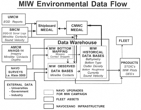
Figure 3-1 Mine warfare environmental data flow between Naval Oceanographic Office (NAVOCEANO) and Commander, Mine Warfare Command (COMINEWARCOM).
Mine Warfare Environmental Decision Aid Library
MEDAL uses historical and in situ environmental data for mine warfare mission planning, system performance evaluation, tactics development, and exercise evaluation. MEDAL integrates command and control capabilities, performance assessment models, algorithms, and environmental databases to determine mine threats, develop hunting and sweeping plans, determine an optimum force mix, and recommend tactics and techniques. In addition to planning, MEDAL is also capable of monitoring operations in progress, assembling in situ measurements for transfer to NAVOCEANO, and executing post-exercise reconstruction and analysis. MEDAL provides the MCM commander with the ability to manipulate the following datasets:
Bathymetry - Bathymetry is stored in MEDAL as individual points from EOD diver observations, the AQS-14 altimeter, soundings, and gridded bathymetric files.
Bottom Characteristics - At present, MEDAL uses 16 categories to describe sediment characteristics and there are plans to increase this to 72 in future builds (Figure 3-2). This information is acquired from historical databases resident at NAVOCEANO and can be augmented by in situ measurements from diver reports or indirectly from video on the AN/SLQ-48 Mine Neutralization Vehicle. Despite the fact that NWP 3–15 limits grainsize to three groupings, sediment grainsize is usually input into MEDAL using the four sediment types in acoustic performance models.
Currents - Surface and seafloor current speed and direction estimated from diver reports are an important component of operational planning. These data are entered into MEDAL as point, processed, or textual information. At present, there are no circulation models incorporated into MEDAL.
Seawater Physical Properties - Seawater temperature and salinity can be obtained from diver reports or CTDs deployed from MCM platforms. Seawater physical properties are mainly used for minehunting sonar performance
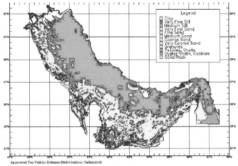
Figure 3-2 A typical example output of seafloor bottom types from the Arabian Gulf. Although it is difficult to distinguish between sediment grainsize shadings in the legend on the right, this figure shows the level of detail available for certain field areas.
models. In the future, MEDAL will also use these data to estimate the performance of other acoustic equipment, including the coverage of acoustic minesweeping gear.
Atmospheric Data - Wind speed and direction and ambient air temperature are the main atmospheric datasets collected. Wind speed is an important input to sonar performance algorithms used by AMCM operations and also for helicopter flight parameters, such as blade and pylon unfolding, rotor engagement, and launch. Wind speed is also a factor in sea state, and affects both Surface Mine Countermeasure (SMCM) and Undersea Mine Countermeasure (UMCM) operations. Future versions of MEDAL will be able to incorporate regional climatic databases.
Magnetic Capability - These data include measurements of seawater and sediment conductivity, electrical depth, and reflection coefficients used to calculate the performance of minesweeping systems.
Acoustic Data - Acoustic data entered into MEDAL are the K1 and K2 parameters (slope of a transmission loss curve up to and beyond 100 yards) used to estimate coverage for acoustic minesweeping equipment. At present, no algorithms exist to recalculate these parameters according to environmental changes, but future algorithms may take into account acoustic water depth, seawater physical properties, wind speed, and bottom composition.
Comprehensive Environmental Assessment System
CEAS provides multi-disciplinary environmental data assessment and analysis, survey and special deployments planning, and MIW support. CEAS was designed to provide a broad range of capabilities while also having the flexibility for future enhancements. Some of these capabilities are the production of acoustic image mosaics, data queries, the creation of derived data, and output of diverse digital and hardcopy export formats.
At present MEDAL is limited in its ability to input, manipulate, and display oceanographic data. Thus, the graphic capabilities of CEAS are being used at COMINEWARCOM and at sea on the USS Inchon as a briefing tool to subset data from large regional datasets and to view and manipulate sidescan sonar imagery.
Naval Interactive Data Analysis System
NIDAS is a Windows-based application that processes and analyzes temperature and salinity data from vertical profiles (historical or real time), gridded profiles (ocean models), or satellite sea surface imagery. NIDAS is designed to be used with shallow water, high-variability datasets typical of the coastal zone where statistics and modeling may be of little use. Specific uses for NIDAS include the development of survey sampling strategies, quality control of ocean profile data, construction of ocean climatological databases, oceanographic product generation (see below), and quality control of ocean thermal models. NIDAS supplements MEDAL, enabling the COMINEWARCOM METOC officer to construct synthetic profiles; perform three-dimensional grid slicing as waterfall plots or horizontal and vertical contours; export observed, provinced, or gridded profiles for use in sonar performance models; and input in situ CTD and Expendable Bathythermograph (XBT) data for comparison to historical master oceanographic observation datasets (MOODS) or gridded provinced databases.
Unified Sonar Image Processing System
UNISIPS was designed to standardize the processing of acoustic imagery data. UNISIPS can perform signal and image processing of raw data to create digital mosaics. UNISIPS can also use acoustic data to determine seafloor characteristics (e.g., clutter density and roughness), which are then entered into the bottom characteristics database. UNISIPS is being used as a real-time bottom-mapping analysis tool during exercises. This provides the METOC officer with extended capabilities, such as comparison of collected imagery to historical imagery to locate mine-like contacts.
Environmental Data Products
Acoustic Imagery Mosaics
Acoustic imagery mosaics are constructed in UNISIPS, and can be produced in either hardcopy or digital formats (Figure 3-3). Mosaics can then be input into CEAS, where additional environmental or operational information can be added. If a historical database of images is available, mosaics are an extremely useful tool for indicating changes in seafloor clutter which could indicate the presence of emplaced mines (Figure 3–4). Since CEAS is a geographic information system (GIS) application, layers of information can be compiled allowing the MCM commander to use the environment for tactical advantage. Acoustic imagery mosaics provide accurate estimates of bottom roughness and clutter density (Figure 3–5), and are source data for determining MIW doctrinal seafloor classifications. More important, imagery mosaics allow the MCM commander to refine operational areas based on observed topography. Since the ultimate goal is to reduce time lines and risk, operational areas and routes can be directed over more benign geologic areas where time lines and risk are lower.
Special Tactical Oceanographic Information Charts
STOICS are 1:25,000-scale bathymetric plots of a particular area of interest that are accompanied by environmental data collected over a specific time frame (e.g., month or season). This product has been designed to be a simple chart with the exact data needed by the user for nearshore mission planning. STOICS are not only used by the mine warfare community but also the special warfare and amphibious warfare communities.
Mine Warfare Pilots
MWPs provide environmental information essential for minefield and MCM planning and complement mine warfare doctrine. Specifically, MWPs include information on human activities, climatology, tides, currents, waves, sea ice, physical properties of seawater, seabed characteristics, and acoustic, magnetic, and biologic characteristics of a region of interest. As with STOICS and OESs (described below), MWPs are an essential planning tool for the COMINEWARCOM METOC officer. MWPs are used to define the MCM operational environment, including po-
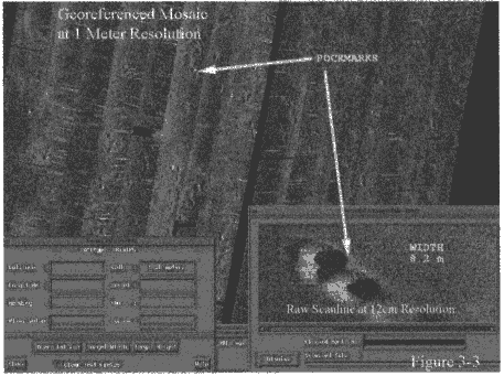
Figure 3-3 An acoustic imagery mosaic with one meter resolution. On this image numerous "pockmarks" can be seen. These features are likely to have resulted from seafloor release of hydrocarbon gases.
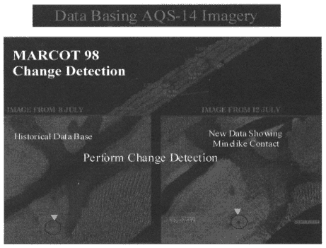
Figure 3–4 A pair of acoustic imagery mosaics collected four days apart. Comparison of the older image on the left and the newer image on the right shows the appearance of a mine-like contact in the time between the collection of the two images.
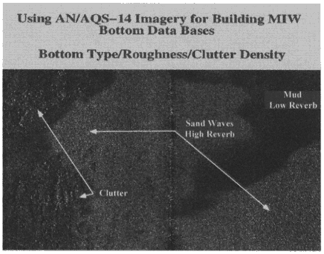
Figure 3–5 Acoustic imagery mosaics can be used to determine bottom type, roughness, and clutter density. In this image, an area of low reverberation, which has been interpreted as muddy sediment, can be seen in the upper right and high reverberation in the center of the image has been interpreted to reflect sandy sediment. An area of high clutter can be seen on the left.
tential limitations on equipment and platforms, and to supplement information and analyses generated by MEDAL, CEAS, NIOAS, and UNISIPS. MWPs are digitally output to the METOC officer.
Oceanographic/Environmental Summary
OESs provide baseline oceanographic information on specific geographic areas. These summaries can include physical oceanographic (currents, waves, tides, etc.), bathymetric, geomorphologic, biologic, and acoustic data. Many of the data types included on OES plots are similar to those on MWPs, but the latter generally cover a broader geographic region. As with MWPs, OESs are produced in digital format.
Tailored Requests for Planning and Exercises
NAVOCEANO also receives requests for a wide range of specific datasets to support MIW exercises. This tailored information provides an environmental description of the operational area as support for planning and briefings.
SUPPORT FOR MINE WARFARE: ENVIRONMENTAL SCIENCE PROGRAMS IN THE OFFICE OF NAVAL RESEARCH
The role of the Office of Naval Research (ONR) is to coordinate, execute, and promote science and technology programs in the U.S. Navy and Marine Corps through universities, government laboratories, and other research
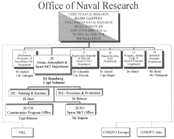
Figure 3–6 Organizational chart of the Office of Naval Research (ONR).
organizations. In addition, ONR provides technical advice to the operational branches of the Navy through the Chief of Naval Operations and the Secretary of the Navy (ONR, 1999).
The science and technology arm of ONR maintains close links with the oceanographic research and technical development communities by supporting proposals that will benefit naval operations (ONR, 1999). A major ONR goal is to encourage the transition of basic and applied research from the laboratory to the fleet. To facilitate this transition, ONR divisions use federal funding categories: 6.1 (basic and applied research), 6.2 (exploratory development), and 6.3 (advanced development). ONR also uses a series of program codes to identify areas of research focus (Figure 3–6). Most oceanographic research is funded in the Ocean, Atmosphere, and Space Science Technology Department (ONR 32) that also oversees the mine warfare science and technology program (Box 3–4). This program focuses on research that will improve the detection, identification, and neutralization of mines in open ocean and littoral environments while also improving offensive mining capabilities (ONR, 1999). Details of ONR research and technology development programs of special interest to mine warfare can be found in Appendix E.
|
BOX 3–4 ONR Department of Ocean, Atmosphere, and Space Science Technology Research Interests Relevant to Mine Warfare
|


