
3
Volcano Monitoring
WHAT IS VOLCANO MONITORING AND WHY SHOULD THE VHP DO IT?
Whereas volcano research seeks to explain all types of behavior of all volcanoes based on first principles and assessment aims to determine the long-range activity of a single volcano based on its past, monitoring looks at the short-term changes of a currently or recently active volcano in order to predict if and when a volcanic crisis might develop. To be effective, monitoring must be done before, during, and after eruptions and must be integrated with carefully designed communication schemes. It requires the type of long-term commitment of time and resources that academic and industry scientists generally cannot make. Furthermore, the quality of monitoring depends on the amount of experience of the participating scientists. For these reasons, the VHP is uniquely qualified within the United States to carry out volcano monitoring.
Monitoring strategies vary greatly depending on a number of factors such as the activity of the individual volcano, access, and available personnel and funding. Some volcanoes are monitored by a single seismometer, whereas others are covered by a comprehensive array of instruments. Certain monitoring methods, such as securing gas samples from fumaroles, require that scientists enter active vent areas. Other data can be collected remotely and with less risk, such as telemetered seismic and geodetic measurements or satellite-derived images or spectra. Volcano monitoring techniques can be simple (i.e., taking the pH of a thermal spring every several weeks) or complex (e.g., broadband source studies and seismic tomography).
Rapid advances in technology allow for more precise monitoring today than was imaginable when the VHP was formed. Monitoring of Kilauea was once carried out using manually-read water-tube tiltmeters and smoke drum seismic recorders, instruments that seem quaintly archaic today. At Mount St. Helens, deformation monitoring was conducted with electronic distance-measuring devices that determined
changes in length with a precision of 20 mm over a 10-km-long baseline. Such measurements could be manpower intensive, but the data were relatively easy to reduce. Today, these measurements would likely be made with continuously recording global positioning system (GPS) receivers, supplemented by interferometric synthetic aperture radar (InSAR). GPS provides three-dimensional positioning with a precision of about 3 mm. InSAR can generate maps showing changes in vertical and horizontal position with a precision approaching 10 mm. Neither method requires personnel in the field (after initial installation); however subsequent data analysis can be highly complex. Similar changes are taking place in other subdisciplines, such as seismology and satellite-based remote sensing.
Done effectively, monitoring not only provides timely warnings to civil authorities of escalating hazards, but also leads to improved understanding and models of how volcanoes work. Monitoring generates baseline information against which changes in volcano behavior can be compared. These data are the essential ingredients with which scientific ideas and interpretations advance. Preserving the integrity and accessibility of data archives is thus essential if future volcanologists are to benefit from the decades-long records of volcano behavior gathered by the VHP.
A fundamental question facing the VHP is how to establish a balance between maintaining traditional methods that may be comparatively simple and inexpensive, and introducing new, more informative techniques that are more complex and costly. Archiving approaches have to be downward compatible, so that both old and new information may be accessed and compared in longitudinal or retrospective studies. Similarly, staffing decisions must ensure that sufficient knowledge is maintained about older data sets, even as younger scientists and technicians with new skills are recruited.
WHAT IS THE STATUS OF MONITORING WITHIN THE VHP?
The different VHP observatories monitor volcanoes in different ways. All observatories rely on seismic and geodetic instrumentation, such as tiltmeters, leveling, and GPS as their main monitoring tools. Other approaches are used selectively. For example, HVO employs a variety of instruments to monitor the gas flux from Kilauea and the amount of volcanic air pollution (“vog”) in the surrounding area. CVO
has developed innovative techniques for early warning of debris flows at Mount Rainier and other ice-clad Cascades volcanoes. AVO has focused on remote, near-real-time methods, mostly seismic and satellite based, to monitor volcanic unrest and eruptive activity at Alaskan volcanoes, since eruptions threaten the heavily used civil aviation routes traversing this region (see Sidebar 3.1 and Figure 3.1). LVO is making good use of various GPS techniques and strain meters for deformation and geodetic studies. The different techniques are discussed more fully below.
Overall, the VHP is doing an excellent job of monitoring volcanoes both within the United States and selectively in foreign countries under the auspices of the VDAP team. However, if one asks how the VHP’s monitoring in 2000 compares with that 10 years ago, the answers are mixed. On the positive side, VHP staff have more experience today, and monitoring networks are more extensive and sophisticated. There has been a major expansion in Alaska as AVO has been developed of volcanic
|
SIDEBAR 3.1 Some of the world’s busiest air traffic corridors pass over approximately 100 active volcanoes in the North Pacific capable of sudden, explosive eruptions. More than 10,000 passengers and millions of dollars in cargo fly across this region each day. On an average of four days per year, these volcanoes eject ash to altitudes of 30,000 feet, where most large jet aircraft fly. Since 1980, at least 15 aircraft have been damaged while flying through volcanic ash clouds. These clouds are difficult to distinguish from ordinary clouds, both visually and on airborne radar. Ash clouds can also drift great distances from their source. The particles from the June 15, 1991, eruption of Mount Pinatubo in the Philippines traveled more than 5,000 miles to the east and damaged more than 20 aircraft, most of which were flying more than 600 miles from the volcano. Ash clouds can diminish visibility, damage flight control systems, and cause engine failure. On December 15, 1989, KLM flight 867, carrying 231 passengers bound for Anchorage, inadvertently entered an ash cloud from the erupting Redoubt volcano, 150 miles away. All four engines on the 747 failed when they ingested ash. The jet fell at a rate of 1,500 feet per minute from an altitude of 27,900 feet to 13,000 feet. After 11 tries, the pilot was able to restart the engines and land the plane safely. The incident occurred over the snow-covered Talkeetna Mountains, which have an elevation of 7,000 to 11,000 feet. The plane required $80 million in repairs, including replacement of all four engines. |
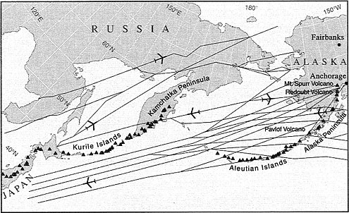
Figure 3.1 North Pacific and Russian Far East air routes pass over more than 100 potentially active volcanoes. Graphic designed by Sara Boore and Susan Mayfield.
plumes for aviation safety. There is better integration of diverse data sets, as growing numbers of VHP scientists appreciate the benefits of an interdisciplinary strategy. Finally, integrated studies of processes have provided a deeper theoretical understanding of how volcanoes work. On the negative side, the lack of new staff clearly has hindered monitoring efforts, particularly in the areas of physical volcanology, remote sensing, and gas studies. The VHP is also having a difficult time keeping up with technological advances in the core areas of deformation and seismic monitoring. Only a small number of VHP staff members know how to process GPS, InSAR, or broadband seismic data. As technology continues to improve, the VHP is in danger of being left behind; in the future it may not have the expertise to mount adequate monitoring campaigns. The VHP may want to initiate a retraining or continuing education program to allow scientists and technicians to expand their expertise.
Given this general state of affairs, one goal of this chapter is to identify weaknesses within the VHP monitoring strategy and propose needed changes. The committee believes that these problems must be addressed if the VHP is to remain capable of volcano monitoring. The status of different monitoring approaches is addressed first; then related issues, such as prioritization and access to wilderness areas, are examined.
Monitoring Approaches and Issues
Seismic and Deformation Monitoring
As magma approaches the earth’s surface, volcanoes stretch and crack in characteristic ways. The combined seismic-deformation approach, which has traditionally been the core of VHP monitoring, tracks these phenomena to provide ample warnings of impending eruptions on most volcanoes. Seismic monitoring detects earthquakes that commonly serve as eruption precursors. Geodetic techniques reveal ground surface deformation associated with the movement of magma beneath volcanoes or with the development of flank instabilities.
More than half of the potentially active volcanoes in the United States have seismic stations, and instrumenting the rest is one of the stated goals of the VHP. The report Priorities for the Volcano Hazards Program 1999–2003 (USGS, 1999) argues for an expansion of some existing networks and upgrading of overall instrument capability. The VHP also intends to improve established GPS networks that are measured sporadically with continuously recording arrays that enhance real-time forecasting. In addition, the use of permanent GPS receivers, borehole tiltmeters, and strain meters will be expanded. The committee endorses these plans because they are directly applicable to the scientific goals of the VHP and will help to achieve hazard mitigation.
Upgrading instrumentation is an ongoing challenge for any agency charged with monitoring natural phenomena. A balance is needed between preservation of traditional methods for which extensive data sets and staff expertise exist and newer approaches that require expensive retooling of instruments and personnel. The VHP faces such a quandary with regard to both seismic and geodetic data collection. Successful integration of, and migration to, new approaches will require the VHP to
prioritize—scientifically, financially, and with respect to personnel. Difficult choices will probably have to be made, such as determining the optimal distribution of broadband seismometers. The VHP must proceed carefully and systematically so that older and newer methods are maintained simultaneously during the transition. Furthermore, VHP staff members must be trained in the new techniques. For example, volcano geodesy is a rapidly expanding discipline, with many promising new methods now coming on-line. The VHP has only a few participants in these efforts and has demonstrated relatively little administrative leadership in pushing for greater involvement. This appears to be a missed opportunity that could be rectified by additional hires, greater collaborations, and more widespread training programs.
Another issue discussed at length by the committee was real-time availability of monitored information, particularly seismic and geodetic data. Freely available data in a form that is easy to comprehend help educate the public, reduce suspicion during times of crisis, and allow non-VHP scientists with different perspectives and training to contribute to the interpretation of a volcano’s status. On the other hand, unfettered access by improperly trained individuals to primary data from field instruments or remote sensing platforms could result in inaccurate interpretations, flawed policy decisions, and public panic. Although there are pros and cons for making data available on a real-time or near real-time basis, the committee believes that the advantages of public access outweigh the disadvantages. The committee therefore recommends that VHP observatories take measures to make their data available on a near real-time basis. A good example already exists at Long Valley caldera, where slightly processed USGS data have been accessible for several years on a near real-time basis as part of a World Wide Web site.
Finally, the committee was favorably impressed by AVO’s attempts to install seismic networks (either large or small) on as many Aleutian volcanoes as possible. This is critically important work, since even a small eruption can significantly disrupt North Pacific air traffic. Instrumentation efforts should be piggybacked onto other activities (e.g., hazard assessments) wherever possible to maximize the monitoring capabilities within existing budgets. The committee believes that a team approach for monitoring and studying Aleutian volcanoes from various perspectives should be expanded in the near future so that AVO can
provide airlines and other constituencies with adequate advance warning of impending eruptions.
Gas Monitoring
The collection of volcanic gas data is another essential monitoring tool that complements seismic and geodetic information. Changes in the permeability and fracture system of a volcano may be reflected in gas discharges before seismic or deformation instruments record magma ascent through newly established pathways (e.g., during the 1994 eruption of Popocatepetl, Mexico). The committee was disturbed to learn of the paucity of gas geochemical expertise and utilization within the VHP. The program should reestablish in-house capacity to use and develop both conventional and novel methods for measuring and interpreting volcanic gases. In addition, AVO has to expand its gas geochemical capabilities, rather than relying totally upon personnel at CVO. The committee notes that similar recommendations were made during an internal review of the VHP in 1986 (Shoemaker et al., 1986).
One of the priorities of the VHP is to support efforts to improve airborne and continuous ground-based techniques for quantifying gas emissions at restless volcanoes. The program also plans to better integrate seismic and geodetic monitoring with gas measurements. The committee encourages the VHP to develop and install in situ gas monitoring devices on many more volcanoes so that real-time geochemical data can be collected in conjunction with seismic and geodetic information. Continuous CO2 monitoring is currently being carried out on Mammoth Mountain at Long Valley caldera; however, the conditions there are much less harsh than in an active crater where acid gases cause corrosion and interference. The only active crater in which the VHP has routinely deployed in situ gas detectors is Kilauea, but even there, monitoring of SO2, CO2, HCl, and HF is uncommon.
New ground-based instruments for remote sensing of CO2 and other gases are currently being developed outside the USGS, including Fourier transform infrared spectroscopy (FTIR), gas correlation spectroscopy (e.g., GASPEC, MicroMaps), and light intensity detection and ranging (LIDAR) techniques. These instruments have major technical advantages over existing approaches used by the VHP. For instance, they can rapidly measure gas ratios that reflect the degassing state of magma and its
eruption potential. The committee believes that VHP scientists should be in the forefront of such efforts, either by obtaining this equipment themselves or by actively collaborating with groups who are developing these tools. Furthermore, to better understand the context in which gas readings are obtained, VHP gas personnel have to interact closely with researchers who will be using Earth Observing System (EOS) instruments (e.g., ASTER) to measure SO2 emissions from volcanoes into the troposphere.
Hydrologic Monitoring
Although less prominent in the public’s awareness than lava flows or pyroclastic phenomena, mixtures of volcanic debris and water are among the most deadly products of volcanoes. Detection of volcanic debris flows close to their sources can provide timely warnings to people in downstream areas. Many of the casualties from the Mount Pinatubo eruption were caused by debris flows that developed weeks, months, and years after the magmatic output ceased and tens of kilometers from the vent. Automated detection systems developed in the United States were installed by VDAP staff members and their Filipino collaborators, providing greater lead times for evacuations.
Several types of electronic instruments can detect and monitor debris flows at active volcanoes, but none are currently foolproof. For instance, trip wires are difficult to install and are subject to vandalism and accidental breakage. Conventional seismographs can note the passage of a debris flow but cannot pinpoint its location, nor can they distinguish such a flow from other sources of persistent noise such as rain or wind.
Scientists at CVO are currently developing two automated systems for detecting debris avalanches and debris flows. In the first, acoustic flow monitors (AFM) sense and analyze ground vibrations with a compact, solar-powered unit that is installed in specific stream channels. This can provide up to several hours advance notice of an approaching debris flow. AFM development is a prime example of how theoretical and laboratory studies can have direct bearing on monitoring capabilities because the results of flume tests and physical process models were used to refine early versions of the instruments. A second approach uses single-channel seismic sensors, pressure-transient counters, and/or lightning detectors transmitting data via low-baud-rate Geostationary
Operational Environmental Satellites (GOES). This system identifies the onset of activity in places where network coverage or visual confirmation is limited or impractical.
Over the next five years, the VHP plans to improve and field-test remote eruption detection stations for possible deployment in the western Aleutians and the Cascades. The committee supports this goal because it is relevant to the VHP mission to mitigate volcano hazards. The VHP should also explore ways to better monitor groundwater flow and pore pressures within volcanic edifices. This type of information could help establish the potential for phreatic and phreatomagmatic activity, sector collapse, and internal pressure buildups capable of generating explosive blasts. Such hydrologic monitoring warrants greater attention by the VHP. The incorporation of glacier budget studies as part of VHP monitoring on ice-clad volcanoes would also contribute to this goal.
Satellite Remote Sensing
Another VHP goal that the committee fully supports is the continued development of near real-time remote sensing of volcanoes and their associated ash clouds in areas that are difficult to access. Most of the VHP’s remote sensing work is centered at AVO, where satellite data are used to identify thermal anomalies and track eruption plumes and where inclement weather makes traditional observations of volcanoes more difficult. Remote sensing data are only slowly becoming integrated into the monitoring strategies of the other VHP observatories, primarily because of a lack of resident expertise.
A new generation of EOS instruments is now providing potentially useful information for volcano monitoring (e.g., data on thermal regimes, SO2 gas emissions, deformation, and digital topography). The committee believes strongly that the VHP should take advantage of this opportunity to the fullest extent possible, through two steps: (1) Expand the remote sensing program at AVO and officially designate it as the center of internal expertise for the VHP. In this manner, other observatories will gain access to these tools without having to hire as many of their own specialists. A secondary benefit will be to reduce the sense of isolation felt by AVO personnel relative to the rest of the VHP, especially if training sessions for mainland and Hawaiian colleagues are held at AVO. (2) Forge stronger links with universities and government laboratories
where such expertise is available and where many new techniques are being developed. In particular, the committee urges the USGS to work with NASA to argue in support of an InSAR satellite specifically designed for hazards monitoring (Sidebar 3.2). However, the major funding needed for development and deployment of such a satellite cannot come out of the VHP budget. Other federal agencies are also striving to expand their use of remote sensing capabilities, and this offers additional partnering opportunities to the VHP. For instance, the U.S. military became much more sensitive to volcanic dangers during the 1991 eruption of Mount Pinatubo. The Navy’s Pacific fleet (under supervision of CINCPAC (Commander-in-Chief, U.S. Pacific Command)) now monitors the status of all types of natural disasters around the Pacific Rim, in part through the efforts of the Pacific Disaster Center (PDC). The PDC is a federally funded facility with the mandate to provide disaster managers with value-added information on all types of natural and human-made disasters. Although it has excellent remote sensing and geographic information system (GIS) capabilities, the PDC has limited volcanic expertise in terms of monitoring and numerically modeling the many different types of eruptions that create hazards around the Pacific and Indian Oceans. Encouraging more coordination between the remote sensing activities of the PDC and volcanic monitoring by HVO, AVO, and CVO would likely benefit both groups. Other agencies that could gain from an enhanced VHP remote sensing presence include Federal Emergency Management Act (FEMA) and the FAA. Another potentially promising remote sensing partner for the VHP is the Global Disaster Information Network (GDIN), which is expected to evolve a global perspective for natural hazard monitoring comparable to the PDC’s role around the Pacific and Indian Oceans.
The committee also considered the potential value to volcano monitoring of two existing remote sensing programs based outside the VHP, the Hazard Support System (HSS) and the Center for Integration of Natural Disaster Information (CINDI). The HSS is designed to use classified military “spy” observations for civilian purposes. Beginning in FY 2000, this program will be partially funded by the National Mapping Division of the USGS. A single senior VHP member in Reston, Virginia serves as liaison to HSS, helping to find ways to use these data for volcano monitoring. CINDI is an unclassified USGS facility that develops and evaluates technology for information integration and dissemination.
|
SIDEBAR 3.2 Yellowstone National Park holds a very large and restless caldera, which formed approximately 630,000 years ago through the ejection of about 1,000 km3 of debris. Explosive activity was followed by rhyolitic lava flows extruded from 150,000 to 70,000 years ago. Although Yellowstone caldera has remained dormant since then, geological and geophysical evidence suggests that an underlying crustal magma reservoir remains partially molten because of periodic intrusions of basalt. Since another caldera-forming eruption is possible, a continuous monitoring program is maintained by the VHP in conjunction with academic scientists. A variety of geological and geophysical field studies in the past 20 years have revealed that Yellowstone has experienced uplift and subsidence of its caldera floor in historic and prehistoric times. Recently, InSAR data from the European Space Agency have been used to dramatically pinpoint the deformation of the entire caldera floor (Wicks et. al., 1998). The interferogram on the left, made from data collected between August 1992 and June 1995, shows about 60 mm of subsidence. The one on the right, based on data from July 1995 and June 1997, indicates 30 mm of uplift.  The great promise of InSAR is that it requires no ground-based presence. Thus, precise monitoring can be effected without placing scientists or technicians in harm’s way. Furthermore, there is no need to establish ahead of time which volcanoes are going to become active. InSAR potentially allows practically all volcanoes to be monitored. However, none of the existing or planned SAR systems is optimally designed for volcano monitoring. |
CINDI is also involved in research in data integration, analysis, and modeling and provides ongoing support of the evolution of the USGS processing and delivery of hazards data.
Although these programs have clear promise for monitoring and have been strongly promoted by some non-VHP members of the USGS, the committee heard two primary reservations expressed by several VHP scientists. The classified nature of some of the data and the fact that military priorities control which observations are made mean that VHP personnel may have limited access, controlled by the Department of Defense. This adds an extra bureaucratic layer of communication and interpretation, slowing responsiveness and potentially reducing the effectiveness of the monitoring effort. Second, because these programs are very expensive, they run the risk of draining sparse resources away from the VHP for questionable returns. For these reasons, the committee cautions against greater involvement with CINDI and HSS unless and until better assurances can be obtained about data access and cost containment. A potentially less problematic alternative would be to establish closer ties with the nonclassified EOS program run by NASA. To best incorporate satellite- and aircraft-based remote sensing programs such as EOS into its monitoring mission, the VHP should expand partnerships with academia, other government agencies (e.g., NASA, NOAA), and private sector groups. Caution should be exercised in placing too much reliance on classified remote sensing data.
Other Monitoring Issues
Prioritization of Monitoring Activities
The scientific value of basic monitoring is often underappreciated, yet the resulting data provide the framework with which new ideas are developed and tested, models constructed, and forecasts made. Just as with hazard assessment, the type of monitoring that is done by the VHP at a particular observatory depends in part on the experience and biases of the people who work there. A less ad hoc approach would include objective, program-wide evaluation of new techniques followed by observatory-wide decision making by the scientists in charge or by a committee of users. Any new techniques for data evaluation must be downward compatible, so that older data sets remain available for future
studies. Better communication among the different scientists in charge or other representatives helps ensure that all observatories learn of the latest monitoring technologies in a timely fashion. This practice would be more “top-down” than current procedures and would potentially reduce the autonomy of individual scientists and observatories.
Prioritization across government agencies would also help the VHP with its monitoring mission. Regular interactions between the scientists in charge and representatives from other science-oriented agencies, such as NASA, NOAA, DOE, FEMA, and the NSF, would allow for coordination of expenditures and extramural grant funding related to monitoring activities. These meetings would also let the scientists in charge notify their counterparts about the types of information the VHP needs to improve monitoring for public safety. For instance, if U.S. Forest Service and National Park Service managers were included in these discussions, they might better appreciate why VHP scientists need occasional vehicular access to otherwise off-limits wilderness areas (see next section).
Access to Wilderness Areas
Many volcanoes in the Cascades and several in Alaska lie within wilderness areas and other lands managed by the National Park Service and the U.S. Forest Service. This situation creates a conflict between the need for effective monitoring in order to serve public interests and the desire to minimize mechanized access to the areas in question. The use of four-wheel-drive vehicles or helicopters to install and maintain monitoring equipment has been greatly restricted under interpretations of the Wilderness Act. Recent events have led members of the scientific community to assert that “there is no clear policy on research in parks and wilderness” (Eichelberger and Sattler, 1994; Eichelberger, 1997). Clearly, this is a delicate situation that must be resolved by effective communication among the different agencies involved. The problem requires that scientists in charge of the observatories maintain a close working relationship with their counterparts in nearby National Parks and National Forests. Hawaii Volcanoes National Park provides a useful example of a flexible policy, which in part grew out of recognition by the communities situated near active volcanoes of the importance of good access for monitoring. High-level administrators within the USGS and
other organizations must actively campaign to gain recognition that monitoring efforts require special attention and priority.
SUMMARY
Persistent budget problems place four types of constraints on the VHP’s ability to monitor volcanoes. (1) Aging equipment is not replaced soon enough (or at all), which increases the chances of failure during a crisis. (2) The VHP’s traditional role as the developer and tester of new monitoring equipment and techniques is jeopardized. (3) The number and extent of regular instrumented surveys, which are crucial for the success of any monitoring program, are restricted. (4) Personnel familiar with new techniques are not hired. If the current situation is not reversed, the VHP may not be able to field the best instruments or maintain its traditional high standards for monitoring. These issues apply in varying degrees to all of the monitoring methods used by the VHP, and if they are not addressed in the near future, the program runs the risk of being unable to meet appropriate scientific goals. On the other hand, the monitoring methods currently employed in the VHP seem to be well integrated and applied to achieve hazards mitigation.


