
The Scientific Potential of Seafloor Observatories
The varied scientific presentations at the workshop demonstrated the significant potential of observatory science. Areas where time-series data collected from seafloor observatories would advance research include:
-
Studies of episodic processes—Episodic processes include eruptions at mid-ocean ridges, deep-ocean convection at high latitudes, earthquake swarms at subduction megathrusts, and biological, chemical, and physical impacts of episodic storm events. These processes can be anticipated only in a statistical sense; accurate prediction of the timing for an individual event is not possible. Lower-complexity mooring-based observatories are beneficial for the study of episodic processes, as they provide a lower-cost system for deployment in anticipation of or in the aftermath of an episodic event.
-
Process studies for periods of months to several years—The ability to deploy an observatory in remote locations to investigate oceanographic processes occurring on timescales of months to years is a critical need of the oceanographic community. These processes include hydrothermal activity and biomass variability in vent communities along portions of the mid-ocean ridge system, air-sea interactions in the Southern Ocean, and biological and chemical variability of the water column at both coastal and oceanic sites.
-
Observations of global and long-term processes—Moored observatories will be essential for the establishment of an observatory network to investigate global processes, such as the dynamics of oceanic lithosphere and thermohaline circulation. These moored systems would also
-
provide long-term capabilities in remote regions where cabled observatories are unavailable or would be prohibitively expensive to install.
The sections in this chapter summarize the discussions and scientific outcomes of breakout groups organized according to the six National Science Foundation (NSF) decadal report themes based on the “Futures ” workshops (Baker and McNutt, 1996; Jumars and Hay, 1999; Mayer and Druffel, 1999; Royer and Young, 1999). Each section addresses future directions and major scientific problems, the role of sustained time-series observations, and technical requirements for seafloor observatories. Boxes describing currently active observatory or time-series experiments have been included where they are appropriate to the science being discussed. In addition, tables (developed based on symposium discussions) have been added to each section, highlighting areas where observatories are “very useful” in investigating a scientific problem, and where they are “useful.” The term “very useful” is used to categorize scientific problems for which long-term, time-series datasets collected at seafloor observatories will result in substantial scientific progress that will either not be possible using a traditional expeditionary approach or can only be accomplished with limited success using more traditional means. “Useful” is used to categorize those scientific problems for which an observatory approach will provide a valuable complement to other more traditional research strategies.
ROLE OF THE OCEAN IN CLIMATE
Climate variations have widespread societal, economic, and environmental impacts. As a result, vigorous research efforts are currently aimed at improving understanding of the spectrum of climate system variations, discovering potentially predictable elements, and exploiting that potential. For example, El Niño/Southern Oscillation (ENSO) forecasts have demonstrated both the potential and the value of climate prediction.
The ocean is an intrinsic component of Earth's climate system, playing an increasingly important role in determining the nature of climate variability as timescales increase. Researchers seek to improve our understanding of the role of ocean heat storage, transport, and release in the coupled ocean-atmosphere-land climate system, and of the interactions of oceanic biogeochemistry with the climate system (Boxes 2-1 and 2-2).
FUTURE DIRECTIONS AND MAJOR SCIENTIFIC PROBLEMS
Ultimately, we seek to predict climate variability and change. This requires accurately predicting the evolution of the ocean (especially near-surface temperatures) when changes in atmospheric forcing occur. Despite impressive
progress with forecasting seasonal-to-interannual evolution associated with ENSO events, there is considerable room in these and longer timescales for improvement in the observation, analysis, and assessment of predictability of the oceanic component of the coupled climate system. For example, it is now clear that Pacific decadal climate variability influences ENSO, and it is possibly strongly coupled to ENSO. Research has conclusively shown that the ocean exerts an important influence on decadal climate variability, but details of its role are unclear. Several hypotheses have been developed to explain the sparse oceanographic observations and climate model behavior. Another example involves the North Atlantic Oscillation influencing ocean physics on decadal time scales, such as Labrador Sea wintertime deep convection and the path of the Gulf Stream extension. Limited observations and models suggest that there is a feedback of the resultant ocean variability onto the atmosphere.
An important problematic challenge before us is separating natural interannual-to-centennial climate variations from anthropogenically induced climate change. This understanding is critical for predicting future variations and magnitudes of climactic change.
For both hypothesis testing and prediction purposes, we rely increasingly on models of the climate system. Even though the present generation of ocean general circulation models are much improved, representation of important ocean physics is still crude. A substantially improved observational basis for determining the needed model enhancements is required. Specific ocean science challenges include quantifying and understanding turbulent mixing; convection; water-mass formation and destruction; thermohaline circulation and its coupling to the wind-driven circulation; the generation, maintenance, and destruction of climatic anomalies; climatic oscillations and the extratropical coupling of the ocean and atmosphere on seasonal, decadal, and interdecadal timescales; and the physics of exchange processes between the ocean and the atmosphere (Royer and Young, 1999).
The U.S. scientific community has played an important role in shaping and is actively participating in the World Climate Research Programme 's Climate Variability and Predictability (CLIVAR) program in order to address the challenges outlined above (NRC, 1994a; NRC, 1996a; NRC, 1998b; NRC, 1998c). CLIVAR scientists have worked with other ocean programs to develop plans for a global ocean-observing system that will meet the research requirements for major advances in understanding the role of ocean processes in the climate system and will provide a basis for predictability research (NRC, 1994b; NRC, 1997).
THE ROLE OF SUSTAINED TIME-SERIES OBSERVATIONS
Oceanographic variability has a significant influence on climate. Because of nonlinear scale interactions, it is essential for the study of climate to fully
|
BOX 2-1 THE HAWAII OCEAN TIME-SERIES Objectives: The Hawaii Ocean Time-series (HOT) objectives are to document seasonal and interannual variability of water masses in the North Pacific Ocean subtropical gyre; to relate water mass variations to gyre fluctuations; to develop a climatology of short-term variability; to document and understand seasonal and interannual variability in the rates of primary production, new production, and particle export from the surface ocean; to determine the mechanisms and rates of nutrient input and recycling, especially for nitrogen and phosphorus in the upper 200 m of the water column; to measure the time-varying concentrations of dissolved inorganic carbon in the upper water column; and to estimate the annual air-to-sea carbon dioxide flux. To achieve these objectives, biogeochemical and physical observations are collected monthly or near-monthly during three-day shipboard occupations of Station ALOHA. A subsurface sediment trap mooring is maintained at ALOHA, along with a surface mooring with meteorological, bio-optical, and physical sensors approximately 40 km away. A coastal station (Kahe Point) is also sampled during most cruises. Information is provided in Karl and Lukas (1996). Additional information on the HOT time-series can be found at http://hahana.soest.hawaii.edu/hot/hot.html (HOT, 2000). Location: Station ALOHA is located 100 km north of Oahu in 4,740 m of water. The Kahe Point station is about 10 km offshore in water depth of about 1,500 m (Figure 2-1). Established: HOT was established in late 1988 with National Science Foundation funding under the auspices of the Joint Global Ocean Flux Study (JGOFS) and World Ocean Circulation Experiment (WOCE) programs The surface mooring was first deployed in early 1997 |
resolve many scales of variability, and the consensus is that this will require nested, complementary observing systems (Table 2-1). In particular, the vision that is developing for an ocean-observing system for climate consists of a number of highly instrumented fixed sites around the world, a larger number of fixed sites of lesser capability, and a global array of Lagrangian samplers, all working in concert with global satellite remote sensing and global data assimi
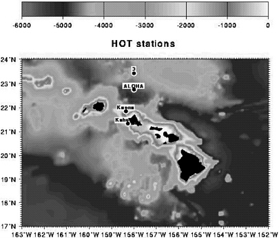 FIGURE 2-1 Locations of HOT sampling stations with water depth indicated by the grayscale defined above (Lukas and Karl, 1998). |
lative modeling. Fixed site observatories would primarily consist of moorings, which are best suited for vertical and temporal sampling. Moorings also provide the means to sample scientifically critical regions, such as the upper few tens of meters of the ocean under ice cover in confined current systems and in abyssal layers (including bottom boundary layers; see “Turbulent Mixing and Biophysical Interaction” section in this chapter).
|
BOX 2-2 BERMUDA ATLANTIC TIME-SERIES STUDY Objective: The Bermuda Atlantic Time-series Study (BATS) commenced monthly sampling in the western North Atlantic subtropical gyre as part of the U.S. Joint Global Ocean Flux Study (JGOFS) program in 1988. The goals of U.S. JGOFS time-series research are to better understand basic processes controlling ocean biogeochemistry on seasonal to decadal timescales, to determine the role of the oceans in the global carbon budget, and ultimately to improve our ability to predict the effects of climate change on ecosystems. The BATS uses a monthly shipboard sampling scheme to resolve seasonal patterns and interannual variability. Core cruises last four to five days during which hydrography, nutrients, particle flux, pigments and primary production, bacterioplankton abundance and production, and complementary ancillary measurements are made. This study also incorporates data from nearby Hydrostation S, the Ocean Flux Project, and the Bermuda Testbed Mooring (BTM). Hydrostation S, established in 1954, is one of the longest-running oceanic and atmospheric time series. All of the data from the BATS program and many of the data from the Hydrostation S and BTM are available publicly at the Bermuda Biological Station for Research home page at http://www.bbsr.edu (and then following the links to the BATS data). Location: The BATS station lies 82 km southeast of the island of Bermuda (31 ° 40' N, 64° 10' W) in the Sargasso Sea, approximately 1,200 km from the east coast of the United States (Figure 2-2). Bottom depth at the BATS deployment area is ~4,680 m. Established: Monthly sampling commenced in October 1988. |
In addition, observatories, together with other elements of the nested observing system (such as Lagrangian samplers and satellites), provide the physical oceanographic context for interpreting biological and chemical distributions.
Considerable planning for observatory-based science necessary for climate research has been conducted by the oceanographic community. The Ocean Observing System Development Panel (OOSDP) developed the scientific basis for global ocean observations for climate and prioritized the observations that would be made (Nowlin, 1999). The Ocean Observing Panel for Climate
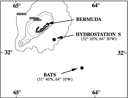 FIGURE 2-2 Location of the BATS sampling station. SOURCE: Deborah K. Steinberg, Bermuda Biological Station for Research. |
(OOPC) is moving toward implementation of the OOSDP recommendations.OOPC and other groups representing climate research interests hosted a major international conference, OceanObs99, in St. Raphael, France, in October 1999 (OCEANOBS99, 1999); the conference gathered broad input from the ocean science and climate communities and helped further the scientific rationale for sustained observations.
At present, we have very few sustained observing sites supporting research on the role of the ocean in climate. To further our understanding of the role of
TABLE 2-1 The Role of Ocean in Climate: Areas Where Observatories Are Very Useful to Investigate a Particular Scientific Problem and Where They Are Useful
|
Observatory science is VERY USEFUL in accomplishing the following:
Observatory science is USEFUL in investigating the following:
|
the ocean in climate, seafloor observatories should be long-term (outliving individual investigator proposals), shared-use facilities that sustain climate community measurement goals while allowing technology to evolve. A fundamental change achieved by pursuing the observatory concept would be maintenance of existing sites and establishment of new sites. This may be the key to moving from our current focus on long-term science projects, such as CLIVAR (which may result in 5- to 10-year time series), to the implementation of a sustained global ocean-observing system.
TECHNICAL REQUIREMENTS
The technical requirements of the climate and turbulent mixing communities have an important overlap, and there are compatible needs for platforms. The strategy of nested, complementary elements of an observing system is shared, and it is agreed that fixed observatories are uniquely able to support the required observations.
For the climate-science issues discussed above, the objectives do not, in general, require high power (present systems work at 5 W and less) or high data rates (tens to hundreds of numbers are now sent back per hour or per day). Long-range acoustic tomography requires more power (approximately 200 W) for driving acoustic sources. Acoustic tomography also produces large volumes of data that are not presently relayed using real-time telemetry.
The availability of ocean observatory sites around the globe that could provide power and access to data telemetry and two-way communication would enable the climate and mixing communities to make greater progress toward their science goals. Furthermore, at the symposium, it was noted that the map of Global Eulerian Observatory (GEO) sites produced by the OceanObs99 climate conference had a number of sites close to sites proposed for the Ocean Seismic Network (OSN) (Plate II). This synergy emphasizes the need for a dialog between proponents of observatories for different science goals to maximize mutual benefits and to explore how observatory sites occupied for other reasons could enable further progress in climate and mixing research.
Sites shown on Plate II fall into the category of global observatories, and would be key elements of the nested, complementary network required for global ocean observations for climate studies. These are viewed as relatively high-power, high-capability sites that would provide opportunities for instrument integration, data access, and a surface expression. Their design minimize radio frequency contamination of sensors, shadowing of sunlight, disturbance of flow in the atmosphere and ocean, and biological and chemical contamination of the ocean and atmosphere. The mooring design should also permit the storage and release on demand of garage floats, autonomous underwater vehicles (AUVs), weather balloons, and other autonomous instrument packages. These high-capacity sites would become focal points for multi
disciplinary oceanographic science and should contain a standard suite of instrumentation including bottom-pressure sensors; inverted echo sounders; electric-field sensors; temperature, salinity, velocity, surface meteorological, optical, and aerosol systems; and sensors to measure key chemical, optical, and biological parameters.
Relocatable observatories consisting of one or more moored platforms would be highly valuable for climate-related process studies involving turbulent mixing, air-sea exchange, biochemistry, coupled upper-ocean optics, etc. Different types of relocatable observatories should be considered for investigating specific science questions. These could be repositioned for one or more years at different locations around the globe as needed, such as proposed for surveying turbulence parameter space in the “Technical Requirements” of the “Turbulent Mixing and Biophysical Interaction” section. Relocatable observatories should have power available along with data transmission capabilities. There was interest expressed at the symposium in taking relocatable observatories to extreme environments (for example, areas with high wind speeds) and data-sparse regions where significant impact on climate science would be anticipated. Further development of moored turbulence sensors is needed for use on relocatable observatories.
Permanent cabled observatories are of interest as sites where multidisciplinary “laboratories” could be developed. Of particular interest would be efforts to fully image a three-dimensional (3-D) volume in the ocean, resolving the time and space variability of the physics, biology, chemistry, and geology on scales from centimeters to kilometers (the 3-D aspect is discussed in more detail in the “Turbulent Mixing and Biophysical Interaction” section). Such observatories should have the physical infrastructure to permit growth and easy addition of new users and instruments.
FLUIDS AND LIFE IN THE OCEANIC CRUST
The chemistry and biology of fluids within the oceanic crust is a cutting-edge research field for which seafloor observatories are thought to be a needed investigative approach (Table 2-2). One of the most exciting scientific problems that can be addressed using observatory science concerns the nature of the subsurface biosphere, thought to contain a population of dormant microbes that are periodically driven into a population explosion by input of heat and volatiles into the crust during magma emplacement events (Boxes 2-3 and 2-4; Delaney et al., 1998; Summit and Baross, 1998). In addition to the ridge crest and flanks, a population of microbes is also thought to exist in the extreme environment of subduction zones sustained by either continuous or episodic input of energy and nutrients (Cragg et al., 1995). Another exciting and closely related scientific problem concerns the general response of the hydrothermal system and associated biota to seafloor spreading events in which magma is
TABLE 2-2 Fluids and Life in the Oceanic Crust: Areas Where Observatories Are Very Useful to Investigate a Particular Scientific Problem and Where They Are Useful
|
Observatory science is VERY USEFUL to investigate the following:
Observatory science is USEFUL to investigate the following:
To address the science where observatories are very useful, development or improvement of the following sensors is needed:
|
injected into the crust. This research would include the response of seafloor biological communities at convergent margin seepage sites to abrupt changes in fluid and chemical fluxes caused by seismic activity. Similarly, the dynamics of gas hydrate formation and dissociation, especially in response to perturbations produced by tectonic cycles or global warming, is a problem of current interest that could be addressed by observatory science.
FUTURE DIRECTIONS AND MAJOR SCIENTIFIC PROBLEMS
Four different oceanic environments are important for research on fluids and life in the ocean crust: ridge crests, ridge flanks, convergent margins, and coastal areas on passive margins. The ridge-crest environment can be further subdivided into sedimented versus non-sedimented ridges, magma-rich versus
|
BOX 2-3 OBSERVATORY SCENARIO: FLUID DETECTION, OBSERVATION, AND RESPONSE TO A SEAFLOOR VOLCANIC ERUPTION Eruptive events on the seafloor have the ability to release great volumes of hydrothermal fluid that affect the chemistry and biology of overlying water and generate a unique type of hydrothermal plume called an event plume (Figure 2-3). Although it is not known how event plumes are formed, it is clear that they are produced by a sudden catastrophic release of large quantities of hot water. Eruptions also extrude lava on the seafloor, creating new habitats for endemic vent faunas and increasing production and export of deep-living microbial populations. Initial changes in water-column and seafloor properties after an eruptive event are very difficult to study using expeditionary approaches, although recent event detection and response efforts at Juan de Fuca Ridge have made good progress toward this end. A seafloor observatory system near a volcanically active site would provide an important platform for characterizing the early stages of an event while also monitoring longer-term changes. For instance, once an eruptive event has been detected (acoustically or otherwise), sensors in the water column and near the seafloor could increase data collection and transfer rates. An Autonomous Underwater Vehicle (AUV) could then be released to image the seafloor at the eruption site to record geochemical and biological characteristics of the water column and benthos. Drifters could also be released from the observatory node to track the event plume as it was advected from the site, and could measure the changes in geochemistry, particulates, and organisms as the plume evolved. On longer timescales, a Remotely Operated Vehicle (ROV) could be mobilized to initiate experiments and collect samples at the eruption site. |
magma-starved ridges, and ridges recently perturbed by magma input versus ridges in a mature or quiescent state. Similarly, the subduction zone environment can be further subdivided into convergent margins with sediment accretion versus sediment subduction, fast versus slow subduction rates, and sediment type (terrigenous versus marine). The ridge-flank environment can be categorized according to the nature and thickness of sediment cover, and association with fast or slow spreading ridge. Within each of these environ
|
BOX 2-4 NEW MILLENNIUM OBSERVATORY Objective: The objective of the New Millennium Observatory (NeMO) is to monitor and sample geophysical, geochemical, and microbial variability on an active segment of a mid-ocean ridge system for determination of the relationships between subseafloor magma movement; faulting; and changes in the biologic, chemical, and physical properties of the subsurface biosphere (Figure 2-3). Instrumentation deployed includes acoustic range meters (extensometers), high-and low-temperature probes, osmosamplers, time-lapse cameras, seafloor pressure gauges, microbial traps, and seafloor navigation transponders. Location: Axial seamount (summit caldera at 1,520 m water depth) on the Juan de Fuca Ridge, approximately 250 mi off the coast of Oregon and Washington Established: Autumn 1997  FIGURE 2-3 Axial Volcano, Juan de Fuca Ridge—the first place where new tube worms were found on the site of the 1998 Axial Volcano seafloor eruption. It is near the edge of the lava flow (note the new lava in the background). Photo taken in 1999. SOURCE: National Oceanic and Atmospheric Administration Vents Program. |
ments, it is critical to determine the nature of and the linkages between tectonic, thermal, chemical, and biological processes at a variety of temporal and spatial scales to achieve an in-depth scientific understanding of the processes that are occurring.
The following are some of the important scientific goals for future research that can be addressed with seafloor observatories:
-
assess the extent of the sub-seafloor biosphere and determine its biological and chemical character;
-
assess the impact of fluid and gas flow and related processes on crustal structure and composition, ocean chemistry, and biological productivity within and above the seafloor;
-
determine the fluid flow patterns on ridge crests, ridge flanks, and in convergent margins through space and time;
-
directly observe the changes in heat, chemical fluxes, and biological diversity produced by ridge-crest magmatic and tectonic events;
-
determine how hydrothermal-event plumes (megaplumes) form and assess their global importance;
-
directly observe how biological productivity and diversity change in response to fluctuations in fluid and chemical fluxes at vents and seeps on ridge crests, ridge flanks, and at convergent margins;
-
assess the extent to which sediment cover and spreading rate or subduction rate affect fluid chemistry and biological diversity at ridge crests, ridge flanks, and subduction zones and assess the impact of these chemical systems on the overlying ocean;
-
quantify the importance of chemosynthetic productivity on the seafloor;
-
understand the relations between tectonic and fluid processes in subduction zones;
-
determine rates of gas hydrate formation and dissociation in response to perturbations of pressure, temperature, and fluid chemistry and flow rate and determine the influence on ocean chemistry, biology, and climate.
THE ROLE OF SUSTAINED TIME-SERIES OBSERVATIONS
Previous observations of fluids related to the ocean crust have been made mainly by deploying single, short-duration experiments that stored data rather than transmitted information in real time. To make significant advances in this area of research, it is essential to observe co-varying processes by making synoptic1 measurements over a variety of timescales. The ability to simulta
|
1 |
Synoptic - large-scale simultaneous collection of measurements or observations. |
neously conduct a variety of sustained time-series measurements will greatly aid the understanding of linkages between geological, chemical, physical, and biological processes. Furthermore, real-time availability of data is essential, as it will allow scientists to respond to unusual events or modify experiments if necessary. Seafloor observatories could also provide valuable real-time control of experiments and allow in situ process studies in which intervention or perturbation experiments could be conducted. On a broader scale, a more ambitious goal would be to design an observatory that could provide simultaneous observations on the ridge crest, ridge flank, and convergent margins. This would provide crucial new insights and understanding of the linkages among these different environments.
TECHNICAL REQUIREMENTS
For future studies of fluids and biota in the oceanic crust, access to the subsurface is a critical requirement. One way to sample and observe fluids and biota in the crust is by drilling, and ideally some seafloor observatory experiments would be conducted in conjunction with boreholes drilled into the crust (Box 2-5). Thus, the continuation of the Ocean Drilling Program and the development of new drilling capabilities will be an essential adjunct to seafloor observatory studies.
The ability to respond rapidly to magmatic and tectonic events is another critical need that necessitates relocatable seafloor observatory capabilities that can be rapidly deployed when an event is detected by remote sensing, such as acoustic detection using submarine hydrophones. Another approach might involve the use of AUVs, already in place at docking stations, that could be called into service to conduct water-column surveys and photoreconnaissance of an event locality. Rapid response is also dependent on continued real-time acoustic monitoring, such as that presently provided by the SOund SUrveillance System (SOSUS) array.
Another important goal is to properly configure an observatory or network of observatories to simultaneously monitor changes on the ridge crest, the ridge flank, and at the convergent margin in real time. This would provide direct observations of the linkages between these different environments and would also allow observations of the entire hydrologic cycle associated with seafloor spreading, from the trapping of fluids in the crust on the ridge crest and ridge flank, to the dewatering of crust and gas hydrate formation and dissolution at convergent margins.
The development of new sensors and observational tools for long-range monitoring in a variety of environments is essential for the observatory approach to be effective. There is a critical need for new chemical, flow-rate, and biological sensors, and also for improved camera systems that are immune
|
BOX 2-5 BOREHOLE CIRCULATION OBVIATION RETROFIT KITS From 1991 to 1997, the Ocean Drilling Program installed 13 long-term hydrogeological observatories or Circulation Obviation Retrofit Kits (CORKs) to study fluid flow processes in situ in two documented flow regimes: sedimented young oceanic crust and accretionary prisms. These observatories involve sealing a borehole at the throat of the reentry cone with a sensor string suspended in the hole. A long-term data logger is positioned so that it is accessible by a submersible at the seafloor for periodic data transfer and reprogramming. Long-term records of borehole temperature and pressure indicate that months or even years were required to reestablish fluid conditions exiting in the formation prior to drilling. Borehole temperature and pressure records also captured the signals of hydrologic transients and nearby earthquakes, and allowed the fluid transport and elastic properties of the CORKed formation to be determined at multiple scales using the spectral analysis of phase and attenuation of seafloor tidal-loading signals that propagate into the subsurface. Some CORKs also incorporate valves on the seafloor to access the sealed hole either for direct hydrological testing of the formation or fluid sampling for geochemical and microbiological analysis. Most of the sites instrumented with CORKs do not produce formation fluids at the valve, and have required deployment of long-term, self-contained, osmotically driven “osmosamplers” on the sensor strings for recovery of in situ fluids. Hole 1026B on the Juan de Fuca Ridge (Plate III) is an example of a site where crustal fluids are actively produced. This hole was drilled into a topographic high with a permeable basement that focuses circulation of subsurface fluids. This site generated considerable excitement as the location of a long-term, microbiological filtering experiment deployed for over two years by a team from the universities of Hawaii and Washington. The successes of the original CORK hydrogeological observatories made a significant contribution to the in situ monitoring of geological processes. Building on these successes, a new generation of advanced CORKs has been developed, incorporating a capability to separately seal and isolate multiple zones in the sub-seafloor formation, so the observatory configurations correspond much more closely to natural hydrogeological structures. This new generation will also accept an enhanced range of sensors and auxiliary experiments, allowing customized sub-seafloor observatories for studying a variety of fluids-related problems (e.g., sub-seafloor microbiological communities and processes, gas hydrate processes) or seismogenesis and the balance among tectonic and fluid-flow processes at plate boundary faults. |
to biofouling. For studies of subsurface fluids and biota, new downhole sensors and experimental packages are needed for borehole deployment.
Biological studies within the crustal and vent environments will necessitate a wide range of experiment types that in turn will require different observatory approaches. To study the biological response to transient events, such as the colonization of newly formed vent fields, relocatable observatories that can be rapidly deployed are essential. In contrast, at sites exhibiting relatively stable behavior, biological experiments will require a permanent or long-term observatory with high-bandwidth data transmission for high-quality video and other types of monitoring.
DYNAMICS OF OCEANIC LITHOSPHERE AND IMAGING EARTH'S INTERIOR
Increasingly, geoscience research in the oceans is moving beyond the exploration and mapping of the seafloor and is focusing on understanding the dynamics of the solid earth system and the interaction of geological, chemical, and biological processes through time. The expeditionary approach common in the ocean sciences in the past, in which seagoing investigations were conducted in regions for short time periods, is poorly suited for detecting or understanding longer-term change. A continuous measurement presence is required with the ability to react quickly to episodic events, such as earthquakes or volcanic eruptions (Table 2-3). Long-term observations are also needed for making measurements of signals with poor signal-to-noise ratios, or measuring change that is only resolvable over long time periods, such as the motion or internal deformation of lithospheric plates. Geophysical observatories have long been an integral component of earth science research on land; advances in technology and our understanding of the oceans now make it feasible to establish long-term observatories on the seafloor (Boxes 2-6 and 2-7).
MAJOR SCIENTIFIC PROBLEMS AND ROLE OF SEAFLOOR OBSERVATORIES
There are many areas of earth science research that would be advanced through the collection of sustained time-series observations on the seafloor. These include:
Global earth structure and core-mantle dynamics—Fundamental scientific questions currently exist concerning the dynamics of Earth's mantle and core. Until only a few years ago it was generally accepted that subducting slabs penetrated no deeper than the 670 km discontinuity. New results suggest that some slabs descend into the lower mantle, possibly to the core-mantle boundary. This has reopened fundamental questions about the scales of con
TABLE 2-3 Dynamics of Oceanic Lithosphere and Imaging the Earth's Interior: Areas Where Observatories Are Very Useful to Investigate a Particular Scientific Problem and Where They Are Useful
|
Observatory science is VERY USEFUL to investigate the following:
Observatory science is USEFUL to investigate the following:
To address the science where observatories are very useful, development or improvement of the following sensors is needed:
|
vection in Earth's mantle (layered versus whole mantle) and the existence and origin of distinct mantle geochemical reservoirs. These topics will be major focuses of future research.
The nature and origin of hotspots and their interaction with the lithosphere are other important questions in mantle dynamics. New paleo-magnetic data are inconsistent with the idea of “fixed” hot spots and geochemical data appear to be compatible with a variety of different origins for hot spots, including the 670 km discontinuity, a boundary between different geochemical reservoirs in the lower mantle, or the core-mantle boundary (CMB). The CMB is compositionally and perhaps dynamically the most dramatic boundary within the earth and it has been proposed as the origin of hot spots and the graveyard of subduction zones. Future studies will be aimed at determining the role of the CMB in the larger-scale dynamics of Earth's mantle.
The earth's inner core, which comprises less than 1 percent of Earth's volume, is the last frontier of solid-earth geophysics. Data that sample this region must travel through the remaining 99 percent of Earth's volume; thus,
all of the errors introduced by correcting for the “known 3-D structure of the mantle” project themselves onto the inner core. There are indications that the properties of this region are more complex than previously thought, and as our knowledge of mantle heterogeneity improves so will our resolution of the structure of Earth's inner core.
Four centuries after the demonstration by Gilbert that Earth's magnetic field is largely of internal origin, our understanding of the dynamo process responsible for generating the field remains incomplete. The abundance of data from direct observation of the field over historical time periods, and in particular over recent periods from satellites and permanent land observatories, enables the field to be mapped with far greater resolution than could possibly be realized with paleomagnetic observations. There is a growing recognition from these data that it is the behavior of the field on very short timescales— from decadal to annual periods—that lies at the heart of some of the most important problems in geomagnetism.
Improved spatial sampling provided by long-term seismic and geomagnetic observations in the ocean promises great gains in understanding the geodynamics of Earth's interior and the origin of Earth's magnetic field. Large gaps exist in the global network of seismic and geomagnetic stations that cannot be filled with island stations, particularly in the remote eastern Pacific and Southern oceans. Various studies and workshop reports published over the past 15 years (e.g., Purdy and Dziewonski, 1988; OSN, 1995) have shown that the establishment of ~20 high-quality, broadband (0.003-5 Hz) permanent seismic stations in the oceans would provide much improved tomographic imaging of lower mantle structure (especially in the southern hemisphere) and core-mantle boundary, and would also illuminate the role of subducting slabs and plumes in deep mantle circulation (Plate II). This OSN, first proposed over a decade ago, is envisioned as part of a larger International Ocean Network (ION) (Montagner and Lancelot, 1995) that would also include ~8 seafloor magnetic observatory sites identified by a task group of the U.S. Geodynamics Committee as necessary for an improved global characterization of the short-term behavior of Earth's magnetic field.
Seismogenesis: Subduction zone megathrusts and continental deformation —Plate tectonic theory provides a quantitative framework within which lithospheric deformation and faulting can be understood as well as a first-order explanation for the global distribution of seismicity and earthquakes. However, investigations are increasingly focusing on the deformation process itself and the still poorly understood interplay among tectonic stress, rock rheology, fluid distribution, and faulting. Critical questions include: (1) How do large faults move at unexpectedly low stress levels? (2) Why do some faults lock, eventually leading to large earthquakes, while others slip nearly aseismically? (3) What is the origin of low-angle detachment faults? (4) How is regional stress localized
|
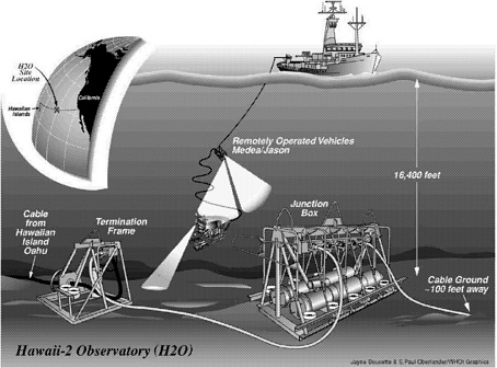
BOX 2-6 THE HAWAII-2 OBSERVATORY Objective: A permanent, deep-ocean, scientific research facility, the Hawaii-2 Observatory (H2O), was installed on the retired HAW-2 cable (Figure 2-4) in September 1998. The observatory consists of a seafloor submarine cable termination and junction box in 5,000 m of water locared halfway between Hawaii and California (Figure 2-5). The infrastructure was installed from a large research vessel using the remotely operated vehicle (ROV), Jason, and standard over-the-side gear. The junction box provides two-way digital communication at variable data rates of up to 115 kb/s using the RS-422 protocol and a total of 400 W of power for both junction box systems and user equipment. Instruments may be connected to the junction box at eight wet-mateable connectors using ROVs. The H2O junction box is a “smart” design that incorporates redundancy to protect against failure and with full control of instrument functionality from shore. Initial instrumentation at the observatory site includes broadband seismometer and hydrophone packages. Further information may be found at http://www.whoi.edu/science/GG/DSO/H2O/(H20, 2000). Location: Halfway between Hawaii and California (about 28° N, 143° W) in 5 km of water on a relatively featureless part of the seafloor between the Murray and Molokai fracture zones. Established: September 1998 |
|
BOX 2-7 THE HAWAI'I UNDERSEA GEO-OBSERVATORY Objective: The Hawai'i Undersea Geo-Observatory (HUGO) is an observatory installed on the summit of the Loihi seamount, the youngest volcano of the Hawaiian chain. This observatory was designed to provide electrical power, command capability, and real-time data transfer for experiments on Loihi. HUGO supplies up to 5 kW of power and nearly unlimited data bandwidth for experimenters using an electro-optical cable. HUGO experiments, supplied by the science community, are installed by submersible or ROV connection to the junction box and multiplexing nodes (Figure 2-6). Possible experiments include seismometers, hydrophones, and pressure sensors, as well as systems to monitor biological activity, chemical variations, hydrothermal venting, and motion of the unstable flank of Kilauea volcano (Plate IV). The observatory junction box is located at a depth of 1,200 m and has excellent acoustic visibility of approximately 1/4 of the world's oceans. Data can be viewed and heard at: http:// www.soest.hawaii.edu/HUGO/hugo.html (HUGO, 1998). Location: The Hawai'i Undersea Geo-Observatory junction box is located at a water depth of 1,200 m, approximately 30 mi southeast of the island of Hawai 'i. The system is operated by the University of Hawaii's School of Ocean & Earth Science & Technology. Established: HUGO was established in October 1997. The system operated until April 28, 1998, when an electrical fault in the cable shut it down. The system was again operated for a short period in October 1998, when a battery package was plugged into the junction box. Currently, operators are looking at options for replacing the cable and making improvements to the system. |
and magnified to initiate faults? (5) Why do “slow earthquakes” appear to occur only along seafloor transform faults?
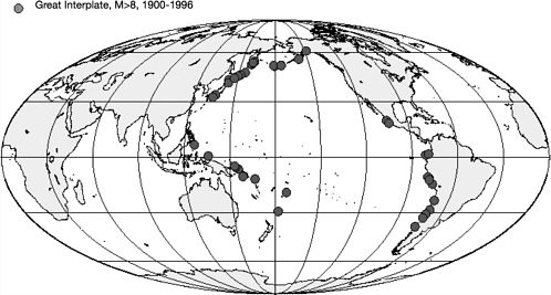
Subduction zone megathrusts produce the largest and potentially most destructive earthquakes and tsunamis on Earth (Figure 2-7). Despite the obvious societal impacts of these great earthquakes, little is known about the seismogenic zone that produces them. Understanding the origin of major earthquakes at subduction zones, such as those off the coasts of Japan, Central
America, and Cascadia, is the key focus of the international SEIsmogenic Zone Experiments (SEIZE) initiative. SEIZE experiments are aimed at determining the linkages between large-scale plate motions, strain accumulation, fault evolution, and fluid flow. The scientific strategy employed by SEIZE involves a combination of geophysical imaging, drilling, and long-term monitoring over an earthquake cycle (a few years to several decades) at a few representative subduction zones. The necessary long-term measurements include strain,
seismicity, and fluid flow at sites on and beneath the seafloor (in boreholes), as well as on land. These observations, in concert with laboratory experiments on the behavior of material in the seismogenic zone and theoretical modeling, offer the potential for major advances in our understanding of earthquake processes.
Major earthquakes are also common where continental crust is deforming, such as in the Basin and Range province in the western United States and along the San Andreas fault system in California. This area will be a major focus of a new program in the earth sciences community known as Earth Scope, and its subprograms the USArray and the Plate Boundary Observatory. A seafloor observatory program would complement these land-based studies by providing the capability to monitor deformation and faulting seaward of major active fault systems, like the San Andreas, in tectonic settings where fault systems may have less complex structures than on the continent.
Ridge-crest processes and oceanic volcanoes—Volcanism at mid-ocean ridges, in intraplate settings, and along convergent margins controls the flux of heat, mass, and volatiles from Earth's interior. The circulation of hydrothermal fluids transfers heat from the crust to the overlying ocean, extracts or deposits metal sulfides, and modifies ocean chemistry. As discussed in the section titled “Fluids and Life in the Oceanic Crust” earlier in this chapter, these same fluids support a variety of life-forms, from thermophilic bacteria in the sub-surface to macro-organisms on the seafloor around vents. Hydrothermal processes affect the chemical, thermal, and biological balance of oceanic environments, and also provide the best insights into primitive earth systems that harbored and conceivably initiated Earth's first life-forms. As a result of successful interdisciplinary programs, such as Ridge InterDisciplinary Global Experiments (RIDGE), and its international cousin, InterRIDGE, the importance of understanding the links among geological, physical, chemical, and biological processes at submarine volcanic systems is well established. However, the specific nature of these linkages and their variation in response to transient events, such as episodic dike intrusions and volcanic eruptions, is still poorly understood and will be a major focus of future studies.
Current ship-based studies allow only periodic visits (at intervals of months to years) to study volcanically active areas, and the deployment of low-(battery) powered, autonomous instruments offer the ability to make continuous measurements for periods of up to only a year or so. Response to remotely detected seismic and volcanic events must be mounted from shore, and can take weeks or months to reach the area of interest. Thus, critical hydrothermal and biogeochemical process that occur at and immediately after the time of an eruption have never been observed.
By installing long-term observatory nodes at 3 to 6 sites along the global mid-ocean ridge system and at a few oceanic volcanoes in other (off-axis)
settings, the linkages among these geological, physical, chemical, and biological processes and their response to transient volcanic and tectonic events can be studied. Observatory nodes in active volcanic and hydrothermal areas could provide the power, control, and data bandwidth for interactive arrays of geophysical, chemical, and biological sensors installed on the seafloor or in bore-holes. By supporting water-column observations from fixed moorings and from AUVs, the heat and chemical fluxes from chronic or episodic hydrothermal venting can be measured. The observatory node could also power remotely controlled seafloor rovers and AUVs to survey and sample more distant sites. In some cases, available power may permit in situ chemical and biological analyses, as well as the storage or freezing of critical samples for later recovery and shore-based analysis.
Oceanic plate kinematics, plate deformation, and faulting—Our picture of plate tectonics is based largely on historical datasets, such as the geomagnetic reversal record averaged over millions of years, geomorphologic estimates of transform-fault azimuths, and present-day earthquake slip vectors. These data have provided input to a plate tectonic model in which a dozen presumably rigid plates are each assigned a velocity vector. While successful overall, this model lacks detail because, essentially, all of our planet's plate boundaries are underwater. With a few notable exceptions (e.g., the San Andreas fault system), there are few constraints on contemporary crustal motions near plate boundaries.
A number of attempts are underway to begin monitoring motions along plate boundaries using various means, such as tilt, strain, and absolute gravity. All programs are aimed at sampling a single site and, in most cases, at widely spaced intervals in time. Seafloor observatories provide an opportunity to advance the embryonic science of monitoring geodetic motions on the seafloor. It will finally be possible to continuously observe motion near plate boundaries. The key questions seafloor geodetic observatories could address are as follows: (1) How do velocity vectors vary within an oceanic plate? (2) How variable is the deformation rate in the neo-volcanic zone extending from ridge axes down the flanks to the presumed rigid-plate edge? (3) Do spreading centers spread continuously or episodically? (4) In a subduction zone, where does the velocity change from continuous motion to a stick-slip regime? (5) How does deformation of the ocean basins affect mean sealevel? Seafloor geodetic studies will complement major new programs on the continents, including EarthScope and its subprograms USArray and the Plate Boundary Observatory.
Geological hazard mitigation—As the human population continues to grow, the potential social and economic dislocation from natural hazards, such as earthquakes, volcanoes, submarine landslides, and tsunamis, has increased. Major earthquakes in Japan, Taiwan, Turkey, and southern California over the past
decade have cost many thousands of lives and resulted in severe economic impacts (estimated at more than $1 trillion for the 1995 Kobe earthquake alone). Recent volcanic eruptions in Indonesia, Nicaragua, Papua New Guinea, and Ecuador have dislocated local populations, damaged infrastructure, and caused significant economic damage. These impacts are especially detrimental to developing nations, such as these, that are not easily able to rebuild infrastructure or mitigate economic effects.
As many of the most seismogenic areas, and some of the world's most active volcanoes, occur along the margins of continents, seafloor observatories will play a key role in global geohazard assessment and monitoring. Networks of hydroacoustic monitors, such as SOSUS, are needed to detect earthquakes, identify submarine volcanic eruptions, locate major submarine landslides, and provide early warning for tsunamis. Regional observatories, for example, those offshore of California and the Pacific Northwest, will be important because of the major earthquake risk in these areas. Relocatable observatories will be useful for detailed studies of active regions. In order to determine anomalous activity that may presage a seismic or volcanic event, decades of data should be collected continuously. A wide variety of sensors will be required to assess geological hazards, including seismometers; acoustic, tilt, and pressure sensors; and fluid monitoring and sampling devices.
TECHNICAL REQUIREMENTS
The diverse solid-earth applications for seafloor observatories result in a range of technical requirements that argue for a flexible observatory infrastructure using both cabled-based and moored-buoy systems.
The technical requirements for the global OSN sites are comparatively simple: a broadband seismometer with a sensor mounted in a borehole or buried in sediment, and a seafloor magnetometer. Power requirements (<10 W on the seafloor) and data telemetry needs (a few 10s of Mb/day) are modest. Continuous real-time data telemetry will be useful, although dial-up capabilities to retrieve data from specific time intervals of interest would be sufficient in many cases, reducing telemetry needs to a few Mb/day or less. OSN sites will offer many opportunities for ancillary measurements for oceanographic (Plate II), geochemical, and geodetic studies that in some cases (e.g., acoustic thermometry) could significantly increase the power and telemetry requirements. Because of the remote locations proposed for OSN sites (typically 1,500-2,000 km from land), moored-buoy installations are likely to be the favored approach in most cases, but in some instances cabled installations may be possible (e.g., H2O [Box 2-6]). It is expected that the OSN sites will need to be serviced at least annually. Given their remote locations (many are in the Southern Ocean), servicing of these stations will be logistically challenging and costly.
A seafloor geodetic experiment would require 3 to 4 battery-operated transponders, a three-antenna global positioning system (GPS), an acoustic transmitter, and a sonar processor on the buoy (Figure 2-8). Power requirements for the GPS systems would be approximately 10 to 20 W and the acoustic system would likely operate continuously for 48 hours every 1 to 2 weeks. Other geodetic sensors, such as seafloor strainmeters, tiltmeters, and absolute gravimeters are under development, and would be essential components of a seafloor geodetic experiment.
Observatories on ridge crests, at subduction-zone megathrusts, and on mid-plate volcanoes will need to be designed to support a wide range of sensor types. The resulting power and bandwidth requirements could be substantial. For many physical processes of interest, sensors already exist. However, development of chemical and biological sensors is needed to characterize hydrothermal fluids and measure in situ variations in biomass, metabolic activity, and species composition. For certain applications, photography and real-time video will be required. In addition, remotely controlled seafloor rovers and AUVs will be needed to collect data and samples in a broader area around each
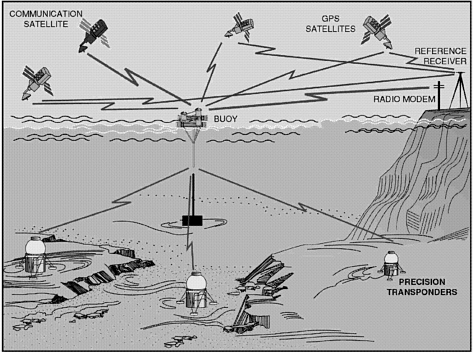
FIGURE 2-8 Schematic drawing of a seafloor geodetic experiment showing the buoy, seafloor transponders, global positioning system, and acoustic transmitter. SOURCE: John Orcutt, Scripps Institution of Oceanography.
node. The ability to drill boreholes for the installation of sub-seafloor instruments will also be an essential requirement.
The power and telemetry needs for ridge-crest, subduction-zone megathrust, and mid-plate volcano observatories will be relatively high (100s of W to several kW of power at each node; 100s of Mb/day to Gb/day of telemetry bandwidth). These requirements will favor cabled observatories for many sites but, for remote locations (e.g., East Pacific Rise or parts of the Mid-Atlantic Ridge), large moored-buoy systems may be more cost-effective. A relocatable and rapidly deployable moored-buoy observatory system will also be needed to study transient natural events (volcanic eruptions, earthquake swarms) and to conduct in situ perturbation experiments. These systems will have comparatively modest power and bandwidth requirements.
COASTAL OCEAN PROCESSES
The coastal ocean includes estuaries, the surf zone, the Laurentian Great Lakes, the continental shelf, and the continental slope. This definition incorporates a great deal of environmental diversity. For example, estuaries have distinctly different environmental characteristics in terms of depth, processes, and accessibility as compared to the continental slope. Furthermore, coastal regions are distinct from the deeper, open ocean for a number of reasons: (1) the coastal ocean is where terrestrial influences encounter the broader ocean; (2) the coastal zone is the area of the ocean most strongly affected by anthropogenic impacts; (3) the coastal ocean displays a strong geographic diversity, depending on forcing agents and topographical setting; (4) the coastal ocean, being generally shallow, tends to be strongly influenced by energy and material fluxes through the surface and bottom; (5) the coastal zone is the most biologically productive part of the ocean and hence is the most heavily fished; (6) physical, chemical, geological, and biological patterns in the coastal ocean tend to be anisotropic,2 intermittent (both in space and time), and rapidly changing relative to the deeper ocean. These factors make the coastal ocean a challenging environment for scientific study.
FUTURE DIRECTIONS AND MAJOR SCIENTIFIC PROBLEMS
Perceptions of what are the important scientific problems in coastal oceanography are possibly as diverse as the number of investigators. Discussions at the symposium showed, however, that common themes exist and, despite the diversity of goals, there is a striking commonality in terms of the sorts of long-term measurements that might be valuable. Some major problems in coastal ocean science are listed below.
|
2 |
Anisotropy - having properties that differ according to the direction of measurement. |
|
BOX 2-8 OBSERVATORY SCENARIO: DETECTION, OBSERVATION, AND RESPONSE TO AN ALGAL BLOOM Algal blooms are episodic, not presently predictable, and difficult to study using traditional expeditionary approaches. Blooms of some species have serious impacts on marine ecosystems and human health, and are the focus of general environmental concern (http://www.redtide.whoi.edu/hab/nationplan/nationplan.html [EcoHAB, 1994]). Large algal blooms that occur offshore provide a pulse of organic matter to deep environments, affecting population dynamics and seasonality in bottom-dwelling organisms. A seafloor observatory positioned in a location where blooms occur could contribute substantially to our understanding of processes initiating algal blooms, and the effect of these blooms on marine communities and food webs. Such an observatory might include an array of nodes with sensors measuring physical, chemical, and biological characteristics at the surface, throughout the water column, and on the seafloor. These measurements would likely include temperature, salinity, nutrients, water clarity, and fluorescence. Once a bloom is detected, sensors would increase data collection and communication rates; an AUV would be sent out to survey water-column and seafloor effects; and drifters would be released to track the horizontal advection and dispersion of the bloom. In the near term, a ship might be deployed to take measurements and samples in the bloom-affected water mass; in subsequent years, drifter technology may improve so that all measurements are made by sensors on the drifters. If the bloom is deemed toxic, monitoring of shellfish, fish, and marine mammals would be initiated and pertinent information would be transferred to resource managers and the public. |
-
Coastal ecosystems are extremely productive, but not very well understood in terms of how their structures and functions respond to variations in environmental conditions. For example, we need to learn more about the causes and predictability of harmful algal blooms (Box 2-8). Part of this learning process would require the collection of long time-series datasets of physical, nutrient, and algal conditions in the coastal ocean that could then be used to enhance our level of understanding, as well as be used for actual day-to-day prediction.
-
Global change is of general interest to society. In the coastal ocean, there are concerns both about how such change might affect littoral areas (e.g., how a change of wind patterns affect might coastal productivity), and about how the resulting variations within the coastal zone might affect the rest of the ocean through such processes as water mass formation at high latitudes and coastal influences on global biogeochemical cycles. Separating natural changes from anthropogenic change is essential.
-
A number of coastal management issues will require long, high-resolution time series of coastal ocean processes. Fisheries applications are an obvious example, but there are numerous other concerns, such as coastal eutrophication, impacts of transportation, and the effects of nearshore minerals exploitation.
A common thread in all these concerns is the need to quantify and model the fluxes of water, materials, and energy through boundaries in the coastal environment, be they lateral (such as river inflows or transport of oceanic waters onshore) or vertical (through the sea surface or the bottom).
THE ROLE AND DESIGN OF SUSTAINED TIME-SERIES OBSERVATIONS
Oceanographic understanding often results from diagnosing how changes in a natural system occur; a more static approach of simply mapping out the present state of a feature tends to be less productive. The need to understand oceanographic change then implies a need to document environmental changes and their potential forcing agents. Because modes of oceanographic variability can change with time over weeks to years, there is a great need to collect long time series in order to document important variations in critical parameters.
Sampling considerations dictate some stringent experimental requirements. If a strongly nonlinear process, such as sediment transport, is of interest, then episodic (rare but highly energetic) events can be expected to dominate the records. These events, such as the passage of a hurricane, will be short-lived and are likely to be unpredictable over the timescales needed to emplace oceanographic measurements. Thus, to observe the impacts of episodic events, well-sampled, long-term observations are needed (Table 2-4). On the other hand, many ongoing coastal ocean processes tend to be dominated by shorter timescale variability, such as tides or wind events. Thus, to investigate this short timescale variability, sampling on hourly versus longer timescales will be needed, as opposed to the weekly timescales that may be meaningful for open ocean processes.
TABLE 2-4 Coastal Ocean Processes: Areas Where Observatories Are Very Useful to Investigate a Particular Scientific Problem and Where They Are Useful
|
Observatory science is VERY USEFUL to investigate the following:
Observatory science is USEFUL to investigate the following:
To address the science where observatories are essential, development or improvement of the following sensors is needed:
|
The coastal ocean is often typified by relatively short spatial scales and by strong anisotropy. For example, alongshore currents over the shelf tend to be typified by cross-shelf scales of 10 kms in magnitude, but can have considerably greater alongshore scales. Short spatial scales mean that a single-point measurement may only represent a very small volume of the ocean. Thus, there is a clear need to make sufficient spatial measurements to fully characterize the environment of interest. It is useful to envision a sustained three-dimensional network of measurements that will be able to describe, in detail, a given area and that will allow evaluation of advective transports.
The coastal ocean incorporates a variety of environments. For example, the shelf off the coast of Maine is distinctly different than that off Georgia, and estuarine environments are distinctly different than those of the continental shelf. It appears that the most useful approach to investigate the coastal zone using long time-series measurements is to pick a few representative settings, measure them in detail for a long enough time to gain confidence in having resolved the important variability (10 years would be a credible guess, but this would have to be evaluated as the dataset evolves), and then move the observing capability to another location.
One design for making long-term measurements in the coastal ocean would be to deploy arrays of moorings equipped to measure sediment properties and parameters, such as winds, waves, currents, temperature, salinity, nutrients, optical variables, acoustics, and bottom stress. This list would only
represent a starting point, as other measurements might be required for specific scientific needs. The moored array could be L-shaped so as to resolve cross-shelf and alongshore variations. A low-cost model for a moored-buoy observatory has been proposed by Frye et al. (1999). This observatory is portable, easy to deploy and configure, and capable of supporting a variety of instruments, yet it has limited data-transmission capabilities and all instruments must share the same acoustics channel. Another eventual approach would be to deploy a single, well-equipped mooring that is also home to an AUV that can make frequent, rapid surveys of the surrounding region.
Regardless of the design of the measurement network, attention be paid to coordination with remotely sensed (either from space or shore) measurements and other existing long-term measurements, such as those from tide gauges. Furthermore, real-time communications will be necessary for adaptive sampling within events, and for predictive modeling for coastal management. Improved (or new) sensors are needed for turbulence, dissolved oxygen, plankton, nutrients, and DNA.
TURBULENT MIXING AND BIOPHYSICAL INTERACTION
Turbulent mixing occurs over a broad spectrum of timescales and space scales, strongly affecting the distribution of momentum, heat, chemical compounds, and living organisms in the ocean. Modeling of the physics of turbulent flows is a major limitation in our ability to simulate observed ocean circulation features. Turbulence has widely acknowledged but little studied effects on a range of biological processes, including cycles of surface primary productivity, encounter rates between male and female gametes or predator and prey, aggregation and dispersion of plankton at fronts, and settlement of larvae into the benthos. Turbulent mixing at the sea surface mediates air-sea exchange of biologically reactive compounds, such as dimethyl sulfide and carbon dioxide. Turbulence in the bottom boundary layer plays a role in bentho-pelagic coupling of nutrients, and affects fertilization kinetics, chemical signaling, transport, habitat choice, and generic exchange in benthic communities. Mesoscale eddies and fronts are now recognized as contributing to patchiness in plankton communities that has long puzzled biologists.
FUTURE DIRECTIONS AND MAJOR SCIENTIFIC PROBLEMS
The general character of turbulent motions is that they are intermittent and random, and thus not predictable in detail. However, prediction of turbulence statistics and its integral impacts on property distributions is possible. Present ocean circulation models very crudely parameterize mixing, with regional and global results being rather sensitive to particular parameterization
schemes. Horizontal and vertical turbulent fluxes are treated separately because of the distinctly different importance of vertical stratification and Earth's rotation, and because of the very different turbulence generation mechanisms involved. Because the actual character of turbulent motions in the ocean depends considerably on geographically and temporally variable flow regimes, better parameterizations of the impact of turbulence on oceanic properties are sought first for distinct physical regimes. The grand objective, however, is a parameterization of turbulence statistics as a function of larger-scale, more deterministic flows that can be applied broadly.
The physical oceanography community has identified subregions of general circulation models that are greatly in need of improvement, including deep convection, boundary currents and benthic boundary layers, the dynamics and thermohaline variability of the upper mixed layer, fluxes across the air-sea interface, diapycnal mixing, and topographic effects. Progress in all of these areas is likely as our capacity for modeling smaller scale features increases, and as physical parameterizations are developed (Royer and Young, 1999).
“Vertical” (Diapycnal) Turbulent Fluxes
Major advances in understanding diapycnal turbulent fluxes in the ocean interior have been made recently, and the physical oceanography community is looking forward to a quantum leap in understanding. In The Future of Physical Oceanography, this is concisely expressed:
Past achievements in quantifying small-scale turbulent mixing in the main thermocline, coupled with exciting recent measurements in the deep ocean, suggest that a description and an understanding of the spatial distribution of turbulent mixing in the global ocean is achievable in the next decade. Unraveling the possible connections between the spatial and temporal distribution of mixing, the large-scale meridional overturning circulation, and climate variability are important aspects of this research. (Royer and Young, 1999)
There is a strong connection between the understanding of coastal ocean processes (see “Coastal Ocean Processes” section earlier in this chapter) and diapycnal mixing:
Substantial advances have been made in understanding and predicting the peculiar properties of turbulent and rapidly rotating boundary layers over a sloping bottom. Because of the bottom slopes, flow across depth contours implies a vertical density transport which can determine the character, or even existence, of transport in the boundary layer. Flow near the bottom is important because of its role in transporting materials (such as sediments and benthic biota) between shallow and deep water.
These bottom flows also govern the behavior of stronger alongshore flows in the overlying water column. Thus, an appreciation of the linkage between the bottom boundary layer and the interior, is essential to an understanding of the dynamics of alongshore flows on the continental shelf. (Royer and Young, 1999)
Horizontal Turbulent Fluxes
As with diapycnal turbulent fluxes, there is a clear sense that a quantum improvement in our understanding of horizontal turbulence is within reach:
Knowledge of the horizontal structure of the ocean on scales between the mesoscale (roughly 50 km) and the microscale (roughly less than 10 m) will be radically advanced and altered. The growing use of towed and autonomous vehicles, in combination with acoustic Doppler current profilers, will revolutionize our view of the ocean by exploring and mapping these almost unvisited scales throughout the global ocean. While this research is driven by interdisciplinary forces (biological processes and variability are active on these relatively small horizontal scales) it is also a new frontier for physical oceanography, and one in which even present technology enables ocean observers to obtain impressive datasets. (Royer and Young, 1999)
THE ROLE OF SUSTAINED TIME-SERIES OBSERVATIONS
The main challenge for the parameterization of turbulent mixing is in obtaining high-quality turbulence statistics and their variation, along with sufficiently dense temporal and spatial information about the oceanic processes that modulate the turbulence. To develop a universal parameterization it is necessary to conduct observational studies in a broad range of environmental conditions (Table 2-5). At present, research cruises of approximately one month's duration are made to a particular region where intensive micro-structure profiling is conducted. A vertical profile of turbulence parameters is obtained, along with some sense of its temporal or regional variation. It is usually impossible to separate these variations. In addition, there is often insufficient information concerning the large-scale motions that cause these variations. Because there are relatively few groups that have the technical capability to measure turbulence parameters, the progress of the mixing community has been slow relative to the critical importance of improving numerical models.
While sufficiently long time series are necessary to obtain stable statistical properties of oceanic turbulence, even longer time series are required to observe modulations of these statistics by variations in the large-scale flow environment. However, without the context provided primarily by spatial flux divergences associated with wave propagation and advection, improved mixing
TABLE 2-5 Turbulent Mixing and Biophysical Interaction: Areas Where Observatories Are Very Useful to Investigate a Particular Scientific Problem
|
Observatory science is VERY USEFUL to accomplish the following:
|
parameterization will be elusive. Because turbulence depends strongly on stratification, vertical resolution of turbulence parameters has the highest priority. Fine sampling in the horizontal will be more valuable than fine temporal sampling for resolving mixing issues.
Repeated, high, vertical-resolution sampling with a coarse, horizontal array of moored conductivity, temperature, and depth (CTD) and velocity profilers is now possible, and such an array can be used to examine mixing issues independent of a seafloor observatory program. To add value to these arrays, the seafloor observatory concept must provide the needed horizontal resolution over much finer scales than presently possible. This increased resolution would provide fully four-dimensional sampling and could be obtained with AUVs. Near real-time telemetry and an active modeling and analysis component could be employed to optimize the sampling strategy. Other methods of obtaining high-resolution spatial information should also be explored, such as horizontal mooring lines and acoustic Doppler technology.
The strategy outlined above could go far in terms of closing budgets or constraining numerical models. (Closure of heat, salt, momentum, and tracer budgets is important because it demonstrates sufficient observational accuracy and adequate resolution of advection and mixing.) A sequence of field programs in different dynamical regimes would provide us with a decadal leap in the understanding of mixing processes by covering the oceanic turbulence parameter space. A seafloor observatory program would be of great benefit to advancing our understanding and parameterization of mixing if it were to enable such a dedicated set of oceanic observations. Suggested dynamical regimes, which should not be considered exhaustive, are discussed in Box 2-9 below.
A similar problem exists for observing and parameterizing the effects of horizontal turbulent motions, in particular for mesoscale eddies, although the technical challenge of observing those scales of turbulence is not nearly so high as for the very small scales of vertical mixing.
|
BOX 2-9 SURVEYING TURBULENCE REGIMES IN PURSUIT OF UNIVERSAL PARAMETERIZATION Some of the dynamic regimes that need to be observed to develop more universal turbulence parameterizations include the following:
|
|
There are important potential synergies that could be achieved by collocating biological and physical studies. These were not addressed by the workshop, but are alluded to in both the Report of the APROPOS Workshop (Royer and Young, 1999) and Report of the OEUVRE Workshop (Jumars and Hay, 1999). The idea of “imaging” a volume of the ocean to quantify circulation, mixing, biology, and chemistry within a high-resolution cabled observatory has been suggested. The connection of biomass “patchiness” to eddies is an important topic to be pursued.
The turbulent mixing discussion at the workshop concluded that an observational and modeling strategy that uses the seafloor observatory infrastructure could significantly advance our understanding of turbulent mixing processes and our ability to parameterize them in ocean models. This, in turn, would have an important impact on biogeochemical models. The observatory concept is of limited value to the turbulent mixing community without the ability to implement the strategy of acquiring data in four dimensions while executing dedicated process studies.
TECHNICAL REQUIREMENTS
Platforms for turbulence measurements must be designed to minimize flow distortion and impacts on turbulence structures. Relocatable observatories will be needed to support process studies to survey turbulence parameter space, and to study the influences of turbulent motions on biological processes. To accomplish the required observations within a decade, three observatories must be dedicated to this task, with a deployment of 2 to 3 years in duration at
each location. This number of observatories allows for refurbishment and sequential deployments. Each observatory would consist of a coupled array of moorings and a number of AUVs. The moored array would consist of 3 to 5 (subsurface) moored profilers measuring velocity, pressure, temperature, salinity, fluorescence, light transmission, and irradiance; and a surface mooring measuring atmospheric forcing, near-surface currents, and other variables. The mooring could also employ a bottom tripod system, such as the Benthic Acoustic Stress Sensor. The AUVs should measure velocity, conductivity, temperature, depth, and turbulence parameters.
Cabled observatories would be most appropriate for long-term intensive volumetric interdisciplinary studies with evolving capabilities, such as for investigating the interaction of biological processes with mesoscale eddies.
There is a need for turbulence sensors that are compatible with long unattended deployment periods on moorings and AUVs. New sensors must be developed for nutrients (macro and micro) and other chemicals. Sensor development is also required for automated plankton, nekton, and benthic species identification and enumeration by , physiological state, and other traits of interest. The stability and calibration of all sensors requiring long-term deployment is an important consideration that needs to be addressed. Furthermore, the capability of tracking natural tracers (e.g., atmospheric inputs, seafloor vent effluent) and for releasing and tracking purposeful tracers (SF6; glass microballs for acoustic tracking) is important for quantifying the integral impacts of mixing.
Technical requirements in common with the ocean climate objectives are given in the section titled “Role of the Ocean in Climate” earlier in this chapter.
ECOSYSTEM DYNAMICS AND BIODIVERSITY
Seafloor observatories are crucial for addressing many of the major scientific problems identified by the NSF Futures report on biological oceanography, Report of the OEUVRE Workshop (Jumars and Hay, 1999; Table 2-6). Specific questions benefiting most from the sustained time-series observations are those regarding time-dependent processes and episodically triggered events, and those requiring long-term datasets. These questions fall under broad integrative categories that range from oceanic biology and ecology to biogeochemistry. Other equally valid questions are not well served by the observatory approach, such as those concerned with details of specific biochemical, cellular, or physiological mechanisms occurring within organisms, or behaviors and environmental interactions occurring on the scale of individual organisms. It is also important to note that the observatory approach, while necessary for solving many problems in marine ecology and biological oceanography, is not sufficient alone, and must be used in concert with other approaches (e.g., controlled experimentation, modeling, analysis of the fossil record).
TABLE 2-6 Ecosystem Dynamics and Biodiversity: Areas Where Observatories Are Very Useful to Investigate a Particular Scientific Problem and Where They Are Useful.
|
Observatory science is VERY USEFUL to accomplish the following:
Observatory science is USEFUL to accomplish the following:
To address the science where observatories are very useful, development or improvement of the following sensors is needed:
|
Oceanic ecological observatories will extend into deep water the concept of the U.S. Long-Term Ecological Research Network (LTER), which now includes only a few ocean- and land-margin sites. The mission of the LTER is similar to that proposed for seafloor observatories in that it aims to understand ecological phenomena occurring over long temporal and broad spatial scales and to increase the understanding of major natural and anthropogenic environmental perturbations at selected sites. Just as restricting a seismometer network only to land limits the ability of geophysicists to understand the dynamics of the earth, restricting ecological observatories only to land limits the ability of ecologists to fully understand the dynamics of the biosphere (Box 2-10).
For this discussion, a seafloor observatory is considered in the broadest sense as a system supporting measurements from the seafloor to the ocean surface, including a nested arrangement of instrumentation covering spatial scales of meters to hundreds of kilometers. An observatory might consist of a series of stationary observatory nodes to monitor the seafloor and water column and autonomous underwater vehicles dispatched to provide broader spatial and temporal coverage. This definition does not include Lagrangian drifters or floats per se, but their use will greatly complement an array of fixed observatory sites. In some cases, observatories will be most effective when used with more traditional approaches, such as drifters, ROVs, manned submersibles, and surface ships.
The following are scientific questions well suited for study using seafloor observatories along with a description of the most compatible facility to address the particular scientific problem.
-
How do environmental and biotic factors determine the distributions and activities of key species or communities important to biogeochemical cycles in both space and time?
This question refers to a classical community ecology approach (explaining the distribution and abundance of species) to help understand a systems ecology problem (cycling of mass and energy). An associated question asks what the important interactions are among marine biota, global climate, and biogeochemistry. Important scientific problems related to this general question include responses of coastal margin systems to nutrient loading; biogeochemical implications of daily, seasonal, and life-cycle migrations of populations; food-web analysis; and influences of climate change on nutrients, trace metals, and trace gases. Research under this broad question might deal with the controls on harmful algal blooms, population dynamics of predators, deep-community responses to episodic nutrient pulses, or exploitation of fisheries and other resources.
|
BOX 2-10 LONG-TERM ECOSYSTEM UNDERWATER OBSERVATORY Objective: The Long-Term Ecosystem Underwater Observatory, 15 m below the surface (LEO-15), provides three subsea nodes for connection of instruments (Figure 2-9). The system provides both power and communications for these instruments via a cable between the subsea nodes at the LEO-15 situ and shore facilities at Rutgers University. Each of the identical nodes provides eight standard interfaces for guest instruments as well as a variety of specialized interfaces for other instruments. Continual measurements made at each node include water temperature, salinity, clarity, wave height, wave period, chlorophyll content, and current speed and direction. An electric/fiber-optic cable that connects to the two permanent subsea nodes at LEO-15 is designed to provide power and two-way, real-time, high-bandwidth communications (including video) to instruments, remote platforms, ROVs, and AUVs. The data received from LEO-15 instruments are used to model and predict currents and summertime upwelling and to aid biologists in the research of benthic communities and phytoplankton ecology. Location: Immediately offshore of Great Bay near Tuckerton, New Jersey; 15 m of water Established: August 1996 |
Long-term, cabled observatories are essential for examining important time-dependent aspects of the question above. This is especially true for those experiments needing instruments with large power requirements. Relocatable observatories will also be a useful approach when addressing ecological questions where shorter-term time series are sufficient (as with the study of hydrothermal vent communities). Global observatory coverage is not
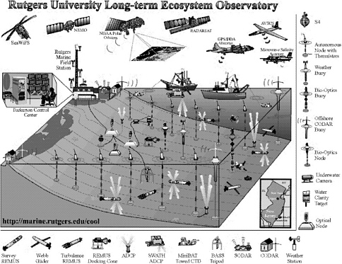
necessary for these scientific questions, although a subset of the locations proposed for global climate and geodynamics studies may coincide with sites for these ecological studies.
For certain applications, the sampling interval of data collection may be less than hourly, but data transfer would be required less frequently (e.g., daily or weekly). The main exception to this telemetry requirement would be
for applications that include detection and response to episodic events. For these projects, ‘smart' instruments should be installed with a capability for quick transmission of data at the onset of an event. As soon as an event or event-precursors are detected, sensors would begin sampling more frequently, two-way communications would be initiated, and associated sample collection or Lagrangian activities (drifters, surface ship) would be mobilized.
Instruments required for this scientific question include stationary sensors recording a variety of physical, chemical, and biological parameters (the latter would include coulter counters, video plankton recorders, etc.); cameras (film, digital, or video); active tracking sonars and other acoustic instrumentation; and AUVs equipped with biosensors and optics. Cameras would most likely be operated in a time-lapse mode, with the exception of those coupled to public and education outreach projects. These would be operated continuously and require real-time data telemetry. Data collected from the sensors listed above should be correlated with satellite data providing optical information and radar imaging for current flow.
It is anticipated that perturbation experiments, such as the controlled release of chemicals or tracers into the water column, or manipulations of seafloor communities using colonization surfaces, faunal clearances, faunal transplants, and predator inclusion and exclusions, will be conducted as part of the observatory activities, and that ecosystem responses will be recorded with sensors and by sampling. Although many studies will continue to require retrieval of water, microbes, plankton, and benthic organisms, this need will decrease as new in situ optical, acoustic, and genetic instruments for detecting and identifying organisms are developed. Samples that are collected could potentially be analyzed in situ using instruments adapted from those used in the laboratory (e.g., spectrophotometers, mass-spectrometers, coulter counters, CHN analyzers, gene chips3), or these samples could be preserved using chemical (injection of ethanol, formalin, etc.) or thermal (freezing) means. Alternatively, sampling could be conducted periodically by ROVs during scheduled observatory maintenance visits.
-
What are the functional dynamics of populations and communities?
Specific research topics related to this question deal with the spread of pathogens, the causes and consequences of synchronous spawning, and fertilization success. A longer-term aspect of the question above concerns quantifying the spatial scales over which marine populations are connected via dispersal
|
3 |
Gene chips - This technology promises to monitor the whole genome on a single chip so that researchers can have a better picture of the interactions among thousands of genes simultaneously. |
of early life stages. Specifically, research in this area would investigate the influence of local population isolation and barriers to dispersal, and also linkages in the epidemiology of disease. Time-series observations are essential for addressing some aspects of these questions, but they are not sufficient to answer the questions comprehensively. Thus, observatory activities would need to be coordinated with more traditional ship- or submersible-based approaches.
The research questions outlined above would require time-series measurements over a period of one to five years using a flexible (relocatable) observatory system located at strategic, problem-specific locations. Data would be collected at hourly or longer intervals, with the exception of periods following occurrences, such as spawning events, when frequencies of seconds to minutes would be useful to assess such issues as gamete mixing, fertilization success, and propagule dispersion. Data transmission requirements would be modest (on daily or longer frequencies) except during and immediately after events. For fertilization studies, only a few closely spaced nodes would be required, but for studies on the spread of pathogens numerous (on the order of 10) nodes spaced over 10s to 100s of km would be required. Necessary sensors and instruments would include physical, chemical, optical, and biological sensors, such as gene chips, time-sequencing settling plates, and traps. Perturbation experiments would be beneficial to these studies (e.g., induction of spawning through chemical or mechanical shock and controlled release of a non-reactive pathogen mimic), and sampling of organisms for in situ or laboratory analysis (as described above) may be necessary for some projects.
-
What are the dynamics of marine food webs, and how will they respond to environmental perturbations?
Specific scientific problems include encounter rates of predators and prey, long-term variations in population abundances, and detection of processes generating large-scale patterns in ecosystems. Both long-term and relocatable observatories are essential to address this question. Data recording and telemetry frequencies, locations and numbers of nodes and sensors, and methodologies are similar to those described for questions 1 and 2 above.
-
How can population and community changes, such as fluctuations in fisheries stocks and food web dynamics, be accurately forecast? Furthermore, is it possible to evaluate the multiple-scale and pervasive human impacts on the sea, given the confounding effects of weather and climate change?
To address these questions it is necessary to have long-term observations, particularly in relatively unimpacted environments where ecological baselines
can be established. It is also important to collect time-series measurements that will illuminate the relationships between environmental forcing and changes in ecosystems over very long timescales. These scientific problems will benefit greatly from coordination within a multidisciplinary approach, including long time-series circulation and climate studies. Cabled observatories would be required for forecasting regional changes, while the coordinated use of data from many widely spaced cabled or moored buoy observatories would be needed to study large-scale physical-chemical-biological interactions.
Long-term studies are likely to require a cabled network with a series of moorings with cameras, active omnidirectional acoustic sonars, and environmental sensors measuring physical, chemical, and biological properties. Because identification, genetic, and chemical analyses of organisms will be a component of the studies, procedures for in situ sample processing and sample collection will be needed. Perturbative and event-response approaches will be less important for these studies, but of possible use in specific projects.


