
1
Introduction
The purpose of this report is to evaluate the National Water-Use Information Program (NWUIP) of the U.S. Geological Survey (USGS). The NWUIP is the main source of information about water use in the nation. This information is used by Congress, governmental agencies, and increasingly by research scientists to evaluate water used by the nation and alterations in water use that are related to demographic, economic, climatic, and other changes. The summary of national water use produced by the NWUIP every five years is the principal source from which spatial and temporal trends of water use in the United States are derived.
The evaluation process used by the committee included information gathering, program assessment, and the preparation of conclusions and recommendations. Information about the water use program was obtained from the NWUIP Web site (http://water.usgs.gov/watuse), from USGS and other publications, from other (unpublished) documents, from formal presentations by USGS staff, from analyses of NWUIP data, from discussions with water use specialists in various USGS districts, and from discussions with agency specialists in other USGS resource evaluation programs. The program evaluation was conducted in context with a statement of task that was jointly agreed upon by the USGS and National Research Council (NRC) staff. This statement of task is provided below.
STATEMENT OF TASK: REVIEW OF THE NATIONAL WATER-USE INFORMATION PROGRAM
“The study will provide guidance to the USGS on development of an improved National Water-Use Information Program. Beginning with an assessment of the existing USGS water-use information program, the study will consider
how the program could be optimized within existing resources, considering analysis methods, data quality and presentation of results. The study will also consider if additional resources should become available, what would be the priorities for investing those resources to improve the program.
“Some specific questions to be addressed by the study include the following:
-
Are there better ways to estimate water use (e.g. surveys or other statistical approaches)?
-
How might the best approach vary by category of water use?
-
What are the relative merits of the various water-use categories?
-
What is the value of information at different spatial scales – state, basin, county, aquifers, and hydrologic unit?
-
What is the value of information at different time scales and how can data be normalized for climatic variability?
-
What should be the relationship of other agencies and institutions (universities; federal, State and local agencies; etc) to this program?
-
What are the priorities for interpretive products from the program?
-
What research could the USGS carry out that would lead to an improved water-use science.”
CONCEPTUAL FRAMEWORK
Throughout its deliberations, the committee noticed that the USGS has not defined a conceptual framework for water use that places water use data and the NWUIP in context with the other water resources programs of the USGS. From a scientific perspective, this conceptual framework is an important link between water use and its impact on water resources. The principal product of the NWUIP has been its five-year national estimates of aggregated water use, compiled primarily by counties and states. Underlying these aggregated estimates, however, are more detailed site-specific data about water use, in which each individual water withdrawal locations are tabulated, the types of water use determined, and the amounts of water use estimated. At this site-specific level of water use, the source of surface water or groundwater for each water use site is identified, and the link between water use and water resources is established. The committee has been impressed by the increasing availability of national geospatial information on water resources, attributable to efforts of the USGS and other federal agencies to convert tabular data inventories describing water facilities into mapped locations with attached attributes. This activity makes possible “place-based” or “location-based” analysis in which georeferenced data from disparate sources are synthesized into an integrated database that can support more comprehensive study than can the separate data sources taken alone.
All these considerations have led to a conceptual framework for the NWUIP, as shown in Figure 1.1. The USGS is the primary agency that measures the
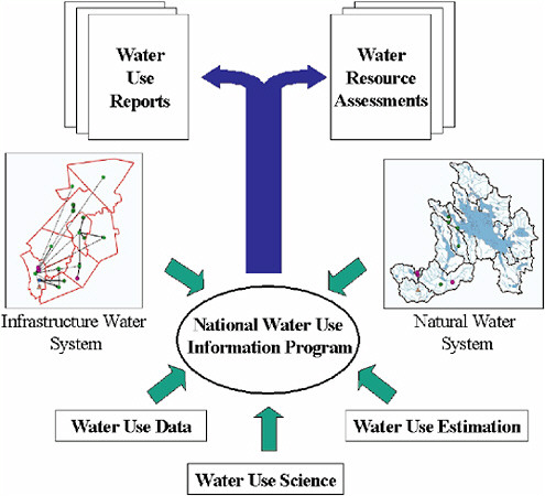
FIGURE 1.1 Conceptual framework for the National Water-Use Information Program.
quantity and quality of water in the natural water system of streams, rivers, lakes, aquifers, and watersheds. The natural water system coexists with the infrastructure water system, described by locations of water withdrawals and discharges, and by the principal water facilities (pumping stations, treatment plants, water conveyance systems) through which water is moved through the landscape in constructed water systems. Exchanges of water occur between natural water systems and infrastructure water systems, primarily at the points of water withdrawal and discharge. The principal focus of the NWUIP is the quantification of the infrastructure water system. The vignettes of the infrastructure and natural water systems shown in Figure 1.1 are drawn from a region in central New Hampshire using data from the New England Water-Use Database System, described in more detail in Chapter 7 of this report.
In this framework, the NWUIP is supported by water use data, water use estimation, and water use science. Water use data comprise the locations and characteristics of water withdrawals, discharges, and facilities and the amounts of water used at those locations. Water use estimation encompasses statistical sampling, regression, and other estimating methods such as coefficient models for determining the total water use within a given geographic region (often a site, city, or county) or from a particular water resource (e.g., a river or aquifer). Integrative water use science is founded on data and estimation, since these are the principal elements of observation of water use; however, it also includes integrating water use with water quality, and it includes environmental issues in water systems. The products of this conceptual framework are (1) water use reports, such as the five-year national water use summaries, and interpretive water use data reports prepared at the state and regional level and (2) water resource assessments in which the relationship between water use and availability of water is examined for particular aquifers or watersheds, or the impact of water use on water quality and environmental conditions is studied for particular regions.
DEFINITIONS OF “WATER USE” AND RELATED CONCEPTS
In this section, we briefly define terms that are commonly used in the USGS water use summary reports. The term water use refers to all instream and offstream uses of water for human purposes from any water source.
In the water use context, some terms acquire slightly different meanings than they have in the context water resources research. For example, in the water use context “instream” and “offstream” can both apply to either surface water or groundwater sources. The definitions below are from Solley et al. (1998), which includes an extensive water use glossary.
Offstream use refers to water that is diverted from surface water sources or withdrawn from groundwater sources (i.e., a “withdrawal”) and is conveyed to the place of use. Most offstream or withdrawal uses that are compiled in USGS reports are self-supplied data from public suppliers, agencies, etc. Water use data are estimated for other categories, including domestic, commercial, irrigation, livestock, industrial, mining, and thermoelectric power.
Instream use refers to water use that takes place without water being withdrawn from surface water or groundwater. Instream uses include hydroelectric power generation, navigation, maintenance of minimum streamflows to support fish and wildlife, and minimum streamflows for wastewater assimilation. Hydroelectric power generation is the only instream use that is currently being evaluated on a national scale. California currently quantifies various types of instream uses.
Water that is diverted or withdrawn from surface or groundwater sources (offstream use) either is lost to the system (consumed) or returned to surface or groundwater bodies. These distinctions are made as follows:
Consumptive use refers to the portion of withdrawn water that is evaporated, transpired, or incorporated into products, animals, or crops. In some cases, consumptive use is evaluated as the difference between the volume of water delivered and the amount returned to water sources.
Conveyance loss is the amount of water that is lost in transit, either between the source and the point of use or from the point of use to the point of return. This is a category of consumptive use that has been separated out so that the effects of conveyance can be evaluated. Most of the conveyance loss is due to evaporation, along with seepage and leaks.
Return flow is the quantity of water that is returned to surface or groundwater sources. The quality of this water may be different from the initial water quality at the point of withdrawal.
Between withdrawal and return, the water may be delivered and then released several times. For example, after withdrawal from a stream, water may be delivered to and released from a potable water treatment plant, then a water user, and finally a wastewater treatment plant before being returned to the stream. The difference between these two amounts at any step is generally equal to the consumptive use.
OUTLINE OF THE REPORT
The report consists of nine chapters. This first chapter introduces the intellectual framework of the study and defines important concepts related to water use. Chapter 2 reviews the 50-year history of water use estimation by the USGS, the present state of the NWUIP, and procedures for water use data collection in each of the 50 states and Puerto Rico. Chapter 3 reviews water use data that are available as national datasets and on a state-by-state basis. Water use data from Arkansas are used in a case study to illustrate the characteristics of site-specific water use data. Water use data categories and metadata are also discussed in this chapter. Chapter 4 provides a review of the different tools and approaches that can be used to develop water use estimates using direct or indirect estimation techniques. Two such techniques are then discussed in greater detail. Chapter 5 looks at direct estimation through stratified (and unstratified) random sampling of the existing Arkansas dataset, for both groundwater and surface water. Chapter 6 examines indirect estimation using linear regression models that quantify the relationships between aggregated state-level water use data from the NWUIP and corresponding demographic, economic, and climatic data.
Chapter 7 reviews how the water use data and estimation procedures presented in previous chapters can be used to provide integrated water use information. The New England Water-Use Database System is used to show how water use and water resources data can be integrated in a particular region. Chapter 8 focuses on integrative water use science—i.e., the integration of water use data with related information on the quantity and quality of natural water systems.
This approach has the potential to answer questions about the consequences of water use on the natural water system and associated aquatic ecosystem, and it has the potential to evaluate whether the quantity and quality of water are sufficient for specific water use purposes. Finally, Chapter 9 presents the conclusions of the committee’s study.


