
6
Moving Ahead
|
This chapter integrates points from the preceding chapters and points out that:
|
June 2004, Indonesia: A ship suspected of carrying contraband arms has been tracked and is heading for the harbor of a hostile nation. A SEAL team is to be dispatched by high-speed boat to make the interception and to board and take control of the vessel. The team leader checks with the METOC officer and ascertains that the wave heights are averaging 3 feet and the wind is from the south
west. He estimates the intercept can be made a few miles before the ship enters hostile waters if the boat average 45 knots. Having second thoughts, the METOC officer consults his records and confers with his staff. A senior petty officer is able to search online through a broadband communications link and finds cruise reports from several battle groups that had previously operated in the area. Two of the reports noted that in June abrupt shifts in wind speed and direction during evening hours are not common. He then consults a forecast for the region posted to the Web by the European Centre for Medium-Range Weather Forecasts that suggests a wind shift may be likely. An online consultation with the Fleet Numerical Meteorology and Oceanography Command (FNMOC) and the Naval Oceanographic Office (NAVOCEANO) ensues, and a new local forecast is created based on a recently released, nested model that incorporates far-field wave and swell data. The METOC officer contacts the SEAL team leader and explains that an unfavorable change in sea state is likely and could make it impossible to make speeds over 40 knots. They agree that the mission should commence two hours earlier just to be safe. The intercept is made successfully and on schedule.
May 2005, Gulf of Oman: A nuclear carrier (CVN) and three cruisers choose to anchor for the evening in the Gulf of Oman in the lee of Masirah Island. The METOC officer tasks his division with searching its library of cruise reports with searching online for any information on the Masirah anchorage. He directs that an e-mail be sent via a broadband connection to NAVOCEANO, located at the Stennis Space Center in Mississippi. The searches are fruitful. Previously compiled cruise reports have been retained online and are carefully reviewed. The Naval Oceanographic Office also transmits the latest Special Tactical Oceanographic Information Chart that covers the anchorage. All of these sources point out that the anchorage is near a major ocean upwelling and is teaming with marine life. There is a particular hazard from jellyfish that are attracted to the surface at night by bright lights. It is noted that these jellyfish can clog vital machinery and cause critical damage. The proper action is to ensure that “darken ship” is implemented on all ships. This means all hatches, doors, ports, and other openings must be made light tight and that no bright lights are allowed topside. The METOC officer reports his findings to the carrier executive officer, and the proper orders are given. The anchorage is completed successfully.
February 2006, Somalia: An important naval gunfire support mission is called for during the early morning hours to support U.S. Marines deployed inland as part of a multinational force committed to breaking up a concentration of hostile combatants with ties to an international terrorist organization. The weather forecast predicts clear skies. The embarked METOC officer is not convinced the weather over the coastal targets will be clear enough for accurate gunfire visual spotting. He consults with his division and establishes broadband communications with the Fleet Numerical Weather Facility in Monterey and the
Naval Oceanographic Office in Mississippi. An online chat session is established, and the climatological records are accessed. Forecasters, including a METOC officer with experience in Somalia, agree that an early morning temperature inversion is not unusual for that time of year. Coupled with the smoke from wood-burning fires and stoves common in developing nations, this situation can obscure visibility if winds are not present. Based on this information, the METOC officer directs that an unmanned airborne vehicle (UAV) be launched over the target area at sunrise. The optical UAV and METOC sensors, including a dropsonde, verify that visibility will be poor and visual spotting of rounds on target will be very difficult. The possibility of collateral damage will be great. The operational commander consults with senior commanders in the joint operating force and delays the operation and the gunfire support mission until 1000 hours, when the inversion layer has lifted. The mission is successfully conducted at that time.
July 2006, Washington, D.C.: The technical director of the Office of the Oceanographer of the Navy reviews a report that makes a convincing argument for expanding efforts to systematically identify non-DOD websites with significant environmental information. The Office of the Oceanographer works with the Office of Naval Research (ONR) to initiate a program to develop “smart” Internet search programs that can automatically and rapidly search millions of websites, identify resident databases, import and reformat the data, and make it available for METOC use. The primary argument used in the report was based on a statistically rigorous analysis of three years’ worth of Internet relay chat (IRC chat) messages in which a significant number of problems posed by forward-deployed METOC personnel were solved when personnel at FNMOC or NAVOCEANO obtained additional data or information from a non-DOD site.
Understanding the distribution of friendly, enemy, and neutral forces and facilities and the nature and significance of the environment they occupy is a key component of what has been described by the U.S. Navy as battlespace awareness. A shared awareness of the battlespace among allied military forces is considered to be a major advantage and a force multiplier that is recognized as both highly desirable and difficult to achieve. Before data can be shared, data must first be obtained and then rendered into a usable—form, in other words, information or knowledge. Efforts to collect, assimilate, analyze, and disseminate information about and predict the nature, distribution, and intent of enemy forces have long been the focus of a large and complex intelligence, surveillance, and reconnaissance effort. Efforts to collect, assimilate, analyze, and disseminate information about and predict the nature and significance of the environmental character of the naval battlespace, though less well known, have been the focus of a complex meteorological and oceanographic effort referred to within the U.S. Naval Forces as METOC.
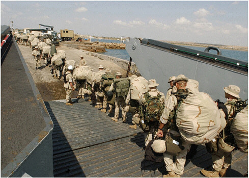
U.S. Marines assigned to the 24th Marine Expeditionary Unit (MEU) Special Operations Capable (SOC) disembark from a Landing Craft Utility (LCU) 1662 assigned to Assault Craft Unit Two (ACU-2). Marines from the 24th MEU are conducting exercises in the U.S. Central Command Area of Responsibility while on a regularly scheduled deployment in support of Operation Enduring Freedom. Support for expeditionary warfare requires close cooperation among the various military services and DOD agencies (Photo courtesy of the U.S. Navy).
The naval METOC enterprise is a complex system of platforms, personnel, and computer systems designed to support operations carried out by U.S. Naval Forces by producing high-quality tailored environmental information products (see Chapters 2 and 3 for greater detail). As pointed out by the scenarios above, the intended consumers of this information include decisionmakers facing a variety of complex choices, some of which may be significantly affected by environmental processes operating at a variety of temporal and spatial scales. As also pointed out in the previous chapters and in these updated scenarios, new approaches to acquiring, managing, and disseminating environmental information to U.S. Naval Forces offer many opportunities for improved tactical decisionmaking.
The current system, however, is limited by what appears to be a lack of performance metrics, including a robust understanding of how platforms and personnel are affected by environmental processes (see Chapter 3). Valid and
|
BOX 6-1 METOC and the U.S. Marine Corps A brief survey of the Marine Corps METOC capability has shown that a Navy-like evolution from pure aviation weather support to a more extensive program including surface weather and oceanographic fore-casting is taking place. Unfortunately, the Marine Corps is many years behind the Navy and Air Force largely due to a lack of personnel, material resources, and educational opportunities. The U.S. Marine Corps is about one-half the size of the U.S. Navy but has one-tenth the officer METOC resources. The U.S. Navy METOC organization has over 1,700 members, whereas the Corps has about 450. Virtually all of the 40 Marine Corps METOC officers have worked their way up through the ranks from weather forecaster to larger leadership roles. The most senior METOC billet is that of a lieutenant colonel (O-5) and is presently being filled by a major (O-4). METOC departments are normally subordinated to intelligence departments. The U.S. Navy presently has two METOC specialty admirals on active duty, a vice admiral, and a lower-half rear admiral. Additionally, the present Oceanographer of the Navy, who comes from a warfighting community, is an upper-half rear admiral who actively champions METOC issues as a member of the staff of the Chief of Naval Operations. The U.S. Marine Corps has no formal education program for its METOC officers. Most officers do not have a bachelor’s degree unless they earned one in an off-duty program on their own. Almost all of the |
quantifiable feedback from warfighters and other operators, while difficult to obtain, is needed if objective criteria for data acquisition are to be established. Limited funding, limited time, and the rapidly evolving nature of naval and expeditionary warfare make sound decisions regarding data acquisition and dissemination a high priority of the naval METOC community.
As discussed in Chapter 3, the spatial and temporal scales of various environmental processes may have a profound effect on efforts to predict future environmental states. Areas where inadequate predictive skill is of concern require greater numbers and more recent observations, either to support data analysis for prediction or to supplant predictions altogether. Determining what level of accuracy is needed in predicting future states of some environmental phenomena is limited by a clear understanding of the sensitivity of platforms and personnel to various environmental conditions. Thus, before rigorous efforts at setting data acquisition priorities can be completed, a fuller account of the impact of various
|
400 officers in the Navy have a college and usually two master’s degrees in oceanography and/or meteorology—a requirement for anyone aspiring to success within the community. The Marine Corps officers the committee interviewed are top-notch performers, and they seemed eager to gain additional education if it were offered. The U.S. Marine Corps follows U.S. Navy standards for equipment at its installations but has very few lightweight deployable systems to take onshore early in an assault. Heavy METMP(R) vans have been developed to support established air operations onshore, but they cannot be easily lifted to shore in the first stages of an assault. For example, no vans were lifted into Kandahar during the war in Afghanistan. The vans also require significant training and support since they can be equipped with up to five different computer operating systems. The U.S. Marine Corps has relied on U.S. Navy METOC support, but the situation is changing. During operations in Afghanistan the radio links back to the ships traversed 500 miles, and communications were limited at best. There is a clear desire to have more METOC support internally and to rely less on the U.S. Navy. Forward-deployed weather and coastal modeling systems have great appeal, and the Corps is becoming more active in these areas. These efforts are constrained by limited support for equipment development and deployment as well as low levels of METOC-expendable supplies. In the current international political environment it is clear that new approaches are needed to provide assault units with deployable and dependable organic METOC support. |
processes on naval operations must be acquired. The General Requirements Database is a good first step, but greater and more clearly defendable establishment of critical thresholds, including compound effects from multiple environmental processes, is needed. With this information in hand, efforts to weigh the benefit of additional information against the cost of acquiring it could be undertaken. Prioritizing data aquisition should follow a rather simple adaptive management process similar to this:
-
Establish mission-critical environmental thresholds for all platforms (e.g., a comprehensive list of environmental processes or phenomena of concern along with numerical values for the threshold that each would impair or severely degrade mission success).
-
Identify and evaluate all relevant environmental data presently collected and readily accessible to the METOC community.
-
Develop a numerical measure of uncertainty that can be applied to all processes or phenomena of concern identified.
-
Develop a METOC decision aid that would prioritize environmental information needed for any given naval activity, based on the mission and platform involved.
-
Determine the least-cost alternative (e.g., change platform, harden platform, acquire additional data) for reducing uncertainty to an acceptable level.
As is often the case, developing the characteristics of a process is much more difficult than developing the information needed to successfully complete each component task. Significant effort should be redirected toward establishing this prerequisite information. Such redirection of effort will largely involve a re-examination of how the needs of U.S. Naval Forces environmental information are established.
Developing More Effective METOC Processes in the Near Term: Leveraging Existing Programs and Resources
Information about environmental conditions is developed from observation or inference. Understanding the nature of environmental processes provides the skill needed to determine when additional observations are needed or to build on existing information to draw inferences about conditions in the future. This latter process is at the heart of traditional forecasting and has been greatly expanded by advances in the capability and capacity of computing facilities and remote sensing. Much work, however, remains to be accomplished if forecasting is to achieve the accuracy and reliability needed at the temporal and spatial scales relevant to many naval operations, especially those taking place in coastal areas.
It will not be possible to obtain, manage, and disseminate environmental information at all scales of interest for all areas of possible naval activities in the foreseeable future. Like many entities with an operational focus, the naval METOC enterprise has evolved to operate on very short production cycles. At present, different information for various geographic areas of concern and different portions of the battlespace (see Figure 6-1) is distributed over multiple sources, many of which are identified by various METOC officers “in stride” as reports are developed for various customers in response to real-time requests. Success in this approach is largely dependent on the knowledge, creativity, and experience of individual METOC officers. Lack of a more cohesive proactive approach to priority setting limits the METOC community’s ability to identify, evaluate, and acquire data and information from nontraditional sources during emerging crises. The METOC community needs to become both a supporter of network-centric operations and a beneficiary of those operations by being an active user of the networks being developed to support them. The METOC enterprise should incorporate network-centric approaches to enable easy and flexible
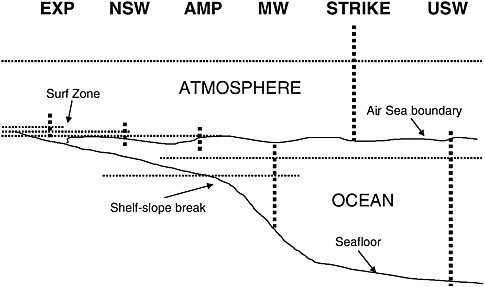
FIGURE 6-1 Stylized cartoon showing distribution of some warfare mission areas relative to major environmental boundaries or gradients. Note that many warfare mission areas occur exclusively above, below, or along the air-sea interface.
interconnectivity among the individual METOC officers and with nontraditional sources of information. This should be done now to leverage the people and knowledge assets currently in place.
As discussed in Chapter 4, special attention should be given to identifying the METOC contribution for nonroutine operations (e.g., evacuation of noncombatants, amphibious warfare, as opposed to activities such as ship tracking or air operations that occur on a daily basis and thus tend to be continuously evaluated and modified). Guidance for identifying broadly needed and significant information across multiple warfare areas should be derived from an understanding of the benefit of additional information for reducing uncertainty versus the cost of improving the content and reliability of environmental information, whether through additional observations, improved understanding of the underlying physical processes, or more powerful forecasting tools that take advantage of both (see Chapter 4 for fuller discussion).
The availability of unmanned airborne vehicles (UAVs) and unmanned underwater vehicles, and their expanded capability to covertly collect intelligence, surveillance, and reconnaissance information in denied areas using a variety of electrooptical and acoustic sensors, creates a largely untapped potential for the unintended use of such information to support the development or validation of METOC products or forecasts. The Oceanographer of the Navy and the Com-
mander of Naval Meteorology and Oceanography Command (CNMOC) should work with the broader community within DOD and elsewhere to expand efforts to make intelligence, surveillance, and reconnaissance information and data with environmental content more accessible to the METOC community while protecting sensitive sources.
Such efforts should include expanded efforts to remove unneeded or particularly sensitive nonenvironmental content; thus, reducing security risk while making the environmentally relevant information or data acquired during intelligence-gathering, surveillance, and reconnaissance efforts more accessible to the METOC community. At the same time, the METOC community’s ability to securely handle sensitive georeferenced material must be expanded. The METOC community should also seek to acquire its own unmanned platforms since concerns about security can limit the availability of such collateral information. In addition, it is strongly recommended that ONR evaluate the potential for exploiting existing intelligence-gathering, surveillance, and reconnaissance sensors as dual-use METOC sensors. Assuming this potential is significant, the Oceanographer of the Navy and CNMOC should work with the DOD community to develop mechanisms to exploit this potential.
Particular emphasis should be placed on forward-deployed assets that are already under the control of theater commands. Data collection could be either specifically tasked or while en route to other missions. Analysis could be easily handled onboard. Care must be taken that the primary missions of the intelligence, reconnaissance, or surveillance operations involved are not hindered or compromised so that such dual-use activities are indeed cost effective.
As discussed in Chapter 5, as network-centric warfare becomes an operational reality, enhanced computing and communications capabilities are changing the way U.S. Naval Forces fight, communicate, and plan. Extensive e-mail and METOC electronic chat room traffic is already overtaking the formal Naval Message System and creating peer-to-peer linkages that are a radical departure from the hierarchical system that has been in place for years. Faster computers and high-speed data links resulting from the IT-21 (Information Technology 21st Century) initiative and the Navy-Marine Corps Internet program are accelerating this dramatic change in the METOC community.
The Office of the Oceanographer of the Navy and CNMOC should work with regional METOC commands to formally define a network-centric concept of operations that embraces peer-to-peer networking within the METOC community while preserving the flexibility and timeliness that have led to the rapid growth in its use. The goal of formalizing this type of exchange should be to improve information content and its usefulness as a source of insight into user and customer needs (e.g., opportunities for data mining, frequency of various types of information requests, identification of systematic problems in information access) while encouraging continued and wider usage. Access to, and the transmission of, METOC data between ships and to shore facilities will
be significant parts of the network-centric warfare transformation. Current efforts to incorporate network-centric principles into METOC operational concepts are only beginning to tap the vast potential of the network-centric operational concepts.
Expanding METOC Capabilities: Logical Next Steps
Existing capabilities for data collection, storage, and dissemination can produce voluminous bodies of information with varying amounts of useful content. The sheer volume of information is already posing an unforeseen challenge as the METOC community and the warfighters they support struggle to match useful information to key users. The Oceanographer of the Navy should ensure that CNMOC, FNMOC, and NAVOCEANO jointly develop a strategic plan for data acquisition over the next 10 to 20 years that prioritizes geographic regions of focus, incorporates an understanding of the limits of environmental information currently available to the METOC community, and evaluates such technologies as distributed databases, advanced information data-mining techniques, and intelligent agent technology.
In addition to geopolitical considerations (which may be fairly fluid on decadal timescales), such a plan should be based on a thorough understanding of what environmental information is currently held or available and which processes or conditions will be of particular concern to various naval missions. Once an initial framework is established, CNMOC and NAVOCEANO should work with operational commanders to evaluate the adequacy of existing critical information (e.g., external variables such as bathymetry/topography, sediment type/land cover) and plan for filling data and information gaps.
Increasing bandwidth, while relaxing some constraints, will undoubtedly lead to further dilution of information content. As the locations of Navy and Marine actions vary across multiple continents and adjoining seas, greater effort must go into developing mechanisms for rapid and efficient environmental characterization that focuses on providing the warfighter with targeted information with a high proportion of useful content while minimizing ancillary or irrelevant information. High-quality data are a must if the quality and utility of information are to be high. The Office of the Oceanographer of the Navy should foster efforts (by providing expertise and access) by ONR to develop and implement a system that promotes optimized environmental characterization, keyed to action-specific warfighter needs during various naval missions or suites of missions.
A significant component of the METOC enterprise, in terms of both fiscal and human resources, is devoted to data collection. Understanding how new data collection, as opposed to use of archived data or numerical extrapolations or interpolations, improves the content of environmental information (i.e., reduces uncertainty) should be a key component of targeted data acquisition. Since data collection resources are limited, and because the cost of data acquisition in denied
areas can be very high, methods for establishing data collection efforts and the research and development that support data collection platform development, should be focused using objective criteria. The Office of the Oceanographer of the Navy and CNMOC should invest in the development of formal and rigorous methods for identifying high-priority data needs that are specific to the platforms and missions to be involved in any potential naval action. Determination of the cost of uncertainty, and focusing on data collection efforts that result in the greatest reduction in total cost of uncertainty, should be given priority at ONR and the Office of the Oceanographer.
Asset allocation should be based on achieving improvements in the most significant parameters of interest. Such an effort will need to be based on a rigorous understanding of critical thresholds for platforms and systems involved as well as the spatial and temporal variability of key parameters and the operational tempo associated with each mission or suite of missions.
At present, there is insufficient continuity of responsibility and feedback for maintaining databases and models. In addition, there is inadequate exchange of data or information collected or managed throughout the Department of the Navy. The Oceanographer of the Navy should clarify the various areas of responsibility and assess the performance of such databases, models, and the tactical decision aids, focusing on their value for individual mission areas. In other words, the value or adequacy of a specific database or model may vary by mission or project, but information collected for a specific mission or project may still be of value to unintended users. Furthermore, at present there is insufficient use of datasets collected by other federal agencies and academia. CNMOC and FNMOC should expand efforts to identify data of value and work with ONR to develop methodologies for evaluating and bringing data into existing METOC systems. Once expanded capabilities to access data and information from a variety of sources, whether from within the DOD, academia, or other nongovernment sources, is established, an effort should be made to develop and implement a system that permits rapid retrieval of environmental data collected in specific geographical areas. Since many METOC products are intended to aid in optimizing the performance of individual weapons systems, provisions should be made to incorporate METOC into weapons systems so that the products are sufficiently integrated to effectively inform and guide operators of the systems (and their supervisors).
The traditional role of the Marine Corps in expeditionary warfare and the renewed focus on littoral operations involving the U.S. Navy continue to drive the need for environmental information in coastal areas where access is frequently denied. Efforts to improve secured, low-profile communications, to alleviate the risk to troops and Marines in coastal areas from chemical and biological agents (either from the tactical deployment of weapons of mass destruction by enemy forces or the destruction of such weapons by friendly forces), and to provide accurate assessments of atmospheric conditions during the planning and imple-
mentation of strike missions have placed a greater emphasis on coastal meteorology. This includes development of predictive meteorological capability at fine scales and intensive data gathering in coastal environments. Military operations in these areas require data in forward operations areas. UAVs are ideally suited for this and provide additional opportunity for data gathering on behalf of METOC. ONR should develop, and the Oceanographer of the Navy should work with operational commands to deploy, atmospheric sensors on UAVs that will permit the collection of essential environmental information without impairing the intelligence, reconnaissance, or surveillance efforts they are largely designed to carry out.
Current efforts to model many littoral processes of importance are promising but are not fully operational. Thus, needed predictive capabilities are not currently available. The Office of the Oceanographer should foster research and development efforts at ONR to integrate mesoscale models with smaller-scale local littoral models.
Changing Attitudes and Approaches: A Longer-Term Vision
The philosophy and approaches used by the Navy’s oceanographic community to supply METOC information to the fleet and Marine Corps can be described in terms of a business model (in fact, the Navy and Marine Corps, like the DOD and most federal agencies, have already adopted this philosophy to some degree, as testified by widespread use of such terms as “user driven” and “customer needs” in planning documents). The present METOC business1 model for providing global and mesoscale forecast fields is well defined and successful. However, the METOC business model for providing enhanced warfighting capabilities does not adequately address customer needs. The current relationship does not facilitate close connectivity or fluid information exchange with the customer. Therefore, it is difficult to quantify the value of environmental information or its impact on warfighting.
It is unclear whether the existing METOC enterprise reflects a strategic or unifying principle that can help the various component parts understand their relationship to one another and the overall goal of the activity. Providing specific advice for improving the overall performance of the METOC enterprise is therefore difficult. A review of various DOD and Department of the Navy guidance documents, however, does suggest that, in order to keep pace with changes now being undertaken by the operational Navy and Marine Corps, the METOC com-
munity needs to reexamine many of its core approaches in a more systematic manner. The de facto business model currently employed by the METOC community for providing enhanced warfighting capabilities should be examined and modified in light of e-commerce principles (e.g., peer-to-peer tasking and Web-enabled customer service) and network-centric warfare concepts of operations. This review should be undertaken at four levels: customer interactions; data collection, data fusion, and information management; sensor networks; and network-centric operations.
To move forward and remain state of the art in environmental forecasting and prediction, resources need to be put into the development of both observational capability and models of processes on small time- and space scales. There is a critical need to improve feedback in data and prediction flow between the METOC community and its customers Failure to do so will compromise the ability of the METOC community to move forward and provide reliable predic-tions. The METOC community must build on existing relationships to strengthen its ties to operational U.S. Naval Forces and to the academic community, especially in the area of data assimilative forecast models.
The role of the METOC enterprise is to provide information about environmental conditions that may be encountered by and thus impact naval operations (including actions of expeditionary forces). In other words, the goal of METOC is to reduce uncertainty, gauged by its cost, to naval operations. This can be done on two levels. At the operational level that forms the primary focus for decisions made by the Oceanographer of the Navy as a resource sponsor or by CNMOC as the head of the METOC claimancy, naval needs are near term and problems are often immediate. ONR, on the other hand, is charged with developing a science and technology investment strategy for the longer term. The approaches appropriate for each endeavor are therefore quite different.
At an operational level, it may be possible to collect additional data that can better constrain boundary or initial conditions for numerical models, thus reducing uncertainty in predictions. The problem then becomes determination of the optimal collection strategy, including which instruments to deploy and where to sample. What is the use of resources that provide the greatest reduction of uncertainty (specifically the cost of uncertainty, which depends on the operational significance)? The appropriate answer depends on sensitivities of the model in question and the available sampling approach, and can be formalized through one of several business decision theories such as Bayesian statistics.
In the presence of perfect battlespace awareness, perfect tactical decisions are theoretically possible.2 Perfect environmental information, however, is
neither achievable or even necessary in many instances. Thus, while uncertainty in environmental predictions introduces costs in terms of the increased risk and occurrence of failure or the costs of contingency plans or suboptimal tactics, the benefit of better information must always be weighed against the cost of developing it. The goal of the METOC community is the reduction of environmental uncertainty in mission planning and operations. The optimum investment strategy is that which reduces environmental uncertainty to the level necessary for a desired probability of mission success and no more. Measures of the cost of uncertainty are not linear but are strongly concentrated on critical thresholds and are weighted differently for different variables and also by the value of the mission. The Office of the Oceanographer of the Navy should promote reduction in the cost of uncertainty as a measure of value, so that a sensible strategy for research and development investments can be developed.
For the research programs at ONR, the investment is not in augmented data collection but in the development of fundamentally better approaches. In contrast to the more applied METOC problem, there is no simple transfer function to equate the cost of research with expected return in reduced uncertainty. Thus, business methods for determination of the optimum rate and direction of investment cannot be employed. Instead, the cost of uncertainty provides an objective measure of research needs among many processes of disciplines that can drive the directions of research. Management wisdom must drive the decisions of funding rates and potential payoffs. ONR should continue to expand its efforts to understand and quantify both uncertainty and its cost in military operations. Furthermore, research priorities should incorporate an understanding of the relative impact uncertainty has on various naval operations, so that research priorities map to areas where the cost of uncertainty is the greatest.
To more fully capture the benefits of improved measures of environmental uncertainty and the cost of that uncertainty, operational commanders need to more fully understand the accuracy of environmental information provided them. The current naval concept of operations for the understanding and assessment of environmental uncertainty is contained primarily in the collective experience of the METOC community, enhanced by informal and nondoctrinal infrastructures; thus, the quality and utility of environmental information will remain uneven and ephemeral, paced by the posting cycle of personnel. The Office of the Oceanographer should work with the U.S. Naval Forces operational commanders to introduce and explain the concept of environmental uncertainty and its value (including development of a common nomenclature for expressing uncertainty). U.S. Naval Forces in general, and the METOC community in particular, should take advantage of the concept of environmental uncertainty in more formal and recognized ways.


