
4
Authorities, Methods, and Practices of Integrated Water Project Planning in River Basins and Coastal Systems
|
Chapter Highlights This chapter describes the Corps’ current approach to integrated water project planning and management within a river basin and coastal system framework, including its governing authorities, methods, and practices. A range of examples is provided in which integrated system planning was (or was not) successfully achieved. |
THE CORPS’ CURRENT AUTHORITIES AND PROCEDURES
Authorities
Integrated river basin and coastal systems planning by the Corps is supported by a number of legislative authorities (Table 4-1). In addition, there are many specific study resolutions and authorities that permit, and in some cases specify, comprehensive examinations of water resources needs and opportunities at the river basin and coastal system scale.
Integrated water project planning is also indicated in a number of authorities supporting an ecosystem approach in Corps activities, whether
TABLE 4-1 Legislative Authorities Supporting Integrated River Basin and Coastal Systems Planning
|
Legislation |
Purpose |
|
River and Harbor and Flood Control Act of 1970, Section 216 (P.L. 91-611) |
Authorizes investigations for modifying existing projects and their operations when found “advisable due to significantly changed physical or economic conditions and for improving the quality of the environment in the overall public interest” |
|
Water Resources Development Act (WRDA) of 1974, Section 22 (as amended) |
Authorizes cooperation with states and Indian tribes in preparing plans for the development, utilization, and conservation of water and related land resources of drainage basins, ecosystems, and watersheds |
|
WRDA of 1986, Section 1135 (as amended) |
Authorizes modifications in the structures or operations of water projects for the purpose of improving the quality of the environment in the public interest; this authority is limited to existing Corps projects |
|
WRDA of 1992, Section 204 |
Authorizes the beneficial use of dredged material for the protection, restoration, and creation of aquatic and ecologically related habitats |
|
WRDA of 1996, Section 206 |
Authorizes aquatic ecosystem restoration and protection projects to be pursued at sites with no existing Corps project |
|
WRDA of 1996, Section 207 |
Authorizes the selection of a dredge material disposal method that is not the least-cost alternative in order to achieve environmental benefits, to include creation of wetlands and shoreline erosion control for the purpose of protecting significant ecological resources |
|
Legislation |
Purpose |
|
WRDA of 1996, Section 221 |
Added watersheds and ecosystems, providing the opportunity for Section 22 authority (WRDA of 1974) to be used for watershed and ecosystem studies |
|
WRDA of 2000, Section 202 |
Provides authority for the Corps to assess the water resource needs of river basins and watersheds, including ecosystem protection and restoration, flood damage reduction, navigation and ports, watershed protection, water supply, and drought preparedness |
ecosystem restoration is the sole objective of the project or one of many. These authorities define compliance requirements, emphasize protection of environmental quality, and endorse federal efforts to advance environmental goals. They include specific authorizations for individual project reconnaissance and feasibility planning as well as programmatic authorities that allow projects for the purposes of restoring and protecting ecological resources to be carried out without specific congressional authorization (e.g., Section 1135 of the Water Resources Development Act [WRDA] of 1986, as amended [P.L. 99-6662] authorizing “Project Modifications for Improvement of Environment”; and Section 206 of the WRDA 1996 authorizing “Aquatic Ecosystem Restoration” [P.L. 104-303]). Unlike Section 1135 projects, whose activities are limited to sites with existing Corps projects, Section 206 projects may be pursued at sites with no existing project. In addition, two WRDA sections authorize beneficial use of dredged material—Section 204 of the WRDA of 1992, as amended (P.L. 102-580), and Section 207 of the WRDA 1996 (P.L. 104-303; Table 4-1).
Section 216 of the River and Harbor and Flood Control Act (P.L. 91-611) authorizes investigations for modifying existing projects and their operations when found “advisable due to significantly changed physical or economic conditions and for improving the quality of the environment in the overall public interest.” After an initial appraisal, the so-called 216 study process can lead to a general investigations study, which can be appropriate for large-scale ecosystem restoration projects linked to existing
civil works projects, but whose costs would be too high for Section 1135, Section 206, or Section 204 authorities.
In 2000, the Corps joined other federal land and water management agencies in adopting a unified federal policy on watershed management (60 Fed. Reg. 62566). The policy has two stated goals: (1) use a watershed approach to prevent and reduce pollution of surface and groundwaters resulting from federal land and resource management activities; and (2) accomplish this in a unified and cost-effective manner. This policy follows a 1995 memorandum of understanding (MOU) among federal land and water management agencies signed to foster an ecosystem approach to natural resource management, protection, and assistance (Appendix A in Corps Engineering Pamphlet No. EP 1165-2-502; available [on-line] at http://www.usace.army.mil/inet/usace-docs/eng-pamphlets/ep1165-2-502/ [accessed March 24, 2004]). This 1995 MOU defines an ecosystem approach as “a method for sustaining or restoring ecological systems and their functions and values.” It specifically integrates ecological, economic, and social factors and states that these are to be “applied within a geographic framework defined primarily by ecological boundaries.” The 1995 MOU states that federal agencies should ensure the utilization of authorities in a way that facilitates, and does not pose barriers to, an ecosystem approach.
U.S. Army Corps of Engineers Planning Guidance
An emphasis on integrated watershed and coastal systems planning is also found in recent Corps policy guidance. The Planning and Guidance Notebook (PGN) states that “civil works planning should incorporate a watershed perspective, whether that planning involves a project feasibility study or a more comprehensive watershed study” (U.S. Army Corps of Engineers, 2000b, Section 2-6) and “every effort shall be made to assure that both economic and environmental value is added to watershed resources” (U.S. Army Corps of Engineers, 2000b, Section 2-1). The PGN also states that planning “should consider the sustainability of future watershed resources, specifically taking into account environmental quality, economic development and social well-being” (U.S. Army Corps of Engineers, 2000b, Section 2-6). Guidance on environmental restoration and protection is summarized in the Digest of Water Resources Policies and Authorities (U.S. Army Corps of Engineers, 1999b) and Ecosystem Restoration: Supporting Policy Information (U.S. Army Corps of Engineers, 1999a). Strong support for watershed and coastal system planning and
ecosystem restoration and protection has also been expressed recently in public testimony by both the Chief of Engineers Lieutenant General R.B Flowers and the Director of Civil Works Major General Robert Griffin (Griffin, 2002; U.S. Senate, Committee on Environment and Public Works, 2002).
Despite the clear authority and strong evidence for internal support for integrated river basin, coastal system, and ecosystem planning, the amount of focused guidance for such planning is relatively limited compared to that for economic evaluation of water projects. Basic requirements for planning Corps projects were formalized by Congress in the WRDA 1986 (P.L. 99-662), which requires two levels of study for each Corps project: a reconnaissance study and a feasibility study (Box 4-1). These two levels of study are reflected in the PGN, which remains the primary planning guidance for all Corps projects. The current version of the PGN (dated April 22, 2000) contains six steps that must be followed by the Corps when planning water resources projects (U.S. Army Corps of Engineers, 2000c, p. 2-3):
Step 1: Identify problems and opportunities
Step 2: Inventory and forecast conditions
Step 3: Formulate alternative plans
Step 4: Evaluate alternative plans
Step 5: Compare alternative plans
Step 6: Select a plan
Step 1 of the planning process is to identify the problems and opportunities that reflect the priorities and preferences of the local sponsor, the federal government, and others participating in the planning study. This “scoping” process leads to a statement of the “planning objectives” that describe the desired outcome of the plan. Step 2 is to develop an inventory and forecast relevant resources in the planning area under current and future “without-project” conditions.
The first phase of the plan formulation process (Step 3) is identification of the structural and nonstructural management alternatives that would achieve the objectives of study participants. Management alternatives are then evaluated (Step 4) by forecasting the most likely “with-project condition” expected under each alternative plan (U.S. Army Corps of Engineers, 2000c, p. 2-6). This includes a characterization of the beneficial and adverse social, environmental, and economic effects of each alternative. In Step 5, the Corps compares the beneficial and adverse effects of the various alternative plans (including the no-action alternative). After making
this comparison, the plans are ranked. The process culminates (Step 6) in the selection of a project plan from the alternatives or the decision to recommend that no action be taken. The criteria for selecting the recommended plan depend on the type of plan and whether the project outputs support national economic development (NED), national ecosystem restoration (NER), or a combination of both. With the exception of projects explicitly focused on ecosystem restoration (therefore supporting NER), Corps policy mandates the most cost-effective (highest net benefits) implementable alternative as the alternative, described in Box 4-2 (U.S. Army Corps of Engineers, 2000c, p. 2-10).
Neither spatial integration of projects within a watershed nor evaluation of the cumulative effects of multiple projects within a watershed is incorporated as an explicit element of the six project planning steps in the PGN. The project planning process is limited to the planning area as defined in the federal Economic and Environmental Principles and Guidelines for Water and Related Land Resources Implementation Studies (P&G): “the planning area is a geographic space with an identified boundary that includes: the area identified in the study’s authorizing document” (WRC, 1983, Section 1.4[7]). Hence, an evaluation of projects in the upper reaches of a river basin is not explicitly required to consider downstream effects or the cumulative impact of multiple, independent projects. Requirements in the P&G for mitigating adverse effects of projects and the “scoping process” under the National Environmental Policy Act (NEPA) (40 Fed. Reg. 1500-1508) do not explicitly address system-wide effects of projects within a watershed or coastal system. Alternative project plans can be compared based on their beneficial and adverse effects within the immediate project domain. In the sections of the PGN that provide supporting guidance for each of the six project planning steps, there is a single paragraph (U.S. Army Corps of Engineers, 2000b, Section 2-6) that calls for “a watershed perspective.” Unlike the detailed instructions for cost-benefit analysis, public participation, and cost-sharing, this paragraph contains four general statements about the need to take into account “the interconnectedness of water and land resources” (U.S. Army Corps of Engineers, 2000b, Section 2-6). Procedures for implementing a watershed or coastal system perspective are not identified, nor are any other documents referenced for this purpose in the PGN. Moreover, in some cases, the existing guidance may, albeit unintentionally, conflict with the objective of taking a broader systems approach, as in the case of the language that effectively encourages the comparison of alternative project plans based on their beneficial and adverse effects within the immediate (e.g., local) project domain.
|
BOX 4-1 After a potential problem has been identified either by the Corps or by a local authority, the Corps must first determine the extent of the problem and the likelihood that it can implement a solution. This is called the reconnaissance phase; and it is 100 percent funded by the federal government, must be completed within one year, and cannot exceed $100,000. The Corps district office performs this study, which also includes identifying a prospective local sponsor for cost-sharing during the feasibility phase. The reconnaissance study will recommend either that a feasibility study be conducted or that all further planning be discontinued. If the decision is made to continue on to the feasibility phase, the Corps and the local sponsor will negotiate a project study plan (PSP) and a feasibility cost-sharing arrangement (FCSA). The PSP will include the scientific, engineering, and management activities consisting of a detailed agreement of the task descriptions, task responsibilities, and task milestones. The cost-sharing responsibility of the local sponsor is nonnegotiable as outlined in the WRDA 1986 (P.L. 99-662). The federal government will split the cost of the activities of the feasibility phase 50-50 with the local sponsor, who may substitute 25 percent of its 50 percent share with in-kind products and services. The intent of the in-kind contribution was to assist communities with financial difficulties in meeting their 50 percent cost-share obligation. Many communities make use of this in-kind opportunity. Once it is determined that the Corps’ service is needed and a local cost-sharing sponsor has signed the FCSA, the Corps will hold at least one public workshop. Thus begins the feasibility phase, which has no time restriction but typically lasts approximately four to five years. At this stage it is determined whether a federal project is appropriate for solving the identified water resource problem(s). During this phase the Corps receives public input, and alternative plans are developed and revised. Project design characteristics are outlined, project costs are estimated, benefit-cost ratios are determined, and the national economic development (NED) alternative is identified (see Box 4-2 for explanation of the NED alternative). In some cases the local sponsor |
|
may decide on an alternative that exceeds the NED alternative (e.g., desire for protection against a 200-year flood level, rather than a 100-year level), in which case the local sponsor must agree to cover the additional costs if the Corps agrees to proceed with the local sponsor’s suggested alternative (U.S. Army Corps of Engineers, 2001b). After the alternative plans have been developed, the Corps may convene an alternative formulation briefing (AFB) to present the plan alternatives, the NED plan, and the recommended alternative plan. After the AFB, the Corps will complete its draft feasibility report and submit it to Corps Headquarters and the Secretary of the Army, as well as other relevant federal agencies and the U.S. Office of Management and Budget. The public will then have 45 days to review the report and the Corps will hold a final public meeting to obtain further comments. Within approximately six months of submitting the AFB, the Corps will release a revised feasibility report. During this time the Corps is also concluding the National Environmental Policy Act’s required environmental impact statement (40 Fed. Reg. 1500-1508). The feasibility phase ends when the local sponsor and the Corps decide on a final plan and sign the division engineer’s notice, and this notice recommends to the Corps’ chief of engineers that the plan should be approved. Directly after signing the division engineer’s notice, the district engineer will complete a preconstruction engineering and design (PED) cost-sharing agreement. This outlines the required preliminary specifications and identification of the lands, easements, rights of way, relocations, and disposal areas (LERRDs). This process takes about two years to complete. The PED is then sent to the Secretary of the Army, and the Corps’ chief of engineers recommends approval of the project. |
An important step would therefore be to review these main planning guidance documents and identify cases in which better and more explicit language would bring guidance for day-to-day project planning into closer conformity with general statements of principle and would clearly endorse planning on broader spatial and temporal scales. This effort should draw on the practical insights available from previously implemented Corps projects, where explicit planning on the scale of watersheds and/or coastal systems was carried out.
|
BOX 4-2 The concept of “NED benefits” and the incorporation of these benefits into a “NED account” currently provide the foundation for the evaluation of proposed water resource projects undertaken by the Corps. The procedures, principles, and practices for evaluating Corps water resource projects come from two main sources. One is the federal Economic and Environmental Principles and Guidelines for Water and Related Land Resources Implementation Studies, also known as the P&G, published in 1983, which provides a set of general principles and practices to be followed by the Corps as well as by other federal water-planning agencies (WRC, 1983). The second is the Planning Guidance Notebook (PGN), a Corps document (U.S. Army Corps of Engineers, 2000b). The PGN requires the Corps to follow a planning process that includes formulation, evaluation, comparison, and selection of alternative plans for water resource projects. In all cases, alternative plans must be evaluated and compared with reference to the federal objective. This objective is to “contribute to national economic development (NED) consistent with protecting the nation’s environment, in accordance with national environmental statutes, applicable executive orders, and other Federal planning requirements” (U.S. Army Corps of Engineers, 2000b, Section 2-2 [a]). The results of this analysis are presented in terms of the NED account for the project. Benefits in the NED account are intended to show how the plan increases the production and/or consumption potential of the national economy, while costs in the NED account are intended to measure the national or social opportunity costs of implementing the plan. For all project purposes except ecosystem restoration, “the alternative plan that reasonably maximizes net economic benefits consistent with protecting the nation’s environment, the NED plan, is to be selected” (U.S. Army Corps of Engineers, 2000b, Section 2-2, f [1]). In practice, however, exceptions to this selection criterion are permitted if “the Secretary of a department or head of an independent agency grants an exception when there is some overriding reason for selecting another plan, based upon Federal, state, local, and international concerns” (U.S. Army Corps of Engineers, 2000b, Section 2-2, f [1]). |
|
The guidance for measuring NED benefits and costs provided in the P&G and the PGN is based on standard principles of benefit-cost analysis for measuring social benefits and costs of public programs. As a result, the “N” in NED signifies that benefits and costs outside the “private or commercial” realm are to be counted, not just those benefits or costs experienced by private parties, such as the cost of purchasing land. For example, when land is donated for use in a water project, the P&G requires that a NED cost be estimated because the land has value for alternative uses, even though the land has no budgetary cost. Similarly, the P&G requires that NED benefits include “the value of output resulting from external economies caused by a plan.” As noted in a recent National Research Council (NRC, 1999b) report, the basic economic guidance provided in the P&G for identifying and estimating NED benefits and costs is “largely sound.” However, the same report also notes that there is a need for broadening and updating the P&G. An area of particular concern is Corps practice for incorporating a range of environmental effects in water project planning. On one hand, both the P&G and the PGN recognize that water projects may have a range of environmental effects, and the guidance provided by the PGN makes it clear that such effects are to be an explicit part of the overall project planning process. On the other hand, there remains disagreement about whether and how to attach monetary measures to these environmental effects. Currently these effects are not included as project benefits and costs to be evaluated along with more traditional NED benefits and costs. Nonetheless, environmental effects can indirectly affect the NED assessment of a project when environmental considerations cause constraints on project design, which in turn can affect NED project benefits or costs. |
In some instances, drafting more explicit guidance on how to incorporate broader systems effects into project planning involves nothing more than bringing practice into line with the traditional policy objective of maximizing the NED benefits from water projects. For example, the fact that evaluation of projects in the upper reaches of a river basin is not explicitly required to consider downstream or cumulative effects does not mean that such effects might not be considered. At the same time, the
absence of specific instructions can make it more difficult for a project manager to justify the effort involved, while also leaving open the option of not considering these costs. As a result, the evaluation can lead to incorrect estimates of the true NED benefits and costs of upstream water projects from a social benefit-cost standpoint as illustrated in Box 4-3.
Recommendation 4-1: The Corps should undertake a thorough review of the documents issued to guide water resource planning “in the field” to bring such guidance into closer conformity with generally stated principles that support integrated water resources planning.
When performing this review, it is important to keep in mind that no two watersheds or coastal systems are alike in their hydrologic, ecologic, social, and economic conditions; therefore, creating specific instructions for integrated systems planning is neither advisable nor achievable. None-theless, clear guidelines regarding identification of the suite of potential objectives and impacts of a water project, and the basis for weighing the costs and benefits and developing effective trade-offs, are necessary for effective integrated water resources planning.
Practice
Although the Corps’ planning documents lack comprehensive guidance on performing integrated river basin and coastal system studies, in practice the Corps is often able to conduct such analyses. District offices can call on general water resource planning principles, guiding authorities, and regulations to support development of an integrated plan. Doing so requires some initiative on the part of the individual project managers not only to develop an approach, but also to establish the necessary authority and, typically, to generate supplemental funding. Individual initiative may also be called upon because such efforts may be performed at the expense of other planning activities, activities that may lead more directly to funded construction projects and to addressing sponsor demands.
Typically, integrated water planning investigations at a watershed or coastal system scale are mandated by specific authorizing legislation. When given such authorization, the Corps has proven that it is capable of identifying salient issues, incorporating stakeholder interests, and building sophisticated models representing system-wide water flow and sediment loads, as well as socioeconomic aspects of proposed projects. Examples of these capabilities are given later in this chapter.
|
BOX 4-3 River basins and coastal waters are economically as well as physically and biologically interconnected. For example, flood control projects constructed upstream may affect the likelihood of flooding downstream and influence the need for dredging and shore protection in coastal streams. A series of local water projects undertaken separately for local sponsors may have cumulative effects on other activities, such as fisheries and agriculture elsewhere in the watershed. Interactions of the sort described above affect the NED benefits and costs of publicly financed water projects. Consider the hypothetical case of a flood control project proposed at site A in a watershed. Assume that two alternative flood control projects are under consideration and that the estimated local NED benefits and NED costs of each alternative are shown in the table below. If the choice of alternative is made only with reference to estimated local NED benefits and costs, then alternative 1 would be selected as the “alternative plan that reasonably maximizes net economic benefits”(U.S. Army Corps of Engineers, 2000b, Section 2-3). Suppose, however, that implementing alternative 1 would have negative economic effects in another part of the watershed not included in the local plan. In principle these costs should also be included as NED costs because they reflect “the value of that which is foregone when a choice of a particular plan or measure is made” (U.S. Army Corps of Engineers, 2000b, Section 2-4). Doing so would cause Alternative 2, which does not entail these costs, to be identified as the NED alternative plan. Comparison of NED Benefits and Costs (millions of dollars)
|
|
On one hand, sections of the PGN recognize that costs incurred outside the boundaries of the immediate local project should be taken into account. “Negative externalities” are listed as a component of “other direct costs” that should be included in estimated NED economic costs (U.S. Army Corps of Engineers, 2000b, Section 2-4), and the section of the PGN dealing with flood control projects states that “[d]ownstream consequences of dams on flood risk are also analyzed in a risk-based framework” (U.S. Army Corps of Engineers, 2000b, Section 3-3). On the other hand, failure to explicitly analyze the effects of individual projects as part of a broader system can increase the chance that potentially important external costs (or benefits) of specific projects may be overlooked. In such cases, incomplete accounting of the full NED benefits and costs can prevent projects with the greatest watershed net economic benefits from being selected. |
If project authorization and associated funding directives do not mandate examining the broader impacts of a project, including the cumulative effects of related projects, pressures to efficiently complete a study and satisfy sponsor expectations can narrow project focus to local costs and benefits, leading to cursory river basin or coastal system planning. Investigation may focus on immediate with- and without-project conditions to evaluate risks, costs, and benefits of a project. Broader investigations and modeling (such as those that integrate water quality, changes in rainfall patterns and sea level, and habitat response and ecosystem functioning, as well as the cumulative effects of other projects and permits) within a watershed generally require specific effort and costs and introduce possible project delays. Further, development and verification of such models are not generally the purview of Corps project managers and district engineers. Therefore, an outstanding challenge for the Corps is to incorporate integrated, systems-level analysis in the evaluation of routine water projects.
Spatial integration of water resources projects among Corps districts at the division level is informally addressed by a Policy Review Board. The Policy Review Board (consisting of district office representatives and the division-level executives) is given the opportunity to review projects within
a watershed, but the review is informally structured to raise issues to review plans for projects within the division.
Within Corps divisions and districts, project managers are expected to provide the coordination necessary to ensure that projects will not adversely affect one another. Turnover in personnel can work against consistent integration among projects. Procedures for project integration (with the exception of the use of hydraulics models) rely chiefly on communication among project engineers and planners. Managers of three different branches of the New Orleans District’s Division of Planning, Programs and Project Management indicated the need for geographic information systems (GIS) and habitat models to simulate project effects on water quality, storm surge, habitat variables, water level, and stream flow. Predictive models and tools of this nature are not currently prescribed in the federal P&G or other more specific guidance documents.
Several procedures have been adopted by the Corps to enhance project planning and, indirectly, multi-project integration. In 1993, the Office of Federal Procurement promulgated rules for a procedure called “value engineering” (Office of Management and Budget [OMB] Circular No. A-131, May 21, 1993). These rules, authorized by the WRDA of 1986 (P.L. 99-662) require that federal departments and agencies use value engineering as a management tool to reduce program and acquisition costs. In response, the Corps promulgated procedures to provide oversight during the planning of all projects with estimated costs of $1 million or more. The Corps’ value engineering policy requires an independent assessment of each major project during both the planning and the design phases. The “value engineer” is a Corps employee not assigned to the project being evaluated. The value engineering team often includes employees from other Corps district offices. Another procedure that may enhance project planning and, indirectly, multi-project integration is the project management business process, which is based on a stated Corps commitment to provide “customer service” in delivering quality projects and includes elements of coordinated management, teamwork, partnering, and balancing of competing demands. Although not explicitly designed to foster integrated river basin and coastal system project planning, the guidelines for both of these programs could be revised to include system integration and environmental stewardship as explicit review objectives. These programs also provide useful experience for the Corps in evaluating operational models for program integration.
For each major Corps project, an independent technical review (ITR) team or committee is also appointed. The ITR is composed of a group of independent technical professionals (external to the project) who examine project designs that are complete or near complete to see if improvements or
cost savings are possible. The main goal is to determine if the current design for the project satisfies the objectives and to see if there is a more effective or efficient way to accomplish the objective of the project. Like value engineering, the ITR is project specific and does not ensure integration or compatibility within a watershed. However, experience gained through both of these mechanisms may be useful in designing an approach for integrating Corps projects within river basins and coastal systems.
Watershed studies are authorized by the PGN (U.S. Army Corps of Engineers, 2000b, Section 3-9 [c]) and are defined as “planning initiatives that have a multi-purpose and multi-objective scope and that accommodate flexibility and collaboration in the formulation and evaluation process.” These studies require a 50 percent cost-share from a local sponsor, which has limited the use of this provision for watershed-level planning. Similarly, multi-purpose flood mitigation and riverine restoration are described in the PGN (U.S. Army Corps of Engineers, 2000b, Section 3-9) and authorized by Congress in the WRDA 1999 (P.L. 106-53, Section 212). However, no funds were appropriated for this program in fiscal year (FY) 2001 and no funds were included in the administration’s budget for FY 2002 (U.S. Department of the Army, 2002).
Trade-Off Analyses
Balancing the economic and the environmental benefits and costs of water projects involves both identifying and evaluating potential trade-offs between these two goals.
Although effective water resource decision making at all levels (e.g., local as well as systems) requires an improved ability to evaluate these trade-offs, the need is likely to increase as the Corps moves toward broader and more integrated approaches to planning. Although the PGN recognizes the need for accounting for the environmental effects of water projects, the challenge of placing monetary value on environmental costs and benefits of water projects has prevented the Corps from weighing them directly along with the traditional economic benefits identified for inclusion in the NED account. Instead, these effects are included in the overall project plan through NER accounts.
The broad issue is not whether but how to incorporate environmental benefits and costs into the Corps’ planning process. The PGN identifies ecosystem restoration as one of the “primary missions” of the Corps’ civil
works program and defines NER outputs as increases or decreases in the net quantity or quality of desired ecosystem resources (U.S. Army Corps of Engineers, 2001b, Section 2-2[b]). In cases in which ecosystem restoration is a primary objective, the PGN goes on to require that ecosystem plans are to be “formulated and evaluated in terms of their net contribution to increases in ecosystem value (NER outputs), expressed in nonmonetary units” (U.S. Army Corps of Engineers, 2001b, Section 2-2[b]).
In principle, including estimates of monetary benefits and the costs of changes in the availability and quality of environmental goods caused by water projects is consistent with the social accounting framework of benefit-cost analysis that underlies the preparation of the NED accounts. In practice, estimating the value of environmental goods is challenging.
Unlike many of the effects traditionally captured in the NED accounting framework, outputs of ecological restoration projects tend to include intangible values such as endangered species protection, and aquatic ecosystem protection or restoration, as well as aesthetic values (NRC, 1999b). Economists have developed a range of methods for assigning monetary values to such intangible effects, and the Corps has devoted considerable intellectual energy and resources to examine how these methods might be used in Corps planning and evaluation activities (NRC, 1999b).
Implementing such methods would effectively incorporate a form of environmental stewardship in traditional Corps planning activities by broadening the historical objective of maximizing net national economic benefits to include a range of formally monetized environmental benefits and costs. An advantage of adopting such an approach is that the environmental effects of Corps activities could then be directly evaluated with more traditional NED benefits and costs. Corps projects that improved the quantity and/or quality of environmental goods would increase net economic benefits, while actions that had the opposite effect would reduce net benefits.
Although the concept of subjecting all project effects to a common metric such as money may be intellectually appealing, there are both intellectual and practical reasons for treading cautiously. First, setting aside the issue of how to monetize nonmonetary effects, there is considerable scientific uncertainty about how to value and model nonmonetary effects. Second, although economists generally agree that many environmental effects can be translated into monetary terms, there continues to be debate on how this can best be accomplished. Last, carrying out methods to value and measure environmental goods can be costly in terms of both time and money, which may limit the ability of the Corps to routinely apply these
methods, as it does more traditional NED measures of benefit and cost (NRC, 1999b).
Because of these obstacles, the Corps has taken alternative approaches to integrate NER and NED considerations into project planning in ways that are systematic, yet stop short of monetizing environmental benefits. In some watershed plans, environmental restoration has been included as part of the total NED cost of each alternative, as in the case of alternatives considered under the Sacramento-San Joaquin Watershed plan.
A disadvantage of handling environmental effects in this manner is that otherwise superior alternatives can be overlooked by procedures that include the economic costs but not the economic benefits of environmental restoration. Beneficial use of dredged materials offers one example of how failure to include monetary benefits of environmental improvements can create less than desirable incentives. As illustrated above, one potential beneficial use of dredged materials is to create wetlands. However, current policies and practices do not allow dollar values to be assigned to the creation of such wetlands. Failure to assign monetary benefits to wetland creation as a “beneficial use” of dredged materials has two potential consequences. At the margin, this practice makes it somewhat harder to justify incurring the extra disposal costs associated with using dredged material for wetland creation in financial terms because there is no monetary benefit that can offset these costs. It also may provide financial incentives to favor uses with benefits that can be more readily monetized.
One potentially promising approach that has recently been used in some projects is the application of formal analytical frameworks to aid decision makers in identifying trade-offs that may arise between changes in environmental quantity or quality in the NER accounts that are not expressed in monetary terms and to project net benefit or cost in the NED account.
In the case of the Central and Southern Florida Indian River Lagoon South Project, environmental and economic benefits and costs have been evaluated through the use of cost-effectiveness and incremental cost analysis. Under this procedure, the ecosystem benefits of alternative water projects were measured in terms of physical dimensions, such as acres of wetlands or habitat units. Estimates are then made of the economic costs of achieving these physical changes in output. The objective was to determine the least-cost means of achieving each possible level of environmental benefit, measured in physical units. The resulting lists of “least-cost plans” were then compared to each other to identify those plans that produced more of the environmental benefits at the same cost or at a lesser cost than other alternatives.
These and similar approaches to planning, which fall broadly under the rubric of “trade-off analysis,” do not seek to arrive at a monetary “bottom line” that implicitly weighs both the environmental and the economic effects of projects. Rather, the purpose of a trade-off analysis is to present information about multiple attributes of projects (e.g., environmental and economic effects) in a consistent fashion that allows decision makers to better understand the range and scope of trade-offs between the NED and NER effects of different projects. Presenting such trade-offs allows the range of choices among competing projects to be identified clearly and systematically, while at the same time acknowledging that actually weighing these options against others requires making judgments about different and competing project attributes and taking into consideration science, values, and stakeholder interests.
The use of trade-off analysis as an analytical framework for integrating NER and NED effects into project planning offers a feasible alternative for allowing the Corps to engage in systematic project planning, given the continuing controversy over the reliability and validity of existing approaches for monetizing environmental benefits and costs. The Corps has developed extensive guidelines for how to undertake such analysis (Institute for Water Resources, 2002). At the same time, the example of how environmental benefits of wetlands are (at least implicitly) treated in the analysis of beneficial use of dredged materials (discussed later in this chapter) points to the advantages of developing at least some methods for valuing the economic costs and benefits of environmental restoration.
At the institutional level, the Corps is aware of the conceptual issues and current best practices for systematically including the environmental effects of projects along with the more traditional NED benefits and costs. The challenge, as noted by another panel of this National Research Council (NRC, 2004b) study, is to determine how best to include these issues and practices in the documents that guide day-to-day planning. This is of particular importance during water resource planning of large, complex multi-component projects (such as the Everglades restoration project) or of individual projects that may have an impact on large, complex systems.
Recommendation 4-2: The Corps should continue its current efforts to facilitate the systematic integration of information provided in the NED and NER accounts through the application of trade-off analysis.
Recommendation 4-3: The Corps should continue to take steps, such as those outlined in New Directions in Water Resources Planning for the U.S. Army Corps of Engineers (NRC, 1999b) and Analytical Methods
and Approaches for Water Resources Project Planning (NRC, 2004b) to develop protocols and standards for incorporating environmental benefits and costs into project planning in a manner that is comparable to traditional NED benefits and costs.
In addition, planning projects at a watershed or coastal system scale is more likely to require the consideration of nonstructural as well as structural approaches to deal with issues such as flood control and beach erosion. The federal P&G requires that nonstructural approaches to flood control be considered as alternatives to structural approaches. The P&G procedures for estimating the benefits and costs of nonstructural approaches, however, assume that differences in value between developed land and land left fallow as a nonstructural measure fully reflect the social value of developed and undeveloped land in floodplains, watersheds, or coastal areas. This assumption may not be correct and hence may unintentionally bias project choices in favor of structural approaches. Moreover, implementing nonstructural solutions in cases where development has already occurred can involve challenging issues raised by the need to compensate those who have made investments in floodplains under reasonable assumptions about government policy. The costs of such compensation may increase the cost of nonstructural projects without affecting their actual social cost since the required compensations are essentially redistributed from a society that gains from the nonstructural approach to those who suffer economic and social harm as a consequence.
EXAMPLES OF THE CORPS’ USE OF INTEGRATED PLANNING IN RIVER BASINS AND COASTAL SYSTEMS
In reviewing Corps performance in using an integrated approach to water project planning in river basin and coastal systems, it is useful to examine instances in which the Corps has specifically completed such studies. These examples serve to illustrate the Corps’ capabilities in this regard and, by extension, the conditions necessary to allow such studies to take place. Some examples also illustrate that integrated planning does not necessarily lead to integrated water resources management. Other factors, such as methodological, political, or jurisdictional conflicts can stand between the formulation and implementation of a coherent plan.
It is not difficult to find examples of projects in which the study objectives include a systems approach that specifically incorporates mul-
tiple scales, multiple objectives (including environmental stewardship), and diverse stakeholders. Many of the most noteworthy projects have a high profile, involve significant environmental and economic resources, and involve extensive field data sets, GIS support, simulation models, and decision support systems (Box 4-4).
With environmental restoration now established as a central Corps mission, smaller watershed studies are developed with the specific aim of identifying opportunities for that purpose. In collaboration with state and local jurisdictions, project authorities are developed with the objective of evaluating the condition of a watershed, often leading to a watershed plan that identifies local actions that may have beneficial regional effects. For example, in the Baltimore-Washington area, the Corps’ Baltimore District is engaged in a variety of watershed studies motivated by regional objectives including reducing sediment and nutrient input to the Chesapeake Bay; restoring freshwater fisheries impacted by urbanization and by existing water projects for flood control, navigation, and water supply; and restoring aquatic and wildlife habitat. A watershed-based ecosystem restoration approach is used in these studies, leading to the identification of subbasin watersheds as potential project areas, rather than the traditional site-specific selections to identify potential restoration projects. Collaboration among the U.S. Environmental Protection Agency, the State of Maryland, the District of Columbia, the City of Baltimore, Maryland county governments, and other local authorities has resulted in additional broad objectives including water quality improvement, brownfield restoration, economic revitalization, and the public use and enjoyment of urban rivers. Interaction among diverse agencies can also work against development of specific projects. For example, despite agreement on broader objectives for ecosystem restoration, differences in specific priorities and preferred methodologies can halt a project, even after reconnaissance and feasibility studies identify worthwhile goals.
In the traditional water resource areas of flood damage reduction and navigation, integrated water resource planning must generally incorporate significant existing civil works. In these cases, integrated studies must typically balance the cumulative impacts of installed structures, the increased value now placed on ecosystem resources, and a constituency with a strong vested interest in maintaining the water resource benefits provided by installed works (an example of this issue is given in the case study that follows).
|
BOX 4-4 Comprehensive Everglades Restoration Program Louisiana Comprehensive Coastwide Ecosystem Restoration Study Upper Mississippi Navigation Study Upper Mississippi Comprehensive Plan Missouri River Master Plan Hudson River Study Lower Snake River Salmon Passage Study Sacramento-San Joaquin Rivers Comprehensive Plan California Coastal Master Plan Ohio River Main Stem Study Great Lakes Study Northern Gulf of Mexico Regional Sediment Management Demonstration Project |
Case Study: Sacramento and San Joaquin River Comprehensive Plan. Following disastrous flooding on the Sacramento and San Joaquin Rivers in January 1997, California and federal legislation authorized the development of comprehensive plans for flood damage reduction and ecosystem restoration. Preparation of the plan was a joint effort of the Reclamation Board of California and the Corps. The goals of the Sacramento and San Joaquin River Comprehensive Study (comprehensive plan) were to reduce threats to public health and safety, reduce flood damages, and restore the ecosystem along the floodplain corridors. These goals expand on those of the original flood management system, developed over the twentieth century, which were to manage and redirect flood flows for economic (primarily agricultural) use and navigation. Water conveyance has superceded navigation as an important use, and ecosystem restoration has been added as an additional objective.
A major element of the comprehensive plan involves developing tools to describe the behavior of the complete flood conveyance system. A focus area is the modeling capability of demonstrating how changes in one part of the system will affect the performance of the system as a whole. The technical tools consist of computer models and an extensive information data base that support a system-wide approach.
The major findings of the plan are the following (California Reclamation Board and the U.S. Army Corps of Engineers, 2002):
-
The system cannot safely convey the flows that it was formerly considered capable of accommodating.
-
If levee reliability were improved system-wide, substantial increases in flood storage capacity would be necessary to avoid transferring increased flood risks to downstream areas.
-
A comprehensive solution to improve public safety, reduce flood damages, and restore degraded ecosystems will require a combination of measures that increase conveyance capacity, increase flood storage, and improve floodplain management.
As originally conceived, the Sacramento-San Joaquin River Study lead to a single master plan specifying flood damage reduction and ecosystem restoration projects throughout California’s Central Valley. Although the comprehensive plan reports wide agreement that the system requires improvement, it also concludes that there is little agreement on the measures that should be used and, therefore, does not recommend any particular projects. Instead, the comprehensive plan establishes a set of general principles to be used as a guide for future projects and establishes an approach to evaluate system-wide effects for all projects, regardless of scale. The plan also provides an administrative structure to oversee project analyses and to consistently apply emerging principles for maintaining the flood management system and developing future projects. The comprehensive plan also advocates a science-based adaptive assessment and management approach, with explicit incorporation of updated data bases, performance measures, coordination among resource management programs, peer review, and ongoing technical studies, including consideration of potential climate change. It also uses systems models as the basis for operation and maintenance of the existing systems as well as for future project development. As described in the interim report, the comprehensive plan establishes (1) a set of principles to guide future projects; (2) an approach to develop projects with consideration for system-wide effects; and (3) an organization to consistently apply the guiding principles in maintaining the flood management system and developing future projects.
Integrated Planning in the Mississippi River Basin
In the Mississippi River basin, integrated water planning becomes essential and faces the full range of jurisdictional hurdles. For more than 150 years, the Corps has developed and maintained an extensive system of levees, locks and dams, and channel modifications to support navigation and to control flood damage. Recent and ongoing examples of integrated planning efforts in this basin include the Upper Mississippi Navigation Study, the Upper Mississippi Comprehensive Plan, the Ohio River Main Stem Study, and ongoing attempts to revise the Missouri River Master Plan. As social values have shifted and recognition of the environmental degradation of the delta and the Gulf of Mexico has increased, the Corps’ role has shifted from that of master engineer to that of manager within an enormously complex political and jurisdictional system. The case study below describes the evolution of the Corps strategy for ecosystem restoration within the Mississippi River Basin, and specifically within its lower portion—the Louisiana coastal zone. This case study shows that the Corps has become increasingly experienced in jointly planning environmental restoration projects, especially high-profile and complex restoration projects, with other agencies and stakeholders.
Case Study: Systems-Level Approach for Environmental Restoration in Coastal Louisiana. Many environmental problems in the Louisiana coastal area stem from human alteration of the geologic, hydrologic, and biologic processes that created the Mississippi River deltaic plain. Subsidence, sea-level rise, wetland loss, saltwater intrusion, landward migration of estuarine species, and barrier island erosion are all attributed to a combination of human-induced and natural processes. Louisiana has lost more than 1,500 square miles of coastal wetlands since 1956 (Figure 4-1). The conversion of wetlands to open water in coastal Louisiana accounts for about 80 percent of the coastal wetland loss in the continental United States.
The economic value of Louisiana’s coastal wetlands varies depending upon what is included in the analysis, but estimates range from $2 billion to $17.9 billion per year. It is estimated that more than $100 billion in natural resources (including about one-third of the commercial fish and shellfish harvests in the contiguous United States and 20 percent of the nation’s waterfowl) could be lost over the next 50 years if Louisiana’s coastal wetlands continue to disappear at the present rate (Coalition to Restore Coastal Louisiana, 1999). These coastal wetlands are important natural defenses for the nation’s energy infrastructure. Roughly 80 percent of the
outer continental shelf’s oil and gas is processed along the Louisiana coast, as well as two-thirds of the nation’s imported oil. The wetlands also protect coastal communities (70 percent of the population of Louisiana) from storm surges. The annual storm protection value of Louisiana’s coastal wetlands is estimated at between $208 and $904 per acre (Costanza et al., 1989).
Efforts to combat wetland loss in coastal Louisiana have been under way for roughly 35 years. In 1967, a U.S. House Resolution (H.R. 112, 86th Congress) directed the Corps (authorized under Section 3 of the Rivers and Harbors Act of 1902, 33 U.S.C. 418) to develop a coast-wide strategy for Louisiana “in the interest of hurricane protection, prevention of saltwater intrusion, preservation of fish and wildlife, prevention of erosion, and related water resource purposes.” In subsequent years the Corps has planned and built freshwater diversions from the Mississippi River at Caernarvon and Davis Pond, with the State of Louisiana providing the local cost-share. In 1978, Louisiana established a state coastal zone management program that emphasized controlling activities that contributed to wetland loss. The state’s program became a federally approved coastal zone management program in 1980. In 1981, the Louisiana legislature established the Coastal Environment Protection Trust Fund and appropriated $35 million for 17 pilot projects to combat erosion, saltwater intrusion, subsidence, and wetland loss along Louisiana’s coast. In 1989, the Louisiana legislature established the State’s Coastal Wetlands Conservation and Restoration Trust Fund. Deposits in the trust fund are based on a percentage of the state’s mineral revenues and have varied from $13 million to $25 million annually, depending on oil and gas prices and production levels. The trust fund has been the source of the state’s cost-share for most coastal restoration projects undertaken by the Corps in Louisiana during the past decade.
The common understanding of the extent, causes, and impacts of wetland loss in Louisiana, coupled with the 30-year history of federal and state coastal protection laws and funding authorizations, has enhanced the coordination and integration of coastal protection programs among federal and state agencies in Louisiana. As early as 1980, the Corps’ New Orleans District began utilizing the expertise of the U.S. Geological Survey and the U.S. Fish and Wildlife Service to provide habitat data and maps in support of project planning in the Louisiana coastal zone. In 1990, the New Orleans District designated a full time project manager for the environment to help coordinate work with resource agencies and academic institutions.
In 1990, the U.S. Congress passed the Coastal Wetlands Planning, Protection, and Restoration Act (CWPPRA) (P.L. 101-646,), locally known as the Breaux Act. In Louisiana, this act created a partnership between the
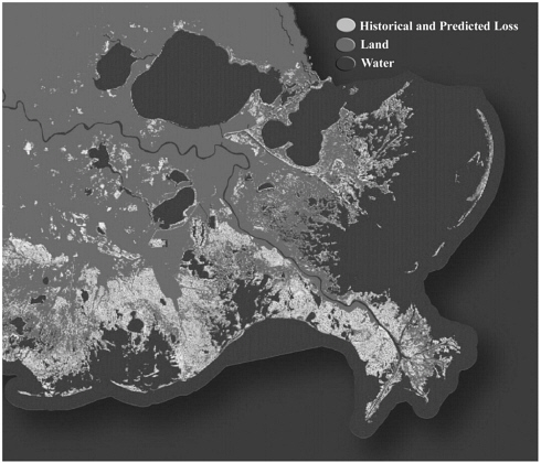
FIGURE 4-1 Historical loss depicted in this image includes data from 1932 to 2000, and projected loss is based projected trends from 2000 to 2050. Data from Barras et al. (2003); available [on-line] at http://www.coast2050.gov/images/landloss8X11.pdf. Figure courtesy of John Barras, U.S. Geological Survey, National Wetlands Research Center, Baton Rouge, Louisiana.
state government and five federal entities—the U.S. Departments of Army, Agriculture, Commerce, and Interior and the U.S. Environmental Protection Agency—to implement wetland restoration projects with approximately $40 million per year of dedicated federal funds. The Corps chairs the Louisiana Coastal Wetlands Conservation and Restoration Task Force created by the Breaux Act. In 1993, the task force, as mandated by Congress, produced a multi-volume Coastal Restoration Plan that proposed numerous projects of varying scales. In addition, a total of 137 projects were authorized for Breaux Act funding. These relatively small-scale projects were estimated to preserve more than 100,000 acres of marsh over their 20-year project life.
To date, 52 projects have been built and are being monitored by the state with the advice of an academic team.
In 1996, it became apparent to the task force that the Breaux Act restoration projects and the two freshwater diversions would prevent only 22 percent of the projected future wetland loss. Under Corps leadership, the task force initiated the “Coast 2050” study and produced a report that presented restoration strategies across the coast and a general implementation plan (Coastal Wetlands Conservation and Restoration Task Force, 1998). The Coast 2050 plan was revised and updated and renamed the Louisiana Comprehensive Coastwide Ecosystem Restoration (LCA) Study. The State of Louisiana is the local sponsor of the feasibility study. For purposes of the feasibility study, the Louisiana coast was divided into four coastal regions that were further subdivided into nine coastal Louisiana hydrologic units. Priority of study in each region is determined, in part, by the rate of wetland loss within each coastal unit.
To guide the development of the LCA feasibility study, the Corps’ New Orleans District has formed a collocated team of federal and state environmental scientists and engineers, which is housed full- or part-time at the district. The collocated team consists of 15 team members representing six federal and state agencies. The expertise of team members includes marsh ecology, fish and wildlife biology, water quality, desktop modeling, and hydrology. These team members are involved in the preparation of the endangered species assessment, the coastal zone consistency determination, and the essential fish habitat reports that must accompany the feasibility study. Hence, members of the collocated team are involved in reducing the potential conflicts among regulatory agencies as individual projects are planned and constructed.
A National Technical Review Committee of outside experts is responsible for reviewing the LCA study plan throughout its development. A portion of the funding allocated by the Corps and the state for the feasibility study has been transferred to academic institutions for modeling support. The local academic community has also been involved with the interagency team in the development of desktop and numerical modeling efforts. Ecological and hydrological simulation models will be used to formulate projects and to analyze alternatives. A monitoring plan will be developed for each project proposed in the LCA plan, which should enhance the potential for adaptive management and allow course corrections as projects are built and operated.
Integrated Planning and Sediment Management
Another example of the Corps’ use of integrated planning in coastal systems and river basins can be seen in some of its sediment management practices. Because of the regional nature of water and sediment problems, the Corps has developed an integrated research and demonstration effort called the Regional Sediment Management Program (RSMP). The overall goal of the RSMP is “to ensure that water resources projects throughout a sediment region affect sediment, and are affected by it, in an economically and environmentally sustainable manner. It recognizes that the region and embedded ecosystems respond beyond the space and time scales of individual projects, and that a proactive regional planning and engineering approach can produce significant national benefits” (U.S. Army Corps of Engineers, 2002d). This program represents a significant investment by the Corps in developing and demonstrating tools and knowledge in order to manage sediment resources on a regional basis. The program was initially developed with a coastal focus and had demonstration projects in several districts (Mobile, Jacksonville, Philadelphia, New York, and Detroit), and in the South Pacific Division. The need for system planning is particularly evident in cases where river control works have interrupted the delivery of sediment to the coastal zone (see case study below on the California master plan for coastal sediment management). These reductions in coastal sediment supply, which can arise from channel stabilization and sedimentation in reservoirs and detention facilities, can lead directly to accelerated coastal erosion. Jurisdictional boundaries and administrative divisions within the Corps can work against a coordinated effort to develop a efficient regional solution, making integrated planning essential. The RSMP is now being expanded to include inland watersheds.
Case Study: California Master Plan for Coastal Sediment Management. California beaches not only represent an ideal for the state and the nation, but also provide protection of critical habitat and infrastructure, and generate recreation and tourism revenue measured in billions of dollars. Much of California’s coast is actively eroding (Nichols, 2003), and an essential factor driving that erosion is a reduction of sand supply from coastal watersheds. Dams, debris basins, urban land cover, and river stabilization projects all contribute to a reduction in the supply of sediment to the coastline. Sustainable solutions to beach erosion problems are not found through shoreline protection or beach renourishment on a local scale,
but require a regional approach that links sediment sources and pathways to beach erosion and deposition.
Recognizing the regional nature of California’s beach erosion problem, a collaboration of federal, state, and local agencies, led by the Corps and the California Resources Agency, are developing the California Coastal Sediment Management Master Plan (California master plan) to evaluate California’s coastal sediment management needs on a regional, system-wide basis. In addition to evaluating and prioritizing coastal sediment management needs, the California master plan is intended to identify approaches for restoring and maintaining coastal wetlands and beaches and to coordinate information on sediment sources and sinks and beach erosion. As part of this effort, in 1999, the Corps and the California Resources Agency initiated the California Coastal Sediment Management Workgroup (CSMW) to provide a working structure for moving beyond site-specific projects and toward regional solutions to beach erosion problems. The CSMW provides a forum for stakeholders, including government agencies, nonprofit organizations, and the public, and serves as a planning and management entity for regional projects.
Under the auspices of the RSMP, the Corps has located a demonstration program within its South Pacific Division to support development of the California master plan; to develop a statewide approach for solving the sediment problems of shorelines, coastal wetlands, and coastal watersheds; and to quantify regional sediment budgets on a statewide basis.
Integrated Planning and Dredged Material
A related area in which the benefits of system planning have been recognized and supporting authorizations exist concerns the beneficial use of dredged material. Dredged material can be used for beach nourishment or for coastal wetland creation or restoration (see case study on reconstruction of Poplar Island). Although the beneficial use of dredged material is increasing, the proportion of all dredged material used for this purpose is still small, and a number of factors work against consistent attempts to use dredged sediments beneficially. Based on Corps data on federally contracted dredging projects, 7 percent (17.5 million cubic yards) of the nearly 250 million cubic yards of dredged material was used beneficially in 1999. In 2001, the amount of dredged material used beneficially rose to 50 million cubic yards (24 percent) of the nearly 210 million cubic yards dredged. The increase in beneficial use of dredged material indicates that means are being found to support the additional cost
of the beneficial use of dredged material, although the majority of dredged material is not being used for this purpose. Economic incentives are needed to keep the natural resource of dredged material within river and coastal systems so that the material is not lost to the environment permanently.
A dilemma for the Corps and its district offices is that typical dredging projects for navigation channel maintenance are selected on the basis of the least-cost alternative. Although specific authorities exist to allow selection of other alternatives when these alternatives can be shown to provide environmental benefit, short-term financial and scheduling pressures can work against their selection. In most cases, using dredged material beneficially will increase the cost substantially above the least-cost alternative. Because district operation and maintenance (O&M) budgets are sometimes insufficient to cover all the required dredging projects, increased costs associated with beneficial use may come at the expense of delaying other scheduled projects. If districts are proactive, however, they can request beneficial-use funds that are available in the current WRDA. However, the funds designated for beneficial uses in the WRDA are generally much less than what is needed, and some districts may not even apply for these funds because the chances of success are poor.
Districts face a similar dilemma in developing feeder berms that leave clean sand in the coastal environment or pumping sand to a confined disposal facility for storage. These options for managing dredged material are typically more costly than the least-cost alternative. The funds for such projects must come from current O&M funds, from Section 204 or Section 207 authorizations of the WRDA, or from a local sponsor. The least-cost alternative will continue to be attractive to project managers unless some incentive is provided to pursue beneficial-use alternatives. For example, when beneficial use of dredged material delays other projects, the district’s budget in subsequent years could be increased by the amount equal to that spent on the beneficial use in order to complete the delayed projects. Another alternative would be to assess fees associated with channel deepening and maintenance and then use a portion of these fees to fund beneficial-use projects and thereby create greater incentive to undertake such projects.
Recommendation 4-4: Dredged material should be viewed as a natural resource and efforts should be directed at conserving this resource. A system is needed to determine the best use of the dredged material, rather than the least-cost alternative for its disposal. Sufficient funds and incentives should be provided through Sections 204 and 207 of
WRDA, by local sponsors, or by using innovative methods to further increase the beneficial use of dredged material.
Case Study: Reconstruction of Poplar Island. Poplar Island refers to a group of small islands that were originally a single island, located in the upper middle of the Chesapeake Bay. To reconstruct the island to its 1847 size, the Poplar Island Project uses dredged material from the Baltimore Harbor and Channels federal navigation project (Figure 4-2). The project allows for the disposal of a portion of the spoil from extensive maintenance dredging and shipping channel improvements and is expected to generate as much as 100 million cubic yards of dredged material over the next 20 years (U.S. Army Corps of Engineers, 2002e). The project was approved under Section 204 of the WRDA 1992 (P.L. 102-580), and funding was authorized under the WRDA of 1996 (P.L. 104-303). The goals of the project are to optimize the volumetric capacity of the site for dredged material, restore Poplar Island to its 1847 footprint, and create and restore habitat (Headland et al., 2000). The original project cost of $427 million has been reduced to $340 million because the amount of dredged material stored has been reduced from 38 million or 40 million cubic yards to 33 million cubic yards.
The plan is to use clean sediments dredged from the Chesapeake Bay navigation channels to create approximately 1,110 acres of wetland and upland habitats consisting of 111 acres of high marsh, 444 acres of low marsh, and 555 acres of upland habitat. The project is expected to restore the island, create wildlife habitat, and enhance the Chesapeake Bay through increased habitat diversity. The total project life is estimated at 24 years, with the placement of approximately 2 million cubic yards of dredged material per year.
Dikes for containing the dredged material were constructed in two phases. Phase 1 covered approximately 640 acres and included the construction of 25,000 feet of armored perimeter dike, more than 11,000 feet of unarmored interior dike, and a breakwater more than 2400 feet long. Placement of dredged material inside the diked area began in the summer of 2000. Phase II began in 2001 and included the construction of 15,000 feet of armored perimeter dike and approximately 8,000 feet of unarmored interior dike, and this phase covered about 470 acres. As the approximately 2 million cubic yards of dredged material is placed within the containment dikes each year, the elevation is expected to rise to the design elevation of 20 feet above mean low water. The deposited material will then be shaped to provide approximately 80 percent low marsh and 20 percent high marsh,
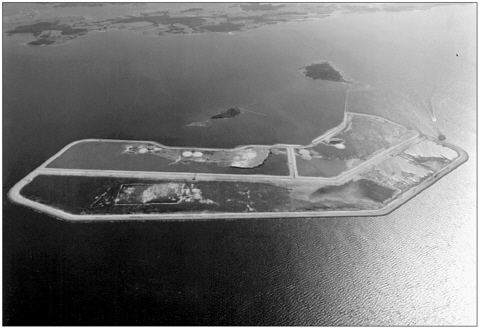
FIGURE 4-2 Poplar Island Environmental Restoration site located in mid-Chesapeake Bay. Photo courtesy of Scott Johnson, U.S. Army Corps of Engineers, Baltimore, Maryland.
with small upland islands, ponds, and channels to increase habitat diversity. Planned by the Corps in collaboration the U.S. Fish and Wildlife Service, the Maryland Department of Natural Resources, and other resource management agencies, the completed project is identified as valuable nesting and nursery area for many species of wildlife, including eagles, osprey, heron, and egret, and it will help to address the historical loss and degradation of this habitat in the Chesapeake Bay.
BARRIERS TO IMPLEMENTATION AND FACTORS FOR FUTURE SUCCESS
The most important factor determining whether an integrated watershed, coastal system, or ecosystem study is completed is the existence of a specific authority for the study and its associated funding. Specific authorization may be developed in response to a disaster such as a flood, to findings of jeopardy under the Endangered Species Act (particularly for
anadromous fish; P.L. 93-205), or to significant degradation of a widely valued ecosystem resource (such as the Chesapeake Bay or the Florida Everglades). In other circumstances, authorization may be developed in response to local or state pressures that prompt congressional interest. Although programmatic authorities exist to support integrated systems studies, these studies have not historically had sufficient funding to allow widespread implementation. Further, such efforts have required special initiative on the part of project managers. In some cases, project managers’ enthusiasm and resource-fulness allow them to take advantage of existing programmatic authority. In other cases, a lack of expertise, enthusiasm, or funding; competing pressures from local sponsors; or turnover in key personnel will act to prevent an integrated watershed or coastal system plan.
Many examples of integrated planning efforts have high stakes, leading to a focused and highly visible attempt to identify the salient issues, incorporate input from all relevant stakeholders, and balance competing objectives. Many Corps water projects have lower visibility. The panel sought to develop some indication of the extent to which ordinary water projects incorporate integrated systems planning. Although the panel received a range of comments regarding integrated systems planning efforts at the district level, these comments were—in the absence of a thorough audit beyond the scope of the panel’s available resources—largely anecdotal. Thus, it was difficult to judge the proportion of Corps projects that effectively incorporate watershed or coastal system evaluations in their planning. Indeed, it was hard to even judge the proportion of Corps projects that claim to account for watershed or coastal system factors. Such studies may appear in different portions of the Corps’ budget (e.g., general investigations, O&M, construction). Some projects may incorporate a significant systems component but have a title that provides no indication of this. Other projects may be titled as, for example, ecosystem restoration projects but may actually include only modest efforts in that regard. Thus, it is not possible to conclusively demonstrate the extent to which adequate systems analysis is carried out to support Corps projects.
A Corps study of the use of watershed planning analyzed 10 environmental restoration and flood damage reduction projects dated 1999-2001. Hansen and Fischenich (2002) developed a list of topics indicative of a watershed perspective in a planning study and evaluated whether or not these items were discussed in the planning documents. They found that the planning studies did a very good job in areas that have long been part of the Corps’ planning methodology, such as characterizing existing conditions, formulating the problem, identifying alternative approaches, and evaluating social benefits and costs. Less consistency was found in evaluating hy-
draulics, hydrology, and sedimentation at the watershed scale; in defining cause-effect relations between physical and biological components of the watershed; and in incorporating adequate adaptive management plans. These are elements that focus on interactions that operate at broader scales than the immediate project area and, therefore, are a central part of integrated water resources planning within river basins and coastal systems.
Some of the most visible integrated water resource projects have a large spatial scale, address significant economic and environmental issues, and have a high regional and national profile. As for any large-scale water project with important environmental consequences and a range of stakeholders with conflicting interests, the quality or adequacy of the Corps’ systems-level planning efforts has been debated in each of these cases. The varied, overlapping, and conflicting objectives in such projects prevent a final project plan that will fully satisfy all parties. In this context, the criteria for success include not just a balance of economic and environmental benefits that satisfies all interested parties, but also a broad-based effort to openly consider all significant issues, applying the best available science and engineering to develop objective information to support the policy choices to be made. The panel was able to find many examples of the Corps’ success in the latter regard.
It is evident to this panel that the Corps, when given the authority and funding, is capable of multi-stakeholder, multi-objective planning projects that incorporate a diverse range of economic and environmental issues over the necessary spatial and temporal scales. Although it was not possible to prepare a “report card” quantitatively on the Corps’ performance in using integrated water resources planning, it was nonetheless evident that its application was less consistent than desired and that particular deficiencies and barriers exist that, if addressed, would allow the Corps to perform more consistently and effectively.


