
8
Economies, Societies, and Landscapes in Transition: Examples from the Pearl River Delta, China, and the Red River Delta, Vietnam
Karen C. Seto
This chapter describes work that links multiple data sources and research perspectives to advance understanding of the dynamics and human causes of land use change, particularly urban growth, in the Pearl River Delta of southern China and the Red River Delta of northern Vietnam. Thus far, the research effort has concentrated on three interrelated questions:
-
How has land cover and land use changed over the last 20 to 30 years in both of these regions? What are the spatial dynamics of these changes and over what time scales do they occur?
-
What are the major human causes of the observed land cover changes? How does the transition from a centrally planned to a market-oriented economy affect land use? What are the broader social, political, and economic factors at the macro level that influence local land use decisions?
-
What are the environmental consequences of changes in the land system? How will land use change affect biophysical properties and biogeochemical cycles?
The chapter includes discussions of completed and ongoing research in the context of theoretical frameworks, methods used, and lessons learned, including a description of the two study regions; the history of the projects; the assembly and processing of remote sensing, spatial, field, and survey data; and conceptual and methodological challenges in implementing the research.
A TALE OF TWO DELTAS
In 1979, China embarked on an ambitious plan to reform its economy. These liberalization policies spurred remarkable rates of economic development and transformed the social, economic, and environmental landscape of the country. Less than one decade later, Vietnam followed suit and implemented nearly identical policies in 1986. The legacy of central planning in China and Vietnam has generated land use patterns that differ significantly from those in market economies (Scarpaci, 2000; Lin, 2002; Tammaru, 2002). Our projects focus on land dynamics in two coastal deltas that share similar geography, climate, ecology, political history, and policy changes.
Pearl River Delta, China
Over the last two decades, China has been experiencing an urban revolution that is likely to continue through the first half of the twenty-first century. Currently, one-quarter of the 500 largest urban areas in the world are in China, and the country’s urban population is predicted to increase to nearly 900 million by 2030 (United Nations, 2002). In China, the Pearl River (Zhujiang) Delta in the southern province of Guangdong is one of the most economically vibrant regions; it is also where urban growth and land conversion are the most dramatic (Plate 6). The Pearl River Delta is an area of approximately 26,000 square kilometers (km2). Crossed by the Tropic of Cancer, it has a long agricultural history with fertile alluvial soils that can support two to three crops per year.
From 1980 to 2000, the average real rate of increase in gross domestic product for the delta was greater than 16 percent, and the economy expanded more than eleven-fold (Statistical Bureau of Guangdong, 2002 [various years]). High rates of economic and urban growth in the region have their origins in 1979, when the central government promulgated decentralization policies and market reforms. The most significant of these reforms included (1) abolition of collective farming in favor of the “household responsibility system,” which introduced subcontracting and allowed communes to divide their land among farmers; (2) agricultural price reforms that eliminated output quotas and permitted farmers to sell their product at market prices; (3) relaxation of hukou, China’s stringent household registration system, which limited people’s residential mobility; (4) diminished importance of danwei, the work unit that provides basic goods and social services, such as housing, health care, food ration tickets, and education; (5) establishment of special economic zones and policies to attract foreign direct investments; (6) decentralization of fiscal policy, which allowed the provincial and regional governments more autonomy to create their devel-
opment priorities and issue loans; (7) transfer of state-owned enterprises from the central to the provincial government; (8) land tenure reform that allows transfers of land use rights; and (9) establishment of land markets that permits purchase of land through bid or auction (Table 8-1).
Before the reforms, migration from rural to urban areas was tightly controlled by the state. Together, the hukou and danwei limited geographic mobility and curbed urbanization. Social reforms and gains in agricultural efficiency have led to an increase in the number of “floating” or temporary workers. Since the reforms, migration has been a growing component of population growth in the delta and the province as a whole. In 1995, nearly 13 percent of all temporary migrants in China were located in Guangdong Province (Liang, 2001). In 1998, the official population estimate for the Pearl River Delta was 29 million (Statistical Bureau of Guangdong, 2002), up from 8 million in 1970 (Indian National Science Academy, Chinese Academy of Sciences, and U.S. National Academy of Sciences, 2001). Unofficial estimates of the floating population in the delta range from 10 million in 1997 (Shen, 2002) to 20 million in 2003.
Red River Delta, Vietnam
Similar economic, social, and political transitions are under way in Vietnam. In 1986, the Vietnamese government promulgated the doi moi (renovation) reforms to increase national productivity, stimulate foreign direct investment, and modernize the country’s infrastructure. The most salient components the reforms were (1) abolition of collective farming; (2) agricultural price reforms; (3) establishment of industrial zones, export processing zones, and high-tech zones; (4) policies to attract foreign direct investment and official development assistance; (5) decentralization of fiscal policy; (6) promotion of small and medium enterprises; (7) land tenure reform; and (8) establishment of land markets (Table 8-1).
One of the major successes of the doi moi is that Vietnam shifted from being a rice importer in the 1980s to the world’s third largest exporter of rice in the late 1990s, and since 1986, the gross domestic product has grown on average 7 percent per year (General Statistical Office, 2001, 2003 [various years]). The reforms have also led to an increase in rural-urban migration, agricultural expansion and intensification, a focus on export cash crops, urban expansion, and coastal land conversion. Although the size of the urban population is still relatively small at 19 million in 2000 (24 percent of total population), it is expected that the country will urbanize rapidly over the next three decades, with estimates of the urban population reaching 45 million, or 41 percent of total population, by 2030 (United Nations, 2002).
Our study area in Vietnam is the Red River (Song Hong) Delta, located
TABLE 8-1 Policy Reforms in China and Vietnam
|
China |
Vietnam |
||
|
Sector |
Policy |
Sector |
Policy |
|
Agriculture |
Eliminated collective farming, agricultural price reforms |
Agriculture |
Eliminated collective farming, agricultural price reforms |
|
Land use |
Established private land use rights and land markets |
Land use |
Established private land use rights and land markets |
|
Decentralization |
Gave lower level governments more autonomy from central government |
Decentralization |
Gave lower level governments more autonomy from central government |
|
Foreign investments |
Provided incentives to foreign entities |
Official development assistance |
Provided incentives to foreign entities |
|
Special economic zones |
Encouraged foreign investments and export economies |
Export, industrial, and high-tech zones |
Encouraged foreign investments and export economies |
|
Town and village enterprises |
Evolved agriculture collectives into industrial units |
Small and medium enterprises |
Promoted small-scale industries |
|
Population mobility |
Relaxed the household registration system and reduced importance of the work unit |
|
|
in the northeast (Plate 7) with a population of 17 million in 2000, 80 percent of whom live in farming communities (General Statistical Office, 2001). Shaped like an inverted triangle covering 16,000 km2, the Red River Delta is often called the “cradle of the Vietnamese civilization.” It is one of the country’s two major agricultural regions, and produces nearly 40 percent of the country’s total output of rice (General Statistical Office, 2003). Yet despite its agrarian landscape, the Red River Delta is a region responding to multiple stressors and undergoing numerous socioeconomic and environmental transitions. With the end of the U.S. trade embargo in 1994, normalization of relations with the United States in 1995, and an increase in foreign trade, the central government has focused on a multifaceted export economy: one track gears Vietnam to be the largest rice exporter in the world, another track directs the country toward high-value, export-
oriented commodities, such as farmed shrimp. In less than a decade, large coastal sections of the Red River Delta have been converted to shrimp aquaculture ponds, transforming wetlands and societies.
Given the agricultural and economic importance of the Red River and Pearl River deltas, the social and political dynamics of transition economies, and the potential for each region to be held up as success cases and duplicated throughout their respective countries, the two deltas were chosen as our study sites to evaluate human–environment interactions. Both deltas are particularly rich areas in which to monitor and measure land use dynamics, understand the factors that drive land use change, and evaluate the social and ecological impacts of these changes. The strength of this comparative framework lies in similar prereform conditions and policy reforms in both countries, as well as the ability to identify common interrelationships among population, land use, and environment across geographic settings. Clearly, there are differences between the two regions, but the shared similarities allow for isolation of distinguishing features and policies related to land use, as well as to identify higher level generalities beyond an individual case study. Although there exist numerous studies of land use dynamics, to date there are few comparative studies across regions and countries. The comparative studies that do exist tend to be either intracountry (Schweik, Adhikari, and Pandit, 1997; Liu et al., 2003) or conducted with different teams of researchers in disparate political, cultural, and geographic settings (Indian National Science Academy, Chinese Academy of Sciences, and U.S. National Academy of Sciences, 2001).
CONCEPTS, DATA, AND METHODS
Our project has two overarching questions: What are the land use impacts of rapid economic growth that occurs after the restructuring of an economy? How generalizable are these dynamics across similar—yet different—contexts?
Conceptualizing Population, Land Use, and Environment
Our conceptualization of the relationship among population, land use, and environment builds on the perspective that social, cultural, and institutional factors play mediating roles (Turner and Meyer, 1991; National Research Council, 1992). Population growth and changes in lifestyle, consumption, institutions, and industrialization all contribute to land use change in China and Vietnam, although each factor’s relative impact is unclear (Heilig, 1997). It has been argued that institutions, such as the state play a larger role in land use change than other factors in China (Song and Timberlake, 1996). While the government can direct the spatial structuring
of foreign and domestic capital investments, thereby affecting the pattern of land use (Sit and Yang, 1997), we hypothesize that land use change is primarily driven by foreign interests in the form of investments and development assistance aid. In both countries, the combination of regional differences in economic opportunities between coastal and interior provinces and reforms have contributed to large intracountry migration and a significant floating labor population (Liang, 2001). Population migration is not the underlying cause of land use change, but rather is the effect of economic opportunities made available by investments by foreign firms and governments. As such, the interrelationship among population, land use, and environment is conceptualized as a “two-by-two” framework that operates in two scales and in two phases.
In the first phase, land use change is driven by investments by foreign interests (e.g., foreign direct investment, official development assistance). These investments usually concentrate on construction, transportation, and export industries. Investments for roads and construction are financially substantial, and they also drive large-scale and wholesale land use change, which occurs in short time periods. For example, a new residential development zone can be constructed in one year and pave over all farmland in a village. In the second phase, land use change is driven by domestic forces: population migration, regional differences in economic opportunities, property rights, and political factors. These land use changes occur over longer time intervals and are smaller in scale. For example, coastal mangrove conversion in Vietnam has occurred over a 10-year period and is undertaken largely by households. Hence, we hypothesize that land use change largely depends on political institutions and their effectiveness in attracting local versus foreign investments, as well as the manner in which these industries drive population movements.
Prior research suggests that locally based firms result in different scales and patterns of urban land use change than foreign investment (Sit and Yang, 1997). Concentrated manufacturing feeding on large local labor forces, for example, may lead to a more desakota-style expansion, one that involves an intense mixture of agriculture, cottage industry, residential development, and industrial zones (McGee, 1991). Regardless of ownership, the scale and kind of industries (capital-intensive versus labor-intensive) will lead to different types of land conversion. Similarly, investments based on local labor supplies will produce very different patterns of urban land use change than development that draws much of its labor through in-migration. Furthermore, urban development can spur additional in-migration and attract higher levels of investment.
Scale of Analysis
One motivation for our research is to develop an understanding of how policy levers can be used to affect land use outcomes. As with most countries, decision making regarding land use in the Pearl River Delta and the Red River Delta occurs at multiple scales. Before the reforms, land use decision making in China was done at the central state level, with local governments facilitating individual transactions. Central control over land management and urban planning ended with the Land Administrative Law in 1986, which gave ownership of rural land to the collective organization of farmers and the amendment of the constitution in 1988, which allowed transfers of land use rights. The Land Administration Law permitted a hierarchical approval system of land use transformation, in which lower administrative levels, such as rural townships and counties, were allowed to transfer smaller parcels of land than higher levels of administration such as the central state or provinces. With multiple levels of government, all part of “the State,” the Land Administrative Law encouraged a mélange of individual municipal-level development plans, uncoordinated land transfers, and rapid land use change. This allowed cities and counties to develop their own policies and incentives to encourage investment and development.1 Political and economic independence to sanction urban development at lower administrative levels ceased when the Land Administrative Law was amended in 1999 and local governments were no longer allowed to make decisions on land use change (Cartier, 2001). Recognizing that land use planning occurs at various administrative levels, our choice in selecting the county as the unit of analysis is predicated in part by the availability of rich and consistent socioeconomic data at this level.
In the Red River Delta, our analysis is conducted at two scales, the province and the household. There are several reasons for multiscale analysis. One reason is that we evaluate two types of land dynamics: the conversion of agricultural land to urban uses and the conversion of mangroves and rice paddy farms to aquaculture. The decision-making process behind urban land conversion is similar to that in the Pearl River Delta, where multiple administrative levels, but not farmers, are involved with regional and urban planning. Therefore, in order to facilitate cross-study comparisons, in the Red River Delta we chose the province, a spatial and decision-
making unit that is comparable to the county in the Pearl River Delta. In terms of coastal land use change and aquaculture development, decision making also occurs at multiple administrative units. For example, farmers who want to convert rice fields to other uses must first receive approvals from commune officials, who submit an application to the provincial government to seek permission to take farmland out of agricultural production for aquaculture. However, once this application is approved, the decision to switch to aquaculture is a household choice and the decision maker is the farmer. Consequently for questions relating to urban expansion, we analyze the data at the provincial level. For questions relating to aquaculture development, our unit of analysis is the household.
Landscapes in Transition
Urban growth in the Pearl River Delta has been and continues to be a highly dynamic process. Although Rome was not built in a day, cities in the Pearl River Delta are—or nearly. New cities, industrial zones, and high-tech centers spring up across the countryside in a matter of months. Entire farming villages and vast tracts of agricultural land become the drawing board for master-planned communities and shopping malls. Due to the high degree of land conversion in the region, it was important to obtain a high-frequency time series of satellite data to capture land system dynamics. Most land use change studies evaluate satellite data at three or four points in time, but this would not capture the rapidly changing land processes in the Pearl River Delta. With this in mind, we developed a Landsat Thematic Mapper (TM) data set of 19 images of the Pearl River Delta, representing the period 1973-2001. We subdivided the data set into two periods, pre-and postreform, and analyzed each set separately. During the first phase of the project, we analyzed 9 TM images acquired annually over the period 1988-1996. Collecting these data took much longer than expected due to unforeseen obstacles in obtaining an accurate inventory of cloud-free images.
After acquisition of the imagery, our next challenge was to develop methods to radiometrically calibrate the data and evaluate land use change. What began as a simple question about the most appropriate method of calibration given our long time series evolved into a lengthy, but invaluable, comparison of techniques that provide guidance on appropriate atmospheric correction for change detection studies (Song et al., 2001).
With some exceptions, most existing change detection methodologies have been developed for two images. The aim of many of these methods is to accurately identify land cover change, not necessarily to develop a land change data set with desirable statistical characteristics (e.g., unbiased). Yet in order to couple remote sensing data with population and economic data
for statistical modeling, the remote sensing estimates must be both accurate and unbiased. Using econometric techniques, we developed a methodology that generates such a data set (Kaufmann and Seto, 2001). The value of new methodologies based on time-series techniques will increase as the Landsat database continues to expand and as opportunities arise to compare more images through time. We also explored the utility of classification and change detection methods based on logit models and artificial neural networks to identify urbanization (Kaufmann and Seto, 2001; Seto and Liu, 2003; Seto and Kaufmann, 2005).
Several of the approaches undertaken by other studies in this volume have similar goals of identifying the life cycle or land use path of a pixel or an area beyond two or three points in time. The method employed by Central Arizona–Phoenix Long-Term Ecological Research study, to develop trajectories for neighborhoods using satellite and historical data (Chapter 7), and the approach taken by the Nang Rong study, to follow a classified pixel through a series of images (Chapter 6), are both attempts to resolve the issue of capturing the land dynamics of a region and could be applied to our case studies. Other new and promising image-processing methods for evaluating land use change include subpixel classification approaches (Haertel, Shimabukuro, and Almeida, 2004; Yang et al., 2003), the incorporation of very high resolution data from sensors such as IKONOS and Quickbird (Goward et al., 2003; Hurtt et al., 2003), spatiotemporal modeling using geostatistics (Boucher, Seto, and Journel, no date; Melgani and Serpico, 2003), and data fusion techniques (Le Hegarat-Mascle and Seltz, 2004).
Our remote sensing analyses in the Pearl River Delta showed that urban expansion in the postreform period occurred largely at the expense of productive farmland (Seto et al., 2002), and that the rate of this land conversion is much higher than officially reported (Seto, Kaufmann, and Woodcock, 2000) (Figure 8-1). Urban areas increased by more than 300 percent during the 1988-1996 period, from 720 to 2,625 km2. Although this is not completely surprising given the rate of economic development, the rates of land transformation are nonetheless impressive. The widespread conversion of agricultural land to urban areas in China is not limited to the Pearl River Delta. Similar patterns of land use change have been documented throughout the country, including the Yangtze Delta (Liu et al., 2003), Beijing (Qi et al., 2004), and greater Chengdu (Schneider, Seto, and Webster, in press). In recent years, many Chinese institutions have used multitemporal Landsat data to complete country-scale studies on the status of agricultural land and urban growth (Liu et al., 2003; Young and Wang, 2001). Our work contributes directly to this body of knowledge by comparing the official rates of agricultural land loss to satellite estimates and linking policy with land use change.
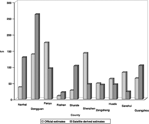
FIGURE 8-1 Agricultural land loss for selected Pearl River Delta counties, 1990-1996.
SOURCE: Seto, Kaufmann, and Woodcock (2000).
One notable unexpected finding is the extent to which waters in the delta are being reclaimed for agriculture to offset the loss of farmland elsewhere in the region. The reclamation of coastal waters and wetlands for agriculture has been a common practice in China for decades. However, the scale of the current reclamation projects was unexpected. We are currently working on evaluating the effects of urban growth patterns on local climate and conducting comparable studies in western China (Schneider et al., 2003, in press).
For our study in the Red River Delta, the remote sensing data and processing methods have proven to be more complex than for the Pearl River Delta. The Pearl River Delta as defined by our study lies completely within one Landsat scene (WRS 122-44). However, the Red River Delta spans a mosaic of 4 scenes (WRS 126-45, 126-46, 127-45, 127-46). Despite our best efforts to develop a cross-path calibration technique that allows the four scenes to be processed simultaneously, we were unable to
achieve satisfactory results. We have had to analyze each scene individually—an inefficient method and not practical for regional-scale studies. Because the land transitions in the Red River Delta are not dominated by urbanization and involve other changes (e.g., coastal aquaculture development), we have looked at different remote sensing techniques for different landscapes. For example, the dramatic changes on the coast (Seto et al., no date) are best identified with algorithms different from those used to map urbanization around Hanoi (Seto and Nguyen, 2002; Duong et al., 2003).
We found that aquaculture is expanding rapidly throughout the delta, with an increase of more than 30 km2 over 15 years. Shrimp aquaculture was introduced to the Red River Delta in the early 1980s. After the introduction of doi moi, nearly all the mature mangroves—approximately 20 km2—were cleared for shrimp production (personal communication, Xuan Thuy Ramsar Office; Seto et al., no date). The Red River Delta is home to the last significant remnant of mangrove and mudflat habitat on the Vietnam coast and the only wetland in the country on the Ramsar List of Wetlands of International Importance.
Other land system changes under way in the Red River Delta are more difficult to assess with remote sensing. Concurrent with urban and aquaculture expansion is the intensification of farming methods. To meet the goal of making Vietnam the world’s number one rice exporter, the central government is making widely available agricultural price supports, micro-financing and farm credit, and input subsidies. The net result is an increase in yields (Figure 8-2) but also increasing fertilizer and pesticide applications. Other farming practices also have changed. Crop types are more for market and export than for family and local consumption, crop rotation cycles have shortened, and water management—especially midseason drainage—is a common practice to increase yields. The spread of fish, shrimp, and crab aquaculture has replaced the wet-season rice–dry-season fish system. One effect of dry-season irrigation pumping for aquaculture ponds is that saltwater intrusion is increasingly a problem.
Economies and Societies in Transition, Drivers of Land Use Change
We combined the remote sensing estimates of land use change with county-level demographic and economic data obtained from the Guangdong Statistical Yearbooks to develop land use models of the region. Examples of socioeconomic variables include agricultural population; urban population; the number of town or village enterprises; output of grain; gross output value of agriculture; gross output value of industry; output in primary sector, which comprises mainly agriculture (farming, forestry, animal husbandry, and aquaculture); output in the secondary sector, which is mainly industry; and output in tertiary sector, which includes all industries not
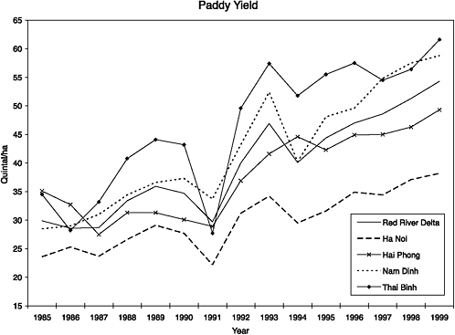
FIGURE 8-2 Paddy yield for select provinces in the Red River Delta, Vietnam.
included in the agriculture or industrial sectors. Field interviews with farmers and target meetings with city planners and key decision makers provided a historical narrative and filled information gaps about the urban land conversion process.
The temporal sample used for the model spanned nine years, and land use change estimates spanned eight years. Both sample sizes are too small to allow models to be developed for individual counties in a statistically meaningful manner. Instead, the land use change and socioeconomic data were pooled to form a set of panel data that includes 8 years of observations for 12 counties. One reason for pooling the data in this manner is that panel econometric techniques allow account and control for heterogeneity across samples and the ability to develop more complex models; the increase in data points results in more degrees of freedom and hence reduces multicollinearity, provides gains in statistical efficiency, and reduces problems with omitted variable bias.
We used fixed and random coefficient models to estimate the rates of land use change from natural ecosystems to urban and from farmland to urban in the Pearl River Delta. The results indicate that the annual rate at which agricultural land is converted to urban uses is correlated with invest-
ment in capital construction, the productivity of land productivity in agriculture versus urban uses, agricultural labor productivity, and off-farm wage rates (Table 8-2). As expected, the sign on the coefficient associated with investment in capital construction is positive. This is consistent with observations that much of the capital construction in the Pearl River Delta is directed at residential and industrial complexes and new roads. The sign on the coefficient associated with returns to agricultural land relative to industrial uses is also positive. The conversion of agricultural land is negatively related to agricultural labor productivity. This variable is an indicator of agricultural wages. As on-farm income increases, the opportunity cost of converting farmland increases, and farmers are less inclined to convert agricultural land to nonfarm uses. Finally, average off-farm wages have a positive effect on agricultural land conversion.
The annual rate at which forests, shrubs, and water bodies are converted to urban uses is correlated with investment in capital construction, the return to agricultural land relative to industrial uses, and labor productivity in agriculture relative to industry (Table 8-2). Again, investment in capital construction tends to accelerate the rate at which natural ecosystems are converted to urban uses. Despite the similar signs, the interpretation of the relative land productivity variable is different from the agriculture→ urban model. For this model, we interpret relative land productivity as a proxy for the opportunity cost of land conversions. For counties in which
TABLE 8-2 Results from Analysis of Land Use Change in the Pearl River Delta
|
Variable |
Agriculture→Urban |
Natural→Urban |
|
Constant |
–0.109 (–4.95) |
0.028 (3.13) |
|
|
1.496 (1.97) |
6.53 (3.55) |
|
|
|
–1.39 (–3.37) |
|
|
–3.965 (–4.58) |
|
|
|
1.24 (2.74) |
2.85 (3.27) |
|
Low (Average total wage) |
0.032 (5.98) |
|
the productivity of agricultural land is high relative to urban uses, the opportunity cost associated with converting agricultural land is high relative to converting forest and water. This higher opportunity cost tends to favor the conversion of natural ecosystems and, hence, a positive relationship with natural land conversion. Relative labor productivity is defined as the ratio of agricultural labor productivity to industrial labor productivity. If agricultural labor productivity is high relative to industrial labor productivity, there is little incentive to convert natural ecosystems to industrial uses. Rather, higher relative agricultural labor productivity suggests that agricultural land produces greater returns than industrial land. Therefore, there is less incentive to urbanize natural areas. On the contrary, there may be more pressure to convert natural areas to agricultural land to take advantage of the relative high labor productivity.
Our models showed that international investments are one of the primary drivers of urbanization in the Pearl River Delta (Seto and Kaufmann, 2003). Investments from abroad generally fuel large-scale projects, whereas domestic investment sources generally fund small or medium-scale projects. Large projects employ numerous local workers, whose incomes rise as a result. As disposable incomes rise, workers may improve their housing conditions by constructing new homes or refurbishing their existing homes. In many towns, higher incomes increase local demand for shopping arcades, cars, and luxury restaurants. This rise may further provide incentives to build residential and commercial complexes, which are funded by overseas investors. The results suggest that the causes of land use change have multiple feedbacks that include income growth, consumer demand, and population migration. Higher incomes have fuelled a shift from agricultural to nonagricultural livelihoods. Similarly, township and village governments have been agents of urbanization in their levels of jurisdiction by facilitating development of town village enterprises in the region and by endorsing local efforts to cluster privately owned firms through the development of industrial estates and technology corridors. Our results also indicate that local land users do not have much influence over large-scale projects.
Another reason for the conversion of agricultural land to nonagricultural uses is the difference in farm wages versus fees from leases. When farmers can make more money from renting out or leasing their land, there is very little incentive to keep land under cultivation. Poor economic returns to agricultural land could be in part due to the household responsibility system which divided land into plots based on family size and land quality. A single family could have multiple disconnected plots due to differences in land quality and the number of households in a commune. In other words, many households held small parcels of land rather than contiguous property. This fragmentation discourages economies of scale and
prevents some farmers from cultivating cash crops, a practice that requires a larger continuous tract of cropland.
Farmers also have little incentive to make long-term investments or improvements on their land. One of the problems with the household responsibility system is that it does not give farmers land tenure. Farm households have usufruct rights for 30 years and can lease and rent their land, but ownership of the land ultimately belongs to the state. Village leaders and local authorities may occasionally make readjustments to the location and number of parcels each family farms. This has the effect of further reducing incentives for farmers to invest in their land and increasing incentives to seek off-farm work. Officially, land can be acquisitioned by government officials for infrastructure development, such as highways, and farmers should receive compensation for lost farmland. Unofficially, however, local leaders have acquisitioned land from farmers and resold them at higher prices, usually to developers, and farmers have not received compensation.
Our preliminary analysis in Vietnam suggests that urban growth is driven primarily by rural to urban migration and the expansion of existing urban centers rather than by new town development (as was the case in the Pearl River Delta). Large-scale development projects are funded mainly by official development assistance and are limited to the periphery of Hanoi and Haiphong. There is little large-scale conversion of agricultural land outside these two cities. However, periurbanization is accelerating, driven in part by village cottage industries in handicrafts. With official development assistance, the central government is currently developing a modern transportation network that links the three major nodes of the delta (Hanoi, Haiphong, and Nam Dinh). Official development assistance differs from foreign direct investment in that the latter is money invested by a foreign enterprise, whereas official development assistance is essentially foreign aid from official agencies or countries in the form of loans, grants, or technical support. It is expected that the highways will facilitate further urban land conversion.
We conducted structured and semistructured interviews with 56 households distributed across 3 coastal districts to obtain information on household characteristics and aquaculture farm management practices. All but one household responded to the survey. In addition, we conducted interviews with regional planners in Hai Phong and Hanoi and government officials at multiple administrative levels. A majority of farmers began with no experience in shrimp farming. The availability of farm credit and low rice yields were the primary factors that led farmers to try it. Two dominant types of aquaculture farms are prevalent: those constructed in former rice paddies and those constructed in mangrove ecosystems at the mouth of the Red River. The standard of living for some aquaculture farmers has increased in the short run, but this depends on when operations began.
Recent and recurring disease outbreaks, trade barriers, and increased competition by Thai and Chinese shrimp producers have negatively impacted the productivity and profitability of shrimp farming.
Biophysical Impacts of Land Use Change
Urban growth in the Pearl River Delta has affected two key components of the terrestrial carbon cycle, net primary production and the carbon stock. Land use change, and in particular the loss of cropland, caused significant modifications to the regional carbon budget by reducing the annual net primary production and the size of the terrestrial carbon reservoir (Dye, Hinchliffe, and Woodcock, 2000). Analysis of net primary production indicates that terrestrial changes during the study period reduced the amount of annual atmospheric carbon assimilated into phytomass by approximately 1.55 million tons (7.5 percent). More than half of this reduction is due to the conversion of agricultural land. The 7.5 percent decline in annual net primary production is a measure of the reduction in total photosynthetic capacity and carbon sequestration potential of terrestrial ecosystems. The average estimate of annual carbon released due to land use and land cover change is 1.3 × 10⁶ tons Carbon, with a total of 11.7 × 10⁶ tons Carbon for the entire study period. While this is not an insignificant amount, it only represents 8 percent of the emissions from fossil fuels for 1996. Given the region’s land use and development trajectory, it is likely that carbon sources from land use change will continue to be overshadowed by fossil fuel emissions.
Coastal changes in the Red River Delta are likely to affect biogeochemical cycling through increased methane flux from the aquaculture ponds. We combined in situ field measurements, pond management data, and remote sensing and found that all ponds were a source of methane flux, with considerably higher fluxes from the mangrove ponds than the paddy ponds (Seto et al., no date). Our results also indicate that fluxes are positively correlated with the frequency with which the ponds were cleaned as well as the age of the pond.
LESSONS LEARNED AND CHALLENGES AHEAD
We have encountered and learned from a number of challenges through incorporating multiple types of data and disciplinary foci. Specifically, we have come across issues related to integrating conceptual frameworks, data sources and limitations, and methodological challenges. In this section, we discuss each of these issues and our approach to resolving them.
Integrating Conceptual Frameworks
A recurring challenge with most interdisciplinary land use studies is how to integrate different approaches and conceptual frameworks. A related issue is how to identify the appropriate scale of analysis. In our case studies, it has been conceptually—and methodologically—difficult to develop a framework that incorporates bidirectional feedbacks between and among processes. For example, the population–land use relationships in the Pearl River and the Red River deltas operate at multiple scales and are mediated by institutions that also operate at multiple scales, often outside the domestic context. In addition, causality is difficult to assess. Does economic development drive urban growth? A compelling case can be made that urban agglomeration leads to further economic development. What is the role of foreign direct investment? Industrial estates in the Pearl River Delta often recruit workers from other provinces, thereby increasing the number of floating workers. In the Red River Delta, urban development is driven not so much by large-scale foreign direct investment as by official development assistance. Because official development assistance focuses on an economic development project (e.g., road construction) and not an export or manufacturing industry, it usually does not attract temporary workers to a region in the same manner as foreign direct investment. Nonetheless, official development assistance has a role in reshaping the landscape and migration. Developing hypotheses about the relationship among population, foreign assistance, and land use dynamics that can be tested in several contexts is a continuing challenge.
Another challenge is how to identify the decision makers or the agents who make decisions about a parcel of land. It is often assumed that command-and-control economies are characterized by top-down decrees, especially in the urban planning context. However, in reality, urban dynamics have become more the result of a mélange of uncoordinated interests (sometimes at the commune, town, or county level) than the synchronized activities of central government agencies. One challenge of working in these urban environments and, in particular, in transition economies is that land use decision making does not fall under the jurisdiction of the household. The state owns all land and there are multiple and sometimes competing—as in the case of the Pearl River Delta—land use and planning interests. Decisions made by households on how to use the land may be overturned by the state. In the Red River Delta, coastal changes are the exception, in which one of the agents is the household or the commune. Most of the conceptual frameworks developed by the land cover and land use change community pertain to “frontier” environments that are not applicable in urban settings, because the farmers are not the actors converting the land.
We have some understanding of the factors that affect urban land growth, but we need to get a better grasp of institutional processes and the role of social networks in foreign investment and migrant population movements. The actors in this case often are transnational corporations and multinational players, for which there are limited data. We understand the process at one scale, but we have a limited understanding of the larger scale processes, for example, the motivation of firms to locate in these areas. We also have very little insight into the interaction between socioeconomic processes and the pattern of land conversion. In our studies, we have been concerned primarily with the scale and rate of land conversion, and not the spatial patterns of land use change over time. We are now exploring the utility of spatial pattern analysis derived from ecology to understand the temporal and spatial patterns of land use change (Seto and Fragkias, no date), but the challenge will be understand the causal order between the patterns and the processes.
Data Sources and Limitations
Foreign direct investment will play an increasingly larger role in driving urban development in China and throughout Asia. While in frontier environments it is often the farmer or household that converts forests to pasture or agriculture, in urban environments, international capital movements play a significant role. We need better—and spatially explicit—data on domestic and foreign investments to understand patterns and trajectories of economies of agglomeration.
Urban growth in the Pearl River Delta currently occurs at a breathtaking pace, and high temporal resolution satellite and economic data are necessary to capture the temporal and spatial dynamics of change. We have annual satellite and economic data for the Pearl River Delta, but we found that during 1992-1993, the built-up area increased by nearly 700 km2, roughly 10 times the size of Manhattan. Interannual images would have been useful to track the spatiotemporal patterns and track them with political events, such as Premier Deng Xiao Peng’s visit to the region in 1992 and his affirmation that China would continue its open-door policies.
Other authors in this collection (Matson et al., Chapter 10) point to the difficulty of getting social data at appropriate scales. This has been true in our case; the social data have been more difficult to obtain than the biophysical data. Having been command-and-control economies for many decades, the Chinese and Vietnamese governments have much data on household characteristics. However, only county (China) or provincial (Vietnam) data are widely available. Limited town-level data are available in China, but they are only basic demographic indicators, like population. The 2000 census in China offers more spatially explicit data on migration flows, but
the definition of migrant has changed from the 1990 census, limiting across-time comparisons.
As highlighted in the Nang Rong study (Chapter 6), long distance collaboration has its challenges. In our case, the project would not have succeeded without the assistance of Li Xiaowen and Huang Xiuhua at the Institute for Remote Sensing Applications in Beijing and Lu Jinfa the Beijing Institute of Geographical Sciences and Natural Resources Research, all of whom were invaluable for acquiring images, obtaining permission from multiple administrative units to conduct interviews, and organizing fieldwork. For our Chinese collaborators, traveling to the Pearl River Delta from Beijing involved not only traveling 2,000 km, but also other challenges, such as a change in language, as the local dialect in southern China is Cantonese but the national language is Mandarin, and obtaining authorization to enter special economic zones, which requires a special permit.
Methodological Challenges
Land use change tends to be conceptualized in terms of wholesale transformation of the land from one use to another (e.g., agriculture to urban or forest to agriculture). Magnitudinal changes are much more difficult to identify with remote sensing, but intensification of land use in urban environments may be as important as land cover change (e.g., low density urban to dense urban). We have begun to evaluate image processing techniques that can identify changes in the built-up environment (e.g., neural networks), but more work is needed in this area.
We also need better techniques to identify both spatial and temporal patterns of land use change, particularly in urban environments and at the urban-rural interface. Current methodologies assess change using only several satellite images, usually three points in time or fewer. Postclassification change detection remains the most common method to process longer time series, but this method is time-consuming for large data sets and has severe limitations in terms of accuracy. We need to better utilize methods from time-series analysis and apply them to high-resolution image processing. Similarly, more research is required on cross-path calibration. Our single-scene processing of the Red River Delta mosaic is inefficient and costly.
In terms of integrating remote sensing and socioeconomic data, not many remote sensing studies deal with the issue of bias. We carried out accuracy assessments to estimate the accuracy of our maps, but with time-series studies, we also need an estimate of temporal bias. For example, in linking the time series of satellite images with the time series of social data, we attribute land use observed in a particular year to social data (usually there is some lag associated with policy, migration, and land use, but we assume for simplicity there is a one-to-one relationship between land use and demographics). If the
remote sensing analysis systematically biases results to attribute change to an earlier or later date, we have difficulties using these data for statistical models. There is reason to believe that this temporal bias exists because land use studies that rely on remote sensing data have a selection bias due to the availability of cloud-free or available images. The acquisition date of the imagery available may have nothing to do with socioeconomic processes on the ground, but land use change will be attributed to the dates for which images exist. In the study of the Pearl River Delta, our analysis would be quite different if we did not have images over a high temporal frequency, especially for the period before and after 1992.
A related issue is how to redistribute the pixels in space after an accuracy assessment. We have multiple methods for calculating and reporting the accuracy of maps—kappa statistics, contingency tables, etc. Because the maps are not ends in themselves but will be integrated with other data, how will the results of the accuracy assessment be incorporated? That is, do we adjust the map estimates, or do we to deal with the map errors in the integration step? Historically, remote sensing methodologies for land cover mapping aimed at producing maps as final outputs, not as data to be used with other data sets. We need accuracy in terms of space and reallocation of classes or pixels through space. For example, suppose the accuracy for a single map class, forest to urban, is 65 percent. From field-based accuracy assessments, we learn that most of the misclassified pixels should have been classified as agriculture to urban. It is common to readjust area estimates based on the accuracy assessments, but how do we reallocate the misclassified pixels spatially?
Recent developments in spatial statistics, time-series econometrics, and regional science have been applied to land use change models to overcome many conceptual and methodological constraints of the past, including improvements in modeling nonlinear relationships, spatial dependence and contagion, and temporal nonstationarity. Although methods exist that measure and correct for spatial and temporal nonstationarities, they have not been widely adopted in land use modeling. More work is necessary, especially in regard to testing for causality. Methods exist in econometrics, but they have not been widely applied or accepted in land use change studies.
Integrated Land System Science: Challenges and Opportunities
We have attempted to answer questions related to land system dynamics in rapidly changing economic and political environments in the Pearl River and Red River deltas. These case studies are continually evolving as lessons learned in one region are applied to another. The challenge ahead is to develop tools and approaches that can be applied
to both regions. Although the contexts are different, we have found that the conceptual framework used in the Pearl River Delta is largely applicable to the Red River Delta. By undertaking multiple place-based case studies to draw comparisons at different spatial scales and across different political regimes, this project has sought to identify common themes about the interaction of population, institutions, and economics and land use change.
ACKNOWLEDGMENTS
This research has been supported by National Aeronautics and Space Administration Land Cover/Land Use Change Program grant no. NAG5-6214, NASA New Investigator Program grant no. NAG5-10534, and National Science Foundation CAREER Program grant no. BCS-348986. Numerous people across organizations and countries made this work possible. In particular, the author would like to thank Curtis Woodcock and Robert Kaufmann at Boston University, Michael Beman and Michail Fragkias at Stanford University, Lu Jinfa at the Beijing Geography Institute, Huang Xiuhua at the Institute of Remote Sensing Applications in Beijing, and Nguyen Dinh Duong and Dang Xuan Phong at the Vietnam National Centre for Natural Science and Technology.
REFERENCES
Boucher, A., K.C. Seto, and A.G. Journel no date A novel method for mapping land cover changes: Incorporating time and space with geostatistics. Submitted to IEEE Transactions on Geoscience and Remote Sensing.
Cartier, C. 2001 “Zone fever,” the arable land debate, and real estate speculation: China’s evolving land use regime and its geographical contradictions. Journal of Contemporary China 10:445-469.
Duong, N.D., L.K. Thoa, H.T. Hoan, T.A. Tuan, H.L. Thu, and K.C. Seto 2003 A study on the urban growth of Hanoi using multi-temporal and multi-sensor remote sensing data. Asian Journal of Geoinformatics 3(3).
Dye, D.G., T.C. Hinchliffe, and C.E. Woodcock 2000 Modeling the effects of recent land use change on the carbon cycle in the Zhu Jiang Delta region of Southern China. Presented at the 21st Asian Conference on Remote Sensing, December 4-8, Taipei, Taiwan. Available: http://www.gisdevelopment.net/aars/acrs/2000/ts11/glc003.shtml [accessed April 2005].
General Statistical Office 2001 Vietnam Statistical Yearbook. Hanoi, Vietnam: Statistical Publishing House.
2003 Vietnam Statistical Yearbook. Hanoi, Vietnam: Statistical Publishing House.
Goward, S.N., P.E. Davis, D. Fleming, L. Miller, and J.R.Townshend 2003 Empirical comparison of Landsat 7 and IKONOS multispectral measurements for selected earth observation system (EOS) validation sites. Remote Sensing of Environment 88:80-99.
Haertel, V., Y.E. Shimabukuro, and R. Almeida 2004 Fraction images in multitemporal change detection. International Journal of Remote Sensing 25:5473-5489.
Heilig, G.K. 1997 Anthropogenic factors in land use change in China. Population and Development Review 23:139-155.
Hurtt, G., X. Xiao, M. Keller, M. Palace, G.P. Asner, R. Braswell, E.S. Brondizio, M. Cardoso, C.J.R. Carvalho, M.G. Fearson, L. Guild, S. Hagen, S. Hetrick, B. Moore, C. Nobre, J.M. Read, T. Sa, A. Schloss, G. Vourlitis, and A.J. Wickel 2003 IKONOS imagery for the large scale biosphere-atmosphere experiment in Amazonia (LBA). Remote Sensing of Environment 88:111-127.
Indian National Science Academy, Chinese Academy of Sciences, and U.S. National Academy of Sciences 2001 Growing Populations, Changing Landscapes: Studies from India, China and the United States. Washington, DC: National Academy Press.
Kaufmann, R.K., and K.C. Seto 2001 Change detection, accuracy, and bias in a sequential analysis of Landsat imagery in the Pearl River Delta, China: Econometric techniques. Agriculture, Ecosystems and Environment 85:95-105.
Le Hegarat-Mascle, S., and R. Seltz 2004 Automatic change detection by evidential fusion of change indices. Remote Sensing of Environment 91:390-404.
Liang, Z. 2001 The age of migration in China. Population and Development Review 27:499-524.
Lin, G.C.S. 2002 The growth and structural change of Chinese cities: A contextual and geographic analysis. Cities 19:299-316.
Liu, J., M. Liu, D. Zhuang, Z. Zhang, and X. Deng 2003 Study on spatial patterns of land use change in China during 1995-2000. Science in China 46:373-384.
McGee, T.G. 1991 The emergence of desakota regions in Asia: Expanding a hypothesis. Pp. 3-25 in The Extended Metropolis: Settlement Transitions in Asia, N. Ginsburg, B. Koppel, and T.G. McGee, eds. Honolulu, HI: University of Hawaii Press.
Melgani, F., and S.B. Serpico 2003 A Markov random field approach to spatio-temporal contextual image classification. IEEE Transactions on Geoscience and Remote Sensing 41:2478-2487.
National Research Council 1992 Global Environmental Change: Understanding the Human Dimensions. Committee on the Human Dimensions of Global Change, Commission on the Behavioral and Social Sciences and Education, P.C. Stern, O.R. Young, and D. Druckman, eds. Washington, DC: National Academy Press.
Qi, Y., M. Henderson, M. Xu, J. Chen, P.J. Shi, C.Y. He, and G.W. Skinner 2004 Evolving core-periphery interactions in a rapidly expanding urban landscape: The case of Beijing. Landscape Ecology 19:375-388.
Scarpaci, J.L. 2000 On the transformation of socialist cities. Urban Geography 21:659-669.
Schneider, A., K.C. Seto, D. Webster, J. Cai, and B. Luo 2003 Spatial and Temporal Patterns of Urban Development in Chengdu, 1975-2002. Stanford University Asia/Pacific Research Center Discussion Paper.
Schneider, A., K.C. Seto, and D. Webster 1994 Urban growth in Chengdu, Western China: Application of remote sensing to assess planning and policy outcomes. Environment and Planning B: Planning and Design 32(3):323-345.
Schweik, C.M., K. Adhikari, and K.N. Pandit 1997 Land-cover change and forest institutions: A comparison of two sub-basins in the southern Siwalik Hills of Nepal. Mountain Research and Development 17:99-116.
Seto, K.C., and M. Fragkias no date Quantifying Spatial and Temporal Patterns of Urban Land Use Change: A Characterization of Four Cities with Time Series Landscape Metrics. Submitted to Landscape Ecology.
Seto, K.C., and R.K. Kaufmann 2003 Modeling the drivers of urban land use change in the Pearl River Delta, China: Integrating remote sensing with socioeconomic data. Land Economics 79:106-121.
2005 Using logit models to classify land use and land use change from Landsat TM. International Journal of Remote Sensing 26(3):563-577.
Seto, K.C., and W. Liu 2003 Comparing artmap neural network with the maximum likelihood classifier for detecting urban change. Photogrammetric Engineering and Remote Sensing 69:981-990.
Seto, K.C., and D.D. Nguyen 2002 Using a multi-sensor approach to monitoring urban growth in Hanoi: 1973-2001. Proceedings of the International Symposium on Remote Sensing of Urban Areas.
Seto, K.C., R.K. Kaufmann, and C.E. Woodcock 2000 Landsat reveals China’s farmland reserves, but they’re vanishing fast. Nature 406: 121.
Seto, K.C., C.E. Woodcock, C. Song, X. Huang, J. Lu, and R.K. Kaufmann 2002 Monitoring land use change in the Pearl River Delta using Landsat TM. International Journal of Remote Sensing 23:1985-2004.
Seto, K.C., J.M. Beman, W. Liu, M. Fragkias, and P.A. Matson no date Coastal Land Use Change in Northern Vietnam: Aquaculture Development, Mangrove Conversion, and Methane Flux.
Shen, J. 2002 State sponsored and spontaneous urbanisation in the Pearl River Delta of south China, 1980-1998. Urban Geography 23:674-694.
Sit, V.F.S., and C. Yang 1997 Foreign-investment-induced exo-urbanisation in the Pearl River Delta, China. Urban Studies 34:647-677.
Song, C., C.E. Woodcock, K.C. Seto, M. Pax Lenney, and S.A. Macomber 2001 Classification and change detection using Landsat TM data: When and how to correct atmospheric effects? Remote Sensing of Environment 75:230-244.
Song, F.X., and M. Timberlake 1996 Chinese urbanization, state policy, and the world economy. Journal of Urban Affairs 18:285-306.
Statistical Bureau of Guangdong 2002 Statistical Yearbook of Guangdong. Beijing: China Statistical Publishing House.
Tammaru, T. 2002 Universal and specific features of urbanization in Estonia under socialism: The empirical evidence of the sources of urban and rural population growth. Professional Geographer 54:544-556.
Turner, B.L., and W.B. Meyer 1991 Land use and land-cover in global environmental change: Considerations for study. International Social Science Journal 43:669-679.
United Nations 2002 World Urbanization Prospects: The 2001 Revision. New York: United Nations.
Yang, L.M., G. Xian, J.M. Klaver, and B. Deal 2003 Urban land-cover change detection through sub-pixel imperviousness mapping using remotely sensed data. Photogrammetric Engineering and Remote Sensing 69: 1003-1010.
Young, S.S., and C.Y. Wang 2001 Land-cover change analysis of China using global-scale Pathfinder AVHRR Land-cover (PAL) data, 1982-92. International Journal of Remote Sensing 22:1457-1477.


