
3
Instruments
The upper atmospheric physics community has developed and deployed a variety of ground-based instruments that are returning high-quality information about the state of the upper atmosphere. Individually, these instruments and their data products are quite mature. However, significant progress in space physics research requires better geographic distribution of the instruments and enhanced coordination of their data products, which in turn will facilitate focused research and assimilation of the data into advanced computer models.
Workshop participants discussed the major ground-based remote sensing instruments, summarizing their capabilities and requirements. These instruments all rely on direct sensing of electromagnetic fields, which carry information from the region of interest by direct emission of radiation or by scattering or selectively absorbing the radiation emitted.
RADIOWAVE INSTRUMENTS
Detection of Natural Radio Emissions
Earth’s magnetosphere and plasmasphere spontaneously emit distinctive electromagnetic radiation, including forms called “whistler” and “chorus.” Analysis of these emissions provides information about the location of the plasmapause, the density of plasma in the plasmasphere in the equatorial plane, and loss cone kinetics in the plasma. In general, instruments that are sensitive to these emissions are deployed at high latitude and require very little maintenance once installed. Such receivers require little power and network connectivity, although these minimal requirements still may stress the limited infrastructure at high latitudes. Whistler and chorus receivers provide magnetic field-integrated information about plasma distribution in the plasmasphere. These instruments require very radio-quiet locations. As in all radio systems, the advent of digital receivers permits unprecedented flexibility, dynamic range, data quality, and convenience.
Riometers (see Figure 3.1) can be more widely deployed. They measure the extent of absorption of cosmic high-frequency (HF) radio waves by the lower ionosphere, thus providing a clue to plasma density in the ionospheric D region (60 to 100 km).
Detection of Anthropogenic Radio Emissions
Radio signals broadcast by humans frequently interact with the upper atmosphere. Analysis of the absorption, scattering, and dispersion of these signals leads to useful geophysical information. Very-low-frequency receivers observe high-power transmitters, yielding path-integrated information about the Earth-ionosphere cavity. High-frequency receivers that observe AM broadcasts (for example, from the National Institute of Standards and Technology station WWV) provide integrated measurements of plasma density in the D, E, and F regions over very long paths. Very-high-power broadcasts provoke nonlinear plasma processes (the radio Luxembourg effect). Receivers for this frequency range are inexpensive, typically about $5,000. They require little power and modest network access for real-time
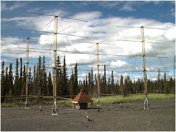
FIGURE 3.1 Photo of a riometer that employs a traditional or classic design. Shown here is the 30-MHz High Frequency Active Auroral Research Program (HAARP) riometer, which is part of a major ionospheric research facility located near Gakona, Alaska. This riometer uses a 2 × 2 array of five-element yagi antennas and a low-noise receiver to achieve a very sensitive receiver capability. SOURCE: HAARP, Office of Naval Research and the Air Force Research Laboratory. Image available at <www.haarp.alaska.edu/haarp/rioImages/rio.jpg>.
operation. Miniaturized, automated, low-cost receivers can be placed in widely distributed locations (for example, at schools and at remote sites). The combination of data from many receivers will provide a new dimension in observing capabilities.
Some spacecraft carry stable transmitter beacons whose amplitude and phase yield superb line-integrated estimates of plasma density and detection of plasma turbulence. These receivers are somewhat more costly, perhaps $20,000, and have modest network and power requirements. The premier example of such systems is the GPS TEC network, now very well established in North America, Japan, and Western Europe. Recently available digital receivers offer new flexibility, performance, and convenience of operation. The extension of the GPS network to cover remote regions, including oceans, would provide global, continuous observing of the useful TEC data.
High-Power Radar
Incoherent scatter radars (ISRs) are flagship instruments for ground-based ionospheric remote sensing. These radar systems have very large antennas and megawatt-class transmitters. The United States operates a chain of four such radars in the U.S. sector—in Greenland, Massachusetts, Puerto Rico, and Peru. Additional ISRs exist in Norway, the Norwegian Svalbard archipelago, Russia, and Ukraine.
ISRs directly detect Thomson scatter of VHF and UHF radio waves at ionospheric heights from 90 km to about 1000 km. The measurements permit reliable estimation of plasma density, temperature, drifts, and major ion composition, and with additional physics, it is possible to estimate electric fields and conductivities. Interconnection of the ISRs in real time through high-speed data distribution networks will enable coordinated high-resolution observations of interrelated regions of Earth’s atmospheric system. Modern ISRs have significant data communications and storage needs on site; it is highly desirable to have at least T1 (1.54 Mbps) connectivity to the Internet.
Most ISRs have steerable antennas that permit scanning a three-dimensional volume whose horizontal extent is (roughly) 2000 km. The capital cost of an ISR is approximately $25 million, and the annual operating cost is on the order of $1.5 million. Incoherent scatter radars can be operated in remote environments, but they have significant electricity needs to supply the powerful transmitters. Currently, most ISRs require significant staff for maintenance and operations. Workshop participants thought it unlikely that in the near future ISRs would be routinely operated without a human presence.
The Advanced Modular Incoherent Scatter Radar (AMISR) is a good example of a current high-power radar array (see Figure 3.2). AMISR is a phased-array, transportable ISR that is currently being put into operation. It represents a modern, flexible implementation of the ISR technique. AMISR augments and enhances the research capabilities of the current distribution of large ionospheric research radars by combining a powerful, state-of-the-art incoherent scatter radar with supporting optical and radio instrumentation in a transportable format. This flexibility enables the AMISR to study a wide range of ionospheric phenomena at polar, auroral, equatorial, and mid-latitudes and to act in close conjunction with other ground-based, suborbital, and satellite investigations of the geospace environment. The initial AMISR installation at Poker Flat, Alaska, will come on line in 2006.
Medium-Power Radar (Including Coherent Scatter and Meteor Radar)
Medium-power radars operate in the frequency range from a few megahertz to several hundred megahertz using transmitters that typically deliver from 1 to 50 kW of pulsed RF power. The lower power levels and smaller antenna sizes yield sensitivity that is 40 to 60 dB lower than an ISR’s sensitivity. Thus, medium-power radars do not have the sensitivity to detect incoherent scatter signals from the ionosphere. Nevertheless, meteor trails, field-aligned irregularities, and plasma frequency reflection provide large scattering cross sections that these smaller radars can detect.
There is a large class of medium-power radars known as “coherent” radars. Generally these radars detect some “coherent” feature whose scattering cross section is much larger than Thomson scatter. At the low-frequency end, medium-power radars interact with the D region and provide estimates of plasma drifts. At higher frequencies, 30 to 150 MHz, coherent radars detect magnetic field-aligned irregularities that are usually created by instabilities associated with electric currents or density gradients in the E (90 to 150 km) and F (150 to 1000 km) regions. Also, meteor ionization trails provide a small, high-density plasma column that can scatter detectable radiation. Plasma irregularities are intriguing in their own right; in the context of DASI these irregularities provide a means of detecting regions of unstable plasma and of tracing mean plasma flow. Careful study of meteor trails also provides information about winds and temperatures in the E region.
Essentially all of the coherent radars can be automated, and most require little, if any, intervention. The cost of medium-power radars is highly variable and dependent on the sophistication of the instrumentation. A fixed-frequency radar operating with a simple fixed beam antenna probably could be developed for under $50,000. However, most of the existing research instruments have been developed for $100,000 to $200,000, and the SuperDARN HF radars that utilize large HF antenna arrays have cost from $350,000 to $500,000 depending on site development costs and the extremity of the local wind and weather conditions (Figure 3.3).
The SuperDARN coherent HF radar network is an example of current medium-power radars. It employs nearly identical, largely automated HF radars to observe scattering of plasma irregularities in the E and F regions of the ionosphere. Currently, the network covers most of the northern and southern polar caps, with many of the stations reporting in real time.
The SuperDARN radar system primarily detects F-region irregularities, which are approximately “frozen in” to the mean convection. Although the irregularities are not always present, they are sufficiently ubiquitous to permit production of convection and electric field maps covering the high latitudes. With additional analysis, it is occasionally possible to characterize E-region scatter and gravity wave disturbances. The data rates are relatively low (for integrated data products), although even these
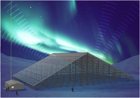
FIGURE 3.2 Artist’s concept of the portable Advanced Modular Incoherent Scatter Radar deployed at a high-latitude site to study the response of the upper atmosphere to auroral activity. SOURCE: Courtesy of J. Kelly and C.J. Heinselman, SRI International.
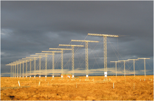
FIGURE 3.3 SuperDARN radar at Stokkseyri, Iceland. SOURCE: Courtesy of Jean-Paul Villain, French National Centre for Scientific Research.
low data requirements can stress communications capacity in Antarctica and Greenland. The SuperDARN network has a disciplined system of collecting and archiving data, an organizational model that may be very useful for DASI to draw on.
Low-Power Passive Radar
In recent years, several technology developments have enabled the creation of “passive” radars for atmospheric research. Passive radar systems are comparable in sensitivity and function to medium-power coherent scatter radars, but they have no dedicated transmitter and instead rely on existing transmitters of opportunity, in particular, commercial FM broadcasts. Systems using a variety of other transmitter types (such as digital TV transmitters) have been demonstrated for aerospace applications. Two passive radar networks for geophysical studies have been established to date and these systems have demonstrated, with high resolution in range (km), time (seconds), and azimuth (<0.1 deg), the detection of ionospheric turbulence, meteor trails, and aircraft. It is likely that such radars will also be able to detect polar mesospheric summer echoes if deployed in the correct location. Passive radars, which are typically operated in networks using several receiver locations separated by 100 to 400 km, provide ionospheric coverage of up to 4000 km2 per receiver pair. The network itself may provide significantly greater coverage by using the large number of available transmitters combined with multiple receiver locations.
The operation of passive radar systems differs from the operation of traditional radar systems. As receive-only systems, passive radars require electrical power similar to that of typical computer systems (under 1 kW). They also are characterized by modest antenna deployments (a few small yagi-type antennas) and moderate to high network communication bandwidths (100 kbps, and preferably far greater). The basic modes of operation are well within the capabilities of modern desktop computing systems. However, passive radar systems are most effective when large signal bandwidths are able to be transported over a data network to be analyzed using powerful correlation and signal-processing systems. Passive radar networks can be deployed incrementally to increase spatial coverage; in addition, the capability of these systems improves as more network bandwidth and computational power become available. Passive radar systems are able to operate continuously with very little manual intervention; the typical cost of a passive radar system is currently between $10,000 and $50,000 per site, depending on the level of system capability (see Figure 3.4).
For DASI deployment, spaced arrays designed to provide overlapping coverage can be established to monitor the occurrence of strong irregularities due to enhancements of the electric field over wide areas, and thereby provide an inexpensive global electric field monitor.
Ionosondes
Ionosondes are medium-power, frequency-agile radars that operate at high frequency. They provide a means to estimate the bottom-side density profile of the ionosphere by measuring the time of flight of radio waves to the altitude at which the local plasma frequency is equal to the radar frequency. Modern enhancements that include more complex antenna systems permit the study of large-scale waves and mean drifts. Ionosondes require several kilowatts of electricity, and their transmitters must be licensed. Ionosondes use relatively low frequencies, which means that the antennas require considerable space (on the order of 1 hectare), as well as several towers on the order of 20 m. Because they can perform all analysis automatically on site, they require only medium network speeds to distribute their data. In nearly all cases, ionosondes are highly automated. Depending on its capabilities, the cost of an ionosonde may vary from $40,000 to $500,000. Existing networks of digital ionosondes provide real-time information in support of developmental ionospheric data assimilation models.
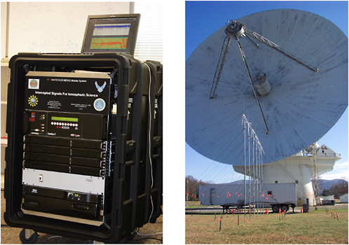
FIGURE 3.4 Left, an ISIS receiver deployed in the field at the National Radio Astronomy Observatory (NRAO) at Green Bank, W.Va. Courtesy of Massachusetts Institute of Technology. Right, foreground, is the Discone antenna array used by the ISIS node at Green Bank. In the background is the Green Bank 140-ft antenna.Courtesy of Glen Langston, NRAO. NRAO is a facility of the National Science Foundation operated under cooperative agreement by Associated Universities, Inc.
The Canadian Advanced Digital Ionosonde (CADI) array is being deployed around the ionospheric projection of the boundary between open and closed magnetic field lines (that is, the polar cap boundary). Each CADI instrument provides two basic types of ionospheric measurements: (1) ionograms that give information about ionospheric electron densities and vertical ionospheric structuring and (2) fixed frequency measurements that measure the Doppler shifts of the reflections and from which ionospheric flows can be calculated. CADI convection measurements have been validated against both SuperDARN convection measurements and velocities inferred from optical measurements of drifting auroral polar cap patches. The temporally continuous CADI data set complements the SuperDARN data set.
Distributed Arrays of Low-Frequency Antennas
The pace of advancements in computational power and network capacity will soon usher in a new era for radio astronomy in the form of next-generation, low-frequency, digital aperture synthesis radio interferometers. In a digital array, the signals from each antenna are digitized and sent to a central
processing facility for simultaneous viewing in multiple directions. Tracking of sources from many locations coupled with sophisticated real-time models of the ionosphere permits the extension of measurements down to previously unexplored low frequencies. Here the instrument itself is a distributed array that might consist of 10,000 dipole antennas distributed in a graduated pattern over 400 km.
At low frequencies, radiation from the sky exhibits temporally and spatially variable propagation delays as it passes through the ionosphere. By using tomographic restoration techniques, it will be possible to construct a precise three-dimensional view of ionospheric electron content on spatial scales and time scales far beyond anything currently available. Study of the plasma structure and variation on many size scales from tens of meters to hundreds of kilometers can advance understanding of the ionospheric response to solar-terrestrial disturbances and space weather events and will provide important input to ionospheric modeling.
MAGNETOMETERS
Arrays of magnetometers have contributed to understanding the ionosphere, magnetosphere, and solar wind ever since the creation of the first global network in the late 1830s. The successors to this first array have allowed researchers to understand geomagnetic storms, substorms, and the coupling of the solar wind with the magnetosphere and of the magnetosphere with the ionosphere. Indices such as Kp, Dst, and AE provide a measure of geomagnetic activity, and the study of ULF waves and their propagation enables probing the three-dimensional magnetosphere from the ground. Modern arrays of appropriately spaced digital magnetometers can monitor the plasma density distribution in the magnetosphere as well as help scientists understand the physics of MHD-wave resonance and propagation.
Magnetometer arrays are perhaps the simplest and most easily achieved autonomous instrument platform. Over a hundred ground magnetometer stations currently exist that can be used for space physics research, with a vast majority of these stations located at auroral and polar latitudes. But large swaths of Earth lack coverage, including most of Africa, Russia, South America, and the oceans.
Several autonomous magnetometer arrays are currently in operation, and next-generation autonomous platforms could support magnetometers and other instruments using only solar power and appropriate energy storage units (Figure 3.5). Autonomous data acquisition and communication via Iridium satellite links are also feasible. This type of installation would be intended for cold polar regions where power must be stored for the dark winter. Scientific magnetometers cost around $10,000 to $15,000. The need for autonomous low-power instruments for deployment in remote areas could add additional costs from $30,000 to $100,000, depending on the environmental requirements.
OPTICAL INSTRUMENTS
Passive Optical Instruments
The upper atmosphere contains atomic and molecular species that, under certain circumstances, can be energized to produce distinctive optical emissions. The most spectacular of these are the auroras, which can be seen with the unaided eye. Because atmospheric processes can take place on global scales, observations from a single site present a very limited view. Much information of great use can be obtained if instrument clusters can be operated as longitudinal and latitudinal chains. Optical observations are carried out most effectively when various types of instruments are operated in close proximity, viewing the same set of phenomena. Passive optical aeronomy has focused on studies of the
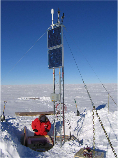
FIGURE 3.5 Installation of a prototype low-power magnetometer at the South Pole. The system is being designed to operate unattended for up to 3 years on the Antarctic plateau. SOURCE: Courtesy of Robert Clauer, University of Michigan.
mesosphere, thermosphere, and geocorona using three types of instruments—the all-sky imager, the Fabry-Perot interferometer, and the spectrograph.
A typical, modern, all-sky imager is a high-performance, solid-state imaging system that can be optimized to gather data indicative of particular kinetic processes occurring at relatively specific ranges of altitude. Imaging systems provide important information about neutral drifts as well as low- and high-latitude coupling through modification of airglow emission by plasma depletions along the magnetic field. The advent of modern digital photon sensors (such as charge-coupled devices) has made automatic operation with prompt reporting possible. Imaging sensors require clear, dark skies, which are achieved in regions with substantial clear weather, and little light pollution from human activities (the latter feature can impede network access).
The THEMIS ground array provides a current example of the synergy of space- and ground-based coordinated studies to address significant auroral-latitude processes (substorms). Program objectives are to utilize arrays of auroral optical imagers and magnetometers to provide real-time coverage of the auroral region across North America in order to locate and time the substorm onsets while simultaneously measuring plasma processes in the tail using a radial chain of satellites. At onset the aurora intensifies and expands, and the magnetic field caused by the ionospheric current intensifies.
The Fabry-Perot interferometer can now be employed in all-sky configurations. Dynamic and thermodynamic properties of the atmosphere can be determined from the Doppler shift and Doppler broadening of the emissions originating from various atmospheric species as a result of chemical reactions. New Fabry-Perot designs are suitable for deployment in low-power autonomous units.
Medium-resolution spectrometers are used to measure spectral bands from emitting species in the upper atmosphere. With a resolution of about 0.1 nm and a suitable low-light-level photodetector, it is possible to determine the rotational temperature of an atmospheric layer that is in thermal equilibrium with a molecular population that is the source of the emission. This is particularly useful in the stratosphere, mesosphere, and lower thermosphere. In most cases, such instruments are usable only for nocturnal and late-twilight conditions. Examples of such instruments include the Ebert-Fastie grating spectrometer, the echelle spectrograph, and the Fourier transform infrared spectrometer. Such instruments are available in automated form capable of unattended operation for extended periods and are able to report data over a network link. Figure 3.6 shows the complement of passive optical instruments deployed at a research site near Stockholm, Sweden.
Active Optical Instruments
It is also possible to probe the upper atmosphere with optical radars, called lidars. These instruments fall in two general classes: Rayleigh lidars, which collect light from the bulk medium, and resonance lidars, which probe individual quantum-mechanical transitions.
The Rayleigh lidars permit estimates of temperature profiles by studying the brightness of the scatter return as a function of altitude, and they are effective at altitudes up to about 75 km. With careful control of the powerful laser’s wavelength, some Rayleigh lidars can measure the Doppler shift of the scatter and therefore provide wind estimates for the middle atmosphere. Rayleigh lidars can also provide detection of mesospheric clouds (that is, noctilucent clouds) in which large particles significantly enhance the scatter of the laser light.
Resonance lidars are carefully tuned to probe quantum-mechanical resonances in the medium being sampled. Some resonances are especially bright, particularly for metal ions and atoms. By careful analysis of the spectral emission, it is possible to measure drifts and temperatures in the mesopause region with remarkable precision.
Active optical instruments are somewhat more tolerant of ambient light than are the passive systems. However, using currently available technology, precision optical systems and very-high-power laser emitters do not lend themselves to unattended operation. Although data network requirements usually are not large, the site costs for such systems can approach $1 million.
SOLAR MONITORING INSTRUMENTS
Ground- and space-based observations of the Sun and the heliosphere are complementary. Above Earth’s atmosphere, observations can be made at ultraviolet, X-ray, and gamma-ray wavelengths, and direct measurements can be made of the flux of energetic particles that make up the solar wind and solar flares. However, space-based instruments must be defined years to decades in advance, and repair and modification normally are not possible. In contrast, ground-based instruments can use state-of-the-art technology and can be configured and optimized for problems of current interest.
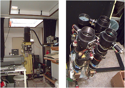
FIGURE 3.6 Instruments deployed in the field at Sandkullen, Sweden. Left: Ebert-Fastie spectrometer with an extremely high throughput that usually operates in the ultraviolet (instrument on loan from Johns Hopkins University). Right: A set of filter photometers that measure the atomic oxygen green line, molecular oxygen A-band, and hydroxyl radical Meinel band in the visible and near IR (as well as the scattered mercury green line at 540.6 nm and relevant continua). SOURCE: Stockholm University Department of Meteorology optical site at Sandkullen, Sweden. See <www.misu.su.se/~jacek/Ground/optsite.html>.
Ground-based optical, infrared, and radio observatories enable the study of the photosphere, chromosphere, and corona of the Sun with a spatial resolution and time span that cannot be duplicated from space platforms. In addition, high-temporal- and/or high-spatial-resolution observations in some cases require prohibitively large telemetry rates for satellite transmission, an issue that is largely avoided by ground-based observations. Ground-based instruments can also be deployed for a fraction of the cost of their space-based counterparts and can be maintained and upgraded for decades to provide the long time-series of observations required for understanding and ultimately predicting the solar cycle, solar variability, and the impacts these changes have on Earth.
Workshop participants noted two particular advantages that would be derived from deploying arrays of ground-based instruments across Earth:
-
Spatial distribution—In certain types of observations, the terrestrial location of the detection encodes information. For such observations, a widely distributed array of detectors is necessary to provide a broad field of view or to provide a wide range of energy sensitivity. Using Earth’s magnetic field as a spectrometer, the energy and direction of incoming solar or galactic energetic particles determine the location on Earth where the particles’ secondary products can by detected by a ground-based neutron monitor. Measuring the energy-resolved anisotropy of these particles requires an array of detectors covering a range of latitude and longitude.
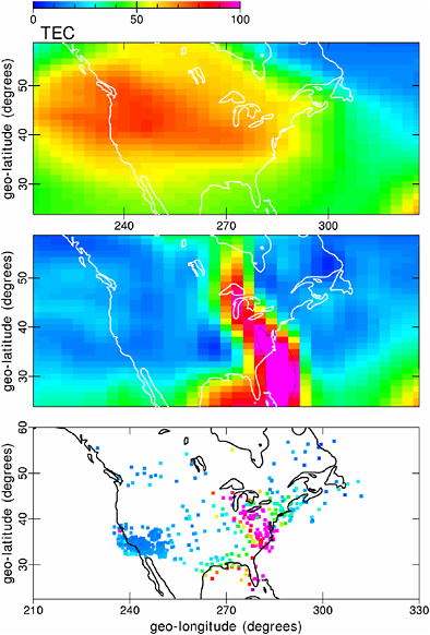
FIGURE 3.7 Data assimilation: a snapshot reconstruction of ionospheric total electron content for the geomagnetic storm in November 2003 shows (top) the output from a physics-based ionosphere forecast model with no data assimilation, (bottom) the measured TEC assimilated into the Utah State University GAIM data-assimilation model, and (middle) the final reconstruction combining the climatalogical background with the event-specific observations. SOURCE: Courtesy of J. Sojka, Utah State University.
-
Continuous temporal coverage—Distributed ground-based arrays are particularly suited for studies of the Sun that require long, continuous temporal coverage. Because such coverage is not possible from any single terrestrial vantage point, these types of observations require a globe-girdling chain of detectors. This capability is of particular importance for studies, such as in helioseismology, where periodic data gaps are detrimental to frequency resolution. It is also critical for capturing the key stages of solar dynamics. For example, a single ground-based facility cannot be used to study the complete emergence of an active region, because this process takes 24 hours or more. On the other hand, CMEs and flares are each brief enough that individual events can be observed from a single vantage point. However, since a single ground station would observe for only part of the day, all or part of these dynamic events could be missed. Furthermore, observing conditions preceding, during, and following CMEs and flares are vital to understanding these events, each of which is unique. Ground-based observations will be the only resource for white light coronagraph observations of CMEs once existing space-based coronagraph missions end (~2008). Although such solar activity monitors would necessarily be relatively large systems, only three to six would be needed for full temporal coverage. Distributed arrays dramatically increase the continuity of temporal coverage by maximizing observing time and minimizing the loss of observations due to weather conditions.
DATA-ASSIMILATING COMPUTER MODELS
Although not instruments per se, computational models linked to observational data are a key requirement for major advances in upper atmosphere research and in space weather “nowcasting” and forecasting. Computational models can employ increasingly accurate mathematical representations of the physics of the upper atmosphere, both in the detail of theory and in the temporal and physical resolution of the medium. By including data assimilation in the modeling algorithms, it is possible to evaluate the models with real-time input from geographically distributed sensors. The underlying mathematical physics models can provide excellent results if they are constrained by well-distributed data (see Figure 3.7).
These modeling efforts provide key technology guidance for the development of new instrumentation for DASI. The most useful data input to the models is not necessarily that of very-high-resolution measurements made at a few locations. Instead, the computational models readily accept lower-resolution data that has wide spatial coverage and continuity in time.


