


Below is the uncorrected machine-read text of this chapter, intended to provide our own search engines and external engines with highly rich, chapter-representative searchable text of each book. Because it is UNCORRECTED material, please consider the following text as a useful but insufficient proxy for the authoritative book pages.
Cooper, A. K., P. J. Barrett, H. Stagg, B. Storey, E. Stump, W. Wise, and the 10th ISAES editorial team, eds. (2008). Antarctica: A Keystone in a Changing World. Proceedings of the 10th International Symposium on Antarctic Earth Sciences. Washington, DC: The National Academies Press. Tectonics of the West Antarctic Rift System: New Light on the History and Dynamics of Distributed Intracontinental Extension C. S. Siddoway1 ABSTRACT and the context for active volcanism (Behrendt et al., 1994, 1996) arising at a time of instability of the West Antarctic The West Antarctic rift system (WARS) is the product of ice sheet, when information is sought about the inï¬uence of multiple stages of intracontinental deformation from Juras- underlying crustal structures on glaciological and glacial- sic to Present. The Cretaceous rifting phase accomplished marine systems (e.g., Holt et al., 2006; Lowe and Anderson, >100 percent extension across the Ross Sea and central West 2002; Vaughan et al., 2006). The question of heat ï¬ux arising Antarctica, and is widely perceived as a product of pure shear from warm mantle beneath thinned crust is of obvious conse- extension orthogonal to the Transantarctic Mountains that led quence for ice-sheet dynamics (Maule et al., 2005). The area to breakup and opening of the Southern Ocean between West of thin crust corresponding to the WARS (Figure 1) includes Antarctica and New Zealand. New structural, petrological, the Ross Sea and Ross Ice Shelf, the West Antarctic ice sheet and geochronological data from Marie Byrd Land reveal (WAIS), and Marie Byrd Land (Behrendt et al., 1991; Storey aspects of the kinematics, thermal history, and chronology of et al., 1999; Fitzgerald, 2002; Siddoway et al., 2005). the Cretaceous intracontinental extension phase that cannot In the geological record the WARS has distinctive but be readily explained by a single progressive event. Elevated differing expressions in both Cenozoic and Mesozoic time. By temperatures in âLachlan-typeâ crust caused extensive far the better-known rift phase is the mid-Cenozoic to Pres- crustal melting and mid-crustal ï¬ow within a dextral trans- ent interval. Widespread basaltic volcanism (Behrendt et al., current strain environment, leading to rapid extension and 1994, 1996; Finn et al., 2005; Rocchi et al., 2005), slow mantle locally to exhumation and rapid cooling of a migmatite dome seismic velocities (Danesi and Morelli, 2001; Ritzwoller et and detachment footwall structures. Peak metamorphism and al., 2001; Sieminski et al., 2003), and anomalous elevation onset of crustal ï¬ow that brought about WARS extension of thinned continental crust (LeMasurier and Landis, 1996; between 105 Ma and 90 Ma is kinematically, temporally, LeMasurier, 2008) are the hallmarks of the Cenozoic rift. The and spatially linked to the active convergent margin system Victoria Land Basin and Terror rift, on the western limit of the of East Gondwana. West Antarctica-New Zealand breakup WARS, record modest extension on the order of 150 km in is distinguished as a separate event at 83-70 Ma, from the Eocene-Oligocene time (Stock and Cande, 2002; Davey and standpoint of kinematics and thermal evolution. DeSantis, 2006). The dramatic relief of the Transantarctic Mountains (TAM) developed in the Eocene (ten Brink et al., INTRODUCTION 1997; Fitzgerald, 2002), and voluminous basin sedimentation commenced (Hamilton et al., 1998; Cape Roberts Science Heightened interest in West Antarctica (WANT) and the West Team, 2000; Luyendyk et al., 2001; Karner et al., 2005), Antarctic rift system (WARS) comes from new determina- considerably later than major extension in the WARS. Not tions of the mantle thermal proï¬le (Lawrence et al., 2006) surprising in light of the dominantly Eocene activation of the TAM boundary (ten Brink et al., 1997; Fitzgerald, 2002), on- 1 Department of Geology Colorado College, Colorado Springs, CO 80903, land structures attributable to preceding Cretaceous events are USA (csiddoway@coloradocollege.edu). few in the TAM (Wilson, 1992). 91
92 ANTARCTICA: A KEYSTONE IN A CHANGING WORLD ing regional unconformity RU6 evidently was delayed until the Eocene to Miocene (Hamilton et al., 1998; Wilson et al., 1998; Cape Roberts Science Team, 2000; Luyendyk et al., 2001; Karner et al., 2005). This is despite the rapidity of the large magnitude extension, on the order of 600 km in the south, up to >1000 km in the north achieved in as little as 20 m.y. (DiVenere et al., 1996; Luyendyk et al., 1996). A second paradox is that breakup between WANT and New Zealand (NZ) did not exploit rift structures but rather cut at a high angle across basement highs and basins of the Ross Sea (Tessensohn and Wörner, 1991; Lawver and Gahagan, 1994; örner, rner, Sutherland, 1999). Wrench deformation and the presence of strike slip transfer systems was postulated (Grindley and Davey, 1982) but not substantiated from exposures on land. New perspective on intracontinental extension in the WARS comes from geological and geophysical research that investigates the exposed bedrock of WANT, NZ, and the Tasman Sea region (Figure 1). WANT, NZ, and subma- rine plateaus formed a contiguous segment of the conver- gent margin of East Gondwana in Early Cretaceous time, with arc magmatism recorded in Marie Byrd Land-NZ. Transtensionâextension occurred in a back arc to inboard setting, forming the intracontinental West Antarctic rift sys- FIGURE 1 The Cretaceous West Antarctic rift system at ca. tem and Great South Basin-Campbell Plateau extensional 90 Ma, illustrating the positions of Marie Byrd Land and New province (Figure 1). Zealand/Campbell Plateau along the East Gondwana margin. The Since 1990, data acquired from geological investigations rifted margin corresponds to the â1500 m contours (dashed-line on land and from airborne and marine geophysical surveys in pattern). The tight ï¬t of the reconstruction, the linear to curvilinear the region of Marie Byrd Land have dramatically increased continental margin, and the pronounced depth increase suggest the understanding of the eastern WARS, with consequences fault control and steep fault geometry. The diagram is based on for our conception of the Cretaceous to Present multistage the reconstructions of Lawver and Gahagan (1994) and Sutherland (1999). The present-day position of the Transantarctic Mountains, evolution of the West Antarctic rift system as a whole. The as labeled, corresponds to the western tectonic boundary of the West aim of this paper is to summarize the tectonic evolution of Antarctic Rift System. FM = Fosdick Mountains; EP = Edward VII western Marie Byrd Land (MBL) (Figure 2) and of neighbor- Peninsula; 270 = DSDP site 270. ing segments of the proto-Paciï¬c margin of East Gondwana (Figure 3). Little affected by Cenozoic events (cf. Fitzgerald, 2002; Stock and Cande, 2002), the eastern Ross Sea region The lesser-known phase of extension and lithospheric preserves a clear record of the kinematics, magmatism, and thinning that brought about formation of the vast rift system thermal history of the Early Cretaceous large-scale opening (~1.2 106 km2) did not occur in Cenozoic but in Mesozoic of the WARS. time (Tessensohn and Wörner, 1991; Lawver and Gahagan, örner, rner, Knowledge of the Cretaceous tectonic evolution of 1994; Luyendyk, 1995). Although the origins of the WARS the WARS-NZ-Tasman Sea region provides an important may be linked to Weddell Sea opening and Ferrar magmatism foundation for contemporary research in WANT, including in the Jurassic (Grunow et al., 1991; Wilson, 1993; Jokat et studies of the Cretaceous to present landscape evolution al., 2003; Elliot and Fleming, 2004), dramatic intracontinen- (LeMasurier and Landis, 1996; LeMasurier, 2008) involving tal extension occurred in Cretaceous time. Much of the basis a postulated orogenic plateau (Bialas et al., 2007; Huerta, of knowledge about the Ross Sea sector of the rift comes 2007), the origins of the Southern Oceanâs diffuse alkaline from ocean bottom seismograph, multichannel seismic magmatism (Finn et al., 2005; Rocchi et al., 2005), the causes reï¬ection, and gravity surveys that revealed a N-S structure for Cenozoic structural reactivation (e.g., Salvini et al., 1997; of elongate basins marked by a positive gravity anomaly Rossetti et al., 2003a,b) and seismicity (Winberry and Anan- and high seismic velocities in the lower crust and 1-4 km dakrishnan, 2004), and the affects of inherited structures of inferred Mesozoic sedimentary ï¬ll (Cooper and Davey, upon ice-bedrock interactions of the dynamic WAIS (Lowe 1985; Cooper et al., 1997; Trey et al., 1997). Paradoxically, and Anderson, 2002; Holt et al., 2006; Vaughan et al., 2006; major sedimentary inï¬lling of basins with material postdat- Sorlien et al., 2007).
SIDDOWAY 93 Extent of the West Antarctic Rift System (WARS) and These are intruded by Cretaceous alkalic plutonic rocks Character of WARS Crust (Figure 4) that are genetically linked to the WARS (Weaver et al., 1992, 1994). Lower Paleozoic Swanson Formation The region corresponding to the Cretaceous WARS includes represents one of the packages of voluminous quartz-rich the Ross Sea and Ross Ice Shelf, the area of the WAIS, and turbidites deposited in regionally extensive clastic fans shed Marie Byrd Land (Behrendt, 1991, 1999; Behrendt et al., from the Ross-Delamerian Orogen (Fergusson and Coney, 1991; Cooper et al., 1991a,b; Storey et al., 1999; Trey et 1992) or distant Transgondwana orogen (Squire et al., 2006). al., 1999). Measured orthogonal to the TAM, the WARS The rock assemblages that were contiguous along the East widens from 600 km in the south (Storey et al., 1999) to Gondwana margin (Figure 3) include the Swanson Forma- 1200 km across the northern Ross Sea (Luyendyk et al., tion in MBL (Bradshaw et al., 1983), the western Lachlan 2003). Thickness of continental crust ranges from 17-19 km Belt in Australia (Glen, 2005), the Robertson Bay group in for the Central and Eastern Basins of the Ross Sea to 23-24 north Victoria Land (NVL) (Rossetti et al., 2006), and the km beneath basement highs (Cooper et al., 1991b, 1997; Greenland Group in NZ (Cooper and Tulloch, 1992; Adams Davey and Brancolini, 1995; Luyendyk et al., 2001). There et al., 1995, 2005; Gibson and Ireland, 1996; Adams, 2004; is a similar range beneath central West Antarctica (Behrendt Bradshaw, 2007). et al., 1994; Bell et al., 1998). The crust underlying western The Swanson Formation was deformed and metamor- MBL is ca. 23 km thick, based on airborne geophysics (Fig- phosed to low greenschist grade (Adams, 1986) prior to ure 2) (Ferraccioli et al., 2002; Luyendyk et al., 2003). This emplacement of latest Devonian to Carboniferous calc- provides evidence that the region of western MBL that is alkaline plutons of the Ford Granodiorite (Figure 3) (Adams, above sea level is part of the WARS province. 1987; Weaver et al., 1991). Ford Granodiorite represents The western margin of the WARS extensional province the ï¬rst in a succession of convergent margin arcs devel- coincides with the TAM, at the long-standing tectonic bound- oped upon the East Gondwana margin from Ordovician ary of the East Antarctica (EANT) craton that initiated as a through Early Cretaceous time (Pankhurst et al., 1998), and Neoproterozoic rift margin (Dalziel, 1997), underwent con- it has correlatives in New Zealand (Muir et al., 1996). Both vergence during the Ross Orogeny (Stump, 1995), and was Swanson Formation and Ford Granodiorite were affected by reactivated during the initial two-plate phase of Gondwana high-temperature (HT) metamorphism and their high-grade breakup in the Jurassic Era (Dalziel et al., 1987). Tholeiitic equivalents are exposed in the Fosdick Mountains migma- Ferrar magmatism (Elliot et al., 1999; Elliot and Fleming, tite gneiss dome (Siddoway et al., 2004b; Saito et al., 2007) 2004) and modest extension to transtension initiated in the (Figure 4). Temperatures in excess of 800°C, sufï¬cient to WARS at this time (Storey, 1991, 1992; Wilson, 1993). The cause voluminous melting, were attained two to three times Cretaceous WARS has been inferred to be an asymmetrical in the history of the dome (Siddoway et al., 2006; Korhonen extensional system with the TAM forming the structural et al., 2007a,b). The most recent migmatization phase coin- upper plate and the WARS, the lower plate (e.g., Fitzgerald et cided with alkalic plutonism in MBL marked by Byrd Coast al., 1986; Stern and ten Brink, 1989; Fitzgerald and Baldwin, granite and maï¬c dikes (Weaver et al., 1992, 1994; Adams 1997; compare Lister et al., 1991). et al. 1995; Siddoway et al., 2005). Beneath the Ross Sea, gravity and marine seismic data Pankhurst et al. (1998) introduced the term âRoss delineate a crustal structure of N-S grabens, marked by high- Provinceâ for the Swanson-Ford association in western density material in the axial regions, separated by basement MBL (Figure 2). Correlatives of the Ross Province exist highs. A large positive gravity anomaly in the basin axes is throughout the former Gondwana margin, including a interpreted as maï¬c igneous material emplaced into the lower number of culminations of HT metamorphic rocks derived crust (Cooper et al., 1997; Trey et al., 1997). Sedimentary from Paleozoic protoliths (Tulloch and Kimbrough, 1989; ï¬ll in the deep basins is cut by faults and overlapped by Morand, 1990; Ireland and Gibson, 1998; Vernon and John- a regional unconformity, RU6, that predates thick glacial son, 2000; Richards and Collins, 2002; Hollis et al., 2004) sediments. The thickness of Mesozoic to early Tertiary sedi- (Figure 4). It is probable that Ross-Delamerian orogenic ments is comparatively modest, reaching 4 km in the Eastern sediments and the intermediate plutonic rocks that intrude Basin, diminishing toward the coast of MBL (Luyendyk et them constitute the majority of the crust within the Ross al., 2001). Sea sector of the WARS (Bradshaw, 2007), its continua- In a region of thinned crust but exposed above sea tion into New Zealand (e.g., Cook et al., 1999), and into level, the Ford Ranges and Edward VII Peninsula (Figure the submerged extended continental crust bordering the 2) are key locations for examining the crust that constitutes Tasman Sea. Within the WARS crust, there is also sparse the WARS and observing the structures responsible for the evidence of âRoss-agedâ basement rocks with an afï¬nity to Cretaceous extension. The oldest rocks exposed are Swan- the TAM (Fitzgerald and Baldwin, 1997; Pankhurst et al., son Formation metagreywacke and Ford Granodiorite of 1998; Bradshaw, 2007). Paleozoic age (Bradshaw et al., 1983; Weaver et al., 1991).
94 ANTARCTICA: A KEYSTONE IN A CHANGING WORLD -155 -150 -145 -140 -135 -75 Nickerson Demas Ice Shelf Range Southern Ocean . d Gl Amundsen Lan Province s Ba Ford R a n g e Fosdick Mts lch Phillips Mtns. Executive Comm. Range en -76 Gl. s s ce Marie Prestrud Rock, Cape Sc Nunatak ott o R vin Byrd Bo m Colbeck Ha yd ond -77 Land m o G Pr Allegheny l. Gl. Alexandra Mtns Mtns Edward VII Peninsula Rockefeller Mtns st ed cru -78 Ice elevation Area of sub-glacial in meters volcanoes, inferred 2500 Trans Ross t end Sea Area of from aeromagnetics figure 2000 anta f ex rc t 1500 ic -79? Mo it o nt u ain s 1000 l im 500 ed err 0 Inf -80 FIGURE 2 Eastern Ross Sea and western Marie Byrd Land location map. Inferred limits of extended crust and a subglacial volcanic ï¬eld, determined from airborne geophysics (Luyendyk et al., 2003) are indicated. The Ross Province (Pankhurst et al., 1998) of the Ford Ranges comprises lower Paleozoic sedimentary rocks intruded by Devono-Carboniferous intermediate plutons. The rock exposures east of Land Glacier are dominated by intermediate to maï¬c arc-related plutonic rocks, with subsidiary, younger alkalic intrusions; an association termed the âAmundsen Provinceâ by Pankhurst et al. (1998). Base map by D. Wilson. THE ACTIVE MARGIN OF EAST GONDWANA AND of intermediate plutonism spanning the interval 124 to 96 Ma FORMATION OF THE MESOZOIC WEST ANTARCTIC (Pankhurst et al., 1998; Mukasa and Dalziel, 2000). RIFT SYSTEM The timing of HT metamorphism in NZ is determined by U-Pb ages on metamorphic zircon or titanite sampled from Convergent Margin Plutonism gneisses at sites distributed along the convergent margin. These include the Paparoa range at 119-109 Ma (Kimbrough Mesozoic convergent tectonism with intermittent subduc- and Tulloch, 1989; Ireland and Gibson, 1998; Spell et al., tion-related plutonism and terrane accretion is recorded 2000); and Fiordland at 126-110 Ma (Ireland and Gibson, in West Antarctica (Vaughan and Livermore, 2005) and 1998; Hollis et al., 2004; Scott and Cooper, 2006). Granulite contiguous parts of NZ (e.g., Bradshaw et al., 1997). The metamorphism documented in Fiordland at 108 ± 3 Ma (Gib- calc-alkaline, I-type Median Batholith was emplaced in NZ son and Ireland, 1995) gives an indication that elevated and between 145 Ma and 120 Ma, with some ages older, to 170 compressed crustal isotherms developed during convergent Ma (Muir et al., 1998; Mortimer et al., 1999a,b; Tulloch tectonism (Figure 5). and Kimbrough, 2003); and tectonic reconstructions show In the Fosdick Mountains gneiss dome in MBL, new continuity of the magmatic arc, together with associated U-Pb SHRIMP ages of 115 ± 1 Ma have been acquired for tectonic terranes, into MBL-Thurston Island (Figure 3) (e.g., igneous zircon within K-feldspar leucogranite equated with Bradshaw et al., 1997). The arc province in MBL, termed the anatectic leucosome, that has been sampled at deepest struc- âAmundsen Provinceâ (Pankhurst et al., 1998), was the site tural levels (Siddoway et al., 2006). Nd isotope data indicate
SIDDOWAY 95 M ed ia n Ba th 15 ol 0E Lachlan ith Belt c. 80 Ma opening Bo RBT S we 60 rs Ter ra ne Sw 180° 120°E 300° 30 E W 60 000° FIGURE 3 Tectonic correlation between terranes of north Victoria Land, West Antarctica, and New Zealand/Campbell Plateau, compiled from Bradshaw (1989) and Bradshaw et al. (1997). Reconstruction of the Cretaceous East Gondwana margin is based on Gaina et al. (1998) and Kula et al. (2007), with oceanic plates conï¬guration based on Sutherland and Hollis (2001) and Larter et al. (2002). Representation of oceanic plateaus is based on Taylor (2006) and Hoernle et al. (2004). Lower Paleozoic orogenic sediments are shown in olive green and tan. Belt of Cretaceous magmatism is shown in violet. Paparoa metamorphic core complex in the Western Province (WP), Fosdick gneiss dome in Marie Byrd Land (MBL), and detachment systems are marked by ellipses. TAS = Tasmania; RBT = Robertson Bay terrane; EP = Eastern Province; Sw = Swanson Formation; LHR = Lord Howe Rise; CR = Chatham Rise; TI = Thurston Island terrane. a Ford Granodiorite source for the leucogranites (Saito et al., 1998), those of the Separation Point and Rahu suites in the 2007) at T, P conditions of 820-870°C and 6.5-7.5 kbar deter- Western Province and the deeper level Fiordland Orthog- mined from mineral equilibria modeling (Korhonen et al., neiss in Fiordland. The Rahu suite granites are interpreted to 2007a,b). There is evidence of metamorphic zircon growth as derive from crustal melting of preexisting rocks (Ireland and early as ca. 140 Ma. A summary of U-Pb SHRIMP analyses Gibson, 1998). Thus, the conditions for HT metamorphism of igneous and metamorphic zircon from Fosdick Mountains and granite genesis in the Fosdick Mountains were attained migmatites (Figure 6) reveals that there is a bimodal distribu- and overlapped in time with arc plutonism in the Median tion of ages. Whereas HT metamorphism and zircon growth Batholith and in the Amundsen Province. is recorded as early as 150 Ma, a majority of points analyzed By contrast, the alkaline plutonism attributed to back-arc thus far fall within the interval of 120-100 Ma. Anatectic extension occurred in eastern MBL (Figure 5) at 105-102 Ma leucosomes from sites in MBLâs Amundsen Province, the (Weaver et al., 1992, 1994; Mukasa and Dalziel, 2000), dis- Demas Range (Figure 2) yield ages of 128 Ma to 113 Ma tinctly later than onset of high temperature metamorphism. In for igneous zircon (Mukasa and Dalziel, 2000). The MBL western MBL the Ford Ranges experienced alkalic plutonism data fall within the 126-107 Ma age range of the youngest at 105-103 Ma and ca. 99 Ma (Richard et al., 1994) and in arc-related intrusions identiï¬d in NZ by Muir et al. (1997, Edward VII Peninsula at 103-98 Ma (Mukasa and Dalziel,
96 ANTARCTICA: A KEYSTONE IN A CHANGING WORLD e 147 E 145 E 143 E ur ct ru st c oi oz PHILL IPS MOUNTAINS B en N AL C C H ed EN rr GL fe AC in IE ? B A R L C H FAULT E N G L A C I E R - Mt. Mt Mitchell Pk Mt. Lockhart Bitgood Bird ? 88 5 Ma Avers Bluff ? 13.7 1 m FOS ? DICK MOUNTAINS lt 76 30âS M u S F fa M D Z Mt. s Mt. in Richardson Getz rk e P M t. I E R M Chester Mtns A C 95 6 Ma ? E Y G L L L 13.5 1.6 m V A S E S U L Z B E R G E R V A S C R E A n = 33 MT. PASSEL M U D U D Swanson Rg. M 1000 m G L A C I E R B n = 13 A R T H U R H I C E M A The M Billboard M Mt. Crow 91 4 Ma O 77 S SA N RN D B U D O FF S H E LF O MT N S.. Y G D LA ALLEGHENY G L A MTNS. C C I Mt. Darling IE E R CLARK C R Mt. Woodward. MTNS. n = 42 Mt. Douglass in 97 5 Ma fe 13.7 1 m rr ed fa ul t McKAY Contour interval, 200m MTNS. L= 5 F n = 16 E n=6 D n = 21 0 10 20 30 40 50 km Key to Units Q Basalt, Pleistocene K Byrd Coast Granite K Fosdick migmatite D-C Ford Granodiorite ePz Swanson Formation FIGURE 4 Structural-geological map of the Ford Ranges, western Marie Byrd Land. Inferred faults that are concealed by ice are mapped on the basis of contrasts in metamorphic grade between ranges, geophysical lineaments or boundaries, and zones of penetrative brittle deforma- tion in rock exposures. AFT cooling ages and track lengths (Richard et al., 1994; Lisker and Olesch, 1998) are indicated for selected sites. Brittle mesoscopic fault data are shown in stereographic plots (insets). Sites and kinematic sense are as follows: (A) southern Ford Ranges, normal oblique; (B) Mt. Darling, sinistral (Cenozoic); (C) southern Ford Ranges, sinistral oblique; (D) Sarnoff Range, normal oblique; (E) Mt. Crow, sinistral; (F) Mt. Woodward, sinistral oblique. The label âMâ indicates sites of glacial deposits examined for clast provenance. Stereonet v. 6.3.3 and FaultKin 4.3.5, by R. Allmendinger 1989-2004, were used for plotting stereographic diagrams. Shaded relief ice topography and base map prepared from Antarctic Digital Database by G. Balco.
SIDDOWAY 97 FIGURE 5 Conceptualization for development of the West Antarctic rift system inboard of the Mesozoic convergent margin during oblique plate convergence and subduction of young oceanic lithosphere, including oceanic plateaus. Top: Crustal thickening and advective heating during development of Amundsen province magmatic arc; active margin undergoing transpression due to oblique convergence. Middle: Heat- ing of the lower crust causes partial melting and lateral ï¬ow in the middle and lower crust; thermal gradient is increased. Thickening of the crust continues but the lower lithosphere thins. Upper crust undergoes brittle faulting. Bottom: Change to transtension, with oblique opening across preexisting high-angle faults. Lateral ï¬ow of hot, weak, partially molten lower crust is accompanied by brittle deformation in shallow upper crust. Strain perturbation along faults allows localized gravity-driven vertical ï¬ow of lower-density migmatite-diatexite and formation of gneiss dome(s). Isotherms are elevated, tectonic exhumation and cooling are enhanced, next to transcurrent faults.
98 ANTARCTICA: A KEYSTONE IN A CHANGING WORLD 2000; Siddoway et al., 2004a). The dominant plutonic rock a view of crustal rheology, kinematics, and dynamics of is Byrd Coast Granite (Figure 4). Maï¬c alkalic dikes and Cretaceous tectonism that pertain to the West Antarctic rift syeno-granites were emplaced over a wide region. A dolerite system as a whole. dike swarm at 107 ± 5 Ma was followed closely by 102-95 Ma syenite and alkalic granite in the Amundsen province The Fosdick Mountains Gneiss Dome (Storey et al., 1999). A wider a range of dike ages, 142 to 96 Ma, comes from the Ross Province (Siddoway et al., 2005). The Fosdick Mountains form an elongate migmatite gneiss In the Ross province an early phase of Byrd Coast alkalic dome (Wilbanks, 1972; Siddoway et al., 2004b) delimited granite from the Allegheny Mountains is ca. 142 Ma, and by a S-dipping, dextral-oblique detachment zone on the another at Mt. Corey is 131 Ma (Figure 2) (Adams, 1987). south (McFadden et al., 2007) and by an inferred steep Subduction ceased in New Zealand at 105 ± 5 Ma (Muir et dextral strike-slip zone on the north, the Balchen Glacier al., 1994, 1995, 1997, 1998). fault (Siddoway et al., 2004b, 2005). From lower to higher Alkalic magmatism in NZ coincided with extension, structural levels, gneisses that exhibit features indicative of development of a regional unconformity, and dramatic melt-present ductile ï¬ow give way to mylonitic rocks exhib- sedimentation, including thick deposits of sedimentary iting mixed ductile-brittle deformation textures, indicative of breccia (Laird and Bradshaw, 2004). Metamorphic core solid-state deformation (McFadden et al., 2007). Kinematic complexes developed in South Island (Figure 3) (Tulloch and axes calculated from nappe-scale folds and subsidiary folds, Kimbrough, 1989; Forster and Lister, 2003), together with mineral lineation, and anisotropy of magnetic susceptibility deep level shear zones that were active in Fiordland (Gibson (AMS) fabrics within the 15 80 km dome are subhorizon- et al., 1988; Scott and Cooper, 2006). tal, 065 to 072. The orientation is oblique to the long axis of The Lachlan belt on continental Australia and Robertson the dome and to the Balchen Glacier fault. Bay terrane in NVL occupied an inboard position in middle The migmatite gneisses forming the core of the Fosdick Cretaceous time and did not experience tectonism related Mountains dome reached temperatures (T) and pressures (P) to the active margin (Figure 3), although Australia-EANT of the upper amphibolite to granulite facies (Siddoway et al., breakup was in its initial stages (Li and Powell, 2001, and 2004b; Korhonen et al., 2007a). Granite formed by biotite references cited). Remnants of the active margin are the breakdown (Saito et al., 2007) forms sheets, stocks, and submarine plateaus that border the Tasman Sea and provide extensive interconnected networks on a scale of hundreds a sparse geological record of the change in plate dynamics of meters. Leucogranite occupies structural sitesâwithin (Tulloch et al., 1991; Mortimer et al., 1999a, 2006; Mortimer, foliation-parallel sheets, shear bands, and interboudin 2004). necksâsuggestive of deformation-enhanced migration and coalescence of melt products (Sawyer, 2001). Concordant layers of leucogranite may exceed 10 m in thickness. New GEOLOGICAL STRUCTURE OF THE FORD RANGES, U-Pb SHRIMP zircon studies (Siddoway et al., 2004b, 2006; MARIE BYRD LAND: DATA BEARING ON TECTONISM McFadden et al., 2007) and isotope geochemistry (Saito et IN THE WEST ANTARCTIC RIFT SYSTEM al., 2007) aid in the task of determining the extent and distri- In MBL the general absence of dynamic fabrics in plutonic bution of anatectic granites formed in Late Cretaceous time, units and the elusive nature of crustal-scale faults in a region coincident with development of the WARS. with extensive ice cover have long hindered the understand- At intervals along the Fosdick Mountains dome, leuco- ing of the strain evolution. New progress has been made in granite sills form vertical sequences that reach 1000 m in the region through tectonic investigations focused on the thickness (âleucogranite sheeted complexâ of McFadden et structure and metamorphic petrology of the Fosdick Moun- al., 2007). The thin layers (<1-3 m) of para- and orthogneiss tains gneiss dome (Siddoway et al., 2004b; Korhonen et al., that separate the sills contain microstructures indicative of 2007a; McFadden et al., 2007), the conï¬guration of maï¬c the former presence of melt and of deformation mechanisms dikes representing a regional tensile array (Siddoway et al., dominated by melt-assisted grain boundary diffusion creep. 2005), and kinematic analysis of mesoscopic brittle faults Kinematic data obtained from the horizons of shallowly (Luyendyk et al., 2003). Airborne geophysical data over dipping paragneiss and orthogneiss include fold axes of the Ford Ranges (Luyendyk et al., 2003), and Edward VII symmetrical, tight to isoclinal recumbent folds that trend Peninsula (Ferraccioli et al., 2002) delineate regional-scale 062-242 (n = 118), and sparse mineral lineation aligned faults. Geochemical investigations reveal the granite petro- 072-252 (n = 38) (Siddoway et al., 2004b). The consistent genesis (Pankhurst et al., 1998; Mukasa and Dalziel, 2000; linear data suggest ENE-WSW stretching under suprasolidus Saito et al., 2007) and U-Pb geochronology provide critical conditions when the leucogranite sheets were emplaced. The age control (Siddoway et al., 2004a,b, 2006; McFadden et layers of paragneiss and orthogneiss in this setting are âdia- al., 2007). A review of the recent ï¬ndings from MBL in the texiticâ (Brown, 1973; Milord et al., 2001), in that the color next section will begin with the lower crustal exposure pro- distinction between leucosome and melanosome is subdued, vided by the Fosdick Mountains, where migmatites provide with melanosome a light grey color, and boundaries between
SIDDOWAY 99 the light- and darker-colored portions, indistinct. Diatexite dextral normal oblique shear sense, with top-to-the-SW textures indicate a high degree of chemical interaction of transport along azimuth 240. Foliation dips steepen from leucogranite melt with host gneisses under suprasolidus west toward east, and give way to strong subhorizontal L- conditions (Sawyer, 1998, 2004). Conventional thermo- tectonite fabrics trending 070-075 within Ford-phase grano- barometry carried out on the diatexitic paragneisses yielded diorite at Mt. Richardson (Figure 4). U-Pb SHRIMP zircon P = 4 kbar to 6 kbar and T = 680°C to 780°C (Smith, 1992, data bracket the time of deformation upon the South Fosdick 1997; Siddoway et al., 2004b). New results of comparative detachment zone between 107 Ma and 96 Ma (McFadden et thermobarometry using THERMOCALC indicate consider- al., 2007). ably higher conditions of 820-870°C and 6.5-7.5 kbar for the Cretaceous peak (Korhonen et al., 2007a,b). The leucogranites exhibit compositional layering and igneous microstructures, such as euhedral grains and til- 30 Bins, 2 Ma ing of large feldspars; together with evidence of magmatic solid-state deformation (Blumenfeld and Bouchez, 1988; 25 Fosdick Mountains, U-Pb zircon Weinberg, 2006) such as mechanical kinking at grain-to- from leucogranite (igneous zircon and metamorphic rims), n = 127 grain contacts in coarse-grained phases. The textures sug- 20 gest that the interstices between solid phases represented a permeable melt network through which melt ï¬owed. The 15 migmatite structures of the Fosdick Mountains suggest that sills and leucosome networks are remnants of a melt transfer 10 system that allowed magma ï¬ux through a zone of anatexis (e.g., Olsen et al., 2005; Weinberg, 2006) within the middle 5 and lower crust (e.g., Brown and Pressley, 1999; Brown, 2007). Deformation aided melt-migration and melt enhanced 0 deformation in a mutually complementary process. 15 Buckland granite, Median Batholith, U-Pb zircon The extensive Cretaceous leucogranites within the U-Pb monazite (Tulloch and Kimbrough, 2003), (Ireland and n = 56 gneiss dome contain a dominant population of prismatic 10 Gibson, 1998), n = 20 igneous zircons. The bipyramidal, elongate zircon grains exhibit oscillatory zoning and lack inheritance, suggesting 5 that they crystallized from a melt. U-Pb SHRIMP ages deter- mined for the zircons are 115-101 Ma (Figure 6), suggesting 0 that elevated temperatures were attained and that melt trans- 30 fer and crustal ï¬ow initiated during middle Early Cretaceous Relative Probability (oblique?) plate convergence, then continued during the 25 Fiordland Orthogneiss and transition to extension/transtension in the WARS. paragneiss, U-Pb zircon (Hollis et al., 2004), n = 128 20 Number South Fosdick Detachment Zone 15 The leucogranitic sheeted complex passes upward into metatexite at highest structural levels on the southern ï¬ank 10 of the range. Metatexite (Brown, 1973; Milord et al., 2001; Sawyer, 2004) is a migmatite type that consists of meso- 5 scopic, cm- to dm-scale compositional layering with a sharp color distinction between light-colored quartzofeldspathic 0 leucosomes and dark, biotite-rich melanosomes. Leucosomes 90 100 110 120 130 140 150 that are volumetrically minor represent a mobile portion, or Age, Ma metatect, and melanosomes, a nonmobilized, depleted com- ponent (Brown, 1973; Milord et al., 2001; Sawyer, 2004). FIGURE 6 Comparison of U-Pb SHRIMP frequency distribu- Sills and interconnected networks of leucosome that would tion for Fosdick Mountains leucogranites, with New Zealand data be indicative of melt transfer and coalescence are poorly including from the Fiordland Orthogneiss (Hollis et al., 2004), Median Batholith (Tulloch and Kimbrough, 2003), and Buckland developed to absent in the melanosome. Granite (Ireland and Gibson, 1998). Fosdick Mountains data were Solid-state deformation is indicated by pervasive acquired on SHRIMP II at Australian National University under mylonitic microstructures indicative of plane strain-simple the direction of C. M. Fanning. The relative probability plots with shear, including C-S fabrics and asymmetric porphyroclasts stacked histograms of 206Pb/238U ages (207Pb corrected) were with tails (McFadden et al., 2007). Kinematic criteria show calculated using ISOPLOT/EX by K. Ludwig.
100 ANTARCTICA: A KEYSTONE IN A CHANGING WORLD Structural Analysis of Mesoscopic Brittle Fault Arrays planes (Figure 4, inset D). The array is expressed both as Throughout the Ford Ranges minor faults and shear fractures with kinematic criteria indicative of oblique slip, with top-to-the-ESE translation Geometrical and kinematic data have been gathered for sys- (Luyendyk et al., 2003). The dominant orientation in this tematic mesoscopic brittle structures, including dikes, faults, array is ESE-striking, with dextral normal oblique kine- shear fractures, and joints that cut the isotropic plutonic units, matic sense. A second generation of brittle structures in Ford Granodiorite, and Byrd Coast Granite. Structures that the Sarnoff and Denï¬eld ranges consists of NNW-striking, cut Byrd Coast Granite or maï¬c dikes, the majority of which normal- to oblique-slip shear fractures (Figure 4, inset C). fall in the age range 104-96 Ma, are known to be middle The widespread NNW-oriented mesoscopic structures have Cretaceous or younger. Mesoscopic faults are striated planes strikes parallel to the regional maï¬c dike array, and to the accommodating >2 m offset or zones of cataclasis exceed- prevalent fault orientations offshore in the easternmost Ross ing 15 cm thickness. The term âshear fracturesâ refers to Sea (Luyendyk et al., 2001; Decesari et al., 2003). A late slickenside surfaces, sometimes mineralized but generally ENE-oriented array is strongly expressed in the Chester lacking gouge, and rarely associated with geological mark- Mountains (Figure 4), forming chloritic brittle shear zones ers that allow quantiï¬cation of offset. In most instances, up to 15 cm in width, and chloritic and oxidized shear frac- therefore, brittle criteria are used for interpretation of shear tures. Brittle criteria on the planes oriented N75E (mean) sense (Marrett and Allmendinger, 1990). Few data come indicate normal dextral oblique slip upon SSW- and NNE- from Swanson Formation, because brittle shear planes typi- trending striae (Figure 4, inset A). cally reactivated bedding or preexisting cleavage, making the NE-oriented, sinistral strike-slip shears are spatially kinematic signiï¬cance uncertain. associated with inferred Cenozoic faults that trend NE-SW Outside of the Fosdick Mountains migmatite dome and offset the Fosdick Mountains gneiss dome (Figure 4, most exposures of crystalline rocks in the Ford Ranges lack inset B). Pleistocene maï¬c lavas erupted from small volca- dynamic fabrics (Siddoway et al., 2005) and mylonitic zones nic centers along the trend (Gaffney and Siddoway, 2007) are found only rarely. Four sites hosting ductile shear zones (Figure 4). A brittle fault data set comes from the series are situated near locations for which thermochronology data of outcrops forming the easternmost exposures in the Ford are now available (Table 1). Narrow mylonitic shear zones Ranges, which is situated near a prominent NE-trending (1-5 m wide) cut Ford Granodiorite at Mt. Crow (Figure 4, escarpment imaged in the bedrock topography (Luyendyk inset E) and Mt. Cooper (Siddoway et al., 2005). High-tem- et al., 2003) that corresponds with a geophysical anomaly perature shear zones exist along the present-day Ross Sea arising from inferred sub-ice volcanic centers (Figure 7). coast, at Mt. Woodward (60 m exposed width) (Figure 4, These are NE-SW shear fractures with strike slip striae, inset F) and at Prestrud Rock (30 m minimum width). Each with consistent sinistral-sense offset from brittle kinematic of the sites is adjacent to an inferred crustal-scale strike-slip criteria (Figure 4, inset B). zone that is concealed by ice (Ferracioli et al., 2002; Luyen- With respect to timing, regional deformation caused by dyk et al., 2003; Siddoway et al., 2005). mid-crustal ï¬ow arising from melt accumulation in the lower Maï¬c dikes provide a very valuable kinematic dataset and middle crust (Figure 8) was under way as early as 115 due to their regional distribution and very consistent regional Ma, based on the ages determined for melt-present deforma- orientation of azimuth 344, subvertical, throughout the Ford tion in the lower crustal exposures in the Fosdick Mountains Ranges. Tensile opening perpendicular to the dike margins rocks. The older limit on the time of brittle deformation and is a reï¬ection of ENE stretching at the time of emplace- formation of mylonitic zones in the upper crustal rocks of ment. The dike array cuts Byrd Coast granite of 102-98 the Ford Ranges is provided by Cretaceous plutonic rocks Ma age, and the range of 40Ar/39Ar ages for the majority of 104-96 Ma age (Byrd Coast granite and maï¬c alkalic of the maï¬c dikes is 104-96 Ma (groundmass concentrates dikes) that are cut by brittle faults. The cooling history of the on microcrystalline dikes; Siddoway et al., 2005). U-Pb block-faulted mountain ranges constrained by 40Ar/39Ar and titanite and 40Ar/39Ar hornblende ages for discordant maï¬c apatite ï¬ssion track thermochronology (summarized below) dikes within the Fosdick range are 99-96 Ma (Richard et al., provides a younger age limit on regional tectonism. 1994; Siddoway et al., 2006). Mutually crosscutting relation- ships between maï¬c dikes and faults indicate that they are contemporaneous. Crustal Structure from Airborne Geophysics Brittle fault data offer the most tenuous data to inter- Airborne gravity and radar soundings over western MBL pret due to the paucity of offset markers and the need to indicate that the crustal thickness beneath the Ford Ranges use brittle criteria for kinematic shear sense. Nonetheless, is 22-25 km, increasing to the north and inland by 8-9 km consistent fault and shear fracture arrays are identiï¬ed. for central MBL (Figure 2) (Luyendyk et al., 2003). The In the central and southern Ford Ranges a well-deï¬ned inferred steep gradient in crustal thickness coincides spa- ~NW-SE-oriented conjugate fault array hosts moderately tially with the linear northern front of the Fosdick Moun- oblique, SE-plunging striae on both SSW and NE dipping tains, where migmatites were exhumed from mid-crustal
SIDDOWAY 101 TABLE 1 Summary of 40Ar/39Ar and AFT Thermochronology Data for Sites in the Central and Eastern West Antarctic Rift System AFT Track Location Feature Age (Ma) Length (mm) Method Source of Data Field Association Kinematics 40 39 Ford Ranges Maï¬c dikes 104-96 n.a. Ar/ Ar Siddoway et Tabular, vertical to Tensile, 074-254 groundmass al., 2005 sub-vertical dikes throughout the Ford Ranges 40 Mt. Cooper Mylonite zone 96.92 ± 0.34 n.a. Ar/39Ar biotite Siddoway et 3- to 5-m-wide Normal sense, al., 2005 zone cutting Ford down to East Granodiorite Prestrud Rock Gneiss 91 ± 4 13.1 ± 0.2 AFT Lisker and Contrast in grade Strike oblique; Olesch, 1998; and fabrics; strong kinematic sense Smith, 1996 lineation suggest not determined shear zone The Billboard Unfoliated Ford 91 ± 4 n.a. AFT Lisker and Ford granodiorite Strike normal granodiorite Olesch, 1998 bounded by an oblique, inferred inferred east-west dextral fault; borders inferred east-west fault Mt. Douglass Unfoliated Byrd 97 ± 5 13.7 ± 0.2 AFT Lisker and Unfoliated Byrd Sinistral oblique Coast granite Olesch, 1998 Coast granite, sense; shear zone located 6 km >100 m wide from shear zone in calcsilicate gneisses at Mt. Woodward Chester Unfoliated Ford 95 ± 6 13.5 AFT Lisker and Ford granodiorite Hanging wall of Mountains granodiorite Olesch, 1998 South Fosdick detachment Mitchell Peak Migmatite gneiss 88 ± 5 14.2 ± 0.1 AFT Lisker and Migmatite gneiss Hanging wall of Olesch, 1998 South Fosdick detachment DSDP 270 Calc-silicate 90 ± 6 n.a. AFT Fitzgerald and Cataclasite/breccia Not possible to gneiss Baldwin, 1997 in detachment determine zone Colbeck Mylonite 86 ± 5 13.8 ± 1.4 AFT Siddoway et Dredged material Not possible to Trough al., 2004a from submarine determine Mylonite 71 ± 5 14.1 ± 1.3 AFT escarpment 40 Mylonite 98-95 n.a. Ar/39Ar K-feldspar, biotite NOTE: n.a. = not applicable; AFT = Apatite ï¬ssion track; DSDP = Deep Sea Drilling Project. Kinematic determinations from Siddoway et al., 2005, or Siddoway, unpublished. depths. A steep gradient also is observed in the magnetics, with a postulated NE-SW strike slip fault of Cenozoic age and there is a well-deï¬ned lineament in the bedrock topog- (Siddoway et al., 2005) (Figure 4). raphy beneath Balchen Glacier (Figures 2 and 7). Present- Linear magnetic anomalies on Edward VII Peninsula day bed topography for much of the surveyed area deï¬nes have three dominant trends. They trend ~E-W, NNW, and distinct NNW-SSE and NE-SW-oriented lineaments that NE (Ferraccioli et al., 2002). Outlet glacier troughs in the are oblique to the density distributions. They are generally southern Ford Ranges and Edward VII Peninsula appear to be parallel to the NNW-oriented, normal-sense and NE-striking, controlled by the NNW trend (Luyendyk et al., 2001; Wilson sinistral-sense, second generation shear fractures measured and Luyendyk, 2006; Sorlien et al., 2007), and have a narrow, throughout the Ford Ranges and to the maï¬c dike array. deep linear morphology that suggests an association with the High-gradient magnetic anomalies inferred to be subglacial regional normal fault array. volcanoes of Cenozoic age are mapped to the east (Figures 2 Magnetic and gravity anomalies together with bed- and 4) (Luyendyk et al., 2003), and are spatially associated rock topography calculated from airborne geophysics data
102 ANTARCTICA: A KEYSTONE IN A CHANGING WORLD (Luyendyk et al., 2003) provide the means to assess the the region experienced an interval of low sediment supply regional signiï¬cance of structures identiï¬ed from outcrop (Karner et al., 2005), or did not develop signiï¬cant relief study. Conversely, information from geological structures above or subside below sea level (e.g., LeMasurier and may clarify the kinematic history of subglacial features Landis, 1996; Luyendyk et al., 2001). inferred from geophysics. A pattern of generally east-west- To summarize, the ï¬ndings from aerogeophysical sur- oriented gravity anomalies, interpreted as pronounced density veys and structural geology studies in the region suggest that variations in the bedrock, is identiï¬ed in the Ford Ranges and the brittle crustal architecture along the eastern margin of the further south (Figure 7). Their trends generally correspond to Ross Sea rift developed through NE-SW regional transten- the approximately east-west orientation of mountain ranges sion upon high-angle faults, with extensional strain accom- and outlet glaciers in the central and northern Ford Ranges, modated upon NNW-striking maï¬c dikes and normal faults, which have long been considered to be structurally controlled and wrench deformation occurring upon a conjugate array (e.g., Luyendyk et al., 1994). of approximately E-W-oriented dextral strike slip zones, The margins of the low-density areas are distinct and and NE-SW sinistral strike slip faults (Figure 4), affecting fairly linear over tens of kilometers, and are parallel to each Cretaceous and older rock units (Ferraccioli et al., 2002; other, with a nearly E-W trend (Figure 7). Their orientation Luyendyk et al., 2003). Generally E-W-oriented crustal-scale is parallel or subparallel to the elongate, ESE-trending, structures in the northern Ford Ranges may have originated low-gradient magnetic anomaly over the Fosdick dome as contractional faults during prior NNE-SSW convergence (Luyendyk et al., 2003), and to the known crustal-scale along the East Gondwana margin in the Mesozoic Era or faults bounding the Fosdick Mountains (Siddoway et al., before. The correspondence to inferred geological boundar- 2004b, 2005; McFadden et al., 2007). Kinematic data within ies between supracrustal and crystalline rocks is a possible the dome and from neighboring exposures that represent indication that Paleozoic structures were reactivated during the brittle upper crust show that the dome-bounding faults opening of the WARS. accommodated dextral to dextral oblique motion. The cor- respondence of the limits of linear gravity anomalies with the Thermochronology and Cooling History of the WARS north and south faults bounding the Fosdick migmatite dome 40 suggest that the pattern of generally E-W gravity anomalies Ar/39Ar and apatite ï¬ssion track (AFT) data for sites dis- over the Ford Ranges and eastern MBL, more broadly, are tributed across the West Antarctic rift system are beginning controlled by dextral oblique faults that dropped cover rocks to reveal the regional cooling pattern for the WARS. Sample down with respect to crystalline rocks. sites (Figures 1 and 2) include DSDP 270 on the Central A possible interpretation of the E-W-trending, regular High (Fitzgerald and Baldwin, 1997), Colbeck Trough on the variations in density (Figure 7) is that they correspond to eastern margin of Ross Sea (Siddoway et al., 2004a), Edward sedimentary basins and intervening highs that originated dur- VII Peninsula and the southern Ford Ranges (Adams et al., ing Late Cretaceous development of the WARS. A number 1995; Lisker and Olesch, 1998), and the Fosdick Mountains of observations suggest that this is not the case. First of all, (Richard et al., 1994). 40Ar/39Ar K-feldspar data available sharply deï¬ned features in the sub-ice topography do not from three sites record cooling at 98 Ma to 94 Ma (Table correspond to the boundaries separating regions of contrast- 1) (Figure 4). The AFT data record rapid cooling across the ing density (Luyendyk et al., 2003), as might be expected region by ca. 90 Ma, but also show complexity in the cooling if comparatively young, poorly indurated clastic sediments histories that cannot be explained by a single event. AFT data existed at depth. Furthermore, no Late Cretaceous-Eocene fall within two age populations of 97-88 Ma and 80-70 Ma, sedimentary or volcanic strata crop out in Marie Byrd Land each characterized by long track lengths indicative of rapid (see Pankhurst et al., 1998), and the makeup of glacier- cooling (Table 1). transported clasts within bouldery till upon bedrockâ Diachronous cooling was ï¬rst noted by Richard et al. determined from careful searches at six sites bordering three (1994) for the Fosdick Mountains. Migmatites rapidly cooled outlet glaciers (labeled âMâ in Figure 4)âis dominated by through 40Ar/39Ar closure temperatures for four mineral greenschist-grade Swanson Formation, with a small propor- phases, having equilibrated at T >700°C at ca. 101 Ma, then tion of Byrd Coast Granite and Ford Granodiorite clasts. The cooled to T <165°C by ca. 94 Ma. The AFT study deter- prevalence of Swanson Formation clasts and absence or low mined long track lengths indicative of rapid cooling, but the abundance of younger clastic rocks favors the hypothesis AFT ages are considerably younger at 76-67 Ma. Thus the that Swanson Formation constitutes the bedrock beneath thermochronology data suggest two pulses of cooling due to the glacier drainages that traverse three of the low-density tectonic exhumation of the Fosdick Mountains gneiss dome, regions within the Ford Ranges (Figure 7). separated by a quiescent interval. Additional AFT data over The apparent absence or low abundance of Late the broader region conï¬rm the bimodal distribution of ages Cretaceous-Paleocene sedimentary deposits on land is enig- of 97-88 Ma and 80-70 Ma in the Ford Ranges, Edward VII matic, in light of the WARS extension of >100 percent and Peninsula (Adams et al., 1995; Lisker and Olesch, 1998), and the subsequent breakup between MBL and NZ. Possibly central Ross Sea (Fitzgerald and Baldwin, 1997).
SIDDOWAY 103 New mapping and structural geology research reveals et al. (1995) attributed a pronounced contrast in cooling that seven of the sites recording the older AFT or 40Ar/39Ar history between the Alexandra and Rockefeller Mountains ages (Table 1) are situated near regional-scale faults or within to relative fault motion. The two off-shore sites correspond shear zones. These include Prestrud Rock, bordering the to inferred detachment faults submerged along the eastern Ross Sea at the edge of the Alexandra Mountains (Figure 2) margin and Central High of the Ross Sea (Fitzgerald and (Smith, 1996; Ferracioli et al., 2002); the Colbeck trough on Baldwin, 1997; Siddoway et al., 2004a). The tectonites the margin of Edward VII Peninsula (Figure 2) (Siddoway et from both offshore sites exhibit ductile fabrics overprinted al., 2004a); and DSDP site 270 on the Ross Sea Central High by brittle cataclasis, suggestive of translation from deeper (Figures 1 and 9) (Fitzgerald and Baldwin, 1997). Adams to shallower crustal levels. No geometrical or kinematic -76 -7 8° ° D U -7 9° D U ° 55 D -1 U ° D U U D -8 0° ° 50 -1 N 5° 0° -77 -14 -14 ° Swanson Formation High-gradient magnetic Low-density layer in metasedimentary outcrop anomaly (volcano) gravity model > 500 m Plutonic rock outcrop Low-gradient Ford | Byrd Coast magnetic anomaly Low-density bed topography FIGURE 7 Summary diagram of potential ï¬elds data and modeling (Luyendyk et al., 2003) for the region surveyed by the Support Ofï¬ce for Aerogeophysical Research in 1998. North direction is toward the upper right. High-gradient positive magnetic anomalies delimited by the +50 nT contour are interpreted as subglacial volcanic centers. Broader, lower-gradient positive magnetic anomalies are attributed to crustal magnetization contrasts. Gray-shaded areas correspond to low-density regions (2300 kg/m 3) exceeding 500 m thickness, determined from gravity modeling (Luyendyk et al., 2003). Small polygons ï¬lled with solid color are rock exposures. Dashed straight lines are inferred faults between crust with low-density bodies and crust with sources of low-gradient magnetic anomalies. Modeling carried out by D. Wilson, University of California, Santa Barbara.
104 ANTARCTICA: A KEYSTONE IN A CHANGING WORLD information was obtained for the structures since sample time of development of the eastern WARS. The younger retrieval was by drill core (Ford and Barrett, 1975; Hayes phase of rapid cooling at ~75 Ma reï¬ects regional uplift and and Davey, 1975) and dredge (Luyendyk et al., 2001). DSDP cooling, coincident in time with and attributable to modest 270 yielded a multicomponent AFT sample from a few denudation in response to onset of seaï¬oor spreading and grains of apatite extracted from calcsilicate gneiss (n = 16) separation between WANT and New Zealand, upon a new (Fitzgerald and Baldwin, 1997). The dominant component divergent plate boundary that continued in to the Tasman Sea is 90 ± 6 Ma in age. (Figure 3a) (Gaina et al., 1998; Sutherland, 1999; Kula et al., A recently discovered shear zone site that yields critical 2007). The observation that rapid cooling occurred ï¬rst upon kinematic data is at Mt. Woodward, bordering a pronounced discrete WARS fault zones (101-92 Ma) suggests a localized lineament along the Haines Glacier (Figure 4, inset F). landscape response, reï¬ected in the thermochronology cool- The steep high-strain zone developed in high-temperature ing histories data. The affected area covers 250,000 km2 of calcsilicate gneisses is oriented 160-340 and exceeds 100 western Marie Byrd Land and the neighboring Ross Sea. m in width. Asymmetrical folds indicate sinistral shear sense (Siddoway, unpublished). The thermochronology data DISCUSSION obtained from Mt. Douglass, 6 km away, yield the regionâs oldest AFT cooling age of 97 ± 5 Ma on Byrd Coast granite The Role of a Hot Middle Crust in the Regional Structural (Lisker and Olesch, 1998). Northwest-southeast-oriented Evolution of the WARS bedrock faults are inferred to control the Sarnoff Range trend, where pronounced narrow troughs, oriented 150- The Fosdick Mountains gneiss dome is a structure of vast 330, are evident in the bedrock topography (Luyendyk et complexity pervaded by sills and discordant networks of al., 2003). A 3-m-wide mylonitic shear zone at Mt. Crow leucogranite. Crosscutting relationships and varying degrees (Figure 4, inset E) parallels this trend and offers kinematic of deformation suggest multiple cycles of melt migration information that possibly is representative of the concealed and emplacement within structurally controlled, dilatant fault. The Mt. Crow shear zone exhibits shallow-plunging sites. Thick sills of leucogranite containing microstructures sinistral-sense stretching lineation oriented 20, 138, on steep indicative of horizontal magmatic ï¬ow are interlayered with foliation. An AFT age of 91 ± 4 Ma (Lisker and Olesch, thin sheets of diatexitic gneisses that exhibit consistent ENE- 1998) came from Ford Granodiorite at The Billboard in the WSW kinematic sense, leading to the interpretation that the Sarnoff Range (Figure 4). Fosdick gneiss dome represents an exposure of deep middle The remaining sites with AFT data in the older age crust that underwent directional viscous, magma-like ï¬ow range (Table 1) are associated with the hanging wall of the (Figure 8). South Fosdick detachment zone. They are Mitchell Peak, Relationships in the Fosdick Mountains dome suggest the isolated nunatak forming the westernmost outcrop in that partial melting and rheological weakening of the crust the Fosdick range, and the Chester Mountains, south of the in MBL was a consequence of crustal heating during oro- Fosdick range (Figure 4). There is a pronounced contrast genesis, affecting âLachlanâ-type sedimentary rocks and in cooling age across the South Fosdick detachment zone middle Paleozoic intermediate plutons. Argillaceous rocks of (Figure 4), with 95 Ma to 88 Ma AFT ages obtained from Lachlan type are chemically fertile (e.g., Thompson, 1996) sites in the hanging wall, and 76 Ma to 67 Ma from sites in and may generate substantial quantities of melt. Subjected the gneiss dome core (Table 1). to a differential stress in a convergent orogen or to gravity Remaining AFT localities in western MBL record mod- forces in the region of thickened crust at the convergent erate to slow cooling between 83 Ma and 67 Ma. The ages margin, viscous ï¬ow commenced (Figures 5 and 8). The correspond to the time of initiation of seaï¬oor spreading localization of strain at the interface between the region of between Campbell Plateau (NZ) and WANT (Figure 1) at hot versus cold crust caused detachment structures to initi- 83-79 Ma (chron 33r) (McAdoo and Laxon, 1997; Larter ate (Figure 8b) (e.g., Teyssier et al., 2005) and/or reactivated et al., 2002; Stock and Cande, 2002; Eagles et al., 2004), preexisting faults (Siddoway et al., 2004b, 2005), leading to suggesting that the second AFT cooling pulse was triggered gneiss dome emplacement (Figure 8c). by the lithospheric separation (Figure 9c) (Siddoway et al., The development of thermal perturbations of this type in 2004a; Kula et al., 2007). There is a good correspondence in a convergent margin setting has been noted as a characteristic timing and tectonic history of MBL localities with detach- of hot accretionary orogens (Collins, 2002a). The Lachlan ment structures in New Zealand (Kula et al., 2007). belt exempliï¬es this type of orogen as it has undergone In summary, examination of AFT data together with multiple cycles of contractional orogeny and extensional mapped structures shows that the early stage of rapid cool- collapse involving HT metamorphism (Foster et al., 1999; ing in western Marie Byrd Land at 95-85 Ma was localized Collins, 2002a,b; Gray and Foster, 2004; Fergusson et al., upon high-angle conjugate wrench zones. The timing of 2007). In MBL the elevated heat ï¬ow into the base of the fault activity determined from U-Pb zircon geochronology, continental crust may have arisen during subduction of hot 40 Ar/39Ar, and AFT thermochronology corresponds with the oceanic lithosphere newly formed at the Phoenix-Paciï¬c
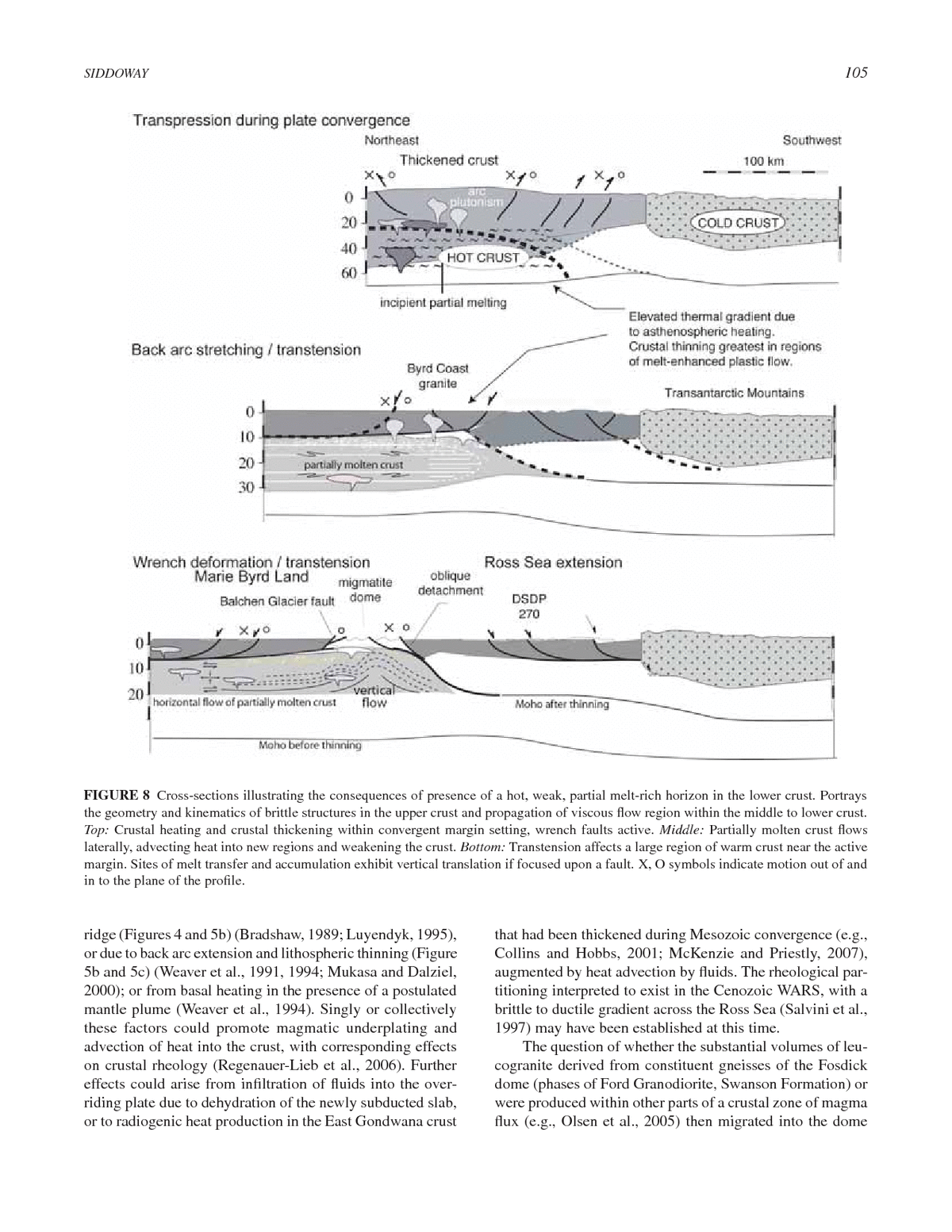
SIDDOWAY 105 FIGURE 8 Cross-sections illustrating the consequences of presence of a hot, weak, partial melt-rich horizon in the lower crust. Portrays the geometry and kinematics of brittle structures in the upper crust and propagation of viscous ï¬ow region within the middle to lower crust. Top: Crustal heating and crustal thickening within convergent margin setting, wrench faults active. Middle: Partially molten crust ï¬ows laterally, advecting heat into new regions and weakening the crust. Bottom: Transtension affects a large region of warm crust near the active margin. Sites of melt transfer and accumulation exhibit vertical translation if focused upon a fault. X, O symbols indicate motion out of and in to the plane of the proï¬le. ridge (Figures 4 and 5b) (Bradshaw, 1989; Luyendyk, 1995), that had been thickened during Mesozoic convergence (e.g., or due to back arc extension and lithospheric thinning (Figure Collins and Hobbs, 2001; McKenzie and Priestly, 2007), 5b and 5c) (Weaver et al., 1991, 1994; Mukasa and Dalziel, augmented by heat advection by ï¬uids. The rheological par- 2000); or from basal heating in the presence of a postulated titioning interpreted to exist in the Cenozoic WARS, with a mantle plume (Weaver et al., 1994). Singly or collectively brittle to ductile gradient across the Ross Sea (Salvini et al., these factors could promote magmatic underplating and 1997) may have been established at this time. advection of heat into the crust, with corresponding effects The question of whether the substantial volumes of leu- on crustal rheology (Regenauer-Lieb et al., 2006). Further cogranite derived from constituent gneisses of the Fosdick effects could arise from inï¬ltration of ï¬uids into the over- dome (phases of Ford Granodiorite, Swanson Formation) or riding plate due to dehydration of the newly subducted slab, were produced within other parts of a crustal zone of magma or to radiogenic heat production in the East Gondwana crust ï¬ux (e.g., Olsen et al., 2005) then migrated into the dome
106 ANTARCTICA: A KEYSTONE IN A CHANGING WORLD FIGURE 9 Development of the WARS in three hypothesized stages, based on the observations of strain accommodated upon wrench and extensional fault systems in Marie Byrd Land, a part of the WARS that resides above sea level. Basement graben conï¬gura- tion based on Cooper et al. (1991b) and Trey et al. (1997). (A) 130 Ma to 100 Ma, interpreted conï¬guration of the East Gondwana margin. HT metamorphism and crustal melting (ellipse symbol) is contemporaneous with arc magmatism at inboard sites including Fiordland (F); Paparoa complex in Western Province, NZ (WP); and Fosdick Mountains gneiss dome in MBL. Diachroneity of calcalkaline plutonism in the Median Batholith and Amundsen province may be a reï¬ection of subducted slab geometry or the conï¬guration of the Phoenix-Paciï¬c spreading ridge offshore (Fig- ures 3 and 5). Sites of alkalic magmatism may be an expression of dilational jogs in wrench zones or within detachment structures. TAS = Tasmania; EP = Eastern Province, NZ; CR = Chatham Rise; TI = Thurston Island. (B) 100-90 Ma, major phase of intracontinental deformation in the WARS. Tensile dike arrays and alkalic plutons were emplaced across the back-arc region. Blue shaded areas are gravity anomalies corresponding with high-density material along basin axes (Cooper et al., 1991b). Differential movement upon steep wrench zones is recorded by 40Ar/39Ar and AFT data that record rapid cooling between 97 Ma and 90 Ma for fault zone samples (Table 1). Based on the available data there appears to be an age progression from northeast toward southwest, with site DSDP 270 in the Ross Sea recording the youngest of the older subset of cooling ages, if the dominant population is accepted as the AFT cooling age (Fitzgerald and Baldwin, 1997). Dominant wrench deformation is documented in Marie Byrd Land, and prevalent normal faulting is inferred in the Ross Sea. The regional strain variation may be due to contrasts in competency of the pre-Mesozoic continental lithosphere, contrast- ing thermal conditions arising from lithospheric thinning or the dynamics of the convergent plate boundary (e.g., Figure 8), or the transition from a region undergoing oblique subduction of young continental lithosphere (eastern WARS) to one experiencing slow rifting between mature continental crust of Antarctica-Australia (western WARS). (C) Ca. 80 Ma, the time of breakup between WANT and NZ- Campbell Plateau. Continental extension across the WARS and Campbell Plateau exceeded 100 percent and was completed prior to onset of seaï¬oor spreading. Blue shaded areas are gravity anomalies corresponding with high-density material along basin axes; red areas are bathymetric (and basement) highs (Cooper et al., 1991b). Extension direction for breakup was nearly orthogonal to that for WARS opening and the rifted margin cuts at a high angle across Ross Sea basins (Lawver and Gahagan, 1994). It is probable that a preexisting wrench fault structure was reactivated at the time of breakup. This would explain the exceptionally abrupt ocean-con- tinent boundary along the coast of Marie Byrd Land (Gohl, 2008, this volume).
SIDDOWAY 107 upon structurally controlled pathways, is being addressed by 2004b), suggests that a crustal to lithospheric-scale discon- isotopic and geochemical investigation. A petrogenetic link tinuity has a role in gneiss dome emplacement. between Ford Granodiorite (source) and Byrd Coast granite The predominance of subhorizontal fabrics (rather than (product) has been demonstrated in the region (Weaver et al., vertical geometry expected for strike slip faults in the brittle 1991; Pankhurst et al., 1998). New Nd isotope data from the upper crust) is considered to be either (1) an expression of Fosdick Mountains strengthen this interpretation (Saito et al., coupling between crustal layers of contrasting compentency 2007). Therefore it is plausible that regional melting of Ford (e.g., metatexite versus diatexite plus leucogranite) that Granodiorite contributed to anatectic granite magmas that accommodates strain by different mechanisms (e.g., Tikoff were capable of vertical or lateral migration during oblique et al., 2002), or (2) accentuation of vertical shortening at the convergence (Weaver et al., 1995) to transtension (Siddoway âmelt propagation frontâ for melt-rich diatexite-leucogranite et al., 2005) along the Early Cretaceous plate margin. as melt-rich material migrated upward and was arrested at HT metamorphism and exhumation of deep crustal the thermal or permeability boundary (e.g., Sawyer, 2001) rocks on detachment structures are documented over a wide represented by metatexite (Figure 8) or (3) a change in ori- region proximal to the Gondwana margin arc in New Zealand entation of the shortening axis of strain due to unrooï¬ng, to and MBL (Kimbrough and Tulloch, 1989; Fitzgerald and coincide with direction of gravitational load. Baldwin, 1997; Forster and Lister, 2003; Siddoway et al., 2004b; Kula et al., 2007), suggesting pervasive middle to Overview of the West Antarctic Rift System lower crustal ï¬ow and advection of magmatic heat (Ehlers, 2005) over a large region (Figures 8 and 9). The existing Structural and geochronological data from sites throughout geochronological and thermochronological data reviewed the eastern WARS show a broad compatibility with respect above suggest a comparatively short and dynamic develop- to ENE coordinates for principal ï¬nite strain and timing of ment of the Fosdick gneiss dome and other strike slip shear crustal thinning deformation at ca. 105-95 Ma. The kine- zones active in the eastern WARS in Cretaceous time. U-Pb matic compatibility between structures of the brittle upper SHRIMP zircon data indicate that HT metamorphism was in and viscous lower crust is a great aid to interpretation of the effect by 140 Ma and growth of new igneous zircon within mechanisms of formation of the WARS. The best-exposed, the anatectic granites was under way by 115 Ma (Figure 6) crustal-scale structure with lateral extent in Marie Byrd (Siddoway et al., 2006); a possible indication that crustal Land is the South Fosdick detachment fault, which accom- melting and conditions favorable for viscous ï¬ow arose dur- modated dextral normal oblique translation of a pervasively ing convergent tectonism and crustal thickening along the brittlely deformed hanging wall block to the SW and WSW East Gondwana active margin. kinematic sense (dip dependent) along a mean direction of In the Fosdick Mountains gneiss dome syn- to post- 240° (McFadden et al., 2007). The transport direction agrees tectonic granite intrusions of 107 Ma to 96 Ma age delimit with stretching axes at deeper levels within the Fosdick the duration of detachment tectonics and exhumation, with dome, determined to be 060-240 to 070-250 (Siddoway et upward translation through ductile to brittle conditions and al., 2004b). development of a mylonitic shear zone at the transition Structural data that support an ENE direction for the (McFadden et al., 2007). Following the emplacement of the maximum principle ï¬nite strain axis for the Ford Ranges dome, mid-crustal magmatism and ï¬ow ceased and dome (Figure 4) include the regional maï¬c dike array (Siddoway rocks cooled rapidly from >700°C to <200°C at rates as high et al., 2005); mapped and inferred NW-SE dip-slip normal as 70°C/m.y. (Richard et al., 1994). Overprinting textures of faults in the southern Ford Ranges; and brittle kinematic cri- cordierite possibly record decompression of footwall rocks teria on ESE-striking dextral oblique minor faults and on NE- due to translation upon the detachment structure; and the striking sinistral shear fractures. Among mesoscopic brittle late-tectonic melt-ï¬lled, normal-sense shear bands that cut structures on land, strike slip faults are prevalent, forming all older structures may be an indication of a small volume of populations that accommodated both dextral and sinistral late leucogranite formed by decompression-induced melting motion (Figure 4). Mutually crosscutting relationships with (Siddoway et al., 2004b; Korhonen et al., 2007b). The very alkalic dikes indicate that the strike slip faults were active high rates of cooling recorded by 40Ar/39Ar mineral cooling during the 070-250-directed opening that is recorded by the data are comparable to rates of advective heat loss that arise maï¬c dike array. Regional mapping indicates that Byrd Coast from pluton emplacement in cold country rock (Fayon et plutons are spatially associated with inferred major faults and al., 2004). These observations are possible indications of a may occupy releasing bends (Figures 4 and 9). component of upward, gravity-driven ï¬ow (diapirism) during Consequently, the dextral and sinistral regional-scale emplacement of the dome (e.g., Teyssier and Whitney, 2002). faults in western Marie Byrd Land are viewed as contem- The association of the Fosdick Mountains gneiss dome with poraneous conjugate structures whose motion aided ENE- the Balchen Glacier fault, which is known to be an inherited WSW dextral transtension in the eastern WARS (Figure 4). Paleozoic structure (Richard et al., 1994; Siddoway et al., Kinematics of normal faults mapped offshore of Edward VII Peninsula (Luyendyk et al., 2001) are consistent, as is
108 ANTARCTICA: A KEYSTONE IN A CHANGING WORLD the direction of margin-parallel divergence across a short- CONCLUSIONS lived MBL-Bellingshausen plate boundary further east The determination of dextral transtensional strain in the (Heinemann et al., 1999). The stretching direction for the eastern WARS in Marie Byrd Land is consistent with the eastern WARS in MBL is generally parallel to that predicted current picture of tectonic plate interactions at the Phoenix- from the orientation and geometry of basement grabens in the East Gondwana (Paciï¬c sector) boundary, with the ï¬nal Ross Sea (Cooper et al., 1991a, 1997; Davey and Brancolini, stages of subduction marked by oblique convergence of 1995; Trey et al., 1997). The documentation of important young oceanic crust (Bradshaw, 1989; Luyendyk et al., 1995; wrench deformation in MBL supports past interpretations of Sutherland and Hollis, 2001; Wandres and Bradshaw, 2005), wrench and transfer faults within the WARS (e.g., Grindley as far east as Palmer Land (Figure 3) (Vaughan and Storey, and Davey, 1982) and for the ï¬rst time determines their ori- 2000; Vaughan et al., 2002b). It is now clear that strike slip entation and kinematics. fault systems, thought to be in existence during oblique The apparent change from prevalent normal faults in convergence at the Early Cretaceous margin (Weaver et al., the Ross Sea portion of the rift (Cooper et al., 1991a,b; 1995), remained active and accommodated intracontinental Tessensohn and Wörner, 1991) to dextral strike slip in the örner, rner, extension in the WARS until ca. 90 Ma. The structural and eastern WARS implies a rotation of principal stress axes from thermochronology record from MBL and the eastern Ross 1 vertical in the west to 2 vertical in the east. The spatial Sea indicates that the intracontinental extension between variation in kinematics and dynamics across the WARS prob- EANT and WANT that brought about opening the WARS by ably is related to the geometry of subducted lithosphere at 90 Ma is distinct from the NZ-WANT breakup at 83 Ma and the active margin (e.g., Bradshaw, 1989; Luyendyk, 1995), later. There is compelling evidence that the sharp continent- or is an expression of a regional strain gradient between ocean boundary that distinguishes the MBL margin from the the East Gondwana convergent boundary and the Australia- other gradational continent boundaries of the Antarctic Plate Antarctica boundary, undergoing slow divergence since ca. (Gohl, 2008, this volume) is controlled by a wrench zone 125 Ma (Cande and Mutter, 1982; Tessensohn and Wörner, örner, rner, formed during opening of the WARS. 1991). It may be that relict subvertical transcurrent zones pen- The conjugate wrench zones active in MBL between etrating to the base of the crust provide a deep-seated conduit 107 Ma and 97 Ma indicate a vertical orientation for the for magmatism in the linear volcanic mountain ranges of intermediate axis of principle ï¬nite strain, with axis of the MBL volcanic province (LeMasurier and Rex, 1989), or minimum ï¬nite strain oriented NW-SE in the plane of the control the deep narrow lineaments in the subglacial topog- earth. Transcurrent strain in MBL is consistent with the raphy beneath the Pine Island and Thwaites ice streams, oblique convergence vector (Figures 9a and 9b) deter- 950 km to the east (Holt et al., 2006; Vaughan et al., 2006). mined for Late Cretaceous time (Vaughan and Storey, In this way the lithospheric-scale structures formed during 2000; Sutherland and Hollis, 2001; Vaughan et al., 2002a). development of the West Antarctic rift system continue to Therefore, the postulated tectonic boundary separating the exert fundamental inï¬uences on the long-term continental Ross continental province from the Amundsen arc province evolution of West Antarctica. (Pankhurst et al., 1998) probably corresponds to an intrac- ontinental dextral transform fault. The Amundsen province boundary is inferred on paleomagnetic grounds to have ACKNOWLEDGMENTS an approximately E-W trend in Marie Byrd Land (Figure Sincere thanks are extended to J. D. Bradshaw, F. J. Davey, 9b) (DiVenere et al., 1996). Restoration of dextral motion and F. Tessensohn who provided reviews; to A. K. Cooper for across an E-W transform fault potentially would place the his dedicated service as editor; and to the ISAES 2007 pro- Amundsen province magmatic arc outboard of the Ford gram committee for inviting this contribution. M. Brown and Ranges (Figure 9a). Such a reconstruction helps explain the N. Mortimer provided input on a prior manuscript. Interpreta- extent and degree of regional heating throughout the Ross tions represented here have arisen through collaborations with province that elevated crustal isotherms (Figure 5b and 5c), B. P. Luyendyk, C. M. Fanning, R. McFadden, C. Teyssier, induced extensive mid-crustal ï¬ow of the type documented D. L. Whitney, C. A. Ricci, D. Wilson, F. J. Korhonen, and in the Fosdick Mountains (Figure 8c), promoted rapid S. Saito. Other contributors include the Support Ofï¬ce for intracontinental extension across the WARS, and prevented Aerogeophysical Research (SOAR) (1998), A. Whitehead, development of orogenic topography. Dynamic subduction L. Sass III, S. Kruckenberg, J. Haywood, S. Fadrhonc, and (e.g., Giunchi et al., 1996) or a postulated mantle plume M. Siddoway. Mike Roberts (polar guide), Raytheon Polar (Weaver et al., 1994; Storey et al., 1999) may have been Services, the 109th Air National Guard, and Kenn Borek Air responsible for preventing dramatic subsidence and volumi- provided logistical support over several years. Warm thanks nous inï¬lling of sedimentary basins of the Ross Sea (Wilson are also due to GANOVEX VII (1992-1993); Spedizione et al., 1998; Luyendyk et al., 2001; Karner et al., 2005). X, Italiantartide (1996-1997); J. Müller; and members of
SIDDOWAY 109 the South Paciï¬c Rim Tectonics Expedition (SPRITE). S. Bradshaw, J. D., B. Andrew, and B. D. Field. 1983. Swanson Formation and Borg and J. Palais are thanked for program leadership. The related rocks of Marie Byrd Land and a comparison with the Robertson Bay Group of northern Victoria Land. In Antarctic Earth Science, eds. U.S. National Science Foundation provided support through R. L. Oliver, P. R. James, J. B. Jago, pp. 274-279. Canberra: Australian grants OPP-0338279, 0443543, 9702161, and 9615282. The Academy of Science. content of the article is the work of the author and does not Bradshaw, J. D., R. J. Pankhurst, S. D. Weaver, B. C. Storey, R. J. Muir, necessarily reï¬ect the views of the National Science Foun- and T. R. Ireland. 1997. New Zealand superterranes recognized in Marie dation. Colorado College faculty research awards provided Byrd Land and Thurston Island. In The Antarctic Region, Geological Evolution and Processes, ed. C. A. Ricci, pp. 429-436. Siena: Terra further support. Antartica Publication. Brown, M. 1973. The deï¬nition of metatexis, diatexis, and migmatite. Proceedings of the Geologistsâ Association 84:371-382. REFERENCES Brown, M. 2007. Crustal melting and melt extraction, ascent and emplace- Adams, C. J. 1986. Geochronological studies of the Swanson Formation ment in orogens: Mechanisms and consequences. Journal of the Geo- of Marie Byrd Land, West Antarctica, and correlation with northern logical Society of London 164:709-730. Victoria Land, East Antarctica and the South Island, New Zealand. New Brown, M., and R. A. Pressley. 1999. Crustal melting in nature: Prosecut- Zealand Journal of Geology and Geophysics 29:345-358. ing source processes. Physics and Chemistry of the Earth, Part A: Solid Adams, C. J. 1987. Geochronology of granite terranes in the Ford Ranges, Earth and Geodesy 24:305-316. Marie Byrd Land, West Antarctica. New Zealand Journal of Geology Cande, S. C., and J. C. Mutter. 1982. A revised identiï¬cation of the oldest and Geophysics 30:51-72. sea-ï¬oor spreading anomalies between Australia and New Zealand. Adams, C. J. 2004. Rb-Sr age and strontium isotopic characteristics of Earth and Planetary Science Letters 58(2):151-160. the Greenland Group, Buller terrane, New Zealand, and correlations Cape Roberts Science Team. 2000. Studies from the Cape Roberts Proj- at the East Gondwana margin. New Zealand Journal of Geology and ect; Ross Sea, Antarctica, Initial Report on CRP-3. Terra Antartica Geophysics 47:189-200. 7(1-2):185-209. Adams, C. J., D. Seward, and S. D. Weaver. 1995. Geochronology of Creta- Collins, W. J. 2002a. Nature of extensional accretionary orogens. Tectonics ceous granites and metasedimentary basement on Edward VII Peninsula, 21(4), doi:10.1029/2000TC001272. Marie Byrd Land, West Antarctica. Antarctic Science 7:265-277. Collins, W. J. 2002b. Hot orogens, tectonic switching, and creation of con- Adams, C. J., R. J. Pankhurst, R. Maas, and I. L. Millar. 2005. Nd and Sr tinental crust. Geology 30(6): 535-538. isotopic signatures of metasedimentary rocks around the South Paciï¬c Collins, W. J., and B. E. Hobbs. 2001. What caused the Early Silurian change margin and implications for their provenance. Geological Society of from maï¬c to silicic (S-type) magmatism in the eastern Lachlan Fold London Special Publication 246:113-141. Belt? Australian Journal of Earth Sciences 48:25-41. Behrendt, J. C. 1999. Crustal and lithospheric structure of the West Antarctic Cook, R. A., R. Sutherland, and H. Zhu. 1999. Cretaceous-Cenozoic Rift System from geophysical investigationsâa review. Global and Geology and Petroleum Systems of the Great South Basin, New Zea- Planetary Change 23:25-44. land. Lower Hutt, New Zealand: Institute of Geological and Nuclear Behrendt, J. C., W. E. LeMasurier, A. K., Cooper, F., Tessensohn, A. Trehu, Sciences. and D. Damaske. 1991. Geophysical Studies of the West Antarctic Rift Cooper, A. K., and F. J. Davey. 1985. Episodic rifting of Phanerozoic rocks System. Tectonics 10:1257-1273. in the Victoria Land Basin, western Ross Sea, Antarctica. Science Behrendt, J. C., D. D. Blankenship, C. A. Finn, R. E. Bell, R. E. Sweeney, 229:1085-1087. S. M. Hodge, and J. M. Brozena. 1994. Casertz aeromagnetic data Cooper, A. K., F. J. Davey, and J. C. Behrendt. 1991a. Structural and deposi- reveal Late Cenozoic ï¬ood basalts (?) in the West Antarctic Rift System. tional controls on Cenozoic and (?)Mesozoic strata beneath the western Geology 22:527-530. Ross Sea. In Geological Evolution of Antarctica, eds. M. R. A. Thomson, Behrendt, J. C., R. Saltus, D. Damaske, A. McCafferty, C. A. Finn, D. J. A. Crame, J. W. Thomson, pp. 279-283. Cambridge: Cambridge Uni- Blankenship, and R. E. Bell. 1996. Patterns of late Cenozoic volcanic versity Press International. and tectonic activity in the West Antarctic rift system revealed by aero- Cooper, A. K., F. J. Davey, and K. Hinz. 1991b. Crustal extension and origin magnetic surveys. Tectonics 15:660-676. of sedimentary basins beneath the Ross Sea and Ross Ice Shelf, Ant- Bell, R. E., D. D. Blankenship, C. A. Finn, D. L. Morse, T. A. Scambos, J. arctica. In Geological Evolution of Antarctica, eds. M. R. A. Thomson, M. Brozena, and S. M. Hodge. 1998. Inï¬uence of subglacial geology on J. A. Crame, and J. W. Thomson, pp. 285-291. Cambridge: Cambridge the onset of a West Antarctic ice stream from aerogeophysical observa- University Press. tions. Nature 394:58-62. Cooper, A. K., H. Trey, G. Pellis, G. Cochrane, F. Egloff, M. Busetti, and Bialas, R. W., W. R. Buck, M. Studinger, and P. G. Fitzgerald. 2007. Plateau ACRUP Working Group. 1997. Crustal structure of the Southern Cen- collapse model for the Transantarctic Mountains-West Antarctic Rift tral Trough, Western Ross Sea. In The Antarctic Region: Geological System: Insights from numerical experiments. Geology 35:687-690. Evolution and Processes, ed. C. A. Ricci, pp. 637-642. Siena: Terra Blumenfeld, P., and J.-L. Bouchez. 1988. Shear criteria in granite and mig- Antartica Publication. matite deformed in the magmatic and solid state. Journal of Structural Cooper, R. A., and A. Tulloch. 1992. Early Paleozoic terranes in New Geology 10:361-372. Zealand and their relationship to the Lachlan Fold Belt. Tectonophysics Bradshaw, J. D. 1989. Cretaceous geotectonic patterns in the New Zealand 214:129-144. region. Tectonics 8:803-820. Dalziel, I. W. D. 1997. Neoproterozoic-Paleozoic geography and tectonics: Bradshaw, J. D. 2007. The Ross Orogen and Lachlan Fold Belt in Marie Review, hypothesis, environmental speculation. Geological Society of Byrd Land, Northern Victoria Land and New Zealand: Implication for America Bulletin 109:16-42. the tectonic setting of the Lachlan Fold Belt. In Antarctica: A Keystone Dalziel, I. W. D., B. C. Storey, S. W. Garrett, A. M. Grunow, L. D. B. Herrod, in a Changing WorldâOnline Proceedings for the Tenth International and R. J. Pankhurst. 1987. Extensional tectonics and the fragmentation Symposium on Antarctic Earth Sciences, eds. Cooper, A. K., C. R. of Gondwanaland. In Continental Extensional Tectonics, eds. M. P. Raymond et al., USGS Open-File Report 2007-1047. Short Research Coward, J. F. Dewey, and P. L. Hancock, Geological Society Special Paper 059, doi:10.3133/of2007-1047.srp059. Publication 28:433-441.
110 ANTARCTICA: A KEYSTONE IN A CHANGING WORLD Danesi, S., and A. Morelli. 2001. Structure of the upper mantle under the Fitzgerald, P. G., M. Sandiford, P. J. Barrett, and A. J. W. Gleadow. 1986. Antarctic Plate from surface wave tomography. Geophysical Research Asymmetric extension associated with uplift and subsidence in the Letters 28:4395-4398. Transantarctic Mountains and Ross Embayment. Earth and Planetary Davey, F. J., and G. Brancolini. 1995. The Late Mesozoic and Cenozoic Science Letters 81:67-78. structural setting of the Ross Sea region. In Geology and Seismic Stra- Ford, A. B., and P. J. Barrett. 1975. Basement rocks of the south-central Ross tigraphy of the Antarctic Margin, eds. A. K. Cooper, P. F. Barker, and Sea, Site 270, DSDP Leg 28. In Initial Reports of the Deep Sea Drilling G. Brancolini, Antarctic Research Series 68:167-182. Washington, D.C.: Project, eds. D. E. Hayes, I. A. Frakes et al. Washington, D.C.: U.S. American Geophysical Union. Government Printing Ofï¬ce, doi:10.2973/dsdp.proc.28.131.1975. Davey, F. J., and L. De Santis. 2006. A multi-phase rifting model for Forster, M. A., and G. S. Lister. 2003. Cretaceous metamorphic core com- the Victoria Land Basin, western Ross Sea, in Antarctica, Contribu- plexes in the Otago Schist, New Zealand. Australian Journal of Earth tions to Global Earth Sciences, eds. D. K. Fütterer, D. Damaske, G. Sciences 50:181-198. Kleinschmidt, H. Miller, and F. Tessensohn, pp. 303-308. Berlin: Foster, D. A., D. R. Gray, and Bucher, M. 1999. Chronology of deformation Springer. within the turbidite-dominated Lachlan orogen: Implications for the Decesari, R. C., C. C. Sorlien, B. P. Luyendyk, L. R. Bartek, J. B. Diebold, tectonic evolution of eastern Australia and Gondwana. Tectonics 18, and D. S. Wilson. 2003. Tectonic evolution of the Coulman High and doi:10.1029/1998TC900031. Central Trough along the Ross Ice Shelf, Southwestern Ross Sea, Ant- Gaffney, A. M., and C. S. Siddoway. 2007. Heterogeneous sources for Pleis- arctica. Eos Transactions American Geophysical Union, Fall Meeting tocene lavas of Marie Byrd Land, Antarctica: New Data from the SW Supplement, Abstract T12A-0447. Paciï¬c Diffuse Alkaline Magmatic Province. In Antarctica: A Keystone DiVenere, J., D. V. Kent, and I. W. D. Dalziel. 1996. Summary of palaeo- in a Changing WorldâOnline Proceedings for the Tenth International magnetic results from West Antarctica; implications for the tectonic Symposium on Antarctic Earth Sciences, eds. Cooper, A. K., C. R. evolution of the Paciï¬c margin of Gondwana during the Mesozoic. Raymond et al., USGS Open-File Report 2007-1047, Extended abstract In Weddell Sea Tectonics and Gondwana Break-up, eds. B. C. Storey, 063, http://pubs.usgs.gov/of/2007/1047/. E. C. King and R. A. Livermore, Geological Society Special Publica- Gaina, C., R. D. Müller, J.-Y. Royer, J. Stock, J. Hardebeck, and A. tion 108:31-43. Symonds. 1998. The tectonic history of the Tasman Sea: A puzzle with Eagles, G., K. Gohl, and R. D. Larter. 2004. High-resolution animated tectonic 13 pieces. Journal of Geophysical Research 103:12413-12433. reconstruction of the South Paciï¬c and West Antarctic Margin. Geochem- Gibson, G. M., and T. R. Ireland. 1995. Granulite formation during continen- istry Geophysics Geosystems 5:Q07002, doi:10.1029/2003GC000657. tal extension in Fiordland, New Zealand. Nature 375:479-482. Ehlers, T. A. 2005. Crustal thermal processes and the interpretation of Gibson, G. M., and T. R. Ireland. 1996. Extension of Delamerian (Ross) thermochronometer data. Reviews in Mineralogy and Geochemistry Orogen into western New Zealand; evidence from zircon ages and 58:315-350. implications for crustal growth along the Paciï¬c margin of Gondwana. Elliot, D. H., and T. H. Fleming. 2004. Occurrence and dispersal of magmas Geology 24:1087-1090. in the Jurassic Ferrar large igneous province, Antarctica. Gondwana Gibson, G. M., I. McDougall, and T. R. Ireland. 1988. Age constraints on Research 7(1):223-237. metamorphism and the development of a metamorphic core complex in Elliot, D. H., T. H. Fleming, P. Kyle, and K. A. Foland. 1999. Long-distance Fiordland, southern New Zealand. Geology 16:405-408. transport of magmas in the Jurassic Ferrar large igneous province, Ant- Giunchi, C., R. Sabadini, E. Boschi, and P. Gasperini. 1996. Dynamic arctica. Earth and Planetary Science Letters 167:89-104. models of subductionâGeophysical and geological evidence in the Fayon, A. K., D. L. Whitney, and C. Teyssier. 2004. Exhumation of oro- Tyrrhenian Sea. Geophysical Journal International 126:555-578. genic crust: Diapiric ascent versus low-angle normal faulting. In Gneiss Glen, R. A. 2005. The Tasmanides of eastern Australia. In Terrane Pro- Domes in Orogeny, eds. D. L. Whitney, C. Teyssier, and C. S. Siddoway, cesses at the Margin of Gondwana, eds. A. Vaughan, P. Leat, and Geological Society of America Special Paper 380:129-139. R. J. Pankhurst, Geological Society of London Special Publication Fergusson, C. L., and J. Coney. 1992. Implications of a Bengal fan-type 246:23-96. deposit in the Paleozoic Lachlan fold belt of southeastern Australia. Gohl, K. 2008, this volume. Antarcticaâs continent-ocean boundaries: Geology 20:1047-1049. Consequences for tectonic reconstructions. In Antarctica: A Keystone Fergusson, C. L., R. A. Henderson, I. Withnall, C. M. Fanning, D. Phillips, in a Changing World, eds. A. K. Cooper et al. Washington, D.C.: The and K. Lewthwaite. 2007. Structural, metamorphic, and geochronologi- National Academies Press. cal constraints on alternating compression and extension in the Early Gray, D. R., and D. A. Foster. 2004. Tectonic evolution of the Lachlan Oro- Paleozoic Gondwanan Paciï¬c margin, northeastern Australia. Tectonics gen, southeast Australia: Historical review, data synthesis and modern 26(3):TC300. perspectives. Australian Journal of Earth Sciences 51(6):773-817. Ferraccioli, F., E. Bozzo, and D. Damaske. 2002. Aeromagnetic signatures Grindley, G. W., and F. J. Davey. 1982. The reconstruction of New Zealand, over western Marie Byrd Land provide insight into magmatic arc base- Australia and Antarctica. In Antarctic Geoscience, ed. C. Craddock, pp. ment, maï¬c magmatism and structure of the eastern Ross Sea rift ï¬ank. 15-26. Madison: University of Wisconsin Press. Tectonophysics 347:139-165. Grunow, A. M., D. V. Kent, and I. W. D. Dalziel. 1991. New paleomag- Finn, C. A., R. D. Müller, and K. S. Panter. 2005. A Cenozoic diffuse netic data from Thurston Island: Implications for the tectonics of West alkaline magmatic province (DAMP) in the southwest Paciï¬c with- Antarctica and Weddell Sea opening. Journal of Geophysical Research out rift or plume origin. Geochemistry Geophysics Geosystems 6, 96:17935-17954. doi:10.1029/2004GC000723. Hamilton, R. J., C. C. Sorlien, B. P. Luyendyk, L. R. Bartek, and S. A. Fitzgerald, P. G. 2002. Tectonics and landscape evolution of the Antarctic Henrys. 1998. Tectonic regimes and structural trends off Cape Roberts, plate since the breakup of Gondwana, with an emphasis on the West Antarctica. Terra Antartica 5(3):261-272. Antarctic Rift System and the Transantarctic Mountains. In Antarctica Hayes, D. E., and F. J. Davey. 1975. A geophysical study of the Ross Sea, at the Close of a Millennium, eds. J. A. Gamble, D. N. B. Skinner, and Antarctica. In Initial Reports of the Deep Sea Drilling Project, eds. D. E. S. Henry, pp. 453-469. Wellington: Royal Society of New Zealand. Hayes, L. A. Frakes et al. Washington, D.C.: U.S. Government Printing Fitzgerald, P. G., and S. L. Baldwin. 1997. Detachment fault model for the Ofï¬ce, doi:10.2973/dsdp.proc.28.134.1975. evolution of the Ross Embayment. In The Antarctic Region: Geologi- Heinemann, J., J. Stock, K. Clayton, S. Hafner, S. Cande, and C. Raymond. cal Evolution and Processes, ed. C. A. Ricci, pp. 555-564. Siena: Terra 1999. Constraints on the proposed Marie Byrd Land-Bellingshausen Antartica Publication. plate boundary from seismic reï¬ection data. Journal of Geophysical Research 104:25321-25330.
SIDDOWAY 111 Hoernle, K., F. Hauff, R. Werner, N. Mortimer, P. van den Bogaard, LeMasurier, W. E. 2008. Neogene extension and basin deepening in the West J. Geldmacher, and D. Garbe-Schoenberg. 2004. New insights into Antarctic rift inferred from comparisons with the East African rift and the origin and evolution of the Hikurangi oceanic plateau. Eos other analogs. Geology 36(3):247-250, doi:10.1130/G24363A.1. Transactions of the American Geophysical Union 85:401-406, LeMasurier, W. E., and D. C. Rex. 1989. Evolution of linear volcanic ranges doi:10.1029/2004EO410001. in Marie Byrd Land, West Antarctica. Journal of Geophysical Research, Hollis, J. A., G. L. Clarke, K. A. Klepeis, N. R. Daczko, and T. R. Ireland. B 94:7223-7236. 2004. The regional signiï¬cance of Cretaceous magmatism and meta- Li, Z. X., and C. M. Powell. 2001. An outline of the palaeogeographic morphism in Fiordland, New Zealand, from U-Pb zircon geochronology. evolution of the Australasian region since the beginning of the Neopro- Journal of Metamorphic Geology 22:607-627. terozoic. Earth-Science Reviews 53. Holt, J. W., D. D. Blankenship, D. L. Morse, D. A. Young, M. E. Peters, Lisker, F., and M. Olesch. 1998. Cooling and denudation history of west- S. D. Kempf, T. G. Richter, D. G. Vaughan, and H. F. J. Corr. 2006. ern Marie Byrd Land, Antarctica, based on apatite ï¬ssion-tracks. In New boundary conditions for the West Antarctic Ice Sheet: Subglacial Advances in Fission-Track Geochronology, eds. P. Van den haute and F. topography of the Thwaites and Smith glacier catchments. Geophysical De Corte, pp. 225-240. Dordrecht: Kluwer Academic Publishers. Research Letters 33:L09502, doi:10.1029/2005GL025561. Lister, G. S., M. Etheridge, and P. Symonds. 1991. Detachment models for Huerta, A. 2007. Byrd drainage system: Evidence of a Mesozoic West Ant- the formation of passive continental margins. Tectonics 10:1038-1064. arctic Plateau. In Antarctica: A Keystone in a Changing WorldâOnline Lowe, A. L., and J. B. Anderson. 2002. Reconstruction of the West Antarctic Proceedings for the Tenth International Symposium on Antarctic ice sheet in Pine Island Bay during the Last Glacial Maximum and its Earth Sciences, eds. Cooper, A. K., C. R. Raymond et al., USGS subsequent retreat history. Quaternary Science Reviews 21:1879-1897. Open-File Report 2007-1047, Extended Abstract 091, http://pubs.usgs. Luyendyk, B. 1995. Hypothesis for Cretaceous rifting of East Gondwana gov/of/2007/1047/. caused by subducted slab capture. Geology 23:373-376. Ireland, T. R., and G. M. Gibson. 1998. SHRIMP monazite and zircon Luyendyk, B. P., C. H. Smith, and F. M. van der Wateren. 1994. Glacia- geochronology of high-grade metamorphism in New Zealand. Journal tion, block faulting, and volcanism in western Marie Byrd Land. Terra of Metamorphic Geology 16:149-167. Antartica 1:541-543. Jokat, W., T. Boebel, M. König, and M. Uwe. 2003. Timing and geometry of Luyendyk, B., S. Cisowski, C. H. Smith, S. Richard, and D. Kimbrough. early Gondwana breakup. Journal of Geophysical Research 108:2428. 1996. Paleomagnetic study of the northern Ford Ranges, western Marie Karner, G. D., M. Studinger, and R. E. Bell. 2005. Gravity anomalies of Byrd Land, West Antarctica: Motion between West and East Antarctica. sedimentary basins and their mechanical implications: Application to Tectonics 15:122-141. the Ross Sea basins, West Antarctica. Earth and Planetary Science Luyendyk, B. P., C. C. Sorlien, D. S. Wilson, L. R. Bartek, and C. S. Letters 235:577-596. Siddoway. 2001. Structural and tectonic evolution of the Ross Sea Rift Kimbrough, D., and A. J. Tulloch. 1989. Early Cretaceous age of orthogneiss in the Cape Colbeck region, eastern Ross Sea, Antarctica. Tectonics from the Charleston Metamorphic Group, New Zealand. Earth and 20:933-958. Planetary Science Letters 95:130-140. Luyendyk, B. P., D. S. Wilson, and C. S. Siddoway. 2003. The eastern Korhonen, F. J., M. Brown, and C. S. Siddoway. 2007a. Petrologic and margin of the Ross Sea Rift in western Marie Byrd Land: Crustal struc- geochronological constraints on the polymetamorphic evolution of ture and tectonic development. Geochemistry Geophysics Geosystems, the Fosdick Migmatite Dome, Marie Byrd Land, West Antarctica. In doi:10.1029/2002GC000462. Antarctica: A Keystone in a Changing WorldâOnline Proceedings for Marrett, R., and R. W. Allmendinger. 1990. Kinematic analysis of fault-slip the Tenth International Symposium on Antarctic Earth Sciences, eds. data. Journal of Structural Geology 12:973-986. Cooper, A. K., C. R. Raymond et al., USGS Open-File Report 2007- Maule, C. F., M. E. Purucker, N. Olsen, and K. Mosegaard. 2005. Heat ï¬ux 1047, Extended abstract 049, http://pubs.usgs.gov/of/2007/1047/. anomalies in Antarctica revealed by satellite magnetic data. Science Korhonen, F. J., M. Brown, and C. S. Siddoway. 2007b. Unraveling poly- 309:464-467. phase high-grade metamorphism and anatexis in the Fosdick migmatite McAdoo, D., and S. Laxon. 1997. Antarctic tectonics: Constraints from an dome, West Antarctica, using mineral equilibria modeling and in situ ERS-1 satellite marine gravity ï¬eld. Science 276:556-561. monazite geochronology. Eos Transactions of American Geophysical McFadden, R., C. S. Siddoway, C. Teyssier, C. M. Fanning, and S. C. Union, Fall Meeting Supplement 88, Abstract V04-4536. Kruckenberg. 2007. Cretaceous oblique detachment tectonics in the Fos- Kula, J., A. J. Tulloch, T. L. Spell, and M. L. Wells. 2007. Two-stage rifting dick Mountains, Marie Byrd Land, Antarctica. In Antarctica: A Keystone of Zealandia-Australia-Antarctica: Evidence from 40Ar/39Ar thermochro- in a Changing WorldâOnline Proceedings for the Tenth International nometry of the Sisters shear zone, Stewart Island, New Zealand. Geology Symposium on Antarctic Earth Sciences, eds. Cooper, A. K., C. R. 35:411-414, doi:10.1130/G23432A.1. Raymond et al., USGS Open-File Report 2007-1047. Short Research Laird, M. G., and J. D. Bradshaw. 2004. The break-up of a long-term rela- Paper 046, doi:10.3133/of2007-1047.srp046. tionship: The Cretaceous separation of New Zealand from Gondwana. McKenzie, D., and K. Priestley. 2007. The influence of lithospheric Gondwana Research 7:273-286. thickness variations on continental evolution. Lithos, doi:10.1016/ Larter, R. D., A. P. Cunningham, F. Barker, K. Gohl, and F. O. Nitsche. j.lithos.2007.05.005. 2002. Tectonic evolution of the Paciï¬c margin of Antarctica. 1. Late Milord, I., E. W. Sawyer, and M. Brown. 2001. Formation of diatexite Cretaceous tectonic reconstructions. Journal of Geophysical Research migmatite and granite magma during anatexis of semi-pelitic metasedi- 107:2345. mentary rocks: An example from St. Malo, France. Journal of Petrology Lawrence, J. F., D. A. Wiens, A. A. Nyblade, S. Anandakrishnan, J. Shore, 42:487-505. and D. Voigt. 2006. Upper mantle thermal variations beneath the Trans- Morand, V. J. 1990. Low-pressure regional metamorphism in the Omeo antarctic Mountains inferred from teleseismic S-wave attenuation. Geo- Metamorphic Complex, Victoria, Australia. Journal of Metamorphic physical Research Letters 33:L03303, doi:10.1029/2005GL024516. Geology 8:1-12. Lawver, L. A., and L. M. Gahagan. 1994. Constraints on the timing of exten- Mortimer, N. 2004. Basement gabbro from the Lord Howe Rise. New Zea- sion in the Ross Sea region. Terra Antartica 1:545-552. land Journal of Geology and Geophysics 47:501-507. LeMasurier, W. E., and C. A. Landis. 1996. Mantle-plume activity recorded Mortimer, N., A. J. Tulloch, R. N. Spark, N. W. Walker, E. Ladley, by low relief erosion surfaces in West Antarctica and New Zealand. Bul- A. Allibone, and D. L. Kimbrough. 1999a. Overview of the Median letin of the Geological Society of America 108:1450-1466. Batholith, New Zealand: A new interpretation of the geology of the Median Tectonic Zone and adjacent rocks. Journal of African Earth Sciences 29:257-268.
112 ANTARCTICA: A KEYSTONE IN A CHANGING WORLD Mortimer, N., B. Gans, A. Calvert, and N. W. Walker. 1999b. Geology Rossetti, F., F. Lisker, F. Storti, and A. L. Läufer. 2003b. Tectonic and and geochronometry of the east edge of the Median Batholith (Median denudational history of the Rennick Graben, North Victoria Land: Impli- Tectonic Zone): A new perspective on Permian to Cretaceous crustal cations for the evolution of rifting between East and West Antarctica. growth of New Zealand. The Island Arc 8:404-425. Tectonics 22(2):1016, doi:10.1029/2002TC001416, 2003. Mortimer, N., K. Hoernle, F. Hauff, J. M. Palin, W. J. Dunlap, R. Werner, Rossetti, F., F. Tecce, L. Aldega, M. Brilli, and C. Faccenna. 2006. Deforma- and K. Faure. 2006. New constraints on the age and evolution of tion and ï¬uid ï¬ow during orogeny at the palaeo-Paciï¬c active margin of the Wishbone Ridge, southwest Paciï¬c Cretaceous microplates, and Gondwana: The Early Palaeozoic Robertson Bay accretionary complex Zealandia-West Antarctica breakup. Geology 3:185-188. (north Victoria Land, Antarctica). Journal of Metamorphic Geology Muir, R., T. R. Ireland, S. D. Weaver, and J. D. Bradshaw. 1994. Ion 24:33-53. microprobe U-Pb zircon geochronology of granitic magmatism in the Saito, S., F. Korhonen, M. Brown, and C. S. Siddoway. 2007. Petrogenesis Western Province of the South Island, New Zealand. Chemical Geology of granites in the Fosdick migmatite dome, Marie Byrd Land, West 113:171-189. Antarctica. In Antarctica: A Keystone in a Changing WorldâOnline Muir, R. J., S. D. Weaver, J. D. Bradshaw, G. N. Eby, and J. A. Evans. 1995. Proceedings for the Tenth International Symposium on Antarctic The Cretaceous Separation Point Batholith, New Zealand; granitoid Earth Sciences, eds. Cooper, A. K., C. R. Raymond et al., USGS magmas formed by melting of maï¬c lithosphere. Journal of Geological Open-File Report 2007-1047. Extended Abstract 105, http://pubs.usgs. Society of London 152:689-701. gov/of/2007/1047/. Muir, R. J., T. R. Ireland, S. D. Weaver, and J. D. Bradshaw. 1996. Ion Salvini, F., G. Brancolini, M. Busetti, F. Storti, F. Mazzarini, and F. Coren. microprobe dating of Paleozoic granitoids: Devonian magmatism in 1997. Cenozoic geodynamics of the Ross Sea region, Antarctica: Crustal New Zealand and correlations with Australia and Antarctica. Chemical extension, intraplate strike-slip faulting, and tectonic inheritance. Jour- Geology 127:191-210. nal of Geophysical Research 102:24669-24696. Muir, R. J., T. R. Ireland, S. D. Weaver, J. D. Bradshaw, T. E. Waight, Sawyer, E. W. 1998. Formation and evolution of granite magmas during R. Jongens, and G. N. Eby. 1997. SHRIMP U-Pb geochronology of crustal reworking: The signiï¬cance of diatexites. Journal of Petrology Cretaceous magmatism in northwest Nelson-Westland, South Island, 39:1147-1167. New Zealand. New Zealand Journal of Geology and Geophysics Sawyer, E. W. 2001. Melt segregation in the continental crust: Distribution 40:453-463. and movement of melt in anatectic rocks. Journal of Metamorphic Muir, R., T. R. Ireland, S. D. Weaver, J. D. Bradshaw, J. A. Evans, G. N. Eby, Geology 19:291-309. and D. Shelley. 1998. Geochronology and geochemistry of a Mesozoic Sawyer, E. W. 2004. Morphological variations in migmatites: importance magmatic arc system, Fiordland, New Zealand. Journal of the Geologi- of melt fraction and syn-migmatization strain. In Scientiï¬c Sessions: cal Society of London 155:1037-1053. Abstracts (part 1), 32nd International Geological Congress, Florence, Mukasa, S. B., and I. W. D. Dalziel. 2000. Marie Byrd Land, West Antarc- Italy, 2004, Abstract 86-9, p. 423. tica: Evolution of Gondwanaâs Paciï¬c margin constrained by zircon Scott, J. M., and A. F. Cooper. 2006. Early Cretaceous extensional U-Pb geochronology and feldspar common-Pb isotopic compositions. exhumation of the lower crust of a magmatic arc: Evidence from Bulletin of the Geological Society of America 112:611-627. the Mount Irene Shear Zone, Fiordland, New Zealand. Tectonics 25, Olsen, S. N., B. D. Marsh, and L. P. Baumgartner. 2005. Modelling mid- doi.10.1029/2005TC001890. crustal migmatite terrains as feeder zones for granite plutons: The Siddoway, C. S., S. Baldwin, G. Fitzgerald, C. M. Fanning, and B. P. competing dynamics of melt transfer by bulk versus porous ï¬ow. Trans- Luyendyk. 2004a. Ross Sea mylonites and the timing of intracontinental actions of the Royal Society of Edinburgh, Earth Sciences 95:49-58. extension within the West Antarctic rift system. Geology 32:57-60. Pankhurst, R. J., S. D. Weaver, J. D. Bradshaw, B. C. Storey, and T. R. Siddoway, C. S., S. M. Richard, C. M. Fanning, and B. P. Luyendyk. Ireland. 1998. Geochronology and geochemistry of pre-Jurassic 2004b. Origin and emplacement of a middle Cretaceous gneiss dome, superterranes in Marie Byrd Land, Antarctica. Journal of Geophysical Fosdick Mountains, West Antarctica. In Gneiss Domes in Orogeny, eds. Research 103:2529-2547. D. L. Whitney, C. Teyssier, and C. S. Siddoway, Geological Society of Regenauer-Lieb, K., R. F. Wienberg, and G. Rosenbaum. 2006. The effects America Special Paper 380:267-294. of energy feedbacks on continental strength. Nature 442:67-70. Siddoway, C. S., L. C. Sass III, and R. Esser. 2005. Kinematic history of Richard, S. M., C. H. Smith, D. K. Kimbrough, G. Fitzgerald, B. P. Marie Byrd Land terrane, West Antarctica: Direct evidence from Creta- Luyendyk, and M. O. McWilliams. 1994. Cooling history of the ceous maï¬c dykes. In Terrane Processes at the Margin of Gondwana, northern Ford Ranges, Marie Byrd Land, West Antarctica. Tectonics eds. A. Vaughan, P. Leat and R. J. Pankhurst, Geological Society of 13:837-857. London Special Publication 246:417-438. Richards, S. W., and W. J. Collins. 2002. The Cooma Metamorphic Siddoway, C. S., C. M. Fanning, S. C. Kruckenberg, and S. C. Fadrhonc. Complex, a low-P, high-T (LPHT) regional aureole beneath the Mur- 2006. U-Pb SHRIMP investigation of the timing and duration of melt rumbidgee Batholith. Journal of Metamorphic Geology 20(1):119-134, production and migration in a Paciï¬c margin gneiss dome, Fosdick doi:10.1046/j.0263-4929.2001.00360.x. Mountains, Antarctica. Eos Transactions of the American Geophysical Ritzwoller, M. H., N. M. Shapiro, A. L. Levshin, and G. M. Leahy. 2001. Union, Fall Meeting Supplement 87, Abstract V23D-0661. Crustal and upper mantle structure beneath Antarctica and surrounding Sieminski, A., E. Debayle, and J. J. Leveque. 2003. Seismic evidence for oceans. Journal of Geophysical Research B 106:30645-30670. deep low-velocity anomalies in the transition zone beneath West Ant- Rocchi, S., P. Armienti, and G. Di Vincenzo. 2005. No plume, no rift mag- arctica. Earth and Planetary Science Letters 216:645-661. matism in the West Antarctic Rift. In Plates, Plumes, and Paradigms, Smith, C. H. 1992. Metapelitic migmatites at the granulite facies transition, eds. G. R. Foulger, J. Natland, D. Presnall and D. L. Anderson, Geologi- Fosdick Mountains, Antarctica. In Recent Progress in Antarctic Earth cal Society of America Special Paper 388:435-447. Science, eds. Y. Yoshida, K. Kaminuma, and K. Shiraishi, pp. 295-301. Rossetti, F., G. DiVincenzo, A. L. Läufer, F. Lisker, S. Rocchi, and Tokyo: Terra Publications. F. Storti. 2003a. Cenozoic right-lateral strike-slip faulting in North Smith, C. H. 1996. Migmatites of the Alexandra Mountains, West Antarc- Victoria Land: An integrated structural, AFT and 40Ar-39Ar study. In 9th tica: Pressure-temperature conditions of formation and regional context. International Symposium on Antarctic Earth SciencesâAntarctic Con- Geologisches Jahrbuch B 52:169-178. tributions to Global Earth Science, eds. D. K. Fütterer, D. Damaske, Smith, C. H. 1997. Mid-crustal processes during Cretaceous rifting, Fosdick G. Kleinschmidt, H. Miller and F. Tessensohn, pp. 283-284. Potsdam: Mountains, Marie Byrd Land. In The Antarctic Region: Geological Terra Nostra. Evolution and Processes, ed. C. A. Ricci, pp. 313-320. Siena: Terra Antartica Publication.
SIDDOWAY 113 Sorlien, C. C., B. P. Luyendyk, D. S. Wilson, R. C. Decesari, L. R. Bartek, Trey, H., A. K. Cooper, G. Pellis, B. della Vedova, G. Cochrane, G. and J. B. Diebold. 2007. Oligocene development of the West Antarctic Brancolini, and J. Makris. 1999. Transect across the West Antarctic rift Ice Sheet recorded in eastern Ross Sea strata. Geology 35:467-470. system in the Ross Sea, Antarctica. Tectonophysics 301:61-74. Spell, T. L., I. McDougall, and A. J. Tulloch. 2000. Thermochronological Tulloch, A. J., and D. L. Kimbrough. 1989. The Paparoa metamorphic core constraints on the breakup of the Paciï¬c Gondwana margin: The Papa- complex, New Zealand: Cretaceous extension associated with fragmen- roa metamorphic core complex, South Island, New Zealand. Tectonics tation of the Paciï¬c margin of Gondwana. Tectonics 8:1217-1234. 19:433-451. Tulloch, A. J., and D. L. Kimbrough. 2003. Paired plutonic belts in conver- Squire, R. J., I. H. Campbell, C. M. Allen, and C. J. L. Wilson. 2006. Did gent margins and the development of high Na, Al, Sr, low Y magmatism: the Transgondwanan Supermountain trigger the explosive radiation of The Peninsular Ranges Batholith of California and the Median Batholith animals on Earth? Earth and Planetary Science Letters 250:116-133. of New Zealand. Geological Society of America Special Publication Stern, T., and U. S. ten Brink. 1989. Flexural uplift of the Transantarctic 374:275-295. mountains. Journal of Geophysical Research 94:10315-10330. Tulloch, A. J., D. Kimbrough, D., and R. Wood. 1991. Carboniferous Stock, J. M., and S. C. Cande. 2002. Tectonic history of Antarctic seaï¬oor granite basement dredged from a site on the southwest margin of the in the Australia-New Zealand-South Paciï¬c sector: Implications for Challenger Plateau. New Zealand Journal of Geology and Geophysics Antarctic continental tectonics. In Antarctica at the Close of a Millen- 34:121-126. nium, eds. J. A. Gamble, D. N. B. Skinner and S. Henry, pp. 251-259. Vaughan, A. M., and R. A. Livermore. 2005. Episodicity of Mesozoic ter- Welllington: Royal Society of New Zealand. rane accretion along the Paciï¬c margin of Gondwana: Implications for Storey, B. C. 1991. The crustal blocks of West Antarctica within Gond- superplume-plate interactions. In Terrane Processes at the Margin of wana: Reconstruction and break-up model. In Geological Evolution of Gondwana, eds. A. Vaughan, P. Leat and R. J. Pankhurst, Geological Antarctica, eds. M. R. A. Thomson, J. A. Crame, and J. W. Thomson, Society of London Special Publication 246:143-178. pp. 587-592. Cambridge: Cambridge University Press. Vaughan, A. M., and B. C. Storey. 2000. The eastern Palmer Land shear Storey, B. C. 1992. Role of subduction-plate boundary forces during the zone: A new terrane accretion model for the Mesozoic development of initial stages of Gondwana break-up: Evidence from the proto-Paciï¬c the Antarctic Peninsula. Journal of the Geological Society of London margin of Antarctica. In Magmatism and the Causes of Continental 157:1243-1256. Breakup, eds. B. C. Storey, T. Alabaster, and R. J. Pankhurst, Geological Vaughan, A. M., S. P. Kelley, and B. C. Storey. 2002a. Age of ductile Society Special Publication 68:165-184. deformation on the Eastern Palmer Land Shear Zone, Antarctica, and Storey, B., T. Leat, S. D. Weaver, R. J. Pankhurst, J. D. Bradshaw, and implications for timing of Mesozoic terrane collision. Geological S. Kelley. 1999. Mantle plumes and Antarctica-New Zealand rifting: Magazine 139:465-471. Evidence from mid-Cretaceous maï¬c dykes. Journal of the Geological Vaughan, A. M., R. J. Pankhurst, and C. M. Fanning. 2002b. A mid- Society of London 156:659-671. Cretaceous age for the Palmer Land event, Antarctic Peninsula: Impli- Stump, E. 1995. The Ross Orogen of the Transantarctic Mountains: New cations for terrane accretion timing and Gondwana palaeolatitudes. York: Cambridge University Press. Journal of the Geological Society of London 159:113-116. Sutherland, R. 1999. Basement geology and tectonic development of the Vaughan, D. G., F. Ferraccioli, N. Frearson, H. F. J. Corr, A. OâHare, greater New Zealand region: An interpretation from regional magnetic D. Mach, J. W. Holt, D. D. Blankenship, D. L. Morse, and D. A. Young. data. Tectonophysics 308:341-362. 2006. New boundary conditions for the West Antarctic Ice Sheet: Sub- Sutherland, R., and C. Hollis. 2001. Cretaceous demise of the Moa plate and glacial topography beneath Pine Island Glacier. Geophysical Research strike-slip motion at the Gondwana margin. Geology 29:279-282. Letters 33:L09501, doi:10.1029/2005GL025588. Taylor, B. 2006. The single largest oceanic plateau: Ontong Java-Manihiki- Vernon, R. H., and S. E. Johnson. 2000. Transition from gneiss to migma- Hikurangi. Earth and Planetary Science Letters 241:372-380. tite and the relationship of leucosome to peraluminous granodiorite in ten Brink, U. S., R. I. Hackney, S. Bannister, T. A. Stern, and Y. Makovsky. the Cooma Complex, SE Australia. Journal of the Virtual Explorer 2. 1997. Uplift of the Transantarctic Mountains and the bedrock beneath http://virtualexplorer.com.au/special/meansvolume/contribs/vernon/ the East Antarctic ice sheet. Journal of Geophysical Research, Solid index.html. Earth 102:27603-27621. Wandres, A. M., and J. D. Bradshaw. 2005. New Zealand tectonostratigra- Tessensohn, F., and G. Wörner. 1991. The Ross Sea Rift System: Structure, phy and implications from conglomeratic rocks for the conï¬guration of evolution and analogues. In Geological Evolution of Antarctica, eds. the SW Paciï¬c margin of Gondwana. In Terrane Processes at the Margin M. R. A. Thomson, J. A. Crame, and J. W. Thomson., pp. 273-277. of Gondwana, eds. A. Vaughan, P. Leat and R. J. Pankhurst, Geological Cambridge: Cambridge University Press. Society of London Special Publication 246:179-216. Teyssier, C., and D. L. Whitney. 2002. Gneiss domes and orogeny. Geology Weaver, S. D., J. D. Bradshaw, and C. J. Adams. 1991. Granitoids of the 30:1139-1142. Ford Ranges, Marie Byrd Land, Antarctica. In Geological Evolution of Teyssier, C., E. Ferré, D. L. Whitney, B. Norlander, O. Vanderhaeghe, Antarctica, eds. M. R. A. Thomson, J. A. Crame, and J. W. Thomson, and D. Parkinson. 2005. Flow of partially molten crust and origin of pp. 345-351. Cambridge: Cambridge University Press. detachments during collapse of the Cordilleran orogen. In High-Strain Weaver, S. D., C. J. Adams, R. J. Pankhurst, and I. L. Gibson. 1992. Granites Zones: Structure and Physical Properties, eds. D. Bruhn and L. Burlini. of Edward VII Peninsula, Marie Byrd Land: Anorogenic magmatism Geological Society of London Special Publication 245:39-64. related to Antarctic-New Zealand rifting. In Proceedings of the Second Thompson, A. B. 1996. Fertility of crustal rocks during anatexis. Transac- Hutton Symposium on the Origin of Granites and Related Rocks, eds. tions of the Royal Society of Edinburgh 87:1-10. E. Brown and B. W. Chappell. Transactions of the Royal Society of Tikoff, B., C. Teyssier, and C. Waters. 2002. Clutch tectonics and the partial Edinburgh, Earth Sciences 83:281-290. attachment of lithospheric layers. EGU Stephan Mueller Special Pub- Weaver, S. D., B. C. Storey, R. J. Pankhurst, S. B. Mukasa, V. Divenere, and lication Series 1:57-73. J. D. Bradshaw. 1994. Antarctic-New Zealand rifting and Marie Byrd Trey, H., J. Makris, G. Brancolini, and A. K. Cooper. 1997. The Eastern Land lithospheric magmatism linked to ridge subduction and mantle Basin Crustal model from wide-angle reï¬ection data, Ross Sea, Ant- plume activity. Geology 22:811-814. arctica Structure of the Southern Central Trough, Western Ross Sea. In Weaver, S. D., R. J. Pankhurst, B. C. Storey, J. D. Bradshaw, and R. Muir. The Antarctic Region: Geological Evolution and Processes, ed. C. A. 1995. Cretaceous magmatism along the SW Paciï¬c Gondwana margin. Ricci, pp. 643-648. Siena: Terra Antartica Publication. In AbstractsâVII International Symposium on Antarctic Earth Sciences, ed. C. A. Ricci, p. 402. Siena: Terra Antartica Publication.
114 ANTARCTICA: A KEYSTONE IN A CHANGING WORLD Weinberg, R. F. 2006. Melt segregation structures in granitic plutons. Geol- Wilson, T. J. 1992. Mesozoic and Cenozoic kinematic evolution of the ogy 34:305-308. Transantarctic Mountains. In Recent Progress in Antarctic Earth Sci- Wilbanks, J. R. 1972. Geology of the Fosdick Mountains, Marie Byrd Land. ence, eds. Y. Yoshida, K. Kaminuma, and K. Shiraishi, pp. 303-314. In Antarctic Geology and Geophysics, ed. R. J. Adie, pp. 277-284. Oslo: Tokyo: Terra Scientiï¬c Publishing. Universitetsforlaget. Wilson, T. J. 1993. Jurassic faulting and magmatism in the Transantarctic Wilson, D., and B. P. Luyendyk. 2006. Bedrock platforms within the Ross Mountains; implications for Gondwana breakup. In Assembly, Evolution Embayment, West Antarctica: Hypotheses for ice sheet history, wave and Dispersal: Proceedings of the Gondwana Eight Symposium, eds. erosion, Cenozoic extension, and thermal subsidence. Geochemistry R. H. Findlay, R. Unrug, M. R. Banks and J. J. Veevers, pp. 563-572. Geophysics Geosystems 7(2):Q12011, doi:10.1029/2006GC001294. Hobart, Tasmania: International Gondwana Symposium. Wilson, G. S., A. P. Roberts, K. L. Verosub, F. Florindo, and L. Sagnotti. Winberry, J. P., and S. Anandakrishnan. 2004. Crustal structure of the 1998. Magnetobiostratigraphic chronology of the Eocene-Oligocene West Antarctic rift system and Marie Byrd Land hotspot. Geology transition in the CIROS-1 core, Victoria Land margin, Antarctica; impli- 32:977-980. cations for Antarctic glacial history. Bulletin of the Geological Society of America 110:35-47.
