
Appendix C
Details on Tracking and
Accounting by Bay Jurisdiction
DELAWARE
The following information was compiled from the watershed implementation plan (WIP; DE DNREC, 2010), responses to a committee questionnaire (J. Volk, DE DNREC, personal communication, 2010), and personal communication for factual corrections (E. Goldbaum, DE DNREC, personal communication, 2010).
1) Who is responsible for collecting, reporting, and verifying nutrient and sediment controls?
Point Source:
• Delaware currently uses the Permit Control System to track waste-water facility permitted loads (reported monthly through discharge monitoring reports) and will transition into the Integrated Compliance Information System (ICIS) that is transparent, accessible, and fully compatible with EPA decision tools.
Non-point source:
• Septic - Delaware Department of Natural Resources and Control (DNREC) uses the Environmental Navigator database to track all permitted septic systems, including licenses, service providers, site evaluations, permits, inspections, and violations, and includes GIS capability.
• Stormwater - Eight state and local government agencies inspect stormwater BMPs implemented and report to the CBP. Six out of the eight agencies store the information in an electronic database (Excel, Oracle,
Access, etc.), whereas two agencies have a paper data storage system. Changes to existing collection, report, and verification procedures are underway and will become statewide in the next few years. A new database, MudTracker, will be used to track post-development stormwater BMPs, resolving consistency issues for several jurisdictions. An Access database is in development to be used to track MS4 permits.
• Land use - DNREC tracks loads impacted by land-use change using two models, Nutrient Budget Protocol and Delaware Urban Runoff Management Model (DURMM).
• Agriculture - The Farm Service Agency (FSA) and the Natural Resources Conservation Service (NRCS) will report data through the USGS, which will then transfer the data to the Watershed Model. This system is not yet final, however; that data was submitted by the state to the CBP for the 2010 data submission. Additionally, other state-funded practices are issued and tracked through the Dept. of Agriculture, such as the manure relocation program and the nutrient management plan cost share program.
• Forest - Dept. of Agriculture tracks data on urban tree planting, afforestation, and forest harvesting practices.
2) Are the practices geo-referenced?
Non-point source:
• Septic - Septic systems are geo-referenced in the Environmental Navigator.
• Stormwater - All permanent stormwater BMPs being added to the MudTracker database used by DNREC, Kent Conservation District, and Sussex Conservation District are geo-referenced. Stormwater BMPs in the Chesapeake Bay drainage have been given the highest priority for input to MudTracker and is expected to be completed in 2011. In addition, New Castle County Special Services maintains its own database of stormwater BMPs, as does the Delaware Department of Transportation, which are also geo-referenced. This should provide over 90 percent coverage of the permanent stormwater BMPs in the Chesapeake by the end of 2011.
• Land use - DURMM and the Nutrient Load Protocol uses tax parcel identification numbers, which can be geo-referenced.
• Agriculture - Through an agreement between the FSA and the USGS (and a similar pending agreement between the NRCS and the USGS), cost-shared agricultural BMPs reported are aggregated by watershed and reported directly into the Bay model. Most of the state’s agricultural BMPs are reported through these two agencies, although it is unclear how many of BMPs cost-shared by other programs are geo-referenced.
• Forest - Yes, the Dept. of Agriculture geo-references BMPs and stores the data in shapefiles. The data is reported to DNREC’s 319 Program.
3) What are procedures for tracking and verifying that regulatory and contracted practices are properly designed, installed and maintained over the lifespan of the practice according to state/USDA practice standards?
• Septic - DNREC tracks groundwater discharges on site specific systems. There are routine annual inspections on systems larger than 2,500 gallons per day, and these systems must be operated by licensed operators. Delaware also requires owners of advanced treatment systems less than 2,500 gallons per day to enter into contract with a licensed service provider who inspects these systems twice a year and sends the inspection reports to DNREC annually. Conventional on-site systems less than 2,500 gallons per day are not required to be inspected. Delaware is in the process of revising our regulations to require these systems be inspected by a licensed Class H inspector at the time of sale statewide.
• Stormwater - The industrial stormwater program requires monitoring of stormwater effluent, but no verification of being within permit guidelines. For new development, the collection, reporting, and verification of stormwater nutrient and sediment controls is the responsibility of delegated agency, with oversight by the DNREC Sediment and Stormwater Program. The current Delaware Sediment and Stormwater Regulations require that all delegated agencies’ program elements include a process to review/approve sediment and stormwater plans, perform field inspections of both construction and post-construction BMPs, and inspect permanent stormwater BMPs on a regular basis.
• Agriculture - To ensure that practices reported as “new” did not previously exist, the state will review aerial photography and records to establish the implementing year as best as possible. Field verifications are completed by each of the partner agencies.
4) What are the procedures for tracking and verifying that voluntary practices are properly designed, installed and maintained over the lifespan of the practice according to state/USDA practice standards?
Voluntary practices are currently not tracked or reported.
5) How does the tracking and reporting system incorporate quality controls and protect against double-counting?
Delaware is using aerial photography to verify agricultural BMPs and reduce redundancy information tracked, although it remains unclear what percentage of the reported data is checked. Once the Mudtracker database has been populated, there will only be one data entry for an individual
development project. Although multiple BMPs can be added to a single project, any duplication would be detected during the next maintenance inspection cycle. The New Castle County Department of Special Services has a similar procedure in place.
“The Quality Assurance Manager reviews all data for reasonableness and errors…. It is the responsibility of the implementing organization to verify that all data reported to the DNREC-DWR-WAS is complete, correct, and complies with all rules and policies of that organization. The independent Quality Assurance Manager conducts an additional review of compiled NPS BMP data for completeness, anomalies, errors, or questionable levels of implementation through a status and trends evaluation as a validation procedure.”
6) Does the non-point source practice and program implementation data include a practice/credit life? What is the process for removing practices from the tracking systems once they have expired, are out of date, are not functioning as designed, or no longer exist?
No, currently there is no procedure in place to remove agricultural BMPs from records when a farm parcel is developed, which may result in the same parcel receiving additional reduction credits for stormwater or wastewater practices.
7) What practices may be undereported?
There are unreported, under-reported, and unverified BMPs in each nonpoint source sector—agriculture, stormwater, and onsite wastewater. For the stormwater and onsite wastewater sectors, reporting issues stem from the lack of databases; however, databases for both sectors are under development and should start yielding improved data sets within the year. In the agriculture sector, only BMPs that receive state or federal cost-share dollars get reported because those are the practices on file.
Strengths and Weaknesses
• Although multiple reporting systems are currently in place, significant efforts are underway to develop databases and schema that will allow improved data transfer to EPA via NEIEN, thereby reducing double counting and other data errors. Although the process is not yet completed, much progress has been made.
DISTRICT OF COLUMBIA
The following information was compiled from the WIP (DDOE, 2010), responses to a committee questionnaire, and personal communication for
factual corrections (H. Karimi, DDOE, personal communication, 2010, 2011).
1) Who is responsible for collecting, reporting, and verifying nutrient and sediment controls?
Point source:
• DC collects monthly wastewater discharge reports (DMR—Discharge Monitoring Report) from the District of Columbia Water and Sewer Authority (DC WASA) for loads from Blue Plains and the Combined Sewer System.
Non-point source:
Overall, the District Department of the Environment collects, reports, and verifies best management practices.
• Septic - not applicable
• Stormwater - The DDOE tracks and does inspections of stormwater management for construction sites >5,000 sq ft in an agency database. The new MS4 permits will require monitoring after a year of implementation by the facility to the agency. Many non-point source activities are funded, tracked and verified through the MS4 program/permit.
• Landuse - DDOE collects, reports and verifies management practices.
• Agriculture - not applicable
• Forest - D.C. forests are largely managed by the National Park Service.
• Other - Stream restoration and wetland projects funded by the 319 Clean Water Act, Bag Bill, and other sources of funding are tracked separately from the MS4 program.
2) Are the practices geo-referenced?
Yes, but some information is not geo-coded and must be divided up evenly by watersheds in the District.
3) What are procedures for tracking and verifying that regulatory and contracted practices are properly designed, installed and maintained over the lifespan of the practice according to state/USDA practice standards?
• Stormwater - During the construction process, compliance inspections are conducted, followed by a final inspection upon the completion of construction. The Watershed Protection Division, Inspection and Enforcement Branch conducts maintenance inspections of all stormwater management facilities twice a year during the first five years of operation and at least once every two years thereafter, to ensure completion of scheduled maintenance and servicing of the stormwater management facilities.
• Other - Tree plantings are checked to see if they have survived (Nutrient Management Subcommittee, 2008). Inspections are conducted after completion of wetland mitigation projects to ensure the project meets mitigation requirements.
4) What are the procedures for tracking and verifying that voluntary practices are properly designed, installed and maintained over the lifespan of the practice according to state/USDA practice standards?
All voluntary practices installed through DDOE’s RiverSmart programs are designed and installed to meet DDOE specifications. Those who request a impervious surface fee reduction will be randomly inspected. For larger, commercial projects, demonstration of volume of water retained, along with a inspection may become part of the approval process for the fee reduction.
5) How does the tracking and reporting system incorporate quality controls and protect against double-counting?
The Plan Review Database serves as a tracking and reporting system for stormwater BMPs to protect against double-counting of control measures and ensuring that practices reported as new did not previously exist. The same process applies to voluntary measures.
6) Does the non-point source practice and program implementation data include a practice/credit life? What is the process for removing practices from the tracking systems once they have expired, are out of date, are not functioning as designed, or no longer exist?
Facilities in our plan review database are permitted facilities and have a maintenance contract/program and are repaired or replaced as needed. These facilities will be with the property for the lifetime of the building. If the building or lot is redeveloped the property will be subjected to more stringent BMPs than in the past.
7) What practices may be undereported?
• Street sweeping is underreported/not reported because of difficulty translating area swept into weight of captured material.
• Forest conservation, because National Park Service lands are not credited as “permanently preserved.” Riparian buffers are not credited at this time by the Bay Program. Most of Rock Creek, the C&O canal, and large swaths of the Potomac and Anacostia have buffers, mainly because they are surrounded by Federal park lands.
• Activities on private lands that are not permitted or installed through a DDOE program are unknown and unreported.
Strengths and Weaknesses
• There is one sole District agency (DDOE) in charge of collecting and reporting the data.
• Most of the loads and load reductions come from a single source.
• The District has a highly developed system for tracking permitted BMP installations.
• The BMP data is currently based on approved stormwater plans, not on what is actually installed. They are working on recording BMP data based on final inspection.
• Working to correct a problem that the BMP tracking database does not include area treated for each BMP, and instead includes total site area.
MARYLAND
The following information was compiled from the watershed implementation plan (WIP; MDE et al., 2010) and responses to a committee questionnaire (J. Horan, MDE, personal communication, 2010).
1) Who is responsible for collecting, reporting, and verifying nutrient and sediment controls?
Point sources:
• Maryland Department of the Environment (MDE) collects monthly wastewater discharges from Discharge Monitoring Reports (DMRs) and Monthly Operating Reports (MORs) submitted under NPDES permits.
Non-point Sources:
• Septic - MDE tracks installation of septic upgrades for nitrogen removal from local health department’s reports. The Water Quality Financing Administration collects data on septic connections to wastewater treatment facilities and reports this information via MDE. The name of the applicant, location, the date of the septic system installation and the description of BAT septic systems installed or maintained are tracked by the state.
• Stormwater - Local government agencies submit stormwater best management practices (BMPs) based on MDE’s Notice of Construction Completion form, which is compiled in Maryland’s Urban BMP database. MDE conducts triennial reviews for all local stormwater management programs and requires a stormwater management practice completion form and maintenance and inspection of all BMPs at least once every three years. Stormwater retrofits and urban water quality improvement projects are reported in BayStat.
• Agriculture - Maryland Department of Agriculture tracks agricultural BMPs and reports the information monthly to BayStat. The Conservation Tracker database now allows Soil and Conservation District staff to track BMPs without state funding alongside cost-shared BMPs. Nutrient management plans are submitted annually by the farmer. The operation, crops grown, fertilizer use, acreage managed, and animal production are tracked to determine percentage of nutrient management plans in compliance.
• Land use - There is no centralized system to track new development. However, the MDPropertyView database is updated annually and includes statewide data from the Maryland State Department of Assessments and Taxation that can be used to identify the number, acreage, and location of parcels that have been developed each year. In addition, every 5 years Maryland Dept. of Planning (MDP) updates and releases a statewide land use data layer. These periodic updates also are used to provide an indication of the level of development within the state.
• Forest, wetlands - Department of Natural Resources track natural filter BMPs, such as forest, tree plantings, and wetlands, and the data are reported monthly to BayStat.
Maryland’s tracking and reporting scheme is also outlined in Figure C-1.
2) Are the practices geo-referenced?
Non-point source:
• Septic - Yes. Reporting requirements include location.
• Stormwater - Yes
• Land use - Yes.
• Agriculture - information not provided • Forest, wetland - Yes, GIS coordinates are provided.
3) What are procedures for tracking and verifying that regulatory and contracted practices are properly designed, installed, and maintained over the lifespan of the practice according to state/USDA practice standards?
Non-point source:
• Septic - Each upgraded system is required to be inspected and have necessary operation and maintenance performed by a certified service provider at a minimum of once per year. Certified service providers are required to report to MDE all inspections and maintenance performed for nitrogen removal systems. MDE project managers conduct site visits and construction inspections of septic connections to wastewater treatment facilities and findings are documented as Construction Monitoring Reports (CMRs).
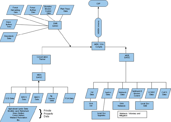
FIGURE C-1 Current tracking and reporting scheme from Maryland’s WIP.
Source: MDE et al., 2010
• Stormwater - MDE requires regular maintenance and inspection of all BMPs, at least once every 3 years. MDE has over 33,000 facilities in its urban BMP database. More than 22,000 of these have been verified by MDE’s Science Services Administration.
• Agriculture o MDA aims to conduct field checks for 10% of all BMPs implemented within active maintenance life span to ensure they continue to function according to design standards. However, recent staffing levels have allowed rates of only 7-8 percent annually.
ο The Maryland Agricultural Water Quality Cost Share (MACS) program aims to spot check 10 percent of all funded practices each year (this check is in addition to the inspection that takes place during BMP construction).
ο For the MDA Cover Crop Program, Soil Conservation Districts inspect 100 percent of participants who fall certify (at least 20 percent of each participants acreage is inspected). An additional random check of 10 percent of the contracts is conducted in the spring.
ο Manure transport program- tracking and verification for manure transport is based on the following procedures: a) selection of up to 10% of any of the active and completed agreements; b) inspections conducted as a result from a complaint from an adjacent property owner of others; and c) inspections in conjunction with a nutrient management implementation review.
ο Nutrient Management Plans: MDA strives to complete approx. 400 randomly selected field inspections per year, which include a review of the plan and all farm records as well as a visual inspection of other BMPs on the farm. Plans are also reviewed at MDA headquarters. Farmers must have their nutrient management plans reviewed and approved to participate in state incentive programs.
ο CAFOs: MDA plans to conduct up to 100 site inspections at CAFO/MAFO operations to ensure they are meeting their permit requirements.
4) What are the procedures for tracking and verifying that voluntary practices are properly designed, installed and maintained over the lifespan of the practice according to state/USDA practice standards?
Maryland will also be initiating a pilot program where soil conservation districts would conduct on farm walking inventories of all of the current practices farmers have installed without incentives. An on-farm nutrient calculation tool will be utilized to assess the farm and to analyze additional management options.
5) How does the tracking and reporting system incorporate quality controls and protect against double-counting?
Point source:
• The point-source data undergo an extensive analysis, editing, and verification process prior to input in the MDE database., including: (1) checking for missing & redundant values, (2) checking data ranges against permit values, (3) comparing monthly averages to previous year’s, and (4) graphically analyzing data to identify errors or gaps.
Non-point source:
QA/QC provided by MDE, MDA and Science Services Administration according to Figure B-1. Details of quality assurance practices for agricultural BMPs, including numerous procedures to protect against double counting, are outlined in Maryland’s QAPP. MDE working with local governments to develop tracking and reporting protocols to ensure no double-counting for stormwater BMPs.
6) Does the non-point source practice and program implementation data include a practice/credit life? What is the process for removing practices from the tracking systems once they have expired, are out of date, are not functioning as designed, or no longer exist?
Once a BMP exceeded maintenance life (~10-15 years), that BMP is removed from the list.
7) What practices may be underreported?
• Stream restoration information because there is no mechanism for reporting and no requirement to do so.
• Septic upgrades done by local government where state funding is not involved.
Innovative practices not currently approved by the CBPO.
Strengths and Weaknesses
• Maryland’s Bay Stat is used to record data on point source control upgrades at a monthly rate.
• Conservation Tracker can be used to account for voluntary practices.
• Developing a GIS-based tracking system for all BMPs.
• A large amount of time is spent geo-locating the practice when the location is not provided.
• Limited staff resources are an impediment in tracking/accounting efforts.
NEW YORK
The following information was compiled from the WIP (NY DEC, 2010) and responses to a committee questionnaire (P. Freehafer, NYSDEC, personal communication, 2010).
1) Who is responsible for collecting, reporting, and verifying nutrient and sediment controls?
Point source:
• The New York State Department of Environmental Conservation (NYSDEC) collects monthly wastewater discharges from DMRs submitted under NPDES permits.
Non-point source:
• The Upper Susquehanna Coalition (USC) accounts for the nonpoint source implementation (primarily agriculture and wetland related). Only practices accounted for on-the-ground are reported to the Bay Program. NYSDEC collects the data for the USC model from the Notices of Intent it receives from applicants for stormwater permits.
2) Are the practices geo-referenced?
USC geo-locates and field checks agricultural practices.
3) What are procedures for tracking and verifying that regulatory and contracted practices are properly designed, installed and maintained over the lifespan of the practice according to state/USDA practice standards?
Non-point source:
• Septic - None reported.
• Stormwater - None reported.
• Agriculture - USC field checks all practices.
4) What are the procedures for tracking and verifying that voluntary practices are properly designed, installed and maintained over the lifespan of the practice according to state/USDA practice standards?
None reported.
5) How does the tracking and reporting system incorporate quality controls and protect against double-counting?
• Strategies to prevent double-counting not reported.
• Quality control procedures outline in the QAPP (USC, 2002). USC does a simple analysis in Excel to search for outliers in the database and compared with the appropriate hard copy. USC will select 50 data
sheets and compare the hard copy to the data entered and uses this test as an estimate of data entry reliability.
6) Does the non-point source practice and program implementation data include a practice/credit life? What is the process for removing practices from the tracking systems once they have expired, are out of date, are not functioning as designed, or no longer exist?
Information not provided.
7) What practices may be underreported?
Urban and septic practices are generally not reported because of a shortage of staff resources and their relative low contribution to nutrient loads in the NY portion of the watershed.
Strengths and Weaknesses
• USC provides a reliable comprehensive accounting of all agriculture land uses and practices implemented.
• Urban and septic practices are generally not reported because of a shortage of staff resources.
PENNSYLVANIA
The following information was compiled from the WIP (PA DEP, 2010), responses to a committee questionnaire, and personal communication for factual corrections (P. Buckley, PA DEP, personal communication, 2010, 2011).
1) Who is responsible for collecting, reporting, and verifying nutrient and sediment controls?
Point source:
• The Pennsylvania Department of Environmental Protection (PA DEP) tracks monthly wastewater discharges from DMRs submitted under NPDES permits.
• CAFOs are reported to the EPA similar to the reporting mechanism for agricultural BMPs.
Non-point source:
• Septic - No one. Pennsylvania is not including a septic nutrient reduction program due to limited technology options, limited contribution to the Bay, and limited benefit relative to cost. In Pennsylvania, on-lot sewage treatment systems are regulated by Sewage Enforcement Officers at the local government level (sub-county). There are approximately 1200 municipalities in Pennsylvania’s Chesapeake watershed. Pennsylvania
does not maintain a statewide database of those systems and does not have the staff or other resources necessary to create such a system.
• Stormwater - PA DEP tracks stormwater BMPs from the NPDES MS4 annual reports. At this time there is no database or process for compiling and reporting of the stormwater BMP data. Construction site BMPs are reported in permit applications submitted to DEP, but this information is not compiled due to staffing limitations. Instead, for CBP reporting, an estimate was made of the acres of urban land with stormwater BMPs using Act 167 county stormwater management plans, construction permit acreage data, and conservative best professional judgment.
• Land use - information not provided.
• Agriculture - PA DEP collects data from various sources shown in Table C-1. Conservation districts are now tracking manure transport, although these files only cover approximately 50 percent of the manure transport, and additional data collection efforts are being developed through the Department of Agriculture.
• Forests - PA DEP tracks new riparian forest buffers, whereas urban tree canopy expansion and forest land conservation are tracked by DCNR Bureau of Forestry.
2) Are the practices geo-referenced?
Non-point source:
• Septic - No
• Stormwater - No
• Agricultural BMPs - Only to county or watershed code scale
3) What are procedures for tracking and verifying that regulatory and contracted practices are properly designed, installed and maintained over the lifespan of the practice according to state/USDA practice standards?
Non-point source:
• Septic - none
• Stormwater - Construction-related stormwater BMPs are permitted and verified. These practices are reported to DEP; but at this time there is no centralized tracking database specific to these practices. It is anticipated that these practices eventually will be entered into the non-point source data repository.
• Agriculture - Verification and quality assurance of the BMPs implemented are considered to be the responsibility of the federal and state agencies and the NGOs providing the information. It is beyond the capacity or responsibility of the PA Water Planning Office to complete such tasks. No information is provided in the WIP about state agency-level verification.
TABLE C-l Sources of Agricultural BMP data in Pennsylvania. |
| Data Source | How Information is Received | Geographical Reporting Level |
| DEP Stream Fencing Program | Electronic spreadsheet from program database | County SWPC |
| DEP Chesapeake Bay Implementation Giant | Electronic spreadsheet from program database | County SWPC |
| DEP Section 319 Non-point Source Program | Paper spreadsheet based on review of GRTS database | County SWPC |
| DEP Abandoned Mined Land Reclamation Program | Electronic spreadsheet from program database | County |
| DCNR Forest Stewardship Program | Electronic spreadsheet from program database | County |
| Pa. Act 6 Nutrient Management Program | Electronic spreadsheet from program database | County SWPC |
| Pa Stream Relief Program | Electronic spreadsheet from program database | County |
| Pa Growing Greener Giant Program | Electronic spreadsheet from program database | SWPC |
| Pa. Act 102 Erosion and Sedimentation Program | Electronic spreadsheet from program database | County |
| PDA Agci-Lmk Program | Spreadsheet received by e-mail from PDA Office | County |
| FSA Conservation Reserve Program | Spreadsheets downloaded directly from FSA Pa website | County |
| FSA Conservation Reserve Enhanced Program | Spreadsheets downloaded directly from FSA Pa |
County |
| NRCS EnviiOimiental Quality Incentive Program | Spreadsheets downloaded directly from NRCS Pa website | County |
| USDA Rural Development Program (septic system hookups to treatment facilities | Listing received by e-mail from USDA Pa Rural |
County and Township |
| PSU Center for Dirt and Gravel Road Studies | Electronic Spreadsheet | County |
| USDA National Agricultural Statistics Service | Spreadslieet download from website | County |
| American Farmland Trust | Spreadsheet received by e-mail | County |
| PDA - Reap Program | Electronic Spreadsheet | County |
| DEP Nutrient trading Program | Electronic Spreadsheet | County P4.3 Model Segment |
SOURCE: PA DEP (2010).
4) What are the procedures for tracking and verifying that voluntary practices are properly designed, installed and maintained over the lifespan of the practice according to state/USDA practice standards?
Plans for tracking and verifying voluntary practices are under development.
5) How does the tracking and reporting system incorporate quality controls and protect against double-counting?
Not described in WIP or QAPP. Like all states, Pennsylvania tracks practices by funding sources, which it states should help reduce double-counting.
6) Does the non-point source practice and program implementation data include a practice/credit life? What is the process for removing practices from the tracking systems once they have expired, are out of date, are not functioning as designed, or no longer exist?
Not described in WIP or QAPP.
7) What practices may be underreported?
Cover Crops, no-till cultivation, manure storage, stream fencing, rotational grazing, stream bank protection, street cleaning, municipal sewage connections, managed precision agriculture, precision feeding, forest harvesting practices, established wetlands, and forest harvesting practices.
Strengths and Weaknesses
• The current tracking and reporting systems have insufficient funds and resources to reliably track BMPs implemented by all sectors. There are state programs that do not have centralized databases.
• DEP has developed a non-point source BMP repository to store all the non-point source BMP information that will be collected. DEP is in the process of populating the repository with information from state programs. The repository has been structured so that individuals or environmental groups will be able to enter BMP information which they privately implement apart from state or federal cost-shared programs.
VIRGINIA
The following information was compiled from the WIP (VA SNR, 2010), responses to a committee questionnaire, and personal communication for factual corrections (A. Pollock, VADEQ, personal communication, 2010, 2011).
1) Who is responsible for collecting, reporting, and verifying nutrient and sediment controls?
Point source:
• VA Department of Environmental Quality (DEQ) collects total annual nitrogen and phosphorus discharges in wastewater under NPDES permit requirements. Discharge monitor reports are also required in the Nutrient Watershed General Permit, and DEQ publishes an annual discharge report for all facilities covered by the general permit.
• Modeled flows and event mean concentration data are used to calculate loads from combined sewer systems reported by the state.
Non-point source:
• Septic - Virginia Department of Health (VDH) uses Virginia Environmental Information System (VENIS), a statewide database that captures all new applications for permits. VDH also has an internal goal of capturing 10 percent of the legacy systems per year. The Department of Conservation and Recreation (DCR) tracks and reports septic pump-out practices.
• Stormwater - The Department of Conservation and Recreation (DCR) receives reports from MS4 localities on installed BMPs as a condition of their permits. A Stormwater Management Enterprise web site is in development to digitally track and report urban/suburban BMPs installed by localities.
• Landuse - not covered separately in Virginia’s WIP.
• Agriculture - Agricultural BMPs are reported through the Agriculture Cost Share Program Tracking Database by DCR and DEQ tracks poultry litter transport between counties in Virginia. DEQ inspects permitted AFO related BMPs.
• Forest - Department of Forestry tracks BMPs.
2) Are the practices geo-referenced?
• Agricultural cost shared practices have point locations. Virginia is developing system for point locations for nutrient management plans and stormwater BMPs. (W. Keeling, VA DCR, personal communication, 2010)
• VDH is working to capture point locations for onsite (septic) BMPs.
3) What are procedures for tracking and verifying that regulatory and contracted practices are properly designed, installed and maintained over the lifespan of the practice according to state/USDA practice standards?
Point source:
• CAFOs permitted under the VPDES regulation will be inspected at least once every 5 years based on a risk-based inspection strategy by DEQ staff in order to verify implementation of the required BMPs.
Non-point source:
• Septic - Septic pumpouts are reported to VA DCR for the localities subject to the requirements of the VA Chesapeake Bay Preservation Act. VDH is working to capture pump out data in those counties located within the Chesapeake Bay watershed that are not subject to the requirements of the VA Chesapeake Bay Preservation Act. In addition, any BMP that is also defined as an “alternative onsite sewage system” (AOSS) requires at least an annual inspection by a licensed AOSS operator with a report to VDH.
• Stormwater - DCR conducts inspections of land disturbing activities to confirm the details included in the annual reports and conducts approximately 1,500 to 2,000 inspections on permitted activities.
• Agriculture - Once installed, Soil and Water Conservation Districts must certify that the practice fulfills all BMP requirements. BMPs that receive state financial incentives are subject to field spot checks for the practice lifespan to determine if a BMP is damaged and not performing its intended purpose. DCR monitors the implementation of installed BMPs by randomly selecting 5 percent of the installed practices within a program year, and 5 percent of the prior multi-year BMPs for field inspections, except where statewide the practice exceeds 400 total installations, in which case only 20 installations of that practice need to be checked. AFOs permitted under the VPA regulation are currently inspected annually by DEQ staff and after 7/1/2011 at least once every 5 years based on a risk-based inspection strategy in order to verify implementation of the required BMPs.
4) What are the procedures for tracking and verifying that voluntary practices are properly designed, installed and maintained over the lifespan of the practice according to state/USDA practice standards?
“Virginia’s 47 Soil and Water Conservation Districts will be the primary mechanism for collection, verification and data entry for agricultural BMPs. DOF will collect, verify and report voluntary forest BMP data. DCR’s web-based Agricultural BMP Tracking Program is currently used by all 47 SWCDs and will be modified for voluntary BMP entry, storage and reporting. The strategy calls for a multi-phased approach with Phase I pilot effort beginning in 2011 and the Phase II expansion statewide effort beginning in 2012 and continuing with Phase III in 2013” (VA SNR, 2010). No procedures have been developed as of 2010.
5) How does the tracking and reporting system incorporate quality controls and protect against double-counting?
• With the NEIEN reporting protocol NRCS will be reporting data directly to EPA. VA received NRCS raw data and conducted analysis of the NRCS and VA Agricultural Cost Share program raw data to determine possible duplicate records. A list of possible duplicate ID numbers (NRCS Object ID) were submitted to NRCS and USGS so that these records could be removed from the NRCS BMP data. USGS is responsible for aggregation and NEIEN reporting via agreement for USDA.
• QA/QC procedures detailed in the Quality Assurance Project Plan (VA DCR, 2006). The quality assurance of the data provided by NRCS, VDOF, and DMME is the responsibility of the respective agency. DCR does perform periodic spot checks on data reports. VA DCR is updating the existing QAPP to document changes to the tracking and reporting systems. This will include descriptions of the NEIEN processes VA DCR has implemented.
6) Does the non-point source practice and program implementation data include a practice/credit life? What is the process for removing practices from the tracking systems once they have expired, are out of date, are not functioning as designed, or no longer exist?
• Random inspections are performed for the longer term, multi-year agricultural BMPs, to confirm that the practices are continuing to perform as designed and implemented. No mention of a practice or credit life is provided.
• BMPs for onsite sewage (septic) systems, with the exception of pump outs, are considered permanent. See #3 above for verification procedures.
7) What practices may be underreported?
• Hook ups of on-site septic systems to centralized systems are not tracked.
• Non-cost-shared agricultural practices.
• Urban stormwater BMPs on land developed over last 20 years.
• Practices not approved by CBP.
Strengths and Weaknesses
• There has been inconsistent, or in most cases, a lack of reporting of installed stormwater management practices, and most are reported in paper format. A new Stormwater Management Enterprise Web site is being proposed to address this problem.
• Data for onsite sewage systems, including installed BMPs, is not currently geo-coded. VDH’s VENIS data base has the capability to store this information and VDH will be working in the future with field offices to begin collecting point locations. Capturing sewer connections (septic BMP) will require cooperation of local government units that are not part of onsite sewage permitting processes at this time.
WEST VIRGINIA
The following information was compiled from the WIP (WV WIPDT et al., 2010), responses to a committee questionnaire, and personal communication for factual corrections (T. Koon, WV DEP, personal communication, 2010, 2011).
1) Who is responsible for collecting, reporting, and verifying nutrient and sediment controls?
Point source:
• West Virginia Department of Environmental Protection (WVDEP) tracks monthly discharges of significant facilities (>0.4 MGD) and all new facilities from NPDES permits into the Permit Compliance System (PCS) reports.
Non-point source:
• Septic - WVDEP staff collects this information by making calls to relevant agencies, utilities, and businesses.
• Stormwater - WVDEP tracks and reports industrial stormwater management practices and maximum disturbed concurrently registered area by county on an annual basis. DEP is also developing a standardized form for MS4s for tracking implementation of runoff reduction practices and retrofits. The WV DEP Construction stormwater program will collect post-construction stormwater BMPs for MS4 and non-MS4 area development.
• Land use - WV DEP construction stormwater program will collect land-use information through the construction stormwater permit for MS4 and non-MS4 areas.
• Agriculture - Federal agencies (NRCS, FSA) have tracking protocols and summarized data can be obtained from their online database. WVDA tracks nutrient management plans, WVCA tracks all agricultural state cost-shared practices as well as those from watershed associations and NGOs. WV Dept. of Agriculture and the WV Conservation Agency will work to develop tracking and reporting protocols to account for non-cost-shared practices.
2) Are the practices geo-referenced?
Under the Construction Stormwater General Permit, latitude and longitude is provided on the application. When state agency partners are involved in riparian buffer, wetland, stormwater retrofit, or stream restoration projects, latitude and longitude are usually known and on file, but have not been transmitted to CBPO as part of the annual data submission. For most other practices, especially the agriculture BMPs reported by NRCS, the number of units of a given BMP are added and reported as one number per county. All practices have been reported by county.
3) What are procedures for tracking and verifying that regulatory and contracted practices are properly designed, installed and maintained over the lifespan of the practice according to state/USDA practice standards?
Non-point source:
• Septic - information not provided
• Stormwater - WV does not have a system in place to verify whether post-construction stormwater BMPs were ever actually installed, or whether the number of acres ultimately draining to them was correct, or whether they have been adequately maintained over the years. The WVDEP plans to develop protocols for annual inspections to certify that new and existing regulated and unregulated urban stormwater BMPs are in place and functioning as intended.
• Agriculture - The WVDA plans to use current nutrient management planners to assist with tracking and reporting activities while they are in the field. CAFO verification protocols have not been fully implemented. NRCS employs a system of inspecting completed practices and spot-checking through the life of the cost-sharing contract.
4) What are the procedures for tracking and verifying that voluntary practices are properly designed, installed and maintained over the lifespan of the practice according to state/USDA practice standards?
Procedures for tracking both agriculture and post construction stormwater voluntary practices are in development.
5) How does the tracking and reporting system incorporate quality controls and protect against double-counting?
• The MS4 annual report and the DEP Construction Stormwater tracking systems will be compared to ensure all land use, runoff reduction and retrofit BMPs are reported and to prevent double counting within the MS4s.
• For nonpoint source agriculture BMPs reported by multiple agencies, DEP staff has questioned those agencies when needed to make sure they
are not reporting the same practices. When in doubt, the conservative choice has been made.
6) Does the non-point source practice and program implementation data include a practice/credit life? What is the process for removing practices from the tracking systems once they have expired, are out of date, are not functioning as designed, or no longer exist?
No information provided.
7) What practices may be underreported?
Non-cost shared BMPs.
Strengths and Weaknesses
• WV relies upon staff-intensive data collection methods for some data collection (e.g., calling agencies to get data on septic systems installed or numbers of systems pumped). They lack the web-interfaces to facilitate easier data reporting.
• The NRCS database was not designed with CBP reporting needs in mind and could be improved to ease BMP reporting.


