
2
Scientific Accomplishments: Solid Earth Cycles
Data from scientific ocean drilling have offered important insights through which we have begun to better understand solid Earth cycles, including the interaction and evolution of Earth’s crust, mantle, and core. Changes in Earth’s magnetic field, the processes of continental rifting, the subduction of oceanic lithosphere, and voluminous outpourings of magma onto the crust, for example, are significant manifestations of solid Earth cycles and are recorded in rocks on the ocean floor. The following sections review the scientific accomplishments and new fields of inquiry that scientific ocean drilling results have fostered in our knowledge of the solid Earth. Some of the remaining challenges about the solid Earth to which scientific ocean drilling can contribute are also discussed.
Earth’s magnetic dipole field, generated in the liquid outer core, undergoes occasional reversals that are recorded in rocks containing iron-bearing magnetic (ferromagnetic, sensu lato) minerals. Because of the globally contemporaneous nature of Earth’s magnetic field reversals, rocks preserving these magnetic signatures can be precisely dated and can serve as markers for the frequency and duration of magnetic reversals through geologic time. These kinds of magnetic minerals are typically abundant in basaltic rocks (such as ocean crust) and in some fine-grained sedimentary rocks overlying the ocean crust. Researchers involved in scientific ocean drilling have been able to take advantage of the magnetic properties of these rocks for more than four decades, spurring numerous fundamental discoveries, for example, about the age of the ocean crust, the way in which ocean crust is generated and destroyed, the timing of climatic oscillations, and the development of accurate geologic time scales.
Scientific Accomplishments and Significance
The most widely known scientific accomplishment for which scientific ocean drilling was essential is the verification of the seafloor spreading hypothesis (Box 2.1), a lynch-pin for establishing the paradigm of plate tectonics in the early 1970s. Scientific ocean drilling focused on obtaining ages of the seafloor magnetic reversal stratigraphy and corresponding biostratigraphic ages of sediments at successive distances from the Mid-Atlantic Ridge axis; these data confirmed the increasing age of ocean crust away from seafloor spreading centers. The landmark verification of the seafloor spreading hypothesis occurred as a result of the earliest Deep Sea Drilling Project (DSDP) cruises and particularly with data from DSDP Leg 3, which drilled to the top of the oceanic basement in the South Atlantic (e.g., Maxwell et al., 1970). Biostratigraphic, magnetostratigraphic, and isotope geochronologic analyses of seafloor samples from subsequent DSDP cruises (e.g., DSDP Legs 5, 6, 12) combined with similar data from continental sequences led to development of precise geologic time scales, specifically the Geomagnetic Polarity Time Scale (GPTS), which included astronomical, geomagnetic, and biostratigraphic calibrations (e.g., Berggren et al., 1985; Cande and Kent, 1995; Gradstein et al., 2004; Box 2.2). Another significant achieving of the scientific ocean drilling program was modeling the magnetic contributions of submarine source layers (basalt and gabbro), which matched the observed marine magnetic anomalies.
Beyond these first-order contributions, drill cores led to the discovery of variations in spreading rates between ocean basins and the age of the oldest ocean crust (e.g., DSDP Legs 9 and 69 and Ocean Drilling Program [ODP] Leg 138; Hayes et al., 1972; Wilson et al., 2003). A new way to confirm lateral seafloor spreading rates and the veracity of the GPTS came from analysis of vertical magnetic reversal stratigraphy
Box 2.1
Con rmation of Seafloor Spreading
One of the earliest and most significant accomplishments of scientific ocean drilling was to provide data that confirmed seafloor spreading. Data and samples retrieved by the drillship Glomar Challenger in the early 1970s were used to confirm that new ocean crust was being generated at mid-ocean ridges, supporting the complete theory of plate tectonics, the paradigm for solid Earth science. Data from survey ships that provided geophysical evidence for the existence of symmetric, alternating patterns of magnetic polarity (“magnetic anomalies”) on either side of the world’s mid-ocean ridges led to suggestions by various scientists in the early 1960s that new ocean crust was being created there. However, these interpretations could not be conclusively substantiated in the absence of data directly obtained from the seafloor. In 1970, Glomar Challenger drilled a series of boreholes across the Mid-Atlantic Ridge in the South Atlantic and retrieved basal sediments that had been deposited on ocean crust. The biostratigraphic ages of those samples increased nearly linearly with distance from the ridge crest, in close agreement with the ages predicted by analysis of the magnetic anomalies on the seafloor. Confirmation of the theory of seafloor spreading had direct consequences for the development of new fields of scientific inquiry and cross-disciplinary geoscientific research.
SOURCES: Dietz, 1961; Hess, 1962; Vine and Matthews, 1963; Heirtzler et al., 1968; Maxwell etal., 1970.
recovered from ocean sediments at ODP Sites 677 and 846, where benthic and planktonic foraminiferal dates were correlated with Earth’s orbital variations (e.g., Shackleton et al., 1990; also see Chapter 4). These results, in turn, have had implications for understanding of the composition and behavior of oceanic lithosphere, processes occurring at subduction zones, and the formation of large igneous provinces (LIPs) (see later sections of this chapter).
The development of hydraulic piston coring (HPC) and advanced piston coring (APC; see Box 2.2) allowed sampling of continuous undisturbed sediment cores from below the sediment-water interface to the crystalline bedrock (Prell et al., 1980; Ruddiman et al., 1986; also see Box 4.3). This unique achievement allowed the creation of a high-fidelity Cenozoic paleoceanographic/paleoclimatic time series by cross-validating magnetic dipole reversal stratigraphy from ocean core samples with higher resolution biostratigraphy and astronomically forced climate variations recorded in finely laminated ocean sediments (e.g., Hilgen, 1991). The basis for such an approach was first proposed by Shackleton and Opdyke (1973) when they dated high-resolution δ18O stratigraphy with fixed-point magnetic reversal ages to yield multi-millennial-scale paleoclimate (i.e., global ice volume) records. When Hilgen (1991) extended his earlier cyclostrati-graphic work to the Miocene-Pliocene boundary, it became possible to obtain three-way cross-validation of dated paleoclimate (biostratigraphy and lithostratigraphy based) records whose ultimate fixed-point dating scheme rested on the GPTS, synthesized from sediments of the world’s oceans. A global approach to developing a precise astronomical time scale used many DSDP and ODP cores and enabled oxygen isotope excursions to be precisely dated (e.g., Lisiecki and Raymo, 2005; Box 2.2; also see Chapter 4).
Another method to correlate oxygen isotope changes with age and geomagnetic reversals or excursions uses the relative paleointensity of sediment cores (e.g., Channell et al., 2009; Figure 2.1). This method has provided independent age calibrations to which climate changes can be compared and is also valuable for understanding the behavior of Earth’s magnetic field through time. Measurements of continuous relative geomagnetic paleointensity from long sediment cores have confirmed occurrence of intensity minima during dipole reversals and helped discover short-term dipole excursions.
Another accomplishment in the area of global plate motions and reconstructions came when cores collected on DSDP Leg 55 led to the initial recognition that the Hawaiian hotspot had not always been fixed at the latitude of Hawaii (Kono, 1980). In 1992, ODP Leg 145 cored a thickness of ocean floor basalt opposite Detroit Seamount, one of the oldest seamounts in the Hawaiian-Emperor chain, and determined that its paleomagnetic latitude of formation was well north of Hawaii (Tarduno et al., 2003). ODP Leg 197 provided compelling paleomagnetic evidence that from about 76 to 45 myr the Hawaiian hotspot was rapidly migrating southward to reach its present position, a finding that held implications for reconstructing past Pacific plate motions and also for the concepts of plume stability and mantle dynamics and circulation.
Fields of Inquiry Enabled
Research derived from scientific ocean drilling has fundamentally influenced and advanced the fields of plate tectonics, paleomagnetism and geomagnetism, and geologic time scales. The combination of high-resolution magnetostratigraphy and relative paleointensity; oxygen isotope records as a proxy for changes in climate; and bio-, cyclo-, and lithostratigraphy have helped further the study of paleoclimate and paleoceanography (discussed in further detail in Chapter 4), which attests to the importance of cross-disciplinary approaches in advancing research of the ocean floor and Earth processes.
Box 2.2
The Development and Evolution of Geological Time Scales
Scientific ocean drilling has contributed significantly to the development of an accurate geological time scale for the past 150 million years (myr). The verification of seafloor spreading by dating basal age microfossils (Maxwell et al., 1970) tied together paleomagnetic reversal stratigraphy with seafloor magnetic anomalies and provided the first accurate time scales linking the age of ocean crust to the nannofossil and foraminiferal biostratigraphy of European uplifted marine sections (Berggren, 1969; Berggren et al., 1985). Building on this early success, the development of hydraulic and advanced piston corers (HPC and APC) in the late 1970s produced undisturbed marine sections that recorded paleomagnetic reversals, which allowed researchers to use changes in microfossil oxygen isotope chemistry controlled by long-term cycles in Earth’s orbit (Milankovitch climate cycles) to date the paleomagnetic reversal stratigraphy. Previously these sections could only be recovered using traditional piston coring (Shackleton and Opdyke, 1973, 1976) in relatively recent marine sediments with slow sedimentation rates. The APC provided the first long, high-resolution records of oxygen isotope variations and paleomagnetic reversals, leading to the confirmation of the orbital theory of ice ages (Hays et al., 1976) and the observation of the pervasive fingerprint of orbital forcing on the marine record of climate change (further discussed in Chapter 4). Shackleton et al. (1990) extended the orbitally calibrated oxygen isotope chronology into the Pliocene in ODP Site 677 and noted that the dates of the magnetic reversals previously established by the radiometric dating of seafloor basalts were 5 to 7 percent younger than their predicted ages based on astronomical calibration, suggesting that the radiometric dates constraining the reversals were in error. Hilgen (1991) confirmed the Shackleton et al. (1990) observations through orbital tuning of uplifted Mediterranean marine sections and, in conjunction with the high-resolution oxygen isotope record from ODP Site 846 (Shackleton, 1995), further extended the time scale into the Miocene. The combined results of Shackleton et al. (1990, 1995) and Hilgen (1991) produced the first Astronomical Polarity Time Scale (Kent, 1999). Subsequent research showed that the K-Ar ages of the original time scales were indeed too young (Tauxe et al., 1992), and new 40Ar/39Ar radiometric results showed the same ages as the orbitally tuned dates. Deeper and older recoveries with the APC and extended core barrel systems extended the orbital chronology continuously back to 5 myr: Lisiecki and Raymo (2005) combined 36 DSDP and ODP sites to produce an astronomical time scale for the marine oxygen isotope record of the past 5 myr. This work was subsequently extended back into the Cenozoic (Billups et al., 2004; Palike et al., 2006; Westerhold et al., 2008) with an accuracy of several tens of thousands of years.
Goals Not Yet Accomplished
As one of the earliest scientific ocean drilling fields, the field of geomagnetism has seen many of its goals accomplished. However, fundamental questions still remain in the mechanisms behind magnetic field reversals and extending temporal resolution of magnetic polarity stratigraphy. Continued work on paleomagnetism of deeper ocean crust (gabbros and ultramafic rocks) may address the sources of marine magnetic anomalies, providing observational benchmarks for geodynamo models of motions in Earth’s liquid iron core. Unanswered questions related to high-resolution past climate change may also draw upon the combination of paleomagnetic, biostratigraphic, isotopic, and astronomical work on ocean cores for resolution.
STRUCTURE, COMPOSITION, AND
FORMATION OF OCEANIC LITHOSPHERE
Earth’s lithosphere consists of the crust and the non-convecting portion of the upper mantle, formed by repeated magmatic activity at mid-ocean ridges. This magmatism is the dominant process helping to transfer mass and heat from Earth’s interior. Approximately 62-75 percent of the global magma production rate of ~30 km3/yr comes from mid-ocean ridge environments, with ~85 percent of this volume as plutonic rocks (predominantly gabbros) and the rest erupted on the ocean floor in the form of basaltic lava (Crisp, 1984). The oceanic lithosphere forms the outermost layer of the solid Earth and consists of this mafic crust (gabbros and basalts) and rigid ultramafic upper mantle (typically of peridotite composition); the crustal layer is about 5-10 km thick, and the upper mantle section can extend for another ~90 km below the crust.
Preliminary observations from results of scientific ocean drilling suggest that oceanic lithosphere compositions differ depending upon the spreading rate of the nearby ridge system (Box 2.3). The only way to obtain direct measurements of the properties of oceanic lithosphere to understand its composition, genesis, and structure, and the causes and consequences of different ridge spreading rates, is through the type of sampling enabled by scientific ocean drilling.
Scientific Accomplishments and Significance
One motivation for early drilling into ocean crust was to assess whether oceanic lithosphere has a layered lithological structure from top to bottom of pillow basalts, sheeted dikes, gabbros, and ultramafic rocks (Box 2.3) in a manner similar
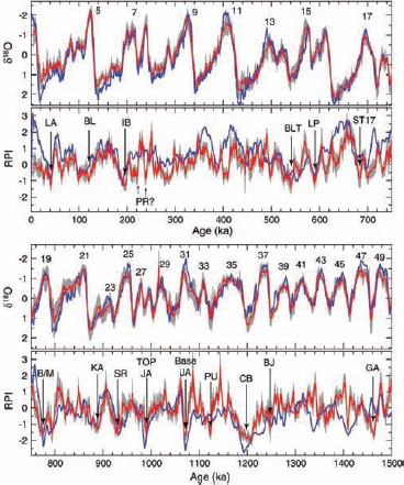
FIGURE 2.1 Oxygen isotope (δ18O) and relative paleointensity (RPI). Half-width of the error envelope in both cases is 2σ (2 × standard error). The oxygen isotope stack (red) is compared with the LR04 benthic isotope stack (blue) (Lisiecki and Raymo, 2005). Paleointensity minima in the stack correspond to established ages of magnetic excursions and chron/subschron boundaries: LA-Laschamp, BL-Blake, IB-Iceland Basin, PR-Pringle Falls, BLT-Big Lost, LP-La Palma, ST17-Stage 17, B/M-Brunhes-Matuyama boundary, KA-Kamikatsutra, SR-Santa Rosa, JA-Jaramillo Subchron, PU-Punaruu, CB-Cobb Mountain Subchron, BJ-Bjorn, GA-Gardar. SOURCE: Channell et al., 2009.
to the structure of ophiolites on land (called the “Penrose model” after a 1972 Penrose Field Conference consensus definition of ophiolite structure; Anonymous, 1972). Penetration into ocean crust was inaugurated by DSDP Leg 37 in 1974 at 37° N along the Mid-Atlantic Ridge. Although the total number of holes drilled into ocean crust between 1974 and the end of ODP in 2004 is about 50, these early efforts were hampered by technical difficulties in both penetrating the very dense crystalline rock and recovering samples. Only 17 of those 50 holes penetrated depths greater than 200 m into the crust, and only 7 holes reached depths greater than 500 m within crystalline rocks (Dick et al., 2006; Figure 1.3). One of these holes, 1256D, is notable for penetrating 1,507 m into superfast-spreading lithosphere produced at the East Pacific Rise. Not only did drilling reveal a classic, Penrose-type crust of pillow basalt, sheeted dikes, and gabbros, but it was also the first time a full, intact section was drilled, providing insight into oceanic crust formation (Teagle et al., 2006; Wilson et al., 2006).
These technological impediments to deeper drilling encouraged innovations: (1) improvements in drilling capabilities enabled by both ODP and IODP and (2) development of the concept of “tectonic windows,” i.e., regions where strata that are usually deeply buried have been brought closer to or exposed on the seafloor through tectonic processes such as low-angle detachment faults (e.g., Ildefonse et al., 2007; Escartin et al., 2008). The innovation to sample these tectonic windows through scientific ocean drilling has made it possible to reach gabbroic and, in some cases, mantle sections of oceanic lithosphere (e.g., Cannat et al., 1997, 2006; Kelemen et al., 2004, 2007). ODP Hole 735B on Atlantis Bank in the Indian Ocean, for example, penetrated 1,508 m into gabbro (Dick et al., 1999); two Mid-Atlantic Ridge drill holes, 920D at 23° N and 1275 at 16° N, each penetrated ~200 m into mantle peridotite (Cannat et al., 1995; Kelemen et al., 2004); and ODP Hole 895D penetrated 94 m into peridotite exposed through rifted Pacific crust (Gillis et al., 1993). The presence of ultramafic rocks at or near the surface of the ocean floor at a number of slow and ultraslow spreading centers (e.g., Kelemen et al., 2004; Blackman et al., 2006) has resurrected the idea that the Hess model for oceanic lithosphere (i.e., serpentinized peridotite is overlain in igneous or tectonic contact by a thin layer of volcanic material; Hess, 1962) could apply to large sections of the oceanic lithosphere (Dick et al., 2003; Michael et al., 2003). Although most of the erupted lavas are focused on or are close to the ridge axial summit, mapping efforts combined with isotopic analyses of drilled samples and seismic surveys have shown that lateral magma transport may also occur through dikes in the shallow crust that erupt off-axis to form seamounts (Zou et al., 2002; Durant and Toomey, 2009).
Drilling innovations, such as the use of a re-entry cone guide to begin drilling hard rock formations and a drilling fluid-powered hammer to begin holes, have allowed re-entry to hard rock formations on the seafloor. Other innovations include testing of a mining-type continuous coring operation from a compensated platform, and mud motor-driven core barrels (Miller and Huey, 1992; Brewer et al., 2005). These improvements led to increases in the depths of holes drilled during IODP legs and in the amount of recovered core. For example, IODP Hole 1309D on the Atlantis Massif along the Mid-Atlantic Ridge penetrated to a depth of 1,415 m, and Hole 1256D in the equatorial east Pacific penetrated to 1,507 m (e.g., Blackman et al., 2006; Teagle et al., 2006; Wilson et al., 2006; Drouin et al., 2009).
Drilling on ODP Legs 147 and 209 confirmed the presence of abundant impregnated periodotites formed by partial crystallization of migrating mantle melt beneath the base of the crust and ODP Leg 209 and IODP Expeditions 304-305 substantiated that the lower crust was composed of many small sills rather than one large magma chamber (Mével
Box 2.3
Structure of Oceanic Lithosphere
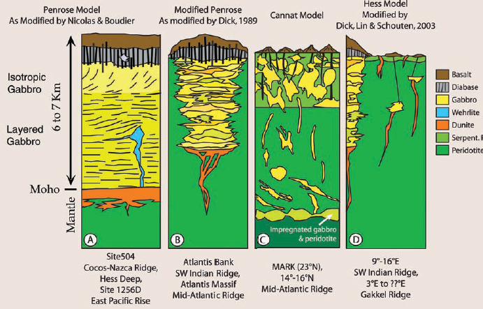
The structure and thickness of oceanic lithosphere depend a great deal on spreading rates. An idealized ("Penrose model") structure of oceanic lithosphere includes pelagic sediments (layer 1), pillow basalts (layer 2A), sheeted dikes (layer 2B), isotropic gabbros (layer 3A), layered gabbros (layer 3B), and ultramafics (layer 4). However, the complete sequence is ubiquitous only in lithosphere produced at fast and intermediate spreading ridges, such as the Cocos-Nazca Ridge (Figure A above). Lithosphere produced at slow and ultraslow spreading centers may have ultramafic rocks exposed on the seafloor or ultramafic rocks in tectonic contact with a carapace of mafic materials, most likely pillow basalts without sheeted dikes or gabbros. This type of oceanic lithosphere has been observed at the slow Southwest Indian and Mid-Atlantic Ridges, respectively (Figures B and C), and in Arctic Ocean lithosphere produced at the ultraslow Gakkel Ridge (Figure D).
SOURCES: Perfit et al., 1994; figure from Dick et al., 2006.
et al., 1996; Kelemen et al., 2004; Blackman et al., 2006). These results have important implications for understanding the composition of the lower ocean crust.
Fields of Inquiry Enabled
Rocks recovered by DSDP, ODP, and IODP have fueled studies and advancements in geochronology, experimental petrology, geochemistry, geodynamics, seismology, submersible-aided outcrop mapping and sampling, and structural geology, and have supplied a more complete picture of the formation and evolution of oceanic lithosphere in time and space. Petrologic samples collected by drilling have also contributed to growth in the study of different types of ocean basalts and have allowed for better connections between the study of intact ocean crust and opholites exposed on land.
Goals Not Yet Accomplished
Although considerably more is now known about oceanic lithosphere than before scientific ocean drilling began, major questions remain because so few holes have penetrated more than 500 m into the lithosphere. Answering key questions requires more drilling of deeper sections of the lower crust and shallow mantle in a variety of tectonic settings, which will be dependent on technological advances
to achieve high recovery of cores in deeper drill holes. Basic questions that have yet to be answered involve the structure of the oceanic lithosphere, including further testing of the Penrose and Hess models and the nature of the Mohorovičić discontinuity (Moho), a refracted arrival in seismic profiles that is thought to originate at the crust-mantle boundary. The nature of the boundary—whether an alteration front or a phase change—remains controversial because it has not been sampled in situ. There has yet to be a full penetration of the lower ocean crust to determine its vertical stratigraphy and composition with depth, the processes by which it forms, and how these shape the composition of mid-ocean ridge basalt, the most abundant magma type on Earth. Understanding the composition and evolution of oceanic lithosphere is also intimately linked with understanding the exchange of elements between the lithosphere and seawater during hydrothermal alteration, with implications for understanding the diversity of microbial life forms and their role in the global carbon cycle (discussed further in Chapter 3).
CONTINENTAL BREAKUP AND SEDIMENTARY BASIN FORMATION
Early models for the evolution of rifted margins provided a simple, quantitative framework for predicting the subsidence of sedimentary basins (e.g., McKenzie, 1978; Wernicke, 1985). These models generally assumed single-phase rifting followed by instantaneous continental breakup, leading to the direct juxtaposition of continental and ocean crust (e.g., Figure 2.2a). Challenges to the models arose almost as soon as they were published (e.g., Royden and Keen, 1980), but the Galicia Margin discovery of mantle rocks by dredging in the late 1970s (Boillot et al., 1980) and drilling on ODP Leg 103 in 1985 (Boillot et al., 1987) prompted a 30-year effort to develop more realistic alternatives. The general outcome of this effort is a fundamentally new paradigm regarding the nature of continental breakup, in which polyphase deformation leads to a complex transition from continent to ocean crust (Figure 2.2b). The new model has significant implications for basic understanding of continental breakup processes, plate reconstructions, and prediction of hydrocarbon distributions. The paradigm shift was brought about by a combination of approaches, in which scientific ocean drilling played a significant part (DSDP Legs 38, 47, and 81; ODP Legs 103, 104, 149, 152, 163, 173, and 210; Figure 2.3). Equally important have been marine geophysical investigations and onshore studies, which have underscored the importance of several phases of lithosphere deformation (e.g., Karner et al., 2007).
Scientific Accomplishments and Significance
The first rifted margin expeditions, DSDP Legs 38 (Vøring Margin), 47 (Galicia Bank), and 81 (Rockall Margin) examined the timing of initiation of seafloor spreading and the geometry of initial continental fragmentation (Figure 2.3). The Vøring and Rockall Margin drilling expeditions penetrated seaward dipping reflectors (SDRs) thought to mark the location of the continent-ocean boundary, revealing that the SDRs were associated with basaltic volcanic rocks erupted subaerially (on land) instead of under water. Drilling on the Galicia Bank demonstrated that the early sediment record was accessible and provided some of the first evidence for subsidence history (Sibuet and Ryan, 1979).
Nearly coincident with the initial DSDP rifted-margin legs, dredging on the flank of the Galicia Bank recovered mantle peridotites and set the stage for ODP Leg 103, which was designed to sample the early rift history and determine the nature of the underlying crust (Boillot et al., 1980). ODP Leg 103 yielded dates for sediments deposited during and after rifting and demonstrated that one of the prominent seismic reflectors was likely a low-angle extensional fault near the base of the crust and that peridotite exposed on the Galicia Bank ascended from a depth of 30 km (Boillot et al., 1988). Both observations suggested the need to re-evaluate prevailing models for continental rifting.
Subsequent recommendations for additional drilling related to continental rifting suggested that ODP focus on the Newfoundland-Iberia and southeast Greenland-Vøring margins as representatives of end-member margins (“magma-rich” and “magma-poor”). Eight drilling legs were recommended, and between 1994 and 2004 five of those drilling expeditions were conducted.
ODP Legs 149, 173, and 210 explored the geometries of magma-poor continental margins offshore Iberia and Newfoundland. ODP Leg 149 drilled a transect across the Iberia Abyssal Plain and sampled upper mantle rocks that separated extended continental crust from ocean crust (Whitmarsh and Sawyer, 1996). ODP Leg 173 demonstrated that continental crust was thinned to less than 5 km and that upper mantle peridotites were brought to within a few hundred meters of the seafloor (Whitmarsh and Wallace, 2001; Whitmarsh et al., 2001). ODP Leg 210 added information from the conjugate margin off Newfoundland (Tucholke et al., 2007).
As a complement to the drilling of the magma-poor margins, ODP Legs 104, 152, and 163 explored the geometries of the magma-rich continental margins off northeast Greenland and the northeast Atlantic (part of the North Atlantic Volcanic Province). These drilling legs established that SDRs were emplaced during initial development of the ocean basins, but well after the onset of rifting. ODP Leg 104 drilled 900 m of subaerial basaltic flows at the Vøring Margin and characterized the initial breakup of the margin (Eldholm et al., 1989). ODP Leg 152 located the seaward extent of rifted continental crust along the Southeast Greenland Margin (Larsen and Saunders, 1998), but a later leg (ODP Leg 163) intended to shed light on the tectonic development of southeast Greenland failed to achieve its objectives because of ship damage sustained during extreme storm conditions.
Other ODP expeditions that added to observations
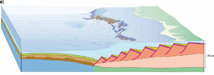
FIGURE 2.2 Block diagram of magma-poor rifted margins. (a) The top diagram illustrates the classical representation of pre-, syn-, and postrift sediments over uniformly stretched continental crust, with high-angle normal faults in the upper crust and ductile deformation in the lower crust. Sedimentary basins formed during the deformation are all of the same age. (b) The bottom diagram illustrates a modern representation of the complex architecture at the ocean-continent transition. This architecture is acquired during multiple phases of deformation that begin with high-angle faulting, followed by extreme crustal thinning, mantle exhumation, and finally, seafloor spreading. Sedimentary basins formed during polyphase deformation are distinctly different in age. SOURCE: Modified from Péron-Pinvidic and Manatschal, 2009.
of continental breakup included single expeditions in the Tyrrhenian Sea (ODP Leg 107), Broken Ridge (ODP Leg 120), and Woodlark Basin (ODP Leg 180). Three of the seven sites drilled in ODP Leg 107 reached basalt-floored basins; varying age dates of those basalts supported the hypothesis that they were emplaced during extension (Kastens et al., 1987, 1988). One of the sites (ODP Site 651A) drilled mantle-derived, serpentinized peridotite (Kastens and Mascle, 1990). ODP Leg 180 sought to drill an active, low-angle normal fault thought to play a major role in the thinning of continental crust, the formation of the Moresby Seamount, and the formation of the Woodlark Basin (Taylor and Huchon, 2002). ODP Leg 120 was designed to study the origin and tectonic history of the Kerguelen Plateau, a large igneous province (Schlich et al., 1989). Preliminary drilling results reported no evidence for a continental origin of the plateau
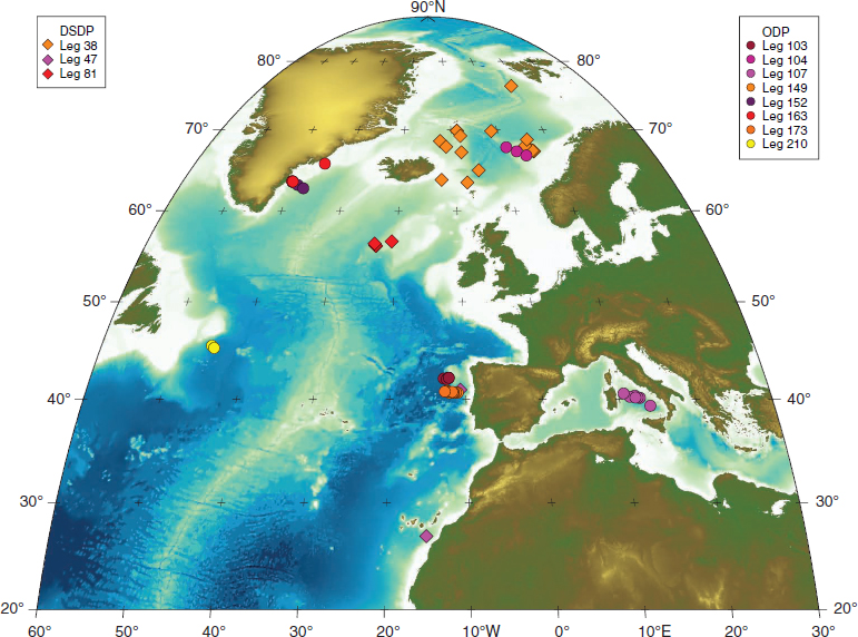
FIGURE 2.3 Location map of DSDP and ODP legs related to rifting margins. This is a Mollweide (equal area) projection with a color range of -9,000 to 9,000 m, with white marking the 0 m depth. SOURCE: IODP-USIO.
(Schlich and Wise, 1992); however, subsequent geochemical and geophysical studies have suggested that the Kerguelen Plateau is indeed composed of remnants of Indian-Antarctic continental crust that interacted with the Kerguelen Plume (e.g., Bénard et al., 2010). The evolving interpretation of this feature is typical of the integrated, multidisciplinary studies that have allowed new paradigms for continental breakup to progress. In summary, all of these expeditions added elements to the evolving understanding of continental breakup processes, but none had sufficient coverage to fully illuminate the story at any single margin.
Fields of Inquiry Enabled
The discovery of exhumed mantle during drilling expeditions along the Iberian Margin prompted extensive reinterpretation of existing seismic data and acquisition of several additional multichannel seismic profiles, designed to provide regional mapping context for the drilled horizons (Péron-Pinvidic et al., 2007). Those new interpretations were subsequently coupled with geodynamic models, shallow drilling by European research groups, and a synthesis of analogs from the Alps and relevant mid-ocean ridges to evolve the new paradigms for continental breakup (Lavier and Manatschal, 2006; Péron-Pinvidic and Manatschal, 2009; Unternehr et al., 2010). The integration of these multidisciplinary studies over several decades provides an excellent example of a case where scientific ocean drilling was part of an iterative process that also required both onshore and offshore geophysical and geologic calibration and validation, and geodynamic modeling.
The formation of magma-rich margins and associated LIPs has also recently been linked to biotic events and dipole reversal frequency, especially in the case of the North Atlantic and associated SDRs (Eldholm and Thomas, 1993) and the Paleocene-Eocene Thermal Maximum event (ODP Hole
690B; Kennett and Stott, 1991; Bains et al., 1999; Svensen et al., 2004). Though controversial, this example serves as a model for the initiation of other LIPs (see last section in this chapter for additional detail).
Goals Not Yet Accomplished
The study of rifted margins is critical to understanding continental breakup processes, plate kinematic reconstructions, and prediction of hydrocarbon resource distribution. In addition, the formation of volcanic margins may be intimately related to climatic events, biotic events, and dipole reversal frequency. When the IODP Initial Science Plan (2001) was written, key elements of the new paradigm for continental rifting were in place, but the number of margins along which key sedimentary sequences were accessible by riserless drilling was limited. The Continental Breakup and Sedimentary Basin Formation initiative was aimed at answering remaining fundamental science questions via riser drilling using Chikyu. However, riser drilling of rifted margins was not accomplished in IODP for a variety of reasons. One of these was the two- to three-year delay in the delivery of Chikyu, which decreased the amount of time available for expeditions. IODP scientists cite this technical area as one where the objectives of the IODP Initial Science Plan were not achieved as planned (Keir Becker, PowerPoint presentation, June 2010).
Future improvements to the understanding of continental rifted margins will depend not only on scientific ocean drilling, but also on high-quality seismic reflection profiles and companion long-offset seismic surveys, which creates an opportunity for collaboration between academia and industry. U.S. scientists have recently finalized plans for a new initiative on rifted margins as part of the NSF-funded GeoPRISMS (Geodynamic Processes at Rifting and Subducting Margins) Program (GeoPRISMS, 2011).
SUBDUCTION ZONE PROCESSES AND THE SEISMOGENIC ZONE
Subduction zones, where one tectonic plate plunges beneath another, are the source of some of Earth’s greatest natural hazards. These areas are also where new continental crust is formed. Scientific ocean drilling plays a key role in a range of multidisciplinary studies of volcanic processes, particularly with regard to formation of new continental crust in volcanic arcs. The knowledge derived from these studies is essential for developing practical predictive models and warning systems to protect the inhabitants of volcanic regions from eruptions and associated hazards, such as mudflows and tsunamis. Past targets have included drill sites devoted to determining the composition of subducted material, the manner in which material is accreted to the overriding plate and incorporated into volcanic arcs, and the chemistry of material that is subducted and then extruded through forearc mud volcanoes. In 2008, a new IODP program (SEIsmogenic Zone Experiment [SEIZE]) was initiated to drill through the plate boundary at a seismogenic depth, thus contributing to the understanding of mechanisms that control whether a plate boundary fault slides slowly or becomes locked, episodically generating great earthquakes (magnitude 8.0 or larger).
Scientific Accomplishments and Significance
Determining the nature of the crust, sediments, and pore water entering a subduction zone has been the primary objective at several DSDP, ODP, and IODP sites, because the distinctive composition of material that is subducted acts as a tracer of the processes at depth that lead to arc volcanism (Plank and Langmuir, 1993, 1998). Studies have evolved from identification of elements that can be used as tracers for modeling and constructing mass-balance budgets of inputs and outputs of material across a subduction zone.
Sampling from a number of different subduction zones revealed a correlation between the composition of sediments being subducted and the composition of the extruded basalts. Analysis of lithium isotopes from ODP Site 1039 suggests that half of the lithium in the down-going plate offshore Costa Rica is transferred to the arc, one-quarter returns to the ocean through fluid expulsion along the decollement, and one-quarter may be recycled into the mantle (Chan and Kastner, 2000). However, in other subduction zones (e.g., Kamchatka), a lack of correlation between sediment input to the subduction zone and the arc output in some regions implies that at least in some subduction zones none of the subducted sediment and crust reaches the deep interior to be reworked and incorporated in the zone of melt generation (Kersting and Arculus, 1995).
In some arcs, most notably in the Marianas, material extruded into the forearc through mud volcanoes provides a direct window into hidden processes that operate deep within the subduction zone. ODP Legs 125 and 195 provided samples of unusual minerals and freshened pore fluids derived from interaction of subducted sediments and crust with the overlying forearc mantle (Maekawa et al., 1993; Fryer et al., 1995, 1999). During ODP Leg 195, a long-term borehole observatory was installed in a serpentine seamount in order to examine mass transport, geochemical cycling, and physical, chemical, and microbial fluid characteristics.
Drilling also played a critical role in the realization that crustal erosion, as well as accretion, occurs in forearcs. Subduction erosion results in forearc subsidence and formation of large basins and deep terraces, subduction of crystalline forearc crust to depths at which arc magmas form, and trench retreat and arc migration. Although previous studies noted that a considerable amount of forearc material was missing from the Japan and Peru-Chile trenches and attributed it to the subduction of forearc crust (e.g., Miller, 1970a,b; Murauchi, 1971; Rutland, 1971), it was not until DSDP
Legs 56 and 57, when drilling results were combined with a network of site survey seismic reflection and refraction profiles, that a detailed model for tectonic erosion and its impact on forearc subsidence was developed (von Huene et al., 1980). Evidence of erosion of the upper plate has also been documented by scientific ocean drilling off Guatemala (DSDP Legs 67 and 84), Peru (ODP Leg 112), Tonga (ODP Leg 135), and Costa Rica (ODP Leg 170 and IODP Expedition 334). It is likely that most arcs experience episodes of subduction erosion as well as accretion (von Huene and Scholl, 1991), with implications for megathrust earthquake hazard and continental evolution (Stern, 2011).
Drilling has also provided some unique information on arc histories through recovery of well-preserved ash sequences (Figure 2.4). For example, cores from several DSDP and ODP legs (e.g., ODP Legs 125 and 126) yield a nearly complete 45 myr record of arc volcanism in the Mariana-Izu arc (e.g., Arculus et al., 1995). These studies demonstrated that the Mariana and Izu arc systems shared similar chemical behavior from 30 to 15 myr ago, diverging about 12 myr ago (Plank, 2002). Although the reason for the initial similarity and later change are not yet well known, the ash sequences provide an intriguing look at evolution of arc volcanism over time. Other ash studies from cores on the Caribbean Plate (ODP Leg 165) document the episodicity of explosive volcanism in Central America and indicate that some eruptions in this region rivaled the largest super-eruptions known in the geologic record.
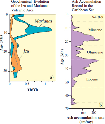
FIGURE 2.4 Arc history in the Southwest Pacific (a) and Caribbean (b) as recorded by cored ash layers. Changes in isotopic ratios with time in the southwest Pacific provide fingerprints of changes in deep magmatic systems. In the Caribbean, changes in ash accumulation rate indicate temporal changes in volcanic vigor through the Cenozoic. SOURCE: Plank, 2002.
Recent accomplishments in understanding subduction zones have been under the aegis of the SEIZE program, which is designed to understand the processes that result in great earthquakes at subduction zones. IODP efforts to date have been focused on the Nankai Trough, offshore southeast Japan, which has a long history of earthquakes with magnitude 8.0 or larger.1 Reaching NanTroSEIZE’s ultimate objective of sampling the plate boundary at seismogenic depth (Box 2.4) requires the riser drilling capability of the Chikyu and has been the major component of the Japanese contribution to IODP in recent years. One important result thus far is the identification of a branching fault that reaches the seafloor at a steeper angle than the main thrust fault of the subduction zone system and may be responsible for the large, historic tsunamis that have affected this region (Moore et al., 2007; Bangs et al., 2009). Others include confirmation of recent activity on the fault from Pliocene sediments thrust over Pleistocene sediments, and indications of frictional heating from vitrinite (a component of coal) reflectance, related to high-velocity slip along a narrow fault plane (Sakaguchi et al., 2011).
Fields of Inquiry Enabled
Documenting the materials that enter subduction zones is critical for a wide range of studies. Scientific ocean drilling is the only way to determine the composition of sediments and uppermost crust entering the trench and to calibrate seismically based estimates of upper plate erosion. Some of this sediment is accreted or underplated to the forearc, and some is subducted to great depth, providing volatiles that stimulate magmatic production in the arc, in proportions that are likely controlled by both sediment thickness and composition. Understanding this partitioning has implications for studies of arc magmatism, forearc structure and geohazards, and the formation of new continental crust. Documenting the occurrence of subduction erosion transformed estimates of crustal mass balance along active continental margins and provided a mechanism to explain marine observations of forearc basin subsidence and terrestrial observations of continent-ward migration of active volcanic arcs. Sediment subduction and subduction erosion may also affect the frictional properties of the plate boundary.
Although most knowledge about faulting processes is obtained from seismological and geodetic instruments and
_____________
1 The Nankai Trough NanTroSEIZE site is about 500 km away from the epicenter of the magnitude 9.0 TShoku earthquake of 2011, which was located on the Japan Trench.
modeling, scientific ocean drilling is required to sample fault plane materials at the depths at which earthquakes nucleate and to measure temporal changes in physical properties associated with a changing state of stress. Observatory installations at these depths (see Box 3.2), coupled with real-time data delivery systems, have the potential to support practical earthquake early-warning systems as well as to provide new scientific insights into earthquake processes. Such observatories can measure in situ temperature, pore pressure, and strain, and could include other parameters as new tools are developed.
Goals Not Yet Accomplished
Some of the major unknowns about subduction zone earthquakes (and plate-bounding faults in general) are the characteristics controlling locked faults with infrequent large earthquakes vs. those with slow, aseismic slip. Deep drilling in forearc mud volcanoes promises to provide the most direct link to geochemical processes at depth in the forearc. Obtaining in situ, unaltered samples will provide scientists information on physical properties of the material, which is needed to test models of subduction zone processes and earthquake genesis. Installation of instruments to measure temperature, seismic waves, strain, pressure, fluid flow, and pore water chemistry at these depths are planned for the future.
Achieving the ambitious goals of SEIZE remains a challenge, with questions about the feasibility of deep drilling because of strong currents in the area, tool and instrument performances at high temperature, and the time and cost to drill to such great depth. The delay in being able to use the Chikyu also impacted the project timeline. The broad spectrum of onshore and offshore geophysical and geochemical observations required to further understand subduction zones and their associated geohazards, makes this area of research ideal for coordination between scientific ocean drilling and other programs (for example, GeoPRISMS, EarthScope, U.S. Geological Survey [USGS] hazards initiatives). Technological advances are also needed to improve sediment recovery in sandy sediments, and thus provide longer paleoseismic records. Deeper and more complete turbidite and ash records from additional arcs will increase understanding of arc histories, which will contribute to a predictive understanding of why some arcs are very explosive and generate mega-eruptions with global impact.
Large igneous provinces are areas on Earth’s surface that are covered with large volumes of volcanic and plutonic rocks, widely recognized as being related to mantle plumes or hotspots (see global distributions in Figure 2.5). In most places, they formed from large accumulations of mafic magma produced by large-volume melting over short time intervals (often no more than 2-3 myr; Coffin et al., 2006). Lava flows in oceanic LIPs encompass vast areas, reaching tens of thousands of square kilometers with thicknesses of a few to hundreds of meters. Oceanic LIPs are among the largest outpourings of materials from Earth’s interior during a short-lived event (e.g., Tolan et al., 1989), with overall volumes that fall in the range of 103 to 106 km3, yielding abnormally thick ocean crust of up to ~40 km (Gladczenko et al., 1997; Richardson et al., 2000; Miura et al., 2004; Kerr and Mahoney, 2007). They represent about 10 percent of the mass and energy flux from Earth’s deep interior (e.g., Sleep, 1992) and have a large impact on ocean chemistry, climatic conditions, and even the trajectory of evolution and extinction of life forms. However, precisely how LIPs form remains a subject of great debate, with possibilities of origin including plume activity, bolide impacts, massive upwelling of eclogite, and lithospheric delamination.
Scientific Accomplishments and Significance
Sampling oceanic LIPs remains more difficult than accessing their continental counterparts, because of their inaccessibility and burial beneath marine sediments. Only four submarine LIPs have been drilled thus far: the 55 Ma North Atlantic Volcanic Province on ODP Leg 104 (e.g., Storey et al., 2007), the ~120 Ma Ontong Java Plateau on DSDP Leg 30 (e.g., Packham and Andrews, 1975) and ODP Leg 192 (e.g., Tejada et al., 2004), the 120-95 Ma Kerguelen Plateau/ Broken Ridge on ODP Leg 183 (e.g., Frey et al., 2000), and the ~145-130 Ma Shatsky Rise on ODP Leg 198. In some cases where sediments completely blanket the underlying igneous rock, scientific ocean drilling has provided the only direct samples that have ever been collected (e.g., Neal et al., 2008). Although LIPs are tens of kilometers thick, the cores recovered thus far have been limited to only a few tens to hundreds of meters because of the difficulty of penetrating through thick sequences of crystalline rock.
DSDP drilling of the North Atlantic volcanic province for seaward-dipping reflectors (previously discussed in the continental breakup section) provided evidence that SDRs were subaerially erupted basalts that subsided below sea level. Dating of cores correlated the eruption of the North Atlantic Igneous Province with the Paleocene-Eocene Thermal Maximum (PETM), a period of rapid global climate warming. This led to hypotheses that the climatic and volcanic events are causally related and confirmed that submarine LIPs are formed in geologically short timespans.
ODP drill cores from the Kerguelen/Broken Ridge LIP revealed pieces of wood and sediment, confirming that some areas reached above the sea surface as islands before being submerged (Coffin et al., 2000). Drilling on ODP Leg 192 suggested that the Ontong Java Plateau was formed almost entirely beneath the sea surface, unlike the Kerguelan Plateau (Mahoney et al., 2001). Sampling 149 m into the basement at ODP Site 807 found basalt geochemistry indicative of high degrees of melting (Frey et al., 2000), with fairly uniform
Box 2.4
NanTroSEIZE
Eight NanTroSEIZE expeditions were completed between 2008 and 2010.1 Stage 1, completed in February 2008, was a transect of eight sites that targeted the shallow part of the accretionary complex, providing information on stresses, pore water geochemistry, and sediment age, lithology, and physical properties (see white paper by Casey Moore, Appendix C). Results from the three Stage 1 expeditions were reviewed by Kinoshita et al. (2009). Stage 2, completed in October 2009, characterized the sediments on the subducted slab and prepared the stage for drilling a deep-riser hole through the megasplay fault and decollement. Stage 3 began in August 2010 and entails riser drilling to a depth of 6,000-7,000 m beneath the seafloor to penetrate several active fault zones and the crust of the subducting plate (see Figure below). Stage 4 is the planned installation of a long-term observatory to measure fluid pressure, seismicity, strain, tilt, and temperature within the ultra-deep boreholes drilled during Stage 3 and to transmit the data in real time.
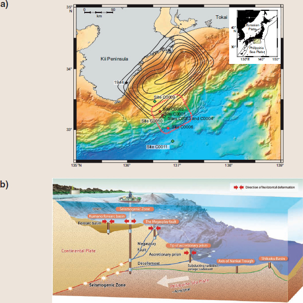
(a) Map of the NanTroSEIZE transect. The epicenter and contours of seismic slip for the magnitude 8.1 tsunamigenic earthquake of 1944 are also shown (from McNeil et al., 2010). (b) Schematic illustration of the NanTroSEIZE transect (SOURCE: © JAMSTEC).
________
1 See http://www.jamstec.go.jp/chikyu/eng/Expedition/NantroSEIZE/.
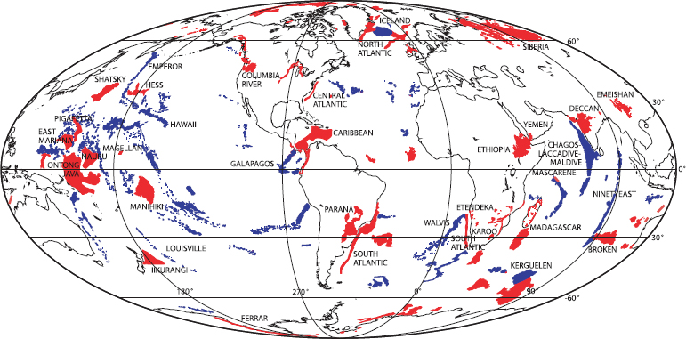
FIGURE 2.5 Phanerozoic global LIP distribution. Red areas are LIPs (or portions thereof) generated by a transient “plume head”; blue areas are LIPs (or portions thereof) generated by a persistent “plume tail.” SOURCE: Modified from Coffin et al., 2006.
compositions (Mahoney et al., 2001). Although oceanic LIPs are composed mainly of tholeiitic basalts similar to mid-ocean ridge basalts, they have higher concentrations of large ion lithophile elements, which likely reflect not only the compositional source of the basalt but also differentiation processes in the magma prior to eruption. Unlike other LIPs, the submarine emplacement of the Ontong Java Plateau may have lessened its impact on the climate.
The Shatsky Rise expedition (ODP Leg 198) recovered an excellent series of sedimentary cores, with evidence for ocean anoxic events, the PETM, and the K-T boundary, but was less successful penetrating the basement of the LIP itself (Bralower et al., 2002).
Fields of Inquiry Enabled
LIPs provide a context to understand mantle variability and plume dynamics, the origin of mass extinction, and continental breakup events. Scientific ocean drilling provides opportunities to study how the geochemical composition of magmas changes over time, relationships to melting anomalies that cause LIPs, and the timing and rate of eruptions. However, it also provides an opportunity to understand the complex interplay between volcanic, climatic, and biotic processes.
Two other fields of inquiry that have benefited from the study of massive submarine LIPs are ocean anoxia events and volcanic eruption-related climate change. LIPs have been identified as potential triggers of oceanic anoxia, now recognized to be accompanied by the deposition of organic-rich black shales. LIP eruptions could also release massive amounts of aerosols and greenhouse gases, especially carbon dioxide, methane, and sulfur dioxide. Research into the cause and effect relationships between this type of massive volcanism and changes in climate has grown significantly with the emergence of data from both continental and oceanic LIPs. LIPs may have also played an important role in massive extinctions.
Goals Not Yet Accomplished
Sampling LIPs by drilling has been likened to “pin-pricking an elephant,” as LIPs are considerably thicker than the deepest cores recovered thus far. Those cores, in the 800-900 m range from the Kerguelen Plateau, only cover a fraction of the estimated 30 km thickness of the LIP (Operto and Charvis, 1995). Deeper drilling into the basement of these provinces would offer further opportunity to understand their emplacement, age, and geochemical variability.
More thorough drilling of submarine LIPs could improve understanding of LIP genesis and emplacement, because there is no single model that currently satisfies all observations. In addition, thorough dating could provide stronger evidence of potential linkages between LIP eruptions and mass extinctions. Other issues that scientific ocean drilling could address include the initiation and duration of oceanic LIP melting events, the impact on ocean chemistry and sea-floor geochemistry, and the temporal and spatial relationships between LIPs and ocean anoxic events.


