National Academies Press: OpenBook

Global Navigation Satellite Systems: Report of a Joint Workshop of the National Academy of Engineering and the Chinese Academy of Engineering (2012)

Chapter: Impact of Intentional, Low Power, In-Band, Personal Privacy Devices (PPDs) on Aviation--A.J. Van Dierendonck

« Previous: Analysis of the GNSS Augmentation Technology Architecture--Chen Jinping
Suggested Citation:"Impact of Intentional, Low Power, In-Band, Personal Privacy Devices (PPDs) on Aviation--A.J. Van Dierendonck." National Academy of Engineering. 2012. Global Navigation Satellite Systems: Report of a Joint Workshop of the National Academy of Engineering and the Chinese Academy of Engineering. Washington, DC: The National Academies Press. doi: 10.17226/13292.
×

Impact of Intentional, Low Power, In-Band, Personal Privacy Devices (PPDs) on Aviation

A.J. VAN DIERENDONCK
AJ Systems
Los Altos, California


What are PPDs? PPDs are small “jammers” that plug into cigarette lighter sockets that are meant to “jam” or “mask” Global Positioning System (GPS)-Global Navigation Satellite Systems (GNSS) receiver/navigators that report, through other means, the position of the host vehicle, when the user does not want his position known. Use is illegal in the United States. They are probably purchased via the Internet. Unknown (or known) to the owner, PPDs can jam other users of GPS (GNSS), including Safety-of-Life (SOL) operations. At Newark, New Jersey, airport (EWR), such a device’s radio frequency interference (RFI) affected the Ground-Based Augmentation System (GBAS) operation. GBAS performance interruptions have been observed since November 2009, impacting GBAS service availability, although there was no evidence of direct effects on airborne avionics. It was determined that RFI emanated from sources on the New Jersey Turnpike (NJT) (in motion). A test program determined direction of travel, average velocity, how frequently emitter(s) traveled past the EWR GBAS, and what time of day and days of the week events were observed.

RFI was also detected at Wide Area Augmentation System (WAAS) Reference Stations (WRSs) near Washington, D.C., and Houston, Texas. However, because of diverse location and redundancy of WAAS reference receivers, no interruptions of WAAS operations were noticed.

RFI was characterized by analyzing data collected from GPS receivers, spectrum analyzers, and time samples captured by real time data collection (snapshots). Through measurements of spectral shape, time series demodulation, magnitude of degradation in GPS receivers, and estimates of emitter(s) transmitted

Suggested Citation:"Impact of Intentional, Low Power, In-Band, Personal Privacy Devices (PPDs) on Aviation--A.J. Van Dierendonck." National Academy of Engineering. 2012. Global Navigation Satellite Systems: Report of a Joint Workshop of the National Academy of Engineering and the Chinese Academy of Engineering. Washington, DC: The National Academies Press. doi: 10.17226/13292.
×

power, RFI was characterized. The fact that the interference source was moving complicated the characterization.

THE SCENARIO AT EWR

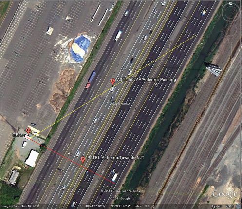
NJT runs by the GBAS facilities (Figure 1). There was intermittent severe degradation or loss-of-lock in GBAS reference receivers. There were also additional GPS receivers/antennas installed at the GBAS shelter to record more detailed information when severe GBAS degradation was noted—one antenna with moderate directivity that was pointing horizontal northward along NJT, and one omni-directional pointing up. Of course, received interference power was greatest during the closest approach of the interference source. This resulted in negative elevation angles, so gain was low, but approximate azimuth direction could be observed.

The spectral peak of Antenna 1 is observed at GPS TOW1 (GPS Time of Week of event 1); the spectral peak of Antenna 2 is observed at GPS TOW2
image

FIGURE 1 The scenario at EWR.

Suggested Citation:"Impact of Intentional, Low Power, In-Band, Personal Privacy Devices (PPDs) on Aviation--A.J. Van Dierendonck." National Academy of Engineering. 2012. Global Navigation Satellite Systems: Report of a Joint Workshop of the National Academy of Engineering and the Chinese Academy of Engineering. Washington, DC: The National Academies Press. doi: 10.17226/13292.
×

(event 2). The average speed is based upon the time difference. Google Earth images of 654 meters at 33° places RFI in the NJT southbound lane 5.

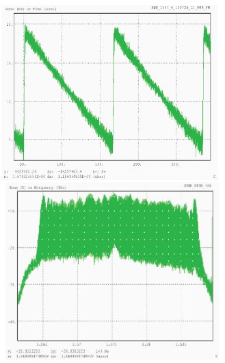
Multiple emitter types were observed (Figure 2). A linear sweep indicates that the underlying signal for this particular event is swept CW, starting at 1570 MHz and increasing to 1590 MHz in about 116 microseconds (8.6 kHz sweep rate). The small increase in the center of the band is GPS coarse/acquisition code.

OBSERVED L1 C/N0 DEGRADATION—RFI POWER ESTIMATES

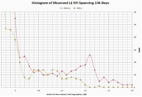
Figure 3 presents a histogram of Normalized Measurements of C/N0 (L1 Carrier Power-to-Noise Density ratio) from a WAAS G-II Receiver that
image

FIGURE 2 Typical wideband RFI.

Suggested Citation:"Impact of Intentional, Low Power, In-Band, Personal Privacy Devices (PPDs) on Aviation--A.J. Van Dierendonck." National Academy of Engineering. 2012. Global Navigation Satellite Systems: Report of a Joint Workshop of the National Academy of Engineering and the Chinese Academy of Engineering. Washington, DC: The National Academies Press. doi: 10.17226/13292.
×

image

FIGURE 3 WAAS G-II normalized C/N0 degradation (dB).

was developed covering 146 days. The events were recorded whenever loss-of-lock or severe degradation occurred in the GBAS Reference Receiver. The magnitude of degradation varied more than 20 dB, greater than the uncertainty with respect to Free-Space-Loss (FSL).

The estimated RFI power variation due to measurement accuracy is minimal—approximately ±1 dB RSS. The estimated RFI power variation due to other uncertainties is significant—transmit antenna gain and the loss exiting the vehicle, and the exact location of RFI transmitter (10 to 11 dB). The polarization mismatch loss uncertainty is 1 to 6 dB. Note that most of the degradations were less than about 8 dB, but a significant number had a degradation of 21 dB.

THE SCENARIO NEAR WAAS REFERENCE STATIONS AT LEESBURG, VIRGINIA, AND HOUSTON, TEXAS

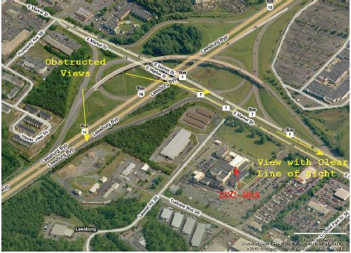
Figure 4 shows a scenario near the WAAS Reference Station (WRS) at Leesburg, Virginia, showing highways relative to the ZDC-WRS. Figure 5 shows the degradation of Houston WAAS Reference Receiver normalized C/N0 versus time-of-day, occurring twice each day. It is postulated that the vehicle passed by on the airport access road to the airport, and then returned later. Similar degradations were observed at the ZDC-WRS.
Suggested Citation:"Impact of Intentional, Low Power, In-Band, Personal Privacy Devices (PPDs) on Aviation--A.J. Van Dierendonck." National Academy of Engineering. 2012. Global Navigation Satellite Systems: Report of a Joint Workshop of the National Academy of Engineering and the Chinese Academy of Engineering. Washington, DC: The National Academies Press. doi: 10.17226/13292.
×

image

FIGURE 4 ZDC-WRS location relative to roads passing by.

SUMMARY

Aviation must consider PPD proliferation as inevitable. The key uncertainty in the presented results is the radiation pattern for emitter(s) installed in a vehicle. It is highly dependent on the structure of the vehicle and location of the RFI transmitter within the vehicle, which is not easily modeled. GNSS ground RF operating environment requirements may have to be improved by “hardening” from sighting and operational considerations. However, is 15–25 dB improvement even possible?

We must evaluate implications for avionics. No interruptions of GPS reception by avionics have been reported to date. Should the Avionics Minimum Operational Performance Standards (MOPS) RFI mask address unintentional intentional emitters, while retaining the aggregate of –110.5 dBm/Hz within +/– 10 MHz? Should we add an A/J requirement to MOPS?

Suggested Citation:"Impact of Intentional, Low Power, In-Band, Personal Privacy Devices (PPDs) on Aviation--A.J. Van Dierendonck." National Academy of Engineering. 2012. Global Navigation Satellite Systems: Report of a Joint Workshop of the National Academy of Engineering and the Chinese Academy of Engineering. Washington, DC: The National Academies Press. doi: 10.17226/13292.
×

image

FIGURE 5 Degradation of normalized C/N0 versus GPS time-of-day (in seconds) at Houston WRS.

Suggested Citation:"Impact of Intentional, Low Power, In-Band, Personal Privacy Devices (PPDs) on Aviation--A.J. Van Dierendonck." National Academy of Engineering. 2012. Global Navigation Satellite Systems: Report of a Joint Workshop of the National Academy of Engineering and the Chinese Academy of Engineering. Washington, DC: The National Academies Press. doi: 10.17226/13292.
×
Page 147
Suggested Citation:"Impact of Intentional, Low Power, In-Band, Personal Privacy Devices (PPDs) on Aviation--A.J. Van Dierendonck." National Academy of Engineering. 2012. Global Navigation Satellite Systems: Report of a Joint Workshop of the National Academy of Engineering and the Chinese Academy of Engineering. Washington, DC: The National Academies Press. doi: 10.17226/13292.
×
Page 148
Suggested Citation:"Impact of Intentional, Low Power, In-Band, Personal Privacy Devices (PPDs) on Aviation--A.J. Van Dierendonck." National Academy of Engineering. 2012. Global Navigation Satellite Systems: Report of a Joint Workshop of the National Academy of Engineering and the Chinese Academy of Engineering. Washington, DC: The National Academies Press. doi: 10.17226/13292.
×
Page 149
Suggested Citation:"Impact of Intentional, Low Power, In-Band, Personal Privacy Devices (PPDs) on Aviation--A.J. Van Dierendonck." National Academy of Engineering. 2012. Global Navigation Satellite Systems: Report of a Joint Workshop of the National Academy of Engineering and the Chinese Academy of Engineering. Washington, DC: The National Academies Press. doi: 10.17226/13292.
×
Page 150
Suggested Citation:"Impact of Intentional, Low Power, In-Band, Personal Privacy Devices (PPDs) on Aviation--A.J. Van Dierendonck." National Academy of Engineering. 2012. Global Navigation Satellite Systems: Report of a Joint Workshop of the National Academy of Engineering and the Chinese Academy of Engineering. Washington, DC: The National Academies Press. doi: 10.17226/13292.
×
Page 151
Suggested Citation:"Impact of Intentional, Low Power, In-Band, Personal Privacy Devices (PPDs) on Aviation--A.J. Van Dierendonck." National Academy of Engineering. 2012. Global Navigation Satellite Systems: Report of a Joint Workshop of the National Academy of Engineering and the Chinese Academy of Engineering. Washington, DC: The National Academies Press. doi: 10.17226/13292.
×
Page 152
Next: GNSS Open Signals Interference Issues and Countermeasures--Du Xiaodong, Wang Feixue, and Nie Junwei »
Global Navigation Satellite Systems: Report of a Joint Workshop of the National Academy of Engineering and the Chinese Academy of Engineering Get This Book
×
 Global Navigation Satellite Systems: Report of a Joint Workshop of the National Academy of Engineering and the Chinese Academy of Engineering
Buy Paperback | $65.00 Buy Ebook | $54.99
MyNAP members save 10% online.
Login or Register to save!
Download Free PDF

The Global Positioning System (GPS) has revolutionized the measurement of position, velocity, and time. It has rapidly evolved into a worldwide utility with more than a billion receiver sets currently in use that provide enormous benefits to humanity: improved safety of life, increased productivity, and wide-spread convenience. Global Navigation Satellite Systems summarizes the joint workshop on Global Navigation Satellite Systems held jointly by the U.S. National Academy of Engineering and the Chinese Academy of Engineering on May 24-25, 2011 at Hongqiao Guest Hotel in Shanghai, China.

"We have one world, and only one set of global resources. It is important to work together on satellite navigation. Competing and cooperation is like Yin and Yang. They need to be balanced," stated Dr. Charles M. Vest, President of the National Academy of Engineering, in the workshop's opening remarks. Global Navigation Satellite Systems covers the objectives of the workshop, which explore issues of enhanced interoperability and interchangeability for all civil users aimed to consider collaborative efforts for countering the global threat of inadvertent or illegal interference to GNSS signals, promotes new applications for GNSS, emphasizing productivity, safety, and environmental protection.

The workshop featured presentations chosen based on the following criteria: they must have relevant engineering/technical content or usefulness; be of mutual interest; offer the opportunity for enhancing GNSS availability, accuracy, integrity, and/or continuity; and offer the possibility of recommendations for further actions and discussions. Global Navigation Satellite Systems is an essential report for engineers, workshop attendees, policy makers, educators, and relevant government agencies.

READ FREE ONLINE

  1. ×

    Welcome to OpenBook!

    You're looking at OpenBook, NAP.edu's online reading room since 1999. Based on feedback from you, our users, we've made some improvements that make it easier than ever to read thousands of publications on our website.

    Do you want to take a quick tour of the OpenBook's features?

    No Thanks Take a Tour »
  2. ×

    Show this book's table of contents, where you can jump to any chapter by name.

    « Back Next »
  3. ×

    ...or use these buttons to go back to the previous chapter or skip to the next one.

    « Back Next »
  4. ×

    Jump up to the previous page or down to the next one. Also, you can type in a page number and press Enter to go directly to that page in the book.

    « Back Next »
  5. ×

    Switch between the Original Pages, where you can read the report as it appeared in print, and Text Pages for the web version, where you can highlight and search the text.

    « Back Next »
  6. ×

    To search the entire text of this book, type in your search term here and press Enter.

    « Back Next »
  7. ×

    Share a link to this book page on your preferred social network or via email.

    « Back Next »
  8. ×

    View our suggested citation for this chapter.

    « Back Next »
  9. ×

    Ready to take your reading offline? Click here to buy this book in print or download it as a free PDF, if available.

    « Back Next »
Stay Connected!