
2
Assessing Progress Toward the Decadal Vision
Pre-decadal survey missions—those already in orbit and those in the pipeline—served as the foundation on which the 2007 decadal survey’s priorities were established. However, the period from mid-2004 though late 2006, the approximate period when survey members were gathering information and formulating recommendations, was notable for budgetary changes that resulted in the rapid deterioration of this foundation.1 In the time since the report’s release in January 2007, this foundation has continued to erode with the loss of the Orbiting Carbon Observatory (OCO) and Glory missions and the necessity to accommodate further budget shortfalls and cost growth in pre-decadal survey missions still in development. In spite of these setbacks, NASA has made substantial progress on several of the missions that were in development at the time of the survey’s release, including the successful launches of the Ocean Surface Topography mission in 2008, as well as Aquarius and the NPOESS Preparatory Project (NPP) in 2011. This chapter summarizes progress toward the 2007 decadal survey’s vision through NASA’s extended missions, pre-decadal survey missions, implementation of the recommended decadal survey missions, and other key program elements including Climate Continuity missions, Earth Venture missions, the Applied Sciences Program, the suborbital program, technology development, and the research and analysis program.
1“Finally, participants in the survey were challenged by the rapidly changing budgetary environment of NASA and NOAA environmental satellite programs. By definition, decadal surveys are forward-looking documents that build on a stable foundation of existing and approved programs. In the present survey, the foundation eroded rapidly over the course of the study in ways that could not have been anticipated. The recommended portfolio of activities in this survey tries to be responsive to those changes, but it was not possible to account fully for the consequences of major shocks that came very late in the study, especially the delay and descoping of the NPOESS program, whose consequences were not known even as this report went to press. Similarly, the committee could not fully digest the ramifications of changes in the GOES-R program of NOAA, and it was in no position to consider the implications of a possible large-scale reduction in funding and later delay of the GPM mission. GPM, a flagship mission of NASA’s Earth science program, was a central element in the baseline of programs that the decadal survey committee assumed to be in place when developing its recommendations” (National Research Council, Earth Science and Applications from Space: National Imperatives for the Next Decade and Beyond, The National Academies Press, Washington, D.C., 2007, p. xiv).
NASA satellites often continue to provide important Earth observations long after the end of their originally planned and funded mission lifetimes (Box 2.1). The biennial NASA Earth Science Senior Review is tasked with evaluating the scientific value of missions that are currently or will soon be operating beyond their planned lifetime. The Senior Review also evaluates mission performance with respect to the health of the instruments and spacecraft, cost, and relevance to national interests.2 The first Senior Review in 2005 reviewed 12 extended missions and recommended continuation of 10 and termination of 2.3 The most recent review, in 2011, evaluated 12 extended missions, with all receiving “very high marks for Scientific Merit, Scientific Relevance, and Scientific Product Maturity.”4 All 12 missions were recommended for continuation, but with reduced funding for 2 missions owing to the degradation of some measurements.
Finding: The NASA Senior Review process is working well and provides a fair and open decision pathway for considering extended-life missions in a cost-effective way.
MISSIONS IN THE PRE-DECADAL SURVEY QUEUE
The 2007 decadal survey made its recommendations for new measurements and missions based on the assumed success of NOAA and NASA missions—sometimes referred to as “foundational” missions—that were already in development with launches expected in the early part of the decade following the survey release. These included the Ocean Surface Topography Mission (OSTM), OCO, Glory, Aquarius, NPP, Landsat Data Continuity Mission (LDCM), and Global Precipitation Measurement (GPM) missions.5 In the years following the release of the survey, NASA continued to focus much of its implementation efforts on completing these foundational missions (Table 2.1).
The successful launch of OSTM in 2008 was followed by two successive disappointments, the launch failures of OCO and Glory, in February 2009 and March 2011, respectively.6 These launch failures resulted in the loss of key observations of carbon dioxide (OCO), aerosols (Glory), and total solar irradiance (Glory). Subsequently, NASA authorized a replacement mission for OCO, OCO-2, which originally was scheduled for a 2013 launch but now has an uncertain launch date following the loss of Glory, which used the same Taurus XL launch vehicle as OCO. In June 2011, Aquarius/Satélite de Aplicaciones Científicas (SAC)-D, a mission partnership between NASA and the Space Agency of Argentina (Comisión Nacional de Actividades Espaciales) to measure sea-surface salinity, was successfully launched. Aquarius is the first dedicated satellite mission for observing the global salinity field needed for climate studies. Preliminary
2The Senior Review process defines national interests as covering applied and operational (non-research) uses, including “operational uses, public services, business and economic uses, military operations, government management, policy making, nongovernmental organizations’ uses, etc.” See Appendix 2, “National Interest Panel Report,” in G. Hurtt (chair), A. Barros, R. Bevilacqua, M. Bourassa, J. Comstock, P. Cornillon, A. Dessler, G. Egbert, H.-P. Marshall, R. Miller, L. Ritchie, et al., NASA Earth Science Senior Review 2011, submitted to Dr. Michael Freilich, Director, Earth Science Division Science Mission Directorate, June 30, 2011, available athttp://www.science.nasa.gov/media/medialibrary/2011/07/22/2011-NASA-ESSR-v3-CY-CleanCopy_3x.pdf. The particular implementation of the Senior Review that is employed by NASA’s Earth Science Division is consistent with that recommended in the National Research Council report Extending the Effective Lifetimes of Earth Observing Research Missions (The National Academies Press, Washington, D.C., 2005).
3See http://modis.gsfc.nasa.gov/sci_team/meetings/200610/presentations/plenary/volz.ppt.
4See NASA, NASA Earth Science Senior Review 2011, 2011, p. 5.
5The GPM mission consisted of two spacecraft—a core spacecraft and a low-inclination orbiter.
6The two failures were attributed to the Taurus XL launch vehicle, thus creating significant uncertainty in the planning for launch vehicles for future missions for many years into the future (see in Chapter 3 the section “Access to Space”).
BOX 2.1 ONGOING CONTRIBUTIONS FROM NASA’S EARTH SCIENCE EXTENDED MISSIONS
NASA’s aging Earth science satellite fleet continues to support many advances in Earth science and applications. Some recent examples include the following:1
• Contributing to the accuracy of weather forecasts and warnings;
• Extending and improving the record of sea-level measurement through continuation of the Jason mission using the precise geodetic infrastructure maintained largely by NASA (Figure 2.1.1);
• Obtaining unique perspectives on water mass changes, including ice loss and the water stored in major river basins around the world, through continuation of the GRACE missions (Figure 2.1.2);
• Continuing the record of stratospheric ozone depletion and recovery through continuation of the Aura mission;
• Understanding the link between fires and air quality through continuation of the Terra, Aqua, and Aura missions;
• Maintaining a continuous, precise measure of the solar energy reaching Earth through continuation of the Solar Radiation and Climate Experiment (SORCE);
• Providing ongoing observations for improved hurricane prediction through continuation of the Tropical Rainfall Measuring Mission (TRMM);
• Determining the relationship between Earth’s radiation budget and cloud systems and precipitation, and characterizing clouds’ microphysics, morphology, and convection through the continuation of CloudSat;
• Collecting the only civilian high-spectral-resolution imagery available through the continuation of EO-1 and 36 bands of global multispectral environmental imagery through the Moderate Resolution imaging Spectroradiometer (MODIS) on Terra and Aqua;
• Producing a high-quality time series of global sea-surface topography through the continuation of the Ocean Surface Topography Mission (OSTM);
• Measuring cloud optical depth and cloud depth and detecting cloud occurrence through the continuation of the Cloud-Aerosol Lidarand infrared Pathfinder Satellite Observation (CALIPSO) satellite; and
• Estimating wind speed and direction over the ocean through the continuation of the Quick Scatterometer (QuikSCAT).
1See http://www.science.nasa.gov/media/medialibrary/2011/07/22/2011-NASA-ESSR-v3-CY-CleanCopy_3x.pdf.
data have shown encouraging results (Figure 2.1). In October 2011, the NPOESS Preparatory Project was successfully launched, and in December 2011 the first images from its VIIRS instrument were acquired.
LDCM is intended to replace the aging Landsat 7 mission to provide continuity of land cover measurement. Although the 2007 decadal survey recommended securing such a replacement before 2012,7 LDCM is currently slated for launch no earlier than December 2012. This delay was in part due to the congressionally directed addition of the thermal infrared sensor (TIRS) to the platform. GPM, recommended in the survey to “launch in or before 2012” to ensure continuity of precipitation measurements, is now targeted
7National Research Council, Earth Science and Applications from Space: National Imperatives for the Next Decade and Beyond, 2007, p. 6.
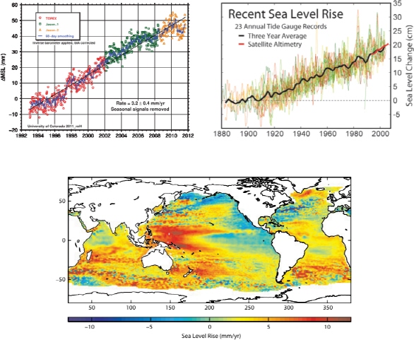
FIGURE 2.1.1 Top left: Global mean sea level from satellite altimetry observations: TOPEX/Poseidon (blue), Jason-1 (red), Jason-2 (black). Dots represent 10-day averages; curves represent 60-day smoothing. A trend of 3.2 ± 0.4 mm/year is estimated. Although slightly different results have been derived by other investigators using data products based on different processing methods, they generally fall within the quoted uncertainty of the estimate. Top right: Change in annually averaged sea level at 23 geologically stable tide gauge sites with long-term records as selected by B.C. Douglas, Global sea rise: A redetermination, Surveys in Geophysics 18:279-292, 1997. The thick dark line is a 3-year moving average of the instrumental records. For comparison, the annually averaged satellite altimetry data from TOPEX/Poseidon are shown in red. Note that the data scatter in the tide gauge measurements is ± 5 cm, whereas it is ± 0.5 cm in the altimeter measurements. Bottom: Trend in millimeters per year of regional sea level change from 1993 to 2009 based on satellite altimetry observations. SOURCE: Top left: R.S. Nerem, Global Mean Sea Level Time Series, Release 2012-1, Sea Level Research Group, University of Colorado, February 13, 2012; http://sealevel.colorado.edu/. Top right: Robert A. Rohde, Global Warming Art. Bottom: J.K. Willis, D.P. Chambers, C.-Y. Kuo, and C.K. Shum, Global sea level rise: Recent progress and challenges for the decade to come, Oceanography 23(4):26-35, 2010.
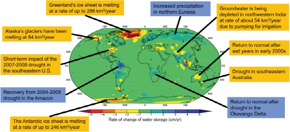
FIGURE 2.1.2 Trends in terrestrial water storage, including groundwater, soil, water, lakes, snow, and ice as observed by GRACE during 2002-2009. The GRACE mission observes changes in water storage caused by natural variability, climate change, and human activities such as groundwater pumping. Using data products based on different processing methods, other investigators have derived various estimates of these trends, but the signs of the largest trends remain quite robust. SOURCE: Courtesy of Matthew Rodell, NASA Goddard Space Flight Center; M. Rodell, J.S. Famiglietti, and D.P. Chambers, Climate-related trends, human-induced trends, and false trends in seven years of terrestrial water storage observations from GRACE, Eos Transactions, American Geophysical Union 90:(52), Fall Meeting Supplement, Abstract H11C-0810, 2009.
to launch in July 2013. In the fiscal year (FY) 2012 budget, the GPM mission was descoped to include only the core spacecraft, with development of the low-inclination orbiter canceled.
Finding: Progress in the pre-decadal survey missions has fallen short of expectations because of launch failures, delays, and changes in scope. NASA’s primary programmatic emphasis remains on flying out its pre-decadal survey mission queue.
The 2007 decadal survey was well received by NASA8 and Congress, and NASA initiated plans to implement the mission recommendations by beginning formulation studies for the first phase of survey
8For example, in testimony on March 7, 2007, before the Senate Committee on Commerce, Science and Transportation Subcommittee on Space, Aeronautics and Related Sciences, NASA’s director for the Earth Science Division, Michael Freilich, stated, “We welcome the Decadal Survey—indeed, we asked for it…. The science priorities identified by the Decadal Survey will be our primary guide as we design and select Earth observing missions to be flown in the next 10-15 years. Considering the long time horizon in the NRC’s report, it will require several budget cycles to implement the program that we will derive from the Decadal Survey’s near- and mid-term recommended mission sets. Nevertheless, our planning process starts with the consensus scientific priorities articulated
TABLE 2.1 Current Status of Pre-Decadal Survey Missions
| Mission | Launch Date | Status |
| OSTM/Jason-2 (Ocean Surface Topography Mission) |
June 2008 | Operating |
| OCO (Orbiting Carbon Observatory) |
February 2009 | Launch failure |
| Glory | March 2011 | Launch failure |
| Aquarius | June 2011 | Operating |
| NPP (NPOESS Preparatory Project) |
October 2011 | Operating |
| LDCM (Landsat Data Continuity Mission) |
Targeting December 2012 | Implementation |
| GPM Core (Global Precipitation Mission) |
Targeting July 2013 | Implementation |
| GPM LIO (Global Precipitation Mission—low inclination orbiter) |
— | Canceled |
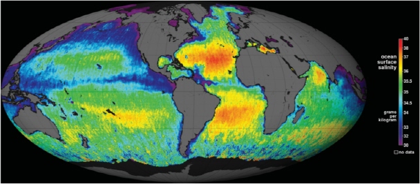
FIGURE 2.1 The first global map of the salinity of the ocean surface from the Aquarius mission, providing an early glimpse of the mission’s anticipated results. The map is a composite of the data from August 25, 2011 (the day Aquarius became operational), to September 11, 2011, and illustrates the most advanced measurement of ocean salinity from space. After further calibration and validation, this spacecraft will be able to remove some sources of error and make Aquarius measurements more accurate than those made from other platforms. SOURCE: Courtesy of NASA/GSFC/JPL-Caltech; PIA14786.
missions.9 Two of those missions, SMAP (Soil Moisture Active-Passive) and ICESat-2, have since entered into their implementation phases while the other two, DESDynI (Deformation, Ecosystem Structure, and Dynamics of Ice) and CLARREO (Climate Absolute Radiance and Refractivity Observatory), remain in formulation. The FY2012 budget significantly delays both DESDynI and CLARREO compared to the FY2011 plan, which would have had both missions enter development in 2011.10
A mission-by-mission summary of progress on each decadal survey mission recommendation is given in Table 2.2. From these data, it is clear that the survey’s recommended new measurement missions are proceeding at a considerably slower pace than recommended. The 2007 decadal survey envisioned launching three phases of missions by 2020, whereas the current NASA budget does not complete even the first phase of missions by this date. Some reasons for and consequences of this delay are explored in Chapter 3. The result is that the Earth science program and its science community face a major decline in the number of missions and the instruments in orbit, because new mission launches will not keep pace with the anticipated loss of missions already in extended operations.
Finding: Implementation of the new measurement missions recommended in the 2007 decadal survey has proceeded much more slowly than the pace originally envisioned.
Given the objective of advancing Earth system science—an objective embraced by NASA’s Earth Science Division—there is a particular need to make decisions regarding the scope, cost, and schedule of an individual mission in the context of the larger decadal survey-recommended portfolio.11 Further, absent a countervailing mechanism, there is a natural tendency for individual missions to become more responsive to single communities or disciplines rather than to the overall Earth system science community.12 For example, changes to the survey-recommended ICESat-2 mission were, in part, the result of pressures from a disciplinary community whose desires for a more advanced and capable mission than envisioned by the survey were not restrained by consideration of the budgetary impact on development of future missions
for us by the NRC.” Dr. Freilich’s full statement is available at http://www.hq.nasa.gov/legislative/hearings/. On October 25, 2009, NASA provided a written response to the recommendations of the decadal survey (an unpublished letter from Edward Weiler, Associate Administrator, NASA’s Science Mission Directorate, to Charles Kennel, Director, NRC Space Studies Board). Congressional reaction immediately following the release of the survey on January 7, 2007, included the following statement from House Science and Technology Committee Chair Bart Gordon: “At a time when accurate weather forecasting and climate research is becoming increasingly important to the well-being of our citizens, this distinguished panel of experts is warning in no uncertain terms that ‘the United States’ extraordinary foundation of global observations is at great risk’” (statement issued on January 16, 2007).
9Appendix E of this report details NASA’s response in 2009 to the recommendations made in the Earth science and applications from space decadal survey (National Research Council, Earth Science and Applications from Space: National Imperatives for the Next Decade and Beyond, 2007), as well as the agency’s status update given to the Committee on the Assessment of NASA’s Earth Science Program on April 27, 2011, at its first meeting in Washington, D.C.
10In the 2010 NASA report Responding to the Challenge of Climate and Environmental Change: NASA’s Plan for a Climate-Centric Architecture for Earth Observations and Applications from Space (available at http://nasascience.nasa.gov/earth-science/), CLARREO (the first of two mission components) and DESDynI (two spacecraft sharing a single launch vehicle) were slated for launch in 2017. The committee was informed at its first meeting on April 28, 2011, by the director of NASA’s Earth Science Division, Michael Freilich, that these plans are now on hold because the fiscal year 2012 budget does not fund mission implementation; no new target launch dates are available for these missions.
11NASA has a program executive and program scientist for each mission, and individual projects have project managers, project scientists (or principal investigators), science teams, and engineering teams; however, there is no formal coordinating mechanism across the portfolio of missions to handle decisions of cost, scope, and schedule. Instead, these are handled through individual projects, typically through reviews.
12“Where possible within budget constraints, augmentation of the specified set of science observations with additional desired observables should be considered; however, NASA and the scientific community must avoid ‘requirements creep’ and the consequent damaging cost growth” (National Research Council, Earth Science and Applications from Space: National Imperatives for the Next Decade and Beyond, 2007, p. 43).
serving different communities.13 Especially in light of austere budget projections, a large increase in the cost of a particular survey mission may threaten execution of the balanced portfolio recommended by the decadal survey.
NASA has responsibilities to all of its stakeholders, including the executive branch and Congress, which have interests in Earth observations that extend beyond those of the science and applications community whose consensus priorities are reflected in the decadal survey. From an applications standpoint, these include observations in support of policy development and long-term monitoring to document important trends in a rapidly changing Earth. In an effort to balance executive branch and congressional priorities with the community guidance set forth in the survey, NASA issued a report, Responding to the Challenge of Climate and Environmental Change: NASA’s Plan for a Climate-Centric Architecture for Earth Observations and Applications from Space,15 which convolved survey and administration priorities and took advantage of new funds made available by the executive branch to accelerate its priorities. The committee was informed that this document, which was approved by the Office of Science and Technology Policy (OSTP), the U.S. Global Change Research Program (USGCRP), and the Office of Management and Budget (OMB), now serves as the governing plan for NASA’s Earth science program.
The committee is encouraged by the inclusion in the NASA report of a new line of Climate Continuity missions that is responsive to the survey’s call for sustained observations to complement the new measurements it recommends. Through this line of missions, NASA has accepted responsibility for some sustained observations, which are especially needed in view of the demonstrated inability of NOAA to take up this mission in an operational capacity. However, the committee remains concerned that a long-term strategy for selecting and funding such measurements has yet to be established (see Chapter 4 for further discussion). Without a firm agency or multiagency plan and corresponding funding made available to accommodate sustained measurements, funding for these continuity missions must come at the expense of survey priorities for new measurements. Lack of sufficient funding in near-term budgets to cover both continuity missions and new measurement missions heightens the need to determine these priorities sooner rather than later. A process is urgently needed for deciding which measurements are to be sustained and how balance can be achieved between sustained and new measurements in the face of flat or declining budgets. (See discussion and committee recommendations in Chapter 4.)
The 2007 decadal survey recommended establishment of a new Earth Venture class of relatively low-cost research and applications missions to restore more frequent launch opportunities and facilitate demonstration of innovative ideas and higher-risk technologies. These missions were envisioned as including “stand-alone missions that use relatively simple, small instruments, spacecraft, and launch vehicles; more complex instruments of opportunity flown on partner spacecraft and launch vehicles; or complex sets of instruments flown on suitable suborbital platforms to address focused sets of scientific questions.”16
13The evolution toward more discipline-specific priorities for ICESat-2 was discussed in detail during a Committee on the Assessment of NASA’s Earth Science Program teleconference with NASA Chief Scientist Waleed Abdalati on August 8, 2011.
14The Climate Continuity missions include SAGE-III (2015), OCO-3 (2015), GRACE-FO (2016), and PACE (2019-2020).
15NASA, Responding to the Challenge of Climate and Environmental Change, 2010.
16National Research Council, Earth Science and Applications from Space: National Imperatives for the Next Decade and Beyond, 2007, p. 59.
TABLE 2.2 Current Status of Earth Science and Applications Decadal Survey Recommended Missions
| Mission | Mission Description (from 2007 decadal survey) | Recommended Launch Time Frame | Planned Launch Date | Statusa |
| CLARREO (Climate Absolute Radiance and Refractivity Observatory) |
Solar and Earth radiation; spectrally resolved forcing and response of the climate system | 2010-2013 | Noneb | Formulation (Pre-Phase A) |
| SMAP (Soil Moisture Active-Passive) |
Soil moisture and freeze-thaw for weather and water-cycle processes | 2010-2013 | November 2014 | Implementation Phase (Phase B) |
| ICESat-II | Ice sheet height changes for climate change diagnosis | 2010-2013 | October 2015 | Implementation Phase (Phase A) |
| DESDynI (Deformation, Ecosystem Structure, and Dynamics of Ice) |
Surface and ice sheet deformation for understanding natural hazards and climate; vegetation structure for ecosystem health | 2010-2013 | Noneb | Formulation (Pre-Phase A) |
| HyspIRI (Hyperspectral Infrared Imager) |
Land surface composition for agriculture and mineral characterization; vegetation types for ecosystem health | 2013-2016 | None | Formulation (Pre-Phase A) |
| ASCENDS (Active Sensing of CO2 Emissions over Nights, Days, and Seasons) |
Day/night, all-latitude, all-season CO2 column integrals for climate emissions | 2013-2016 | Nonec | Formulation (Pre-Phase A) |
| SWOT (Surface Water and Ocean Topography) |
Ocean, lake, and river water levels for ocean and inland water dynamics | 2013-2016 | Noned | Formulation (Pre-Phase A) |
| GEO-CAPE (Geostationary Coastal and Air Pollution Events Mission) |
Atmospheric gas columns for air quality forecasts; ocean color for coastal ecosystem health and climate emissions | 2013-2016 | None | Formulation (Pre-Phase A) |
| ACE (Aerosol/Cloud/Ecosystems Mission) |
Aerosol and cloud profiles for climate and water cycle; ocean color for open ocean biogeochemistry | 2013-2016 | None | Formulation (Pre-Phase A) |
| LIST (Lidar Surface Topography) |
Land surface topography for landslide hazards and water runoff | 2016-2020 | None | Formulation (Pre-Phase A) |
| PATH (Precipitation and All-weather Temperature and Humidity) |
High-frequency, all-weather temperature and humidity soundings for weather forecasting and sea-surface temperaturee | 2016-2020 | None | Formulation (Pre-Phase A) |
| GRACE-II (Gravity Recovery and Climate Experiment-II) |
High-temporal-resolution gravity fields for tracking large-scale water movement | 2016-2020 | Nonef | Formulation (Pre-Phase A) |
| SCLP (Snow and Cold Land Processes) |
Snow accumulation for freshwater availability | 2016-2020 | None | Formulation (Pre-Phase A) |
| GACM (Global Atmospheric Composition Mission) |
Ozone and related gases for intercontinental air quality and stratospheric ozone layer prediction | 2016-2020 | None | Formulation (Pre-Phase A) |
| Mission | Mission Description (from 2007 decadal survey) | Recommended Launch Time Frame | Planned Launch Date | Statusa |
| 3D-WINDS (Demo) (3D Tropospheric Winds from Space-based Lidar) |
Tropospheric winds for weather forecasting and pollution transport | 2016-2020 | None | Formulation (Pre-Phase A) |
aDuring Pre-Phase A, a pre-project team studies a broad range of mission concepts that contribute to program and mission directorate goals and objectives. These advanced studies, along with interactions with customers and other potential stakeholders, help the team to identify promising mission concepts and draft project-level requirements. The team also identifies potential technology needs (based on the best mission concepts) and assesses the gaps between such needs and current and planned technology readiness levels. See NASA NPR 7120.5, available at http://www.hq.nasa.gov/office/codeq/doctree/71205.htm.
During Phase A, a project team is formed to fully develop a baseline mission concept and begin or assume responsibility for the development of needed technologies. This work, along with interactions with customers and other potential stakeholders, helps with the baselining of a mission concept and the program requirements on the project. These activities are focused toward System Requirements Review (SRR) and System Definition Review (SDR/PNAR) (or Mission Definition Review (MDR/PNAR)). See NASA NPR 7120.5, available at http://www.hq.nasa.gov/office/codeq/doctree/71205.htm.
During Phase B, the project team completes its preliminary design and technology development. These activities are focused toward completing the Project Plan and Preliminary Design Review (PDR)/Non-Advocate Review (NAR). See NASA NPR 7120.5, available at http://www.hq.nasa.gov/office/codeq/doctree/71205.htm.
b In the 2010 NASA report Responding to the Challenge of Climate and Environmental Change: NASA’s Plan for a Climate-Centric Architecture for Earth Observations and Applications from Space (available at http://nasascience.nasa.gov/earth-science/), CLARREO (the first of two mission components) and DESDynI (two spacecraft sharing a single launch vehicle) were slated for launch in 2017. The committee was informed at its first meeting on April 28, 2011, by the director of NASA’s Earth Science Division, Michael Freilich, that these plans are now on hold because the fiscal year 2012 budget request does not fund mission implementation; no new target launch dates are available for these missions.
c Mission planned for launch by end of 2019 per NASA, Responding to the Challenge of Climate and Environmental Change (2010); however, a formal target launch date is not determined until after Mission Concept Review, when a budget wedge is established.
d Mission planned for launch by the end of 2020 per NASA, Responding to the Challenge of Climate and Environmental Change (2010); however, a formal target launch date is not determined until after Mission Concept Review, when a budget wedge is established.
eCloud-independent, high-temporal-resolution, lower-accuracy sea-surface temperature measurements to complement, not replace, global operational high-accuracy sea-surface temperature measurements.
fThe GRACE Follow-on Mission, a climate continuity mission called for in NASA’s June 2010 climate-centric architecture report, will provide many of the observations envisioned by the 2007 decadal survey for GRACE-II.
NASA has since implemented the Earth Venture mission line in keeping with the survey recommendation. The first Earth Venture solicitation (EV-1) was targeted toward suborbital investigations and resulted in the selection of five proposals in May 2010. These suborbital (piloted and unpiloted aircraft) missions are currently in their implementation phase. In June 2011, NASA released the first Earth Venture stand-alone mission solicitation (EV-2), with selections planned for 2012. Going forward, NASA plans to release Earth Venture stand-alone solicitations every 4 years, suborbital solicitations every 4 years, and instrument of opportunity solicitations every 15-18 months beginning in 2011.17 This solicitation schedule is supported by a dedicated and protected funding line.
The Earth Venture-class program has the added value of enabling individual university principal investigator (PI)-type missions to pursue specific science questions, as opposed to the broader science
17M. Freilich, Director, Earth Science Division, NASA, presentation to the Committee on the Assessment of NASA’s Earth Science Program, April 27, 2011.
investigations that usually accompany the larger facility-class missions. The overall Earth Venture program includes airborne, instrument, and mission opportunities that are small enough to permit the involvement of graduate students and younger scientists with relatively low risk, such that it can serve to revitalize the remote sensing component of the Earth science community, as well as potentially create a cadre of young, experienced PIs. The Earth Venture-class space program has generated widespread community interest, with 30 proposals submitted in response to the first solicitation. However, the current frequency of Earth Venture space mission solicitations of only one every 4 years is too low to meaningfully address this demand; thus, the committee recommends a modest increase in frequency consistent with available budgets and maintaining a balance between Earth Venture-class missions and the larger decadal survey-recommended missions that are needed to form the background of a robust and broad Earth science program.
Finding: The Earth Venture-class program is being well implemented by NASA and is a crucial component of fulfilling the 2007 decadal survey’s objectives.
Recommendation: Consistent with available budgets and a balanced Earth observation program from space based on the 2007 decadal survey recommendations, NASA should consider increasing the frequency of Earth Venture stand-alone/space-based missions.
The knowledge gained from a program of space observations looking down at Earth is of direct relevance to the social and economic vitality, as well as the security, of the nation. The characteristics of Earth observation programs in general and NASA and NOAA programs in particular reflect this unique character.18 The 2007 decadal survey charge included an analysis of “measurements, … capabilities and supporting activities within NASA ESE (Earth Science Enterprise) and NOAA NESDIS to support national needs … climate and global change, … weather forecasting, seasonal climate prediction, aviation safety, natural resources management, agricultural assessment, homeland security, and infrastructure planning.”19 The survey envisioned that benefits from future missions would “range from information for short-term needs, such as weather forecasts and warnings for protection of life and property, to the longer-term scientific understanding necessary for future applications that will benefit society in ways still to be realized.”20 ESD has mounted an evolving effort to enable ongoing involvement of applications perspectives and engagement of applications-oriented communities in decadal survey mission planning.21 Although these activities started as ad hoc efforts, more formal arrangements are unfolding as ESD builds capability in this direction.22
18For example, some Earth observations are time critical—deferring or stopping observations may carry societal and/or economic costs. Communities of users and agencies across the government from the Federal Emergency Management Agency to the Department of Agriculture to NOAA rely on the availability of Earth data products. As the utility and value of new “research” observations are demonstrated, there is typically strong support for making the observations “operational” and for ensuring their future availability.
19National Research Council, Earth Science and Applications from Space: National Imperatives for the Next Decade and Beyond, 2007, p. 383.
20National Research Council, Earth Science and Applications from Space: National Imperatives for the Next Decade and Beyond, 2007, p. xi.
21Capacity building within the applications user community requires a sustained, long-term commitment. Developing the skills, decision support tools, and demand for space-based products in a given applications community takes time, and the applications program should maintain a balance between sustained support in critical areas (for example, areas linked to decadal survey-recommended data products) and innovation-focused studies to develop new possibilities.
22ESD has held workshops to engage the applications community and to ensure that applications are seen as a dimension of the
Within ESD the Applied Sciences Program has the primary responsibility for leading and organizing efforts and interactions between applications communities and mission teams, including ensuring “that NASA’s flight missions plan for and support applications goals in conjunction with their science goals, starting with mission planning and extending through the mission life cycle.”23 The involvement of the Applied Sciences Program in the decadal survey missions has been mostly in the context of sponsoring applications scientists to participate on their science definition teams24 (notably the Soil Moisture Active-Passive mission; see Box 2.2). However, focused applications teams in air quality (selected in 2010) and SERVIR and a solicitation in process for 2012 incorporate a planning element that is intended to promote use of decadal survey mission data for societal benefits in general.
The Applied Sciences Program also leads crosscutting studies related to applications needs and funds individual efforts through a solicitation process. As an example of the former, the program is leading a study to assess data latency targets, particularly with respect to the needs of applied and operational users, for the suite of planned missions.25 This effort will examine data product management practices and/or organizational arrangements that may support enhanced production and delivery for priority products. The results of the study will be used to inform decadal survey mission planning and design trade-offs.
The Applied Sciences Program facilitates remote-sensing-observation use by other government agencies and the private sector through peer-reviewed competitions centered on themes selected to align with categories of societal benefits identified by the U.S. Group on Earth Observations (USGEO),26 including applications of Earth science observations to agriculture, air quality, climate, ecological forecasting, natural disasters, public health, water, energy, and weather.27,28 Numerous examples of such funded efforts
decadal survey-recommended missions. For example, in February 2010, ESD held an Earth observing missions applications workshop to introduce applications experts to the mission planning process and lexicon (e.g., mission development phases and major milestone/decision points). The workshop was also intended to identify lessons learned from EOS missions that contributed to practical applications, to share ideas on ways to engage the applications communities, and to identify synergies between missions. Additionally, in July 2010, ESD held special applications-oriented sessions at the IEEE International Geoscience and Remote Sensing Symposium, with workshops titled “Applications Bridging the Period between EOS and the Decadal Survey Eras” and “Realizing the Applications Benefits from NASA’s Pathfinding EOS Missions—The 1st Generation.”
23Strategic Goal 3 in NASA, NASA Earth Science Division Applied Sciences Program. Program Strategy: 2010-2015, NASA, Washington, D.C., available at http://cce.nasa.gov/pdfs/ASPProgramStrategy.pdf, p. 4.
24Connections between the decadal survey mission teams and end-user applications teams are fundamental to the successful use of measurements in support of national needs. Early in a mission, as requirements and designs are developed and subsequently refined, users provide critical input for systems engineering of the mission. As the systems are developed, continued user involvement is needed to ensure that the value of the data is optimized even as the designs are modified. As the mission approaches launch, there is a need to ensure that the applications community is adequately prepared to receive and use the mission data and products in their respective areas. Thus, applications community involvement is not a one-time event, but rather an ongoing working relationship that requires a sustained commitment by both parties.
25According to NASA, “Data latency is a major factor in the utility of data products for applied and operational uses and some scientific investigations. Many missions have data products that may be extremely valuable if they can reach the applied communities quickly after collection.” The study NASA has commissioned “will support the Earth Science community to assess options for meeting latency desires on the missions and inform trade-off decisions regarding mission costs and design.” (L. Friedl, “NASA Science Mission Directorate: Earth Science Division,” presentation to the Earth Science Information Partners Federation Partnership Panel, 2012 Winter Meeting, January 4, 2012. For more information, see http://wiki.esipfed.org/images/c/c8/ESIP_2012_-_Friedl_Partnership_Panel.pdf.)
26See http://usgeo.gov/.
27Uses of NASA Earth observations by other federal agencies include U.S. Navy use of MODIS aerosol observations, Department of Defense use of MODIS during Operation Iraqi Freedom, state and federal agency use of thermal infrared measurements for water management in the western United States, and agency support in disaster response. The NPOESS Preparatory Project is intended to build on the pioneering observations from NASA’s Earth Observing System project to provide NOAA and other operational agencies access to data taken by the next-generation operational imager and sounders—the Visible Infrared Imaging Spectroradiometer Suite, Crosstrack Infrared Sounder, and Advanced Technology Microwave Sounder. Private sector applications include utility power load forecasting and mapping and detection of change for natural resource management.
28NASA, Science Serving Society: NASA Earth Science Division Applied Sciences Program Annual Report, 2009, available at http://appliedsciences.nasa.gov/pdf/NASA_ASP_AR_090310_Fin_V2-web.pdf.
BOX 2.2 SMAP MISSION APPLICATIONS ENGAGEMENT: A BEST PRACTICE
The Soil Moisture Active-Passive (SMAP) mission established a formal Applications Working Group and a plan that leverages modest NASA funding to entrain end users at the grassroots level.1 SMAP also created an “early adopters effort” to prepare for SMAP data products.2 In line with recommendations of the 2007 decadal survey report,3 SMAP is implementing a strategy that promotes applications research and engages a broad community of users in SMAP applications. The SMAP Applications Working Group has written an applications plan and held two applications-focused workshops.4 The goals of the SMAP applications program are to (1) promote the use of SMAP products to a community of end users and decision makers that understand SMAP capabilities and are interested in using SMAP products in their application; (2) facilitate feedback between SMAP user communities through the SMAP Applications Working Group and the SMAP mission and science definition team; and (3) provide information on and documentation of collaboration with different classes of users and communities and design communication strategies to reach out to these new communities, including those concerned with precipitation, drought detection, agriculture, and ecosystem modeling, among others.5
The preliminary SMAP applications plan6 provides science requirements and input from the SMAP Applications Working Group. It calls for establishing strategic alliances with key organizations within the Department of Defense, U.S. Department of Agriculture (USDA), National Oceanic and Atmospheric Administration (NOAA), the Department of the Interior, and the U.S. Geological Survey (USGS). The SMAP applications workshops have included participation by the NOAA/National Weather Service; USDA National Agricultural Statistics Service, USDA Risk Management Agency, and USDA Agricultural Research Service; National Integrated Drought Information System; National Center for Atmospheric Research; AgCanada; U.S. Army Corps of Engineers Cold Regions Research and Engineering Laboratory; Bureau of Reclamation; Air Force Weather Agency; StormCenter Communications; Dartmouth Flood Observatory; Meteorological Service of Canada; USGS; a global insurance broker; and numerous universities and other institutions. The agendas and presentations from these meetings7 make it clear that the project is reaching out to its identified end users and looking for ways to entrain even more of them.8 The last workshop, for example, included topics ranging from crop casting and food security to engaging the insurance and financial services sector. Participants identified end uses of the data, such as providing post-fire forest monitoring through integration with the Burned Area Emergency Rehabilitation plans, forecasting crop yields via infusion into the National Agricultural Statistics Service weekly crop condition, and verifying claims and loss accumulation from floods. The SMAP applications plan9 outlines its strategy to entrain early adopters,10 communicate to broad communities of potential end users, and target specific organizations that can benefit from its measurements. These groups include the United Nations Food and Agriculture Organization, the European Union Joint Research Council, the USDA Foreign Agriculture Service, and the U.S. Agency for International Development.
Beyond these examples of early engagement with communities that will put Earth science observations to practical use, other instances provided in Appendix C illustrate far-reaching governmental operational use of research satellite data and new data products (e.g., related to airborne dust, fire monitoring, volcanic ash advisories, flood disaster response, and improved forecasts for the U.S. Navy, as well as short-term weather forecasts), along with examples of more general research results with societal relevance (e.g., accelerated melt from dust deposits on snow, forest and timber productivity forecasting, sea-level rise impacts, negative health impacts of air pollution, and groundwater loss). These examples suggest how governmental operational use of decadal survey mission data will grow as utilization extends from early adopters to the broader community.
The DESDynI (Deformation, Ecosystem Structure, and Dynamics of Ice), GEO-CAPE (Geostationary Coastal and Air Pollution Events), and HyspIRI (Hyperspectral Infrared Imager) missions are also active in engaging the applications community in pre-Phase A mission planning and mission definition.11
2In this context, early adopters are groups that have a direct or clearly defined need for soil moisture or freeze/thaw data, and that are planning to apply their own resources to demonstrate the utility of SMAP data for their particular system or model. SMAP selected six organizations and is developing a memorandum of agreement with these organizations.
3National Research Council, Earth Science and Applications from Space: National Imperatives for the Next Decade and Beyond, The National Academies Press, Washington, D.C., 2007.
4The SMAP Applications Working Group coordinates applications activities for the mission. The working group has developed a SMAP applications plan, and is coordinating the engagement of SMAP applications early adopters. The working group held the First SMAP Applications Workshop at the NOAA Science Center, Silver Spring, Md., on September 9-10, 2009. The Second SMAP Applications Workshop was held October 12-13, 2011, at the U.S. Department of Agriculture in Washington, D.C.
5See http://smap.jpl.nasa.gov/applications/, accessed September 22, 2011.
6See http://smap.jpl.nasa.gov/files/smap2/Apps_Plan_110915.pdf.
7See http://smap.jpl.nasa.gov/files/smap2/Workshop_Report_100309_final.pdf and http://smap.jpl.nasa.gov/files/smap2/Workshop_Report_final_21.pdf.
8A high-level summary of SMAP applications areas, with links to related and partner programs, is available at http://smap.jpl.nasa.gov/applications/.
9See http://smap.jpl.nasa.gov/files/smap2/Apps_Plan_110915.pdf.
10SMAP’s list of official early adopters can be found at http://smap.jpl.nasa.gov/files/smap2/SMAP%20EA.pdf.
11In light of the numerous applications that DESDynI can address, NASA convened a workshop in October 2008 to discuss these applications and related data products; the workshop report is available at http://desdyni.jpl.nasa.gov/files/DESDynI%20Applications%20Report%20V1.0.pdf. The 2010 HyspIRI Science Symposium on Ecosystem Data Products included a focus on terrestrial ecosystems and agriculture to “identify potential higher level products for end users.” The 2011 HyspIRI Science Symposium on products for ecosystems and climate includes as foci the questions “What are the 10 highest priority products for climate and societal benefit?” and “How will they uniquely support NASA science and application goals?” HyspIRI has USDA, NOAA, and USGS representatives as well as applied researchers on the science study group. GEO-CAPE has had significant representation by applications-oriented people at the mission definition workshops and on the science definition teams. The air quality management community has been especially active and involved in the mission definition, including an Environmental Protection Agency air quality manager on the Science Definition Team. It is notable that ESD scheduled the second GEO-CAPE community workshop (May 2011) to occur in coordination with the Environmental Protection Agency’s Satellite and Above-Boundary Layer Observations for Air Quality Management workshop and NASA’s Air Quality Applied Science Team meeting.
are available in the program’s annual reports. Among additional activities in 2010, the Applied Sciences Program initiated new external research to improve measurement of the societal benefits associated with Earth science information, for example, the economic value of Earth science data products in drought monitoring for index insurance and the cost-savings enabled by observations that facilitate more efficient monitoring of air and water pollution.29 Looking ahead, the Applied Sciences Program description that accompanied the NASA FY2012 budget featured joint “solicitations with research and end-user organizations, contributions to mission science teams to ensure consideration and incorporation of applications requirements throughout the mission design process, and continuation of efforts to build skills and capabilities for
29A report on a 2010 workshop funded by the NASA Applied Sciences Program on benefit estimation methodology is M.K. Macauley and R. Laxminarayan, Valuing information: Methodological frontiers and new applications for realizing social benefits, Space Policy 26(4):249-251, 2010; an edited volume of the workshop papers is forthcoming (The Value of Information: Methodological Frontiers and New Applications, R. Laxminarayan and M.K. Macauley, eds., Springer).
accessing and applying Earth observations data to benefit society.”30 NOAA is also partnering with NASA to address societal applications of decadal survey-recommended missions (Box 2.3).
Although this committee has not reviewed the Applied Sciences Program in detail, it notes that NASA’s Applied Sciences Advisory Group (ASAG) concluded recently that the program was understaffed and financially challenged considering the breadth of societal benefit areas it needs to address.31 In its 2010 Annual Report,32 the Applied Sciences Program noted in the section titled “Setting Priorities” that “based on an analysis of financial and personnel resources, the Program concluded that it could not pursue all nine [applications areas of the U.S. Group on Earth Observations] effectively… [and] made a difficult decision to emphasize only a sub-set of these.” As a result, it selected four applications areas of the nine, recognizing “that there are important applications that may not be pursued, and there are societal benefits that will not be realized.” However, specifically with respect to the decadal survey-recommended new starts, the committee found as follows:
Finding: Aligned with the intent of the 2007 decadal survey, NASA’s Applied Sciences Program has begun to engage applied researchers and governmental (federal and state) operational users on some survey mission science definition and applications teams and to conduct research to better understand the value of these applications.
NASA’s suborbital program supports Earth science orbital missions (EOS, A-Train, and decadal survey missions) in the areas of field science, algorithm development, instrument test, and satellite calibration and validation and helps develop the next generation of satellite instruments. The program was in decline from FY1999 through FY2007 and, as recommended in the 2007 survey, ESD has expanded its financial support of its Airborne Science Program by almost a factor of 2, with an increase in total flight hours by a factor of 2.5. The flight hours associated with decadal survey-recommended missions doubled from FY2006 to FY2011 (Figure 2.2). Growth in airborne mission frequency, duration, and maturity is particularly evident at the NASA Ames Research Center Earth Science Project Office (ESPO).33
The successes and improved return on investment brought about through the use of airborne simulators such as the MODIS Airborne Simulator (MAS)34 and the MODIS/ASTER (MASTER) airborne simulator35 show that missions will benefit the most when they plan in advance for the use of airborne measurements for instrument flight test and algorithm development before launch and for calibration of instruments and algorithm validation measurements post-launch.
Two Global Hawk uninhabited aerial vehicles (UAVs) were added to the research fleet, vastly expanding the long-duration, heavy-lift, high-altitude capabilities available to NASA scientists.36 The first Global
30NASA, “Earth Science,” in the “FY 2012 Budget Estimate by Section,” available at http://www.nasa.gov/news/budget/2012.html, p. ES-87.
31Ray Hoff, chair of the NASA ASAG, cited on p. 8 of “Meeting Minutes,” from the October 10, 2010, meeting of the NASA ASAG. Available at http://science.nasa.gov/media/medialibrary/2011/01/06/FinalASAGMeetingMinutesOctober2010-1_TAGGED.pdf.
32NASA, 2010 Annual Report, NASA Earth Science Applied Sciences Program, NP-2011-08-764-HQ, available at http://appliedsciences.nasa.gov/pdf/2010_NASA_ASP_Annual_Report_v14_150dpi.pdf, p. 40.
33M. Freilich, Director, Earth Science Division, NASA, presentation to the Committee on the Assessment of NASA’s Earth Science Program, April 27, 2011.
34See http://mas.arc.nasa.gov/.
35See http://master.jpl.nasa.gov/.
36J.C. Naftel, NASA Global Hawk: A New Tool for Earth Science Research, NASA Technical Manual 2009-214647, H-2951, DFRC-960, NASA Dryden Flight Research Center, Edwards, Calif., May 2009.
BOX 2.3 NASA-NOAA RESEARCH AND APPLICATIONS PARTNERSHIP
The 2007 decadal survey charge specifically directed the committee to “give particular attention to strategies for NOAA to evolve current capabilities while meeting operational needs to collect, archive, and disseminate high-quality data products related to weather, atmosphere, oceans, land, and the near-space environment.”1 There are clear demonstrated linkages between NASA’s Earth science observations from foundational NASA missions and the application of their data and information to address societal needs by NOAA; these linkages exist for every survey mission and for each of NOAA’s four long-term goals.2 NOAA’s National Environmental Satellite Data and Information Service has identified an applications point of contact for every survey-recommended mission. On the Soil Moisture Active-Passive (SMAP) mission, NOAA staff has participated in all workshops, and NOAA has identified an early adopter to focus on the “transition of NASA SMAP research products to NOAA operational numerical weather and seasonal climate predictions and research hydrological forecasts.”3
1National Research Council, Earth Science and Applications from Space: National Imperatives for the Next Decade and Beyond, The National Academies Press, Washington, D.C., 2007, p. 383.
2NOAA’s four long-term goals are the following: (1) climate adaptation and mitigation: an informed society anticipating and responding to a changing climate and its impacts; (2) weather-ready nation: society prepares for and responds to weather-related events; (3) sustainable ocean ecosystems: marine fisheries, habitats, and biodiversity sustained within healthy and productive ecosystems; and (4) sustainable coastal communities: coastal and Great Lakes communities that are environmentally and economically sustainable.
3See http://smap.jpl.nasa.gov/files/smap2/2011%20SMAP%20Early%20Adopters%20List1.pdf.
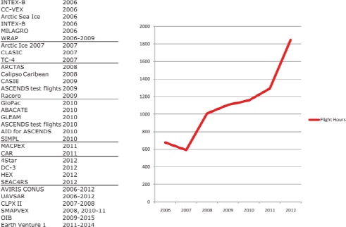
FIGURE 2.2 Airborne Science Program flight hours in support of decadal survey missions, 2006-2011. SOURCE: Courtesy of NASA.
Hawk science mission in 2010 was a joint NOAA/NASA project measuring gases and aerosols in the upper troposphere and lower stratosphere and included satellite validation; the second was a NASA mission that focused on hurricane development; and the next NOAA mission targeted observations designed to improve operational weather forecasts and evaluated an automated dropsonde system. The Global Hawk will be used in two upcoming Earth Venture missions—the Airborne Tropical Tropopause Experiment and the Hurricane and Severe Storm Sentinel.
Suborbital missions are also used as a testbed for future spaceborne technology to obtain complementary data that are not amenable to spaceborne observation, for validation of satellite instruments, and for scientific process studies. A unique suborbital program is IceBridge, with regular campaigns in the Arctic and Antarctic to span the gap between the demise of ICESat and the launch of ICESat-2 and provide calibration/validation for those missions (Box 2.4). Suborbital missions cannot, however, be used as a substitute for the many spaceborne missions that require global coverage.
ESD has used airborne platforms for development of instruments for survey missions, at the same time providing science and application results. For example, the Uninhabited Aerial Vehicle Synthetic Aperture Radar (UAVSAR),37 a reconfigurable, polarimetric L-band synthetic aperture radar (SAR), was developed in support of the DESDynI mission. The UAVSAR observed ground deformation that provided new constraints on fault rupture and stress redistribution following the earthquake in Baja California in April 2010. The UAVSAR also imaged the coastline from Florida to Texas after the 2011 Gulf of Mexico oil spill, as well as collecting data over the open ocean.
The DISCOVER-AQ (Deriving Information on Surface conditions from Column and Vertically Resolved Observations Relevant to Air Quality) campaign in July 2011 is another example of NASA’s successful use of airborne platforms. The DISCOVER-AQ campaign used NASA’s P-3B and UC 12 aircraft equipped with in situ and remote sensors to make observations of atmospheric composition between Baltimore, Maryland, and Washington, D.C., in July 2011. The goal of this Earth Venture airborne program is to improve interpretation of satellite observations, which have low vertical resolution or are total-column measurements, so that they can be used to observe and characterize surface air quality. Four phases are planned in different polluted regions. The profile data from DISCOVER-AQ are also important for the development of instruments on the GEO-CAPE decadal survey mission, and they provide complementary data not available from space for process studies of air pollution.
Other successful airborne science efforts include the Student Airborne Research Program (a hands-on 6-week summer course in airborne science for undergraduate and graduate students); the Midlatitude Airborne Cirrus Properties Experiment (MAPEX) for investigating cirrus cloud properties and their effect on Earth’s radiation balance); and the Genesis and Rapid Intensification Process (GRIP), which examines the development of tropical storms and their transition to hurricanes.
Finding: The suborbital program, and in particular the Airborne Science Program, is highly synergistic with upcoming Earth science satellite missions and is being well implemented. NASA has fulfilled the recommendation of the decadal survey to enhance the program.
The NASA Earth Science Technology Office (ESTO38) is the office within ESD that has responsibility for promoting the development of technology required to make the decadal survey missions flight ready.39 Technology development is part of a broader category that NASA and the 2010 National Research Council report An Enabling Foundation for NASA’s Space and Earth Science Missions40 consider “mission enabling.” Following release of the 2007 decadal survey, ESTO explicitly tailored its solicitations toward advancing survey priorities and has funded more than 70 new, competitively selected projects that support the survey missions to varying degrees.41 ESTO has made investments in both mission-focused and crosscutting technologies intended to reduce the technical risk associated with implementing the decadal survey-recommended missions (Figure 2.3).
The most recent Research Opportunities in Space and Earth Sciences (ROSES) Advanced Information Systems Technology (AIST) solicitation (August 2011) partners with ESD’s Applied Sciences Program and makes direct mention of the 2007 survey as a primary document that identifies “the relevant missions and programs and supporting technologies for this solicitation….” It also notes that “the Tier 3 decadal survey missions not yet in study phase are also relevant to AIST.”42
Finding: ESTO has organized its proposal solicitations around the 2007 decadal survey and is investing to advance technological readiness across the survey mission queue.
The 2007 decadal survey made specific recommendations with respect to mission-enabling research activities that aim to create new knowledge and develop a technically and scientifically capable workforce. One part of this broader mission-enabling category is research and analysis (R&A) (also see the section above, “Technology Development”). The survey recommended that NASA ensure that its support for R&A continue at a level commensurate with its ongoing and planned missions, with investments being made both along individual mission lines and across the mission portfolio. It further recommended that this investment remain protected from use to cover cost growth in missions.43 The 2010 NRC report An Enabling Foundation for NASA’s Space and Earth Sciences Missions44 identified that ESD allocated about 40 percent of its budget to the broad category of mission-enabling activities, and NASA has reaffirmed the
38Information about ESTO is available at http://esto.nasa.gov/.
39ESTO also interacts with the NASA Research and Analysis program through joint monitoring of research projects funded under programs like REASoN (Research, Education and Applications Solutions Network; see http://earthdata.nasa.gov/our-community/community-data-system-programs/reason-projects) and MEaSUREs (Making Earth Science Data Records for Use in Research Environments; see http://earthdata.nasa.gov/our-community/community-data-system-programs/measures-projects) that are aimed at advancing data management protocols that have implications for new missions.
40National Research Council, An Enabling Foundation for NASA’s Space and Earth Science Missions, The National Academies Press, Washington, D.C., 2010.
41M. Freilich, Director, Earth Science Division, NASA, presentation to the Committee on the Assessment of NASA’s Earth Science Program, April 27, 2011.
42NASA Science Mission Directorate, “Advanced Information Systems Technology,” Research Opportunities in Space and Earth Sciences–2011, NASA Research Announcement, Solicitation NNH11ZDA001N-AIST, released February 18, 2011, available at http://nspires.nasaprs.com/external/, pp. A.41-2 and A.41-3.
43National Research Council, Earth Science and Applications from Space: National Imperatives for the Next Decade and Beyond, 2007, p. 15.
44National Research Council, An Enabling Foundation for NASA’s Space and Earth Science Missions, 2010.
BOX 2.4 ICEBRIDGE: A SUBORBITAL SUCCESS STORY
IceBridge is a 6-year, $90 million airborne effort intended to partially fill the gap between ICESat and ICESat-2, serving in a calibration/validation role to improve the utility of ICESat measurements and link them to CryoSat-2 (Figure 2.4.1). It will provide measurements of surface elevation change over parts of the ice sheets, Arctic glaciers, and sea ice.1 A second objective is to measure properties needed by ice models, such as bed topography, ice thickness, and snow depth. The focus is on areas that are changing rapidly, such as the Arctic and Southern Ocean sea ice, outlet glaciers on the Greenland ice sheet, the Antarctic Peninsula, and southeast Alaska glaciers. Continued monitoring of elevations in the interior regions of ice sheets in Greenland, West Antarctica, and East Antarctica is also a priority. Logging more than 1,600 flight hours and 760,000 flight kilometers, IceBridge has also delivered key measurements that cannot be made by satellite, including ice thickness and surface elevations of the glacier tributaries feeding into the main Pine Island Glacier, Antarctica; the bathymetry of floating ice tongues and their thinning inland; and bedrock topography and ice thickness of fast-moving outlet glaciers in Greenland.
IceBridge measurements support and enhance complementary projects such as the Investigating the Cryospheric Evolution of the Central Antarctic Plate project; mapping the glacier bed and internal ice layers over areas of international ice core drilling projects in Greenland and Antarctica; and calibration for the European Space Agency’s ice-observing satellite, CryoSat-2. IceBridge serves as an example of successful collaborations
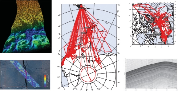
FIGURE 2.4.1 IceBridge provides spatially extensive key measurements in the Arctic and Antarctic in support of Earth science and instrument calibration. Top left: surface altimetry of Crane Glacier, Antarctica; bottom left: Arctic sea ice ellipsoid elevation from the Airborne Topographic Mapper in support of CryoSat-2 calibration; center: IceBridge flight lines over Antarctica; top right: IceBridge flight lines over Greenland; bottom right: snow radar showing internal layers of Pine Island Glacier, Antarctica. SOURCE: Top left: Courtesy of Kyle Krabill and the NASA Airborne Topographic Mapper Team; bottom left: Courtesy of the NASA Airborne Topographic Mapper Project; center and top right: Courtesy of NASA Operation IceBridge; bottom right: Courtesy of the Center for Remote Sensing of Ice Sheets.
involving more than a dozen U.S. universities and international collaborations with scientists from Australia, Canada, Denmark, France, Greenland, and the United Kingdom. All data are freely available within 6 months of acquisition through the National Snow and Ice Data Center.
Among the advantages of suborbital efforts like IceBridge are that varied and multiple instruments can be used onboard airborne laboratories, innovative instruments can be tested, and flight patterns can be optimized for specific tasks. However, suborbital platforms can provide observations only at regional scales. In this respect, IceBridge is an ideal example, as it was able to focus on especially sensitive portions of ice sheets and glaciers as its domain. Even in this context, however, it must leave unobserved large portions of the major ice sheets and sea ice, which ICESat-2 will regularly monitor over several years.
1The IceBridge instrument suite currently consists of three lidar systems (Airborne Topographic Mapper, Laser Vegetation Imaging Sensor, and Sigma Space Photon Counting Lidar Prototype), four radar systems (Multi-channel Coherent Depth Sounder, Snow depth radar, Ku-band radar altimeter, and accumulation radar), gravimeter, and high-resolution aerial photography. Platforms include NASA’s airborne laboratories on the DC-8, P-3B, King Air B-200, the Basler BT-67, a Single Engine Otter, and UAVs, including NASA’s Global Hawk and Ikhana (planned).
accuracy of this allocation for 2011, stating that funding for mission-enabling activities is just under half of ESD’s total budget.45
Although there are specific NASA budget items titled “research and analysis,” the committee was made aware by NASA officials that the level of integration of R&A activities throughout ESD, and the broad definition used for R&A, make it difficult to quantify the total investment in R&A with a specific number. Nevertheless, the committee concluded that the level of R&A and the manner in which R&A is conducted in ESD are commensurate with the recommendation and intent of the 2007 decadal survey. However, with cost growth in missions and with a lower overall budget, there will be continued pressure to reallocate R&A funds to meet mission needs.
The survey noted that assimilation of satellite data into numerical models, and model-based Observing System Simulation Experiments (OSSEs), are other facets of data integration warranting continued investment by NASA. It also recommended that NASA, NOAA, and the USGS should increase their support for Earth system modeling, including provision of high-performance computing facilities and support for scientists working in the areas of modeling and data assimilation.46 Although significant progress has been made in the area of data assimilation for weather forecasts, much work remains to verify integrated Earth systems models. In particular, Earth observations have to be assimilated into such models to create a consistent and integrated picture of the Earth system, and these observations have to be integrated into a predictive modeling system that can make reliable forecasts far into the future.47
45M. Freilich, Director, Earth Science Division, NASA, presentation to the Committee on the Assessment of NASA’s Earth Science Program, April 27, 2011.
46National Research Council, Earth Science and Applications from Space: National Imperatives for the Next Decade and Beyond, 2007, p. 15.
47The 2007 decadal survey also discusses the need for data to be acquired and archived in a way that supports future reprocessing, noting its particular importance for the development of climate data records. As stated by the decadal survey’s Panel on Climate Variability and Change: “Reprocessing of data allows the incorporation of gains in knowledge, the correction of errors in preflight and in-flight calibrations, inclusion of changes in instrument function, and the correction of errors in earlier processing algorithms” (National Research Council, Earth Science and Applications from Space: National Imperatives for the Next Decade and Beyond, 2007, p. 264). For a more detailed discussion of reprocessing and its role in a climate observing system, see K. Trenberth, “The important

FIGURE 2.3 Investments made by the Earth Science Technology Office in technologies for decadal survey missions. Investments are divided into four categories: instrument technology investments, component technology investments, information systems investments-direct applicability, and information systems investments-secondary applicability. Component and information systems investments may apply to more than one mission. Each box represents a single investment or test. SOURCE: NASA Earth Science Technology Office.
The committee’s overall assessment is as follows:
Finding: NASA has maintained a healthy investment in R&A activities and has protected the budgets of both mission-specific and non-mission-specific R&A programs against possible reallocation to cover cost growth in mission hardware.
role of continuity of observations and data products for IPCC: Critical role for GCOS and WCRP,” GEOSS Support for IPCC Assessments, A Workshop on the Data Needs of the Climate Impacts, Adaptation and Vulnerability Research Community, February 1-4, 2011, Geneva, Switzerland, meeting documents and presentations available at http://www.earthobservations.org/meet_wss.shtml.


