
The gaps in geospatial intelligence-related knowledge and skills identified in Chapter 5 can be filled through education and training. Training in the disciplines, methods, and technologies underlying geospatial intelligence is offered by a variety of organizations. University undergraduate programs provide the basic knowledge and skills needed by National Geospatial-Intelligence Agency (NGA) scientists and analysts. More specialized training is available through university graduate programs, professional development programs sponsored by government agencies and private companies, and workshops and short courses offered by professional and scientific societies. This chapter describes education and training programs relevant to geospatial intelligence offered by these diverse organizations (Task 3). Few of these programs were designed specifically for NGA’s employment needs and, thus, do not offer all of the knowledge and skills needed by the agency (e.g., mathematics, statistics).
The knowledge, skills, and techniques used to produce geospatial intelligence are diverse, so the list of relevant education and training programs is long. Consequently, the committee chose a set of representative examples in universities, government agencies, professional societies, and industry that meet a range of geospatial intelligence needs. Examples were chosen based on two or more of the following criteria:
• a long record of accomplishment in producing graduates with relevant knowledge and skills;
• a critical mass of high-caliber instructors;
• a significant number of students receive training; and
• an opportunity to solve problems in a real world context.
Universities provide students with a strong foundation in state-of-the-art geospatial science and technology as well as a means to augment skills with specialized training in a particular subject. Some universities also provide other types of skills and experience useful for producing geospatial intelligence, such as the ability to think and work across discipline boundaries, to combine scientific knowledge with practical workforce skills, or to apply scientific knowledge to solve real-world problems. Examples are described below.
Undergraduate Degree
Undergraduate degree programs are the primary supplier of geospatial skills, concepts, and knowledge for most geospatial analysts. The Department of Geography at the University of Colorado, Boulder, offers a typical undergraduate curriculum that teaches geospatial knowledge and skills. The department offers three primary emphases in geographic information science: Geographic Information Systems (GIS), remote sensing, and cartographic visualization. The GIS track focuses on spatial data structures and algorithms and on the application of GIS for modeling physical and human systems. The remote sensing track emphasizes
image processing for environmental modeling and monitoring. The cartographic visualization track emphasizes geographic information design and Internet and World Wide Web spatial data applications.
The University of Colorado undergraduate major in geography with a concentration in geographic information science requires 45 credits. The flow of geography courses is shown in Figure 6.1 and descriptions of the courses are given in Table A.11 in Appendix A. The term “required” indicates which courses satisfy prerequisites in the flow. For example, GEOG 3023 (Statistics for Earth Sciences) is prerequisite to GEOG 4103 (Introduction to GIS) and GEOG 4203 (Advanced Quantitative Methods). Core skills covered in these classes include the understanding of maps, scale, geodesy and map projections, cartographic transformations, georectification, and coordinate systems. More advanced classes cover map analysis, image analysis and interpretation, the representation of geographical objects and fields, spatial modeling, and statistics. The classes require students to download, merge, and process imagery and map data, and to create new versions and interpretations to suit a particular goal.
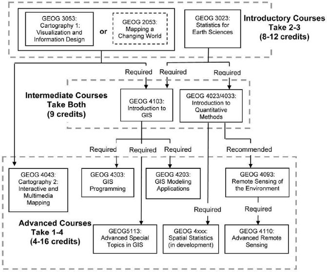
FIGURE 6.1 Course of study at the University of Colorado, Boulder, for an undergraduate degree in geography with a concentration in geographic information science. GEOG 2053 (dashed box) is optional.
Some universities offer graduate programs designed especially for federal workers and contractors. For example, the master’s of science program at George Mason University is tailored to military or government contractors and emphasizes training to solve real-world problems. George Mason University is located near a cluster of federal employers in the Washington, D.C., region, which is attractive to workers seeking part-time graduate training while remaining employed. Moreover, many instructors come from the federal government, which facilitates communication between an academic training center and government employers.
The George Mason University master’s in geographic and cartographic sciences focuses on preparing students for careers in geography, remote sensing, and GIS, as well as cartography, visualization, and modeling.1 Courses concentrate on the techniques of compilation, display, and analysis of spatial data, and on associated applications (see Table A.12, Appendix A). In addition to a core curriculum consisting of coursework in GIS, remote sensing, and quantitative methods, students may take up to 24 credits of elective coursework. Electives focus on environmental applications, such as land use or hydrographic applications; on cultural and human systems, such as transportation, food security, and medical applications (e.g., GIS applications to model disease vectors); or on strategic applications, such as the geography of insurgency. In-depth training in cartography, spatial database management, and programming is also offered.
Professional Science Master’s Program. Many employers are looking for individuals who possess scientific expertise along with practical workforce skills in communication, management, legal and regulatory affairs, and administration. Professional science master’s programs are intended to produce graduates with this mix of scientific and practical skills. Internships are required of students, and an employer advisory board must be involved in program design and evaluation. The degree model was developed from an initiative of the Sloan Foundation in the 1990s, and professional science master’s programs are now coordinated by the Council of Graduate Schools.2
Four universities offer geospatially oriented professional science master’s programs under the Council of Graduate Schools. North Carolina State University offers a professional science master’s degree in Geospatial Information Science and Technology, which is aimed at the development, management, and application of new technology to understand and manage spatial phenomena, such as economic development, disease, emergency planning and response, and environmental resources. Other relevant professional science master’s programs include Applied Geospatial Sciences, Geospatial Technologies Emphasis (Northern Arizona University), Cartography and Geographical Information Systems (Binghamton University), and Geographical Information Systems and Remote Sensing (University of Pittsburgh).
Some master’s programs have similarities to the professional science master’s model, even though they lack the formal designation by the Council of Graduate Schools. For example, several universities offer professional master’s degrees aimed at current practitioners as well as students seeking employment in the geospatial technology industry. Examples include the Pennsylvania State University, University of Minnesota, University of Southern California, Northwest Missouri State University, University of Denver, and the University of Colorado, Denver. Some master’s programs in geography require internships, hire professionals to teach courses as adjunct instructors, and specify applied geography in the degree title or area of concentration.
Distance Learning
The traditional campus-based programs discussed above are not convenient for everyone, including individuals who work full time or who live far from a suitable university. Distance learning programs offer students a path to receiving formal training without requiring physical access to campuses as well as the flexibility to choose the time of day they devote to study. A growing number of universities provide online
__________________
1 See <http://ggs.gmu.edu/AcademicPrograms/MSGECA/MSGECAGuidelines.pdf>.
2 See the program description provided by the National Professional Science Masters Association at <www.npsma.org> and the criteria required for a Professional Science Masters affiliation at <http://www. sciencemasters.com/>.
education and training in geospatial areas. Pennsylvania State University was one of the first to offer such programs and its online GIS curriculum has had time to mature. The Pennsylvania State World Campus offers a number of professional degrees, without the requirement of a thesis, including a master’s in geographic information systems and another in geospatial intelligence.3 Courses are taught by 25 instructors, about half of whom are in residence at Pennsylvania State University. All courses are 10 weeks long and require 8 to 12 hours of student effort per week. The degree requires 35 credits, including 6 credits at the 400 level and a minimum of 12 additional credits at the 500 level or above (see course descriptions in Table A.13, Appendix A). Graduate-level courses in technical writing or project management may be counted toward the degree as electives. Topics covered include geodatabase design, spatial analysis, project management, and geospatial data analysis.
An interesting advance in distance learning is Massive Open Online Courses (MOOCs), which provide free online courses to anyone interested. Some MOOCs have attracted more than 100,000 students (Lewin, 2012). MOOCs have the potential to reach students who might not otherwise learn about geospatial science or technology. However, they have yet to be proven effective (e.g., Fini, 2009), and the specialized topics of interest to NGA may not attract the large numbers of students targeted by MOOCs.
Certificates
Certificate programs are a popular training option for students or professionals who want to augment their skills without obtaining another degree. Certificates acknowledge special training in selected subject matter, and they are commonly awarded as part of a bachelor’s, master’s, or doctorate degree. Obtaining a certificate does not mean that a person is legally “registered” in a profession. Registration usually requires the applicant to pass a rigorous standardized test administered by state-legislated authorities.
A substantial number of institutions grant certificates in cartography, GIS, and remote sensing (see Table A.14, Appendix A). There are no universal standards associated with geographic information science certificates. Rather, each institution determines the course content and number of credit hours required to complete the certificate. Most geographic information science certificates are awarded for advanced theoretical and technical training. For example, the University of Texas, Dallas, offers two 15-hour graduate certificates in remote sensing: one focused on remote sensing and digital image processing and the other focused on the application of geospatial ideas and techniques to national security and intelligence. The National Center for Remote Sensing, Air, and Space Law at the University of Mississippi offers a 12-hour certificate in remote sensing, air, and space law.4Table A.15 (Appendix A) summarizes the course requirements for a certificate in GIS with an emphasis in remote sensing at the University of Utah.
A few certificates are awarded for taking a single course, independent of a formal academic degree. For example, the University of Twente International Institute for Geo-Information Science and Earth Observation offers certificates in a variety of geospatial topics, including remote sensing, hyperspectral remote sensing, remote sensing and digital image processing, cartography and geovisualization, and principles of GIS.5
Interdisciplinary Programs
Although there is an enduring need for deep expertise in the various scientific disciplines, demand is growing for graduates who can think and work across disciplinary boundaries to solve large and complex problems of importance to science and society (NRC, 1994, 1995; Nerad and Cerny, 1999; Nyquist et al., 1999; Nyquist, 2000; Golde and Dore, 2001; Pallas, 2001; Lélé and Norgaard, 2004). An interdisciplinary perspective can be helpful for dealing with a variety of geospatial intelligence issues, such as those that concern coupled human-environmental systems (e.g., the national security implications of climate change, economic globalization, poverty, and transborder migration). Interdisciplinary programs commonly begin at the initiative of faculty, although a few agency programs are available to support their development.
__________________
3 See <http://www.worldcampus.psu.edu/MasterinGIS.shtml>.
4 See <http://www.spacelaw.olemiss.edu/academics/certificate.html>.
Integrative Graduate Education and Research Traineeship (IGERT) Program. The National Science Foundation (NSF) established the IGERT program to produce Ph.D. scientists and engineers with interdisciplinary training, discipline knowledge, and technical, professional, and personal skills (e.g., communication, ethics, teamwork, leadership) that are useful to both academic and nonacademic careers.6 IGERT grants are awarded competitively to university faculty, and projects can be funded for as long as 10 years. The projects are organized around an interdisciplinary science theme but include opportunities for hands-on experience, work in other countries, and professional development (e.g., internships) that complement academic preparation.
A number of IGERTs have touched on the core or emerging areas discussed in this report. For example, the Sensor Science, Engineering, and Informatics project at the University of Maine is examining all aspects of sensor systems, from the science and engineering of new materials to the interpretation of sensor data. The objective is to use knowledge from sensorgenerated data to drive development of sensor systems and advances in sensor materials and devices, and vice versa. A recent IGERT with an explicit geospatial focus was the Integrative Geographic Information Science Traineeship project at the State University of New York, Buffalo. The project facilitated interdisciplinary research in geographic information science, environmental science (e.g., integration of spatial databases with regional models to forecast environmental changes), and social science (e.g., integration of spatial analysis and spatial statistics with GIS to detect crime or disease hot spots). As part of the project, the IGERT team provided a rapid, large-scale damage assessment following the 2010 Haiti earthquake.7
A 2006 assessment found that the IGERT program has had a measurable impact on students, faculty, and institutions (Carney et al., 2006). Students in IGERT programs reported feeling well grounded in their discipline but better prepared to work in multidisciplinary teams and to communicate with people in other disciplines compared to their non-IGERT peers. In addition, IGERT faculty increased their interdisciplinary work, leading to new collaborations, research ideas, and courses, and, in some cases, to stronger institutional support for interdisciplinary approaches. For example, some IGERTs have become self-sustaining Ph.D. programs after NSF support ended (Box 6.1).
University of Southern California (USC) Joint Games Program. Games have moved beyond simple entertainment to become tools that support a variety of applications, including military recruitment and training (e.g., America’s Army game;8 NRC, 1997) and training in human geography. For example, “Sudan: Darfur is Dying” is a narrative video game that simulates the experience of 2.5 million refugees in the Darfur region (Figure 6.2). Players deal with threats to the survival of their refugee camp, such as possible attack by Janjaweed militias. They can also learn more about the genocide, human rights, and the humanitarian crisis in Darfur.
Games are inherently multidisciplinary, requiring designers, engineers, and artists to come together to design the gameplay and visuals and to program the software. Games programs at universities also have an interdisciplinary element. A good example is the USC joint Games Program, which was created by Michael Zyda, a member of this committee. The Department of Computer Science at USC offers a bachelor’s program in computer science (games) and a master’s program in computer science (game development; Zyda, 2009). The master’s program requires computer science students to take three game design courses in the School of Cinematic Arts, which are aimed at getting designers and engineers used to working together and learning each other’s strengths.
Students interested in joint game building spend their last year building games in large teams of designers, computer scientists, and artists from a wide range of departments (Figure 6.3). The joint Games Program 491 course begins in the spring with a call for game designs. A panel of industry and faculty members chooses which designs will be developed, and the leads for the game designs chosen flesh out their game design and recruit their teams by the first day of fall classes. During the fall semester, the teams develop a playable prototype. In the spring semester, midcourse corrections are made
__________________
6 See <http://www.nsf.gov/publications/pub_summ.jsp?WT.z_pims_id=12759&ods_key=nsf11533>.
7 See <www.igert.org>.
8 The America’s Army game, initially built to support Army recruiting, now has more than 13 million registered players and has become the core platform behind many Army training systems. See <http://info.americasarmy.com>.
BOX 6.1
From an IGERT Project to an Interdisciplinary Ph.D. Program
In 1999, Kathleen Carley, committee member and professor at Carnegie Mellon University, received an IGERT award to study social complexity and change using computational analysis of social and organizational data. The primary methods used in the project were network analysis, agent-based modeling, and statistical models of dynamic systems, and students took courses in network analysis, computer simulation, statistics, algorithms or machine learning, and organization or policy science. Students could come from any department in the university, and the course of study was overseen by advisors from the home department, a computer science department, and a social science department Over the 1 0-year lifespan of the project, 18 students received some support from the program and 10 others became affiliates.
Shortly after the IGERT project began, several other educational initiatives that blended computer science and social, organizational, or policy science were started at Carnegie Mellon University. Because these programs were spread over many departments and colleges, mentoring the growing number of students became increasingly difficult. By 2001, several faculty with interdisciplinary interests in computer science and the social and organizational sciences had moved their appointments to the Institute for Software Research, a new department in the College of Computer Science. These faculty banded together to form the Computation and Organization Science (COS) Ph.D. program, which became a standing program in 2004.
The COS curriculum was designed after the IGERT curriculum, but was expanded to include a policy component. The COS program is aimed at producing new Ph.D.s capable of (1) assessing the social or policy impact of new computational technologies, such as crowdsourcing technologies for disaster response; and (2) designing, developing, and testing new computational technologies that will affect humans at the societal, cultural, or policy level, such as new cell-phone applications that track and share the movements of individuals. Students are taught the basics of social network analysis and the advanced methods integral to dynamic network analysis, and the program of study is tailored through electives that can be taken in any of the colleges at Carnegie Mellon University Special attention is placed on geo-enab led network analytics Where the goal is to track the reg ion of influence of actors of interest or to identify how to disrupt terror or piracy networks in a region, the combination of social and spatial information and the use of unified tools is criticaL Through a combination of project-based courses and research, the students acquire knowledge, skills, and practical experience needed to contribute to advances in these areas.
Today the COS program has 27 Ph.D. students and 18 alumni who are employed in both industry and academia. Students trained in networks, and in particular those with a strong computational or geo-network background, are in high demand. However, the number of qualified students applying to conduct research in this area far exceeds the available fellowships, research grants, and industry support for master’s programs.
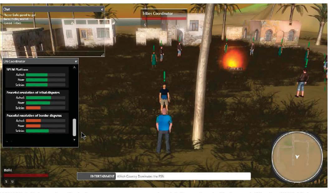
FIGURE 6.2 Screenshot of a Sudan game intervention: spreading beliefs to reduce levels of intertribal hostility. SOURCE: Courtesy of the USC GamePipe Laboratory.
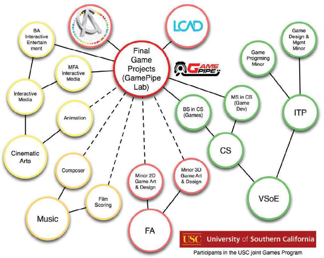
FIGURE 6.3 Participants in the joint USC Games Program, including several USC departments, Atlantic College (Puerto Rico), and the Laguna College of Art and Design (LCAD) Game Art Program. The solid lines indicate strong participation; dashed lines indicate some participation. NOTE: CS = Computer Science Department; FA = Fine Arts Program; ITP = Institute of Creative Technologies; VSoE = Viterbi School of Engineering.
and the teams continue developing their games. At the end of the semester, each team demonstrates a polished product with 2–4 hours of gameplay to fellow students and industry executives.
Building the USC joint Games Program required time, effort, and courage. The question of how and when to support a new area is difficult for most universities. Moreover, the university department structure works against multi- and interdisciplinary programs, and issues about where to establish the departmental home, where to manage the budget, how to evaluate the faculty, and how to obtain enough space had to be resolved. However, once established, the program has proven a success. The joint Games Program was rated the top game design program by the Princeton Review in March 2011,9 and it is not unusual for the student teams to be recruited by the gaming industry.
Summer Programs
Advanced techniques and methods are commonly taught in university summer courses. The largest U.S. summer program in GIS and spatial analysis is offered by the Interuniversity Consortium for Political and Social Research (ICPSR), which is based at the University
__________________
9 See <http://www.hollywoodreporter.com/news/usc-named-top-school-video-162975>.
of Michigan. ICPSR offers 5-day workshops dealing with introductory spatial regression analysis and spatial econometrics. Its counterpart in the United Kingdom is the University of Essex Summer School in Social Science Data Analysis, which offers a 2-week intensive course on spatial econometrics. The Spatial Econometrics Association runs a 4-week Spatial Econometrics Advanced Institute every summer in Rome.
Summer courses in network analysis are offered by ICPSR and Carnegie Mellon University’s Center for Computational Analysis of Social and Organizational Systems (CASOS) and COS Ph.D. program. The CASOS summer institute provides continual reeducation on geo-enabled network analysis and dynamical analysis. Courses focus on new tools for analyzing network data, which are evolving rapidly; changes in technologies for data collection, visualization, and forecasting that influence the analysis of network data; and advanced analyses that have a spatial, temporal, or large-scale data component. All COS Ph.D. students have the opportunity to take this program and teach in it, and the new advances that they develop are presented as part of an associated symposium.
Government training programs are established to meet the specialized needs of federal agencies. Military colleges offer an opportunity to train students in relevant disciplines and techniques within the context of national security and defense. Training programs offered by federal agencies provide a means for employees to update or augment necessary skills. Such training is important for geospatial intelligence, given the rapid advances in geospatial technologies and the need for operational knowledge, experience, and tactics, which cannot be fully taught in academic settings.
NGA Vector Study Program
The Vector Study Program, originally called the Long Term Full Time Training (LTFTT) program, was established more than 50 years ago to enable civilian employees of NGA’s predecessor organizations to obtain university training in selected areas while receiving full salary and benefits. NGA identifies critical skills needed, interested employees apply for specific programs, and universities accept applicants through the normal selection process. The program pays for tuition and all course-related expenses for classes in bachelor’s, master’s, and doctorate programs. The master’s program is funded for 1 year (three semesters) and the doctorate program is funded for 2 years (six semesters). Obtaining a degree is not required, and indeed most advanced degrees can barely be completed within these time periods.
About 70 universities and colleges currently participate in the Vector Study Program. One of the longest running programs is the graduate program in photogrammetry at Purdue University, which was established in the mid-1960s primarily to train employees of federal agencies, including the Defense Mapping Agency, a predecessor of NGA. The program offers master’s degrees, both thesis (research oriented) and nonthesis options, and doctorate degrees. Most trainees elected the master’s nonthesis option, which offers a large number of courses (10–12). The few who chose the thesis option usually worked on topics related to their agency’s activities, seeking solutions to problems encountered in production. Ph.D. trainees commonly worked on state-of-the-art problems of interest to their agency.
Topics covered in Purdue’s graduate program include the fundamentals of photogrammetry, sensor (passive, active, motion-imagery) modeling, platforms (space, airborne, unmanned), lidar, information extraction (targeting, image products such as ortho-imagery, digital elevation models, map features), and photogrammetric data as input to Computer Aided Design, GIS, and virtual reality databases. Other allied courses in the program include analytical fundamentals for geomatics, adjustment of geospatial observations, coordinate systems and conformal mapping, advanced geospatial estimation, modeling, and exploitation of multi- and hyperspectral remote sensing systems. Students who stay beyond the first year enroll in courses in related areas, such as orbit mechanics (for integration into photogrammetric modeling) and digital image processing and analysis (learning the approaches to image feature correspondence). They delve deeply into advanced photogrammetric problems, such as image registration (image to image and image to reference
data) and the complex task of image and data fusion. Additional courses include GIS, remote sensing, geodesy, statistics, navigation, radar, numerical analysis, and databases.
The nonthesis master’s degree at Purdue has trained hundreds of employees of NGA and its precursor agencies in its 50 years of existence. In addition, several individuals received doctorates and went on to become technical leaders within the agency.
NOAA National Weather Service
The National Weather Service (NWS) issues weather forecasts and warnings for the protection of life and property. Weather forecasters fuse results from dynamic model projections, weather images from radars or satellites, ground observations, spotter reports, and their own understanding of storm evolution and atmospheric dynamics to determine the timing, duration, and spatial extent of the warning. The need to discern actionable weather intelligence under tight time pressure mimics what is needed for geospatial intelligence. Moreover, weather information and technologies are innately geospatial, and the skills needed to prepare a weather forecast and issue a warning (e.g., information synthesis, situation awareness) are similar to those needed by NGA scientists and analysts. Thus, NWS training may be a useful model for NGA training, particularly in the areas of forecasts, GEOINT fusion, and geospatial analysis.
The NWS operates three training facilities, including the Warning Decision Training Branch in Norman, Oklahoma. The warning decision facility provides in-residence training workshops and distance learning modules on weather radar operations, particularly the integrated data environment, warning methodology, situation awareness, and decision making.10 In the advanced warning operation course, students are taught the theoretical underpinning of situation awareness, then are given exercises, developed from past weather events, to simulate severe weather operations. These exercises allow students to practice advanced warning concepts in an operational context under different severe weather scenarios. The curriculum is adjusted each year to respond to changing NWS strategic goals and operational requirements and to incorporate the results of evaluations of previous training (NWS, 2008).
Military Colleges
Some U.S. military colleges and universities offer classes or degrees in geospatial topics, often in the context of intelligence or national defense. The U.S. Military Academy offers a bachelor’s degree in geography and environmental engineering, with courses related to environmental geography, human geography, cartography, and geographic information science. The U.S. Air Force Academy offers a bachelor’s degree in geography, with courses in remote sensing, political geography, human geography, cartography, and spatial analysis. The other academies provide some geospatial training within other programs (e.g., ocean science, strategic intelligence and homeland security). At the graduate level, both the Naval Postgraduate School and the Air Force Institute of Technology offer geography courses and courses that use GIS and human geography technologies, although neither has a degree program in this area. Because students generally go into service following graduation, their formal training can be outdated by the time they enter the workforce. However, their experience within the services commonly refines and updates their applied geospatial skills.
PROFESSIONAL SOCIETIES AND NONGOVERNMENTAL ORGANIZATIONS
Short courses and conference workshops offered by professional societies (e.g., Table 6.1) and other nongovernmental organizations provide immersive, short-term training on a variety of geospatial topics of potential interest to NGA. For example, the Association of American Geographers (AAG) hosts workshops on software applications for geospatial analysis. Geospatial technology workshops are led by credentialed experts and typically run a half or full day as part of the annual conference program. The American Society for Photogrammetry and Remote Sensing (ASPRS) offers numerous remote sensing workshops and webinars each year. The workshops and webinars in 2011, for example, focused on hyperspectral and lidar instruments and on accuracy assessment. Some of these
__________________
TABLE 6.1 Major Professional Societies Offering Training in Core or Emerging Areas
| NProfessional Society | Mission | Subject Areas |
| American Geophysical Union (AGU) <http://www.agu.org/> | Promote discovery in Earth and space science for the benefit of humanity | Geodesy, geophysics, remote sensing |
| American Planning Association <http://www.planning.org/> | Advocate excellence in community planning, promote education, and provide tools and support to meet the challenges of growth and change | Human geography |
| Association of American Geographers (AAG) <www.aag.org> | Advocate the understanding of the world’s geography, including human and physical systems and the use of geographic techniques | Cartography, GIS and geospatial analysis, human geography, remote sensing |
| American Society for Photogrammetry and Remote Sensing (ASPRS) <http://www.asprs.org/> | Promote the ethical application of active and passive sensors, photogrammetry, remote sensing, and geospatial technologies; and advance the understanding of geospatial and related sciences | Cartography, GIS, photogrammetry, remote sensing |
| Association for Computing Machinery Special Interest Group (ACM SIG) spatial <www.sigspatial.org/> | Address issues related to the acquisition, management, and processing of spatially related information | Cartography, GIS, remote sensing |
| Cartography and Geographic Information Society (CaGIS) <http://cartogis.org/> | Connect professionals who work in cartography and geographic information science, both nationally and internationally | Cartography, GIS, photogrammetry, remote sensing |
| IEEE Geoscience and Remote Sensing Society (GRSS) <http://www.grss-ieee.org/> | Advance science and technology in geoscience, remote sensing and related fields | Geodesy, photogrammetry, remote sensing |
| Institute of Navigation (ION) <http://ion.org/> | Advance the art and science of positioning, navigation, and timing | Geodesy, remote sensing, cartography |
| International Society for Photogrammetry and Remote Sensing (ISPRS) <http://www.isprs.org/> | A society of national societies and organizations specializing in photogrammetry and remote sensing | Photogrammetry, remote sensing |
| Society of Photographic Instrumentation Engineers (SPIE) <http://spie.org/> | Advance light-based technologies | Geodesy, photogrammetry, remote sensing |
| University Consortium for Geographic Information Science (UCGIS) <http://www.ucgis.org> | Serve as a voice for the geographic information science research community, foster multidisciplinary research and education, and promote the use of geographic information science and geographic analysis for the benefit of society | Cartography, GIS, remote sensing |
| Urban and Regional Information Systems Society (URISA) <http://urisa.org/> | Use GIS and other information technologies to solve challenges in state, regional, and local government agencies | Cartography, GIS, human geography, remote sensing |
workshops and webinars provide opportunities for participants to obtain formal continuing education credit needed for employment, certification, or recertification.
A number of conferences include short courses ranging from several hours to several days focusing on particular software programs, advanced methods in GIS or geospatial analysis, or other specialized topics. For example, the Cartography and Geographic Information Society (CaGIS) offers cartography and GIS-related short courses, such as the 1-week course on spatial statistics with open-source software offered during the GeoStat 2011 Conference. The Institute of Navigation (ION) offers geodesy-related short courses for professional development in positioning, navigation, and timing. For example, the 2011 ION annual GNSS international technical meeting included 16 courses on GPS/GNSS from beginner to advanced levels. Short training courses on social networks are held regularly at the main International Network for Social Network Analysis meeting and sometimes at meetings of the
Academy of Management, the American Sociological Association, and the Institute for Operations Research and the Management Sciences. These training sessions have helped spread new capabilities and also contributed to growth in the field.
Several companies provide training in using the tools they have developed, some of which are being used by NGA. Among the most notable is the Environmental Research Systems Institute (ESRI), a company specializing in GIS software and geodatabase management applications. ESRI hosts an annual user’s conference, which is a forum for training individuals to use ESRI products. Courses, which are either taught by instructors or are self-paced, focus on GIS technology skills and practices to accomplish GIS workflows on the desktop, server, and mobile web.11 BAE Systems offers courses on its photogrammetric products and workstations with SOCET GXP software in several cities.12 Intergraph Corp. teaches 1- to 4-day classes in geospatial technology, video systems, and its geomedia software on request in Madison, Alabama.13 In addition, some manufacturers of GPS/GNSS receivers offer training courses to their customers. Navtech GPS currently offers 12 courses, some of which deal with the geodetic aspects of GPS/GNSS, at both public venue and corporate facilities.14 Most of these courses are based on proprietary systems, although training based on open-source software and tools is beginning to emerge (e.g., open-source GIS boot camp offered by Geospatial Training Services LLC).15
The third task of the committee was to describe training programs for geospatial intelligence disciplines and analytical skills. Training programs relevant to geospatial intelligence abound in universities, government agencies, professional societies, and industry. Universities provide the widest variety of training programs, ranging from comprehensive degree programs that cater to individuals preparing for a career in geospatial science or technology to specialized programs and certificates aimed at expanding or updating the knowledge and skills of professionals. Although a few universities offer degrees in interdisciplinary fields, such as those related to the emerging areas, such programs remain difficult to create and sustain. Training offered by government agencies, professional societies, and private companies focuses on education and professional development of individuals already in the workforce and generally takes the form of workshops, short courses, or classes on particular tools or techniques. Distance learning is increasingly an option for all types of training.
The training programs chosen to address Task 3 have a long record of accomplishment, a critical mass of high-caliber instructors, a substantial number of students, and/or provide an opportunity to solve problems in a real-world context. The example programs and their relevance to NGA are as follows:
• A typical undergraduate curriculum, which provides a foundation of geospatial knowledge and skills (e.g., University of Colorado’s Department of Geography).
• Master’s of science programs, which emphasize solutions to real-world problems (e.g., George Mason University’s master’s program in geographic and cartographic sciences).
• Professional science master’s program aimed at producing graduates with a mix of scientific expertise and practical workforce skills (e.g., North Carolina State University’s professional science master’s program in geospatial information science and technology).
• Degrees or classes in geospatial topics in the context of intelligence or national defense (e.g., military colleges).
• Interdisciplinary programs, which are useful for dealing with complex geospatial intelligence issues (e.g., Carnegie Mellon University’s Computational and Organization Science program; University of Southern California’s Joint Games Program).
__________________
11 See <http://www.esri.com>.
12 See <http://www.socetgxp.com/content/events/trainingcourses>.
13 See <http://www.erdas.com/service/training/training.aspx>.
14 See <www.navtechgps.com>.
15 See <http://www.geospatialtraining.com/index.php?option=com_catalog&view=node&id=71%3Aopen-source-gis-bootcamp&Itemid=108>.
• A mature distance learning program (e.g., Pennsylvania State University’s GIS curriculum).
• Certificates acknowledging special trammg in selected subject matter (e.g., University of Utah graduate certificate in GIS with an emphasis in remote sensing).
• Summer programs, short courses, and workshops aimed at teaching advanced techniques and methods (e.g., Interuniversity Consortium for Political and Social Research’s summer program in GIS and spatial analysis; ION’s short courses in positioning, navigation, and timing; ESRI’s annual user’s conference, with short courses on GIS technology and skills).
• Programs that send employees for training at universities while receiving full salary and benefits (e.g., NGA’s Vector Study Program).
• Operational training in issuing forecasts and warnings (e.g., National Weather Service’s Warning Decision Training Branch).


