
5
Mass Wasting and Flooding
A. S. Nieto, Department of Geology, University of Illinois, Urbana
R. L. Schuster, U.S. Geological Survey, Denver, Colorado
G. Plaza-Nieto, Escuela Politécnica Nacional, Quito, Ecuador
INTRODUCTION
This chapter deals with slumps and slides, debris avalanches, debris flows, and flooding, the processes that account for the largest amount of destruction and number of deaths induced by the March 5, 1987, earthquakes.
LANDSLIDES
Landslide processes are described first, then interpreted in light of the field observations. The descriptions are grouped into three field traverse areas (from W to E) that are progressively closer to the epicenters of the earthquakes, located about 25 km NNW of Reventador Volcano: Quito-Baeza, Baeza-Salado, and Reventador Volcano (Figure 5.1). Field observations for the first two areas were made mostly by land along the Trans-Ecuadorian highway from Quito to the mouth of the Salado River; the observations in the Reventador area were made by car, helicopter, and airplane.
Quito-Baeza
This traverse is divided into three approximately equal parts, each about 25 km long. Midpoints of each of these sections are 90 km, 80 km, and 75 km from the epicenters. The first section is the eastern half of the Inter-Andean Valley, where Quito is located. This depression is filled mostly with pyroclastic materials—primarily “cangahua”—and glacial till (see Chapter 2). Elevations along this section range from 3,000 to 3,500 m, and the climate is temperate. Slopes are relatively gentle, generally not exceeding 20 to 25°. A few slope failures caused by the March 5 earthquakes were
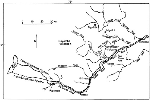
FIGURE 5.1 Map of area E of Quito showing locations of epicenters of the March 5, 1987, earthquakes, the Trans-Ecuadorian pipeline and highway, Reventador and Cayambe volcanoes, and rivers and towns noted in this chapter.
observed in cangahua along very steep to subvertical highway cuts and stream banks. Steep slabs or overhangs failed as falls, topples, and slips. (Mechanical properties and failure mechanisms in the cangahua have been described by Crespo and Stewart [1987]). The types of failures —falls and topples—occurring the farthest from the epicenter confirm observations by Keefer (1984). We also observed fresh slumps and soil flows in sandy morainal deposits at the headwaters of the Papallacta River (Figure 5.1), but ascertaining if these were caused by the March 5 earthquakes is difficult. Further, we observed a couple of examples of old landslide morphology that showed no indication of reactivation.
The next 25 km crosses lava flows that create the divide of the Cordillera Real (Figure 2.1 and Figure 2.2). The lava flows are Quaternary rhyolites, andesites, and basalts. The elevation is about 4,000 m, and the climate is temperate to cold. Relief is high, and soils are nonexistent or colluvial. Slopes are nearly vertical in the lava flows, and moderate—25 to 35°—in talus deposits at the foot of cliffs. Some slopes have columnar joints or stress-relief joints. We observed a few topples, some of which may have been related to the earthquakes, and also a few talus slopes with evidence of some recent movement.
The last 25 km or so to Baeza comprise the descent to the sub-Andean zone (western edge of the Oriente, Figures 2.1). In this stretch, the highway follows the Papallacta River. The rocks are Cambrian and Precambrian gneisses and schists. Elevations range from 3,500 m at the western end to 1,500 m near Baeza. Relief is very pronounced; some slopes are 45° or steeper. Residual soils are thin or absent for most of the section. Only in the lower reaches of the Papallacta River, a few kilometers E of Baeza, did we observe a few debris flows on the highest parts of the Papallacta valley walls. These debris flows were shallow and had the same characteristics as those described in detail in later sections.
Baeza-Salado
This traverse extends from the town of Baeza down the Quijos River, where it joins the Salado River to form the Coca River (Figure 5.1). In general, the denudation around Baeza was only moderate. Some shallow debris flows in residual soils could be seen on the crests of slopes around the town. In addition, a small number of rock slides and rock glides, as well as a few slips and slumps in old and recent alluvial terraces (Figure 5.2), were observed. Landslide intensity increased progressively from El
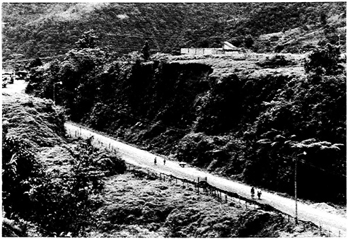
FIGURE 5.2 Thin earth slide (center of photo) on steep face of alluvial terrace on western edge of the town of Baeza.
Chaco to Salado. The pattern of landsliding included initiation points located high on steep slopes covered with shallow residual soil and weathered rock. This pattern, which became apparent in areas closer to the epicentral zone, is discussed in detail below. The most significant observation along this traverse is that very few of the debris flows reached the Quijos River channel. Thus, landslide material contributed little to the sediment load of the Quijos. Some detailed observations along this last portion of our traverse follow:
Young alluvial terraces, 15 to 20 m high near Baeza, have been created by stream degradation (Papallacta River and tributaries). Intense chemical weathering has modified these alluvial deposits, giving them certain characteristics of residual soils. This veneer of residual/alluvial materials commonly was involved in slip/debris-flow failures of the steep terrace slopes. The relatively unweathered alluvial material (probably cemented) underneath this veneer remained unaffected.
From Baeza to about 20 km to the NE, the Quijos River follows the contact between Paleozoic and Mesozoic rocks (Baldock, 1982), probably coincident with a major thrust; the Trans-Ecuadorian highway and pipeline lie on the W (left) side of the Quijos valley (Figure 5.1). For the next 20 km to the confluence of the Quijos and Salado rivers, the highway and pipeline begin to climb over Cretaceous sedimentary and metasedimentary rocks. These lifelines follow high elevations and drainage divides, which, in turn, coincide with hogbacks formed by generally massive quartzose sandstones that occur within the Mesozoic sequence. Note that the residual soil veneer on the steep slope of the hogback is very thin or nonexistent, as is generally the case in this area. Consequently, the earthquake-induced landsliding was also very shallow. Slope failure began as slips at the highest points of the steep slopes; the slip surfaces coincide with the top of weathered rock and the slips moved rapidly downslope, becoming debris flows (Figure 5.3). This type of landsliding endangered the highway and pipeline, but the slips were generally very thin (less than 1 m) and seldom reached the channel of the Quijos (Figure 5.4).
From about 30 km NE of Baeza to the confluence of the Coca and Salado rivers, the highway follows the steep slope of a massive hogback; for most of this distance the highway is closely paralleled by the pipeline. The highway has been located approximately at the contact between the steep upper slope, covered with a very thin veneer of residual soil, and the lower, gentler colluvial slope. Many very shallow rock falls, debris avalanches, and debris flows (Figure 5.5) moved down from above the highway and blocked it. Although these landslides blocked the highway for several kilometers, local volumes of weathered rock and soil were small, and the landslide materials were fairly easily removed by maintenance crews.

FIGURE 5.3 Landslides (largest examples are indicated by arrows) in residual soils at the top of the N valley wall of the Quijos River between El Chaco and the confluence of the Quijos and Salado Rivers. Because slide-resistant sedimentary bedrock (light-colored outcrop at the lower left) is close to the surface, these slides/ avalanches are shallow and generally limited to existing gullies. Although the slides endangered the Trans-Ecuadorian pipeline and highway (angling across top of photo above the landslides), they caused little actual damage because they were so shallow.
Reventador Volcano
Geological Background
This area includes the greatest intensity of landsliding triggered by the March 5 earthquakes. The Reventador Volcano zone, as defined here, is located in the sub-Andean region; it centers on Reventador Volcano and is bounded by the valleys of the Salado River on the W, the Coca River on the SE, the Quequno River on the N, and the Dué River on the NE (Figure 5.1). The zone includes the greatest intensity of landsliding triggered by the March 5 earthquakes. The earthquake epicenters lie a few kilometers to the N and W of the Reventador area; they are not immediately adjacent to the areas of most intense landslide activity.
The zone presents a large amount of relief both as a unit and locally; elevations range from about 1,550 m on the floor of the valley of the Coca
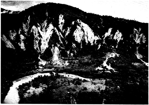
FIGURE 5.4 Landslide activity on the NW (left) valley wall of the Quijos River just upstream (SW) from its confluence with the Salado River. The earthquaketriggered slope failures began as thin slips on the steep (45 to 50°) headwalls of the slopes, and were transformed into debris avalanches and debris flows that cascaded down the gullies onto the low terrace that forms the left bank of the river.
River to 3,560 m at the top of Reventador Volcano. The ridges on the W side of the Salado River rise to 3,600 m, and the ridges on the E reach 3,200 m; the midreaches of the Salado River valley are at an elevation of about 1,600 m. Drainage patterns are radial on the volcano slopes and dendritic or rectangular elsewhere. The rectangular pattern reflects the fracture systems that affect this region.
Reventador Volcano and related volcanic deposits constitute the most notable morphologic feature of the zone (Hall, 1977). This feature is made up of a portion of a large cone—the remains of the collapse of two ancient Reventador stratovolcanoes called Paleo Reventador I and II—that contains a smaller cone, the modern Reventador Volcano. The ancient cone resembles an amphitheater, which opens to the E toward the Coca River.
The overall slopes of the uppermost portions of the ancient cone have angles of about 30 to 35°; the slopes decrease progressively to 10° or less in the lowermost portions. The W and SW slopes of the ancient cone have two important and unique morphologic characteristics. The portion of the volcano between the headwaters of Morales Creek (a tributary of the Malo
River) and the Dué Grande River (Figure 5.1) has a dense parallel drainage pattern; long, closely spaced, parallel gullies have deeply dissected the underlying pyroclastic rocks. These gullies are from 50 to 100 m deep and have gradients that commonly are greater than 35 to 40°. The canyons of Morales Creek, the Dué Grande River, and two unnamed tributaries to the N of the Dué Grande have valley walls that reach heights of more than 200 m and have slope angles greater than 60°. The headwaters of these canyons are cirque-like and present large piping (internal-erosion) cavities in the pyroclastic beds. The valley walls of the Coca River have overall slopes generally between 30 and 40°. The top of the right valley wall, which has been eroded into quartzose sandstone of the Hollin Formation (geologic map, Figure 5.6), is almost vertical in several places. Downstream from San Rafael Falls (Figure 5.1 and Figure 5.7), the Coca River becomes entrenched, and the walls are very steep or vertical. Gullies descending the main valley slopes of the Coca River have gradients of 45 to 60°. The valley walls of the Malo River commonly are steeper than 45°. The main valley walls of the
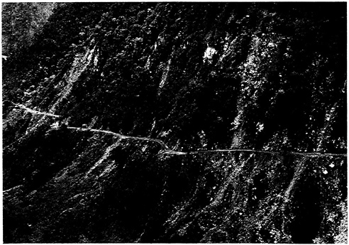
FIGURE 5.5 Landslides along the Trans-Ecuadorian highway 3 km W of its crossing of the Salado River. These rock falls, slides, and avalanches, which were triggered by the March 5, 1987, earthquakes, had blocked the highway almost continuously in the stretch shown in this photograph. The highway was passable at the time of this April 25, 1987, photograph because of the efforts of Corps of Engineers (Ecuadorian Army) highway maintenance crews.
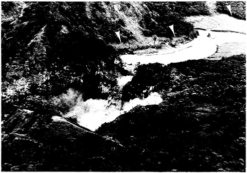
FIGURE 5.7 April 1987 aerial view of San Rafael Falls on the Coca River downstream from Reventador Volcano. Note the vegetation trim line (arrows), which indicates the maximum height of the debris flow/flood, about 20 m above the current level of the Coca River. There is a strong probability that constriction of the river at the falls caused short-lived “hydraulic” damming of the river.
Salado River have overall slopes that usually are between 25 and 35° in their middle reaches. Tributaries of the Salado have variable overall slope angles, about 40° in their midcourses but lower values in their lower courses and uppermost reaches. The valley/gully walls of first- and second-order tributaries of the Salado have slope angles that range from 40 to 60°, or even greater.
The zone has distinct microclimates that vary from cold and dry (annual precipitation of less than 1,500 mm in the highest portions), to temperate in the tributaries of the major rivers, to subtropical (annual precipitation of more than 4,000 mm along the valleys of the lower parts of the Salado, Coca, and Dué rivers). Consequently, the vegetation is a function of elevation. Oaks and some evergreens grow at the highest elevations, shrubs and low trees in the middle elevations, and rain-forest vegetation below 2,500 m.
Rainfall occurs throughout the year, but increases in intensity from March to July. Significantly, anomalously high precipitation occurred in the area in January and particularly in February 1987. On February 3 and 20, the
INECEL gaging station just upstream from San Rafael Falls (Figure 5.1 and Figure 5.7) on the Coca River registered flow rates of 2,600 and 3,400 m3/sec, respectively. These discharges have estimated return periods of 5 and 20 years, respectively. A few days before the earthquake, the flow rates diminished. Thus, the gaging station measured 450 m3/sec at 1700 on March 5; the estimated discharge at 2300 was 600 m3/sec. These values, however, are more than twice the average flow of the Coca River.
Most of the Reventador zone is underlain by subhorizontal and gently dipping sedimentary rocks of Jurassic/Cretaceous and Cretaceous ages (Figure 5.6). The formations mapped in the Reventador zone are from the oldest to the youngest: pyroclastic sedimentary rocks (Misahualli Member of the Chapuzi Formation), quartzitic sandstones (Hollin Formation), shales and limestones (Napo Formation), and red clay shales (Tena Formation). The western boundary of the Reventador zone is composed of Paleozoic gneisses and schists in contact with the sedimentary rocks to the E by major overthrusts. The sedimentary rocks adjacent to the overthrusts have undergone low-grade metamorphism along a belt a few kilometers wide that extends close to the western edge of the Reventador volcanic complex. In the vicinity of Reventador Volcano, the rocks are lavas and pyroclastics, ranging in age from late Pleistocene to Holocene.
Rectangular drainage in some areas and lineaments observable in air-photos provide evidence of strong fracturing. This fracturing affects even the volcanic materials of Holocene age. The most important fracture systems trend N-S and NE-SW. The latter may be responsible for SW-NE course of the Quijos/Coca River.
Away from the flood plains and alluvial terraces of the main rivers and high-order tributaries, the soils are either colluvial or residual. The colluvial soils occur at the foot of the slopes and were generally not involved in the March 5 landsliding. The residual soils range from saprolites to laterites. Because the relief is significant and the area is well drained, the residual mantle is not very thick— from a few centimeters to a few meters at most—and grades rapidly into weathered fractured rock. These soils have very high void ratios and natural water contents; the values of the latter are practically equal to the liquid limits. Under these conditions, these soils have sensitive structures.
General Characteristics of Landslides in the Reventador Zone
More than 90 percent of the observed landslides began as shallow slips or slides of residual soils and highly weathered rock on the uppermost parts of the slopes of the main valleys or on the slopes of the lower-order tributaries (Figure 5.8). Average thicknesses of these slips were from 1.5 to 2.0 m, with a thickness range of a few decimeters to 5 m. The failing masses
FIGURE 5.8 Ridge NW of Reventador Volcano from which jungle vegetation has been stripped by landslides triggered by the earthquakes. The slope failures started as thin slips on the steep (about 50°) upper slopes. As they moved downward, the saturated, vegetation-charged masses were transformed into debris avalanches and then to debris flows that discharged into the Dué Grande River (out of the photo at the bottom). (Photograph by Ken Nyman, Cornell University).
either were transformed into debris avalanches and then into debris flows or, in some cases, were reworked almost immediately into debris flows with high fluidity. Whether they began on a main valley slope or the valley slope of a lower-order stream, flows moved to the channels of the lower-order tributaries and entrained the colluvial/alluvial fills along the channels, eroding the material to the bedrock surface. The debris flows then proceeded to the higher-order tributaries or to the main river valleys. Smaller debris flows stopped lower on the slopes of the main river valleys or in the bottoms of gullies. Debris flows starting higher above the valley floor were also more apt to reach the floodplain than those from lower heights. A large number of the landslide scars displayed unweathered bedrock, attesting to the shallowness of the residual soil mantle.
Overall preearthquake slope angles and gully slope angles on topographic maps at locations of the earthquake-induced slope failures were measured; the locations were determined from postearthquake vertical and oblique airphotos. These measurements indicated that on the left valley wall of the
Coca River, between the Salado pumping station and the Malo River, failures occurred mainly on slopes steeper than 35 to 40°. The same threshold values were obtained for the valley walls of the Salado River and of the Coca River at the confluence of the Salado and Quijos rivers (Figure 5.9A, Figure 5.9B, Figure 5.9C). However, on the upper slopes of the ancient cone of Reventador Volcano at elevations above 3,500 m, we observed failure on slopes between 30 and 35°, involving what appear to be very recent ashes. Other types of landslides (rock avalanches, rock slides along high road cuts, slumps and slides along alluvial terraces, and topples of stress-relief slabs) occurred throughout the entire area, but only sporadically.
Areal Distribution of Landslides and Denudation Intensity
Figure 5.10 shows the approximate limits of areas with different degrees of denudation (expressed as estimated percentage of failed slope area per total area) for the slopes of Reventador Volcano and vicinity. Note the large variation in denudation intensity around the volcano. The degree and characteristics of denudation due to landsliding in nearby valleys are as follows:
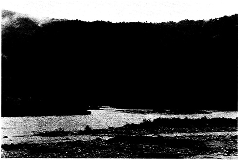
FIGURE 5.9A 1978 view showing the jungle-covered right (SE) valley wall of the Coca River at the confluence (photograph by S. D. Schwarz).
FIGURES 5.9A, B, C Views down the Salado River to the confluence of the Salado and Quijos Rivers to form the Coca River.
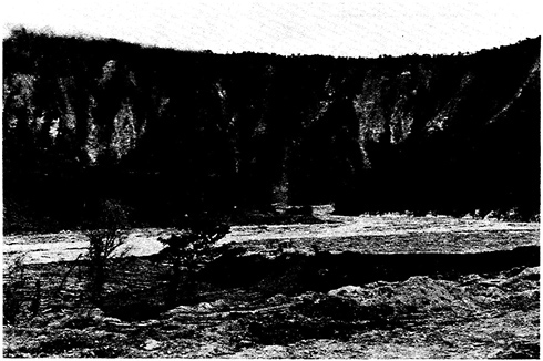
FIGURE 5.9B April 1987 view of the same valley wall showing widespread denudation due to March 5 landsliding.

FIGURE 5.9C June 1990 view of the same valley wall showing partial recovery of vegetation on 1987 landslide scars. Note reconstructed Trans-Ecuadorian highway bridge across the Salado River.
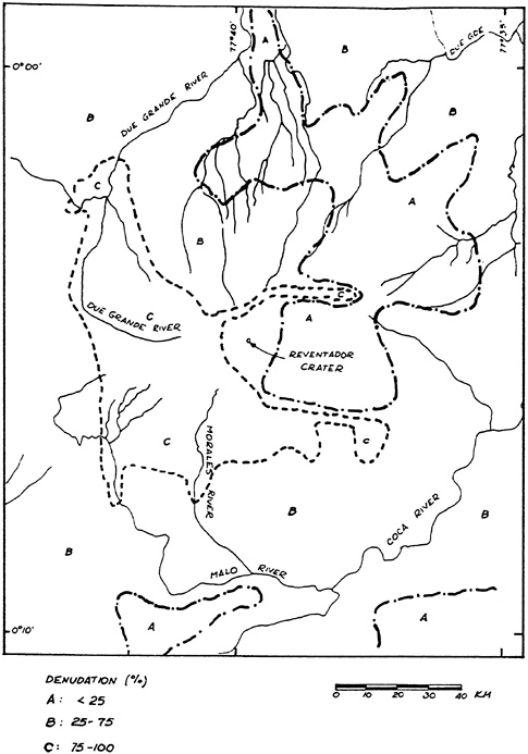
Salado River—variable denudation intensity; range: less than 25 percent to 50 percent; most intense denudation appears to be in first- and second-order gullies of upper reaches of the Salado River, and in third-, fourth-, and lower-order tributaries of lower portions of the Salado River (Figure 5.11).
Quequno, Dué, and Dué Grande rivers—variable denudation; range and local distribution similar to that of the Salado River; however, overall denudation for these areas appears to be somewhat less than for the Salado River drainage basin.
Coca River—between the mouths of the Salado River and the Reventador River, denudation is greatest on the left wall of the Coca River valley; downstream from the Reventador River, denudation is about the same on both sides of the Coca River for comparable elevations. Opposite Reventador Volcano, denudation appears greater on the left side of the Coca valley because the ground surface continues to rise toward the crater, whereas the topography flattens at an elevation of 1,500 and 1,700 m on the right side.
The degree of denudation changes with horizontal curvature of slopes. Airphotos show that there is an increase in denudation on the concave portions of the Coca River slopes and a decrease on convex portions, as seen in plan view.
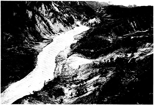
FIGURE 5.11 Upstream view of the Salado River showing remains (center foreground) of a debris flow that entered the river from the right (NE) valley wall. It is probable that this debris flow briefly dammed the river at this point.
Slope Stability—Preliminary Analysis and Interpretation
This discussion is restricted to the Reventador area because it contains by far the greatest concentration of landslides. The slides were shallow (average depth 2 m) and involved residual soil that became very fluid during failure. Stability thresholds as a function of slope angle are 35 to 40° for the main valley walls of the Coca and Salado rivers and 30 to 35° for the upper portions of the ancient Reventador Volcano cone. Field reconnaissance indicated that relatively few failures occurred on slopes flatter than these values and that most of the slopes with steeper angles did fail.
Evaluating the stability of the slopes in the Reventador area under earthquake loading provides insight into the general shear-strength behavior of these soils in particular and of residual soils in general. The stability of thin residual soils overlying high and steep slopes can be analyzed by an infinite-slope model. Further, the earthquake effects can be evaluated roughly by introducing a pseudostatic horizontal force that models the maximum horizontal acceleration. The analysis is carried out in terms of total stresses because evaluating the pore-water pressures at failure is impossible. Thus, the factor of safety can be defined as
where
ø, c = consolidated-undrained shear-strength parameters
H = depth of failure surface
γ = unit weight of soil
α = slope angle
k = seismic factor (maximum horizontal acceleration).
Ishihara and Nakamura (1987) used c = 0.3 kg/cm2 and ø = 30° to calculate a static factor of safety for the 45° slope that failed during the earthquakes and destroyed part of the pumping station on the Trans-Ecuadorian oil pipeline at Salado. The cohesion value was obtained from cone-penetration tests and an assumed reduction factor. The value of øcu (angle of internal friction based on consolidated-undrained conditions) would appear at first glance to be too high for undrained failure conditions (which we presume were considered by Ishihara and Nakamura), but, as discussed below, may be adequate for these particular failures. Landivar et al. (1986), in their general study of the lateritic soils of Ecuador, performed consolidated-undrained isotropic triaxial tests on soils just outside the Reventador zone. They obtained effective-stress strength parameters ranging from 0.05 to 0.08 kg/cm2 for c' (cohesion on effective-stress or drained basis) and 32 to
34° for ø' (angle of internal friction on effective-stress or drained basis). We have plotted the total-stress envelopes for these materials and, as expected, the average øcu values for the stress levels tested are in the range of 5 to 10°. The normal stress levels for 2-m-deep slides are not in excess of 0.5 kg/cm2; thus, these soils were tested at stress levels several times greater than field conditions at Reventador. A review of the literature on structured soils (loess, residual soils, sensitive clays) in general and of residual-soil case histories in particular shows that at very low stress levels the pore pressures at failure are close to zero or slightly negative (Vargas, 1974; Quigley, 1980; and Lum, 1982). As a consequence, the values of øcu and ø' are very similar, implying that the total-stress envelope has a strong curvature at low stress levels. For our range of interest, 0 to 0.5 kg/cm2, ø values typically range from 0 to 35°, and c values are generally less than 0.1 kg/cm2. Therefore, we fitted curved envelopes on the Landivar data and obtained øcu values between 30 and 38° and c values between 0.1 and 0.2 kg/cm2. These values are indeed very similar to the effective-stress parameters for other locations given above. Figure 5.12 shows the variation in the factor of safety as a function of slope angle for static conditions and maximum horizontal accelerations of 150, 250, and 350 gal. A value of a = 30° was used (øcu = 30° was also used), and the value of c = 0.14 kg/cm2 agrees well with the c values obtained from Landivar et al. (1986). It is seen that for the range of validity of Eq. (1), or values between 30 and 60° (which also happens to be the range of slope angles in the field), if instability is ssumed at øcu = 30° and k = 0.35, instability will begin at a = 40° for k = 0.25 and at a = 45° for k = 0.15. From our field observations, these values appear to be reasonable for the entire Reventador area, where the range of k probably falls within these limits. For comparison, Figure 5.13 shows a similar family of curves, but one in which øcu was assumed to be very low (5°), as compared with common assumptions for undrained conditions and a total-stress analysis. Again, c = 0.26 kg/cm2 was obtained by back calculation assuming FS = 1 and k = 0.35. The use of these strength parameters does not explain failures at angles >45° for k = 0.35 and, more significantly, predicts no slides at lower accelerations.
Furthermore, assuming natural variations in the strength parameters, low øcu and high c values do not explain our field observations. Figure 5.14 is a comparative plot in which FS was calculated for k = 0.35 and variations in the strength parameters. When øcu = 5° is assumed, a variation of about ± 0.05 kg/cm2, or about 20 percent, from the original 0.14 kg/cm2 value, gives the dashed curves shown in Figure 5.14. In one case, regardless of the slope angle, none of the slopes would fail, whereas in the other case all slopes would fail. However, even in the areas of maximum denudation, there is good correlation between slope angle and failure. On the other hand, when øcu = 30° is assumed, a variation in slope angle of ± 5°, or
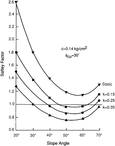
FIGURE 5.12 Pseudostatic and static safety factors vs. slope angle for øcu = 30° and c = 0.14 kg/cm2.
about 20 percent from the original 30° value, results in the solid lines in Figure 5.14. These lines indicate that instability for k = 0.35 begins on slopes of 35 and 25°, respectively; these slope-angle values still appear reasonable in light of our field observations.
Because these are such shallow slides, the cohesion value that is assumed
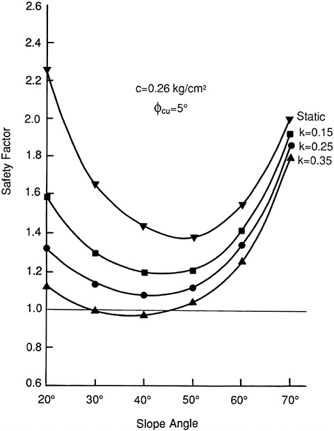
FIGURE 5.13 Pseudostatic and static safety factors vs. slope angle for øcu = 5° and c = 0.26 kg/cm2.
greatly influences the factor of safety even in the case of high øcu. For instance, the value c = 0.3 kg/cm2 used by Ishihara and Nakamura (1987) can explain the 5-m-deep slope failure at the Salado pumping station with a value of k = 0.35, but cannot explain the frequent shallower failures (commonly 1 to 2 m deep) observed nearby.
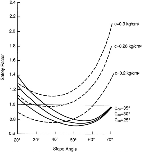
FIGURE 5.14 Comparative plot showing influence of variation in øcu and c on the factor of safety for k = 0.35.
Relation Between Denudation Intensity and Epicenter
Hakuno et al. (1988) questioned the accuracy of the positions of the epicenters that had been estimated by seismologists because the most severe slope failures occurred about 30 km from the reported epicenters. Ishihara and Nakamura (1987) placed the epicenters at 5 to 10 km from the headwaters of the Malo River and 10 to 15 km from the upper Salado River, presumably on the basis of denudation intensity.
Whereas the position of the epicenters may be open to question, we suggest that the increase in denudation near Reventador Volcano may also
be caused by other factors, namely relief, moisture conditions, elevation, and soil composition. The areas of near-total denudation on the SW slope of the ancient cone correspond to an area of deep and dense dissection by parallel gullies. Here, almost all the surfaces have slopes greater than 35 to 40°. Near-total denudation in areas of dissection by gullies also has occurred along the walls of the deep canyons of the Malo River (Figure 5.15), Morales Creek, Dué Grande River, and streams to the N of the Dué Grande. In contrast, the slope on the N side of the ancient cone, which is not deeply dissected, is far less affected by landslides, even though it is closer to the epicenters and is less than a couple of kilometers away from the area of almost total denudation. Along the walls of the Coca, slopes that are concave in profile, and therefore have steeper upper slopes and greater density of steep-sided gullies than slopes that are convex, have far greater concentrations of landslides. The same considerations apply to the Salado valley walls. Thus, it would seem that intensity of denudation is strongly controlled by density and depth of dissection, because these factors determine the percentage of slope surface greater than the threshold values.
Another factor controlling denudation may be local differences in degree of saturation of these residual materials. Degree of saturation greatly influ
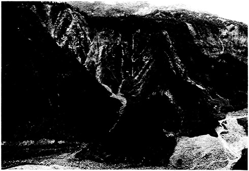
FIGURE 5.15 Aerial view of the NE valley wall of the Malo River showing extreme denudation of slopes due to slips/avalanches/flows and of the valley bottom due to debris flows and flooding. Note the vegetation trimline that indicates the maximum height of the debris flow/flood, about 25 m above the current river level.
ences cohesion (Brand, 1982; Ho and Fredlund, 1982), which, as noted previously, affects the pseudostatic factor of safety. The area around the Reventador cone has a wetter microclimate than the rest of the zone (E. Aguilera, personal communication, 1987); the INECEL station near Reventador Volcano has a mean annual precipitation of 6,868 mm.
Last, but not least, the materials near Reventador Volcano, being mostly residual soils formed on pyroclastic materials, may simply be more susceptible to failure.
EVOLUTION OF MASS-WASTING PROCESSES
One of the more striking characteristics of the mass wasting caused by the March 5, 1987, earthquakes was the effectiveness of the transport of materials from the slopes of the lowest-order tributaries to the flood plains of major streams. As mentioned previously, some reaches of the main rivers received as much as 20 m of sediment (measured in the center of the flood plains), most of which was landslide-generated. If we assume a triangular cross section for sediments in the valley bottom, an average width of 600 m for the Coca River floodplain, and a valley length of 20 km between the mouth of the Salado River and San Rafael Falls, we calculate a total volume of 120 × 106 m3. If we now assume an average depth of landsliding of 2 m (a reasonable value based on field observations), the denuded area was about 60 km2. The calculated volume compares well with the total volume (110 × 106 m3) of the mass wastage obtained by Hakuno et al. (1988). This volume attests to the fluidity of the debris flows and the effectiveness of the tributaries in transporting the debris materials. We suggest that two factors may have contributed to this large volume. The first is the nature of the soils involved in the slope failures, and the second is the general morphology of the Reventador area.
In general, the vast majority of the soils involved were tropical residual soils or relatively recent pyroclastic materials of various grain sizes (ash, lapilli, cinders, and pumice). Both of these types of soils have characteristically open structures, and hence high water contents when saturated. The natural water content is typically very close to or higher than the liquid limit. The pyroclastic materials have relatively low liquid limits and plasticity indices. However, the residual soils, being usually at advanced stages of laterization, have high liquid limits (up to 300 percent) and plasticity indices (up to 150 percent). The plasticity of such soils is the result not of high-activity clays, but of the presence of hydrated sesquioxides of Al and Fe in a gel state. In fact, residual laterites have very small or no clay content (Mitchell and Sitar, 1982). If present, clays tend to be of the halloysite type. Both the sesquioxides and halloysite suffer irreversible changes upon drying, and the soils undergo
dramatic decreases in plasticity (Mitchell and Sitar, 1982). These hydrated materials, which provide plasticity, behave as cementitious elements that impart physical cohesion to the soils. The open structures are preserved and the result is a brittle, open soil with high capacity to absorb water.
As shown in tests by Hakuno et al. (1988), the soils in the Reventador area fit this characterization well. These authors found natural water contents equal to or higher than the liquid limit, a wide range of plasticities, and absence of clay minerals. Pyroclastic materials, particularly those of fine grain size, also have open structures and relatively low plasticity. These two types of soils exhibit extreme loss of strength if they fall under undrained conditions. The first factor in these dramatic strength losses is the collapse (in the dehydrated residual soils); the second factor is the increase in pore pressures and the attendant decrease in effective stress.
The scenario postulated for the transport of the landslide materials is as follows: (1) Failure at a basal shear surface with an average depth of 2 m, probably at the bottom of the residual soil profile and at the top of the weathered rock. (2) Contractive behavior of the failed soil. Contraction decreases effective stresses until a steady-state strength is reached (Poulos et al., 1985; Ellen and Fleming, 1987; Fleming et al., 1989). Given the highly contracted behavior of the soils in this area, we can surmise that the steady-state strength of these soils is very low. (3) High-velocity flow down steep slopes that are several tens of meters to a few hundred meters long. (4) Movement of debris flows to the thalwegs of tributaries that do not have floodplains. Flow then was channeled and effectively conducted to channels of higher-order streams.
FLOODING OF RIVER VALLEYS IN THE VICINITY OF REVENTADOR VOLCANO
Crespo et al. (1987) roughly estimated that “ground shaking triggered mudslides and rock avalanches near the volcano involving more than 100 million cubic yards [76 million m3] of soil and rock.” Based on airphoto study of denudation of slopes in the vicinity of Reventador Volcano, Hakuno et al. (1988) estimated the total volume of slope failure at about 110 million m3, but noted that this approximation easily could have been in error by as much as 50 percent. Whichever of these estimates is the more accurate, a large percentage of this huge mass of material combined with water in the Coca and Aguarico Rivers and their tributaries to form thick debris flows that descended these tributaries of the upper Amazon.
Because these debris flows occurred at night, and thus were not easily observed, we are not sure of their character. We do not know whether they acted as true debris flows, or whether they might better be designated as
“hyperconcentrated flows” or “mud floods.” However, based on (1) depths of sediment deposited in the rivers, (2) “trimlines” on the lower valley walls, which indicated the heights to which the rivers rose when charged with the debris flows, and (3) damage to the Trans-Ecuadorian pipeline and highway due to deposition and erosion, we know that considerable flooding occurred (Figure 5.16A, Figure 5.16B, Figure 5.17A, Figure 5.17B, and Figure 5.18). Figure 5.19 indicates
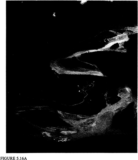
FIGURES 5.16 Aerial oblique views looking downstream at the confluence of the Salado and Quijos rivers to form the Coca River. (A) 1978 view (photograph by William Savage, Pacific Gas and Electric). (B) April 1987 view illustrating that braided debris-flow and flood deposits (as much as 20 m thick) have covered much of the
estimated depths of flooding and thicknesses of sediments deposited from the floods at several key locations along the Coca and Aguarico Rivers and their tributaries.
Because the stripping of earth materials from the slopes also removed the vegetative cover (mainly trees and brush), these large debris flows undoubtedly were charged with timber debris, similar to the debris flows that de-
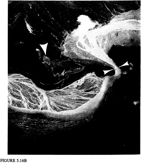
floodplain. Bedrock constriction of the Coca River (indicated by two arrows at the right) probably caused short-lived “hydraulic” damming of the river that contributed to upstream flooding and sedimentation. Note landslide (single arrow near center of photo) that badly damaged the Salado pumping plant of the Trans-Ecuadorian oil pipeline.
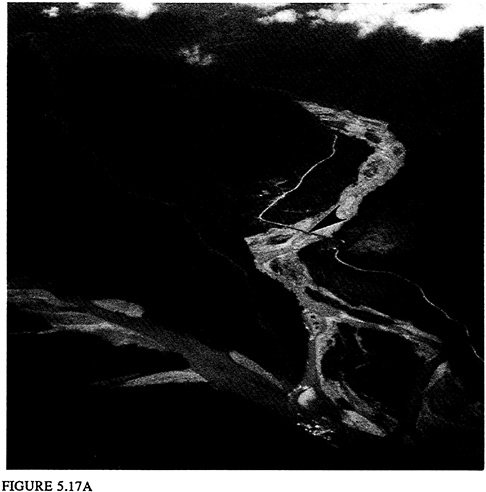
FIGURES 5.17 Looking up the Salado River from the confluence of the Salado and Quijos rivers. (A) 1978 photo showing the Trans-Ecuadorian highway bridge (arrow) across the Salado River. Note the Trans-Ecuadorian pipeline where it snakes down the ridge at the left to its crossing at the mouth of the Salado River.
scended the Toutle River in western Washington State as a result of the 1980 eruption of Mount St. Helens (Schuster, 1983). The addition of this timber debris undoubtedly affected the physical character of the debris flows, and as discussed below, probably impeded their passage through narrow bedrock constrictions in the narrow stream valleys.
As noted by Hakuno et al. (1988), a local resident who lived along the Coca River about 30 km from the epicenters of the earthquakes (most probably between the mouth of the Malo River and San Rafael Falls) reported that the Coca became completely dry soon after the earthquakes, which occurred at about 2100 and 2300 on March 5. Flow began again with a high
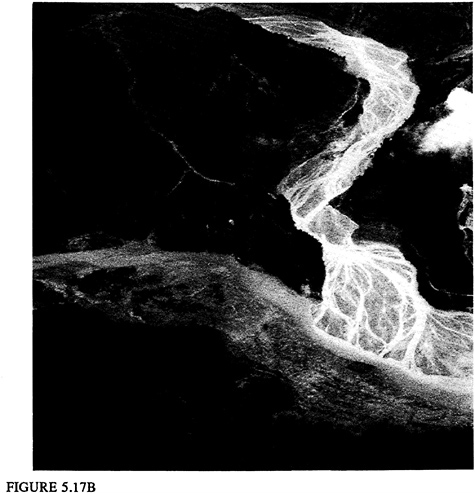
(Photograph by William Savage, Pacific Gas and Electric.) (B) April 1987 photograph showing extreme sedimentation in the Quijos, Salado, and Coca river channels due to the March 5, 1987, debris flows and flooding. Note absence of the Salado River highway bridge, which had been washed out.
flood at about 0300 on March 6. There is a strong possibility that this interruption of flow of the Coca River was the result of natural damming of the river and/or its tributaries as a result of the earthquakes. We feel that short-lived damming occurred in two ways: (1) “hydraulic ” damming, in which stream flow, highly charged with debris, was impeded in passing through narrow bedrock constrictions in the stream channels, and (2) blockage of streams by debris flows issuing into the main stream from its tributaries.
We have noted evidence of “hydraulic” damming at four locations in the Coca River drainage (Figure 5.19): (1) of the Salado River 7 km upstream from its confluence with the Quijos/Coca River (Figure 5.20), (2) of the
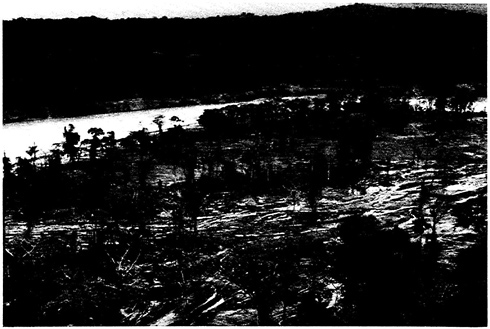
FIGURE 5.18 Evidence of March 5, 1987, flooding on the left (N) bank of the Aguarico River near the town of Lumbaqui. The flood has removed much of the vegetative cover from the low terrace in the foreground.
Malo River at its falls about 1 km upstream from its mouth, (3) of the Coca River at the bedrock peninsula that juts southward from the Salado pumping station (located at Salado), and (4) of the Coca River at San Rafael Falls. At each of these locations, the occurrence of damming is indicated immediately upstream by (1) trim lines showing the highest level of flow and (2) extensive deposits of sediment. The sediments probably were deposited in very short-lived lakes that formed as a result of damming at the constrictions before the debris “plugs” were flushed out.
The formation of temporary stream blockages by debris flows issuing from tributaries to dam the main stream has occurred in other parts of the world. For example, Montandon (1933) noted that the Upper Rhine River in Graubunden Canton, Switzerland, was briefly dammed in 1585, 1807, and 1868 by debris flows issuing from the Nolla Torrent. The Xiao River in northern Yunan Province, China, has been dammed briefly seven times in this century by large debris flows that issued from Jiangjia Gully, a major tributary of the Xiao. Each of these short-lived blockages of the Xiao River had heights of about 10 m, and most of them were overtopped and failed within a few days (Li et al., 1986). The Colorado River in the Grand Canyon was briefly dammed in 1966 by a cloudburst-triggered debris flow
from Crystal Creek (Webb et al., 1988). In the Reventador area, the only case of such debris-flow damming that we identified was caused by a flow that issued from the Malo River into the Coca River during the night of March 5-6. Apparently, this debris-flow blockage was no more than a few meters high, and it probably was overtopped and breached within an hour or two after forming. However, this low, short-lived dam must have been the main cause of the large amounts of sediment (estimated thickness: 20 m) that were deposited in the channel of the Coca River immediately upstream from the mouth of the Malo River (Figure 5.21). Possibly, another such debris-flow blockage occurred where the Salado River enters the Quijos-Coca River, because a large amount of sediment was deposited at this point (Figure 5.16 and Figure 5.17). The same process probably occurred on a smaller scale at other locations where steep gullies flow into the Salado (Figure 5.11), Malo, and Dué Grande rivers.
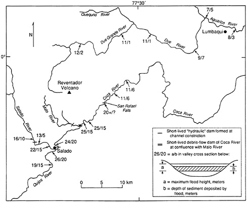
FIGURE 5.19 Estimated depths of flooding and sedimentation in river channels in the Reventador area. Estimates were based on low-level observations from a helicopter.
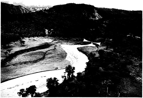
FIGURE 5.20 Downstream view of the Salado River showing location of bedrock constriction (arrows) that caused short-lived damming of the river. Note trimline in jungle cover along lower left valley wall upstream of the river constriction. This trimline indicates the maximum height (about 10 m above current river level) to which the debris flood rose.
Before the 1987 earthquake, plans had been made by INECEL to construct a 60 to 70-m-high embankment dam at the above-mentioned constriction of the Coca River at Salado. This dam would have formed a reservoir to serve as the source of water for an underground penstock that would reenter the Coca River at a powerhouse downstream from San Rafael Falls (Figure 5.7). Fortunately, construction of this dam had not begun by the time of the 1987 earthquake, and the project was deferred after the quake. However, INECEL is again considering plans for a dam at this site (El Comercio, 1990). The new project would entail a 5-m-high embankment dam at the same site on the Coca River; this low-head dam would store water for the aforementioned penstock and power plant.
REFERENCES
Baldock, J. 1982 . National Geological Map of the Republic of Ecuador . Dirección General de Geología y Minas, Quito, scale 1:1,000,000 .
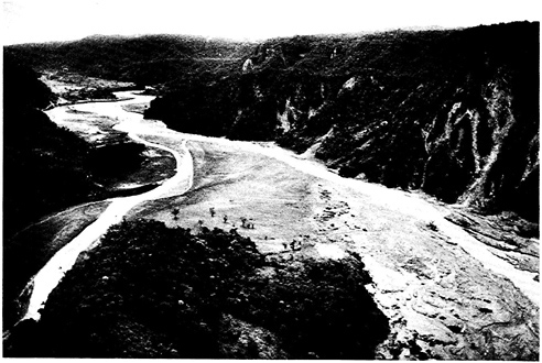
FIGURE 5.21 Looking downstream at the confluence of the Malo River (flowing from the lower left) with the Coca River. A debris flow issuing from the Malo River during the night of March 5, 1987, formed a short-lived dam of the Coca River, resulting in deposition of a large amount of sediment in the Coca channel in the right foreground.
Brand, E.W. 1982 . Analysis and design in residual soils . American Society of Civil Engineers, Geotechnical Engineering Division . Proceedings of Specialty Conference on Engineering and Construction in Residual and Tropical Soils, Honolulu, January 1982 , 89–143 .
Crespo, E. , and H. E. Stewart . 1987 . Stability of cut slopes in Ecuadorian volcaniclastic deposits . Proceedings 8th PanAmerican Conference on Soil Mechanics and Foundation Engineering , Cartagena, Colombia , 3 : 39–49 .
Crespo, E. , K. J. Nyman , and T. D. O'Rourke . 1987 . Ecuador earthquakes of March 5, 1987 . Earthquake Engineering Research Institute, EERI Newsletter , 21(7) : 1–4 .
El Comercio (Quito) . June 24, 1990 . Coca será una realidad .
Ellen, S. D. , and R. W. Fleming . 1987 . Mobilization of debris flows from soil slips, San Francisco Bay region, California , in J. E. Costa and G. F. Wieczorek , eds., Debris Flows/Avalanches: Recognition and Mitigation, Geological Society of America Reviews in Engineering Geology 7 : 31–40 .
Fleming, R. W. , S. D. Ellen , and A. A. Mitchell . 1989 . Transformation of dilative and contractive landslide debris into debris flows—an example from Marin county , California . Engineering Geology 27 : 201–223 .
Hakuno, M. , S. Okuna , and M. Michiue . 1988 . Study Report of Damage Done by the 1987 Earthquakes in Ecuador . Research Field Group, Natural Disasters and the Ability of the Community to Resist Them, Japan, Research Report on Unexpected Disasters No. B-62-2, 38 .
Hall, M. L. 1977 . El volcanismo en el Ecuador . Publicación del I.P.G.H., Seccion Nacional del Ecuador, Quito, 120 .
Ho, D. Y. F. , and D. G. Fredlund . 1982 . Increase in strength due to suction for two Hong Kong soils . American Society of Civil Engineers, Geotechnical Engineering Division. Proceedings of the Specialty Conference on Engineering and Construction of Tropical and Residual Soils , Honolulu , 263–295 .
Ishihara, K. , and S. Nakamura . 1987 . Landslides in mountain slopes during the Ecuador earthquake of March 5, 1987 . Proceedings of US-Asia Conference on Engineering for Mitigating Natural Hazards Damage , P. Karasudhi , P. Nutalaya , and A. N. L. Chiu , eds., Bangkok , 14–18 December C6–1 to C6–11 .
Keefer, D. K. 1984 . Landslides caused by earthquakes . Geological Society of America Bulletin 95 : 406–421 .
Landivar, H. , C. Luque , O. Ripalda , R. Maruri , and A. Fuentes . 1986 . Los suelos lateríticos en el Ecuador . Universidad Catolica de Guayaquil, Ecuador, 39 plus appendices .
Li Tianchi , R. L. Schuster , and Wu Jishan . 1986 . Landslide dams in south-central China, in Landslide Dams: Processes, Risk, and Mitigation , R. L. Schuster , ed., American Society of Civil Engineers Geotechnical Special Publication No. 3 , 146–162 .
Lum, W.B. 1982 . Engineering problems in tropical and residual soils in Hawaii. American Society of Civil Engineers, Geotechnical Engineering Division. Proceedings of the Specialty Conference on Engineering and Construction in Tropical and Residual Soils, Honolulu, January 1982 , 1–12 .
Mitchell, J. K. , and N. Sitar . 1982 . Engineering properties of tropical residual soils . American Society of Civil Engineers, Geotechnical Engineering Division. Proceedings of the Specialty Conference on Engineering and Construction in Tropical and Residual Soils, Honolulu, January 1982 , 30–57 .
Montandon, F. 1933 . Chronologie des grands éboulements alpins, du début de l'ère chrétienne à nos jours, in Matériaux pour l'Etude des Calamités , Société de Géographie Genève 32 : 271–340 .
Poulos, S. J. , G. Castro , and J. W. France . 1985 . Liquefaction evaluation procedure . Journal of Geotechnical Engineering, American Society of Civil Engineers 111(6) : 772–792 .
Quigley, R. M. 1980 . Geology, mineralogy and geochemistry of Canadian soft soils: a geotechnical perspective . Canadian Geotechnical Journal 17 : 261–285 .
Schuster, R. L. 1983 . Engineering aspects of the 1980 Mount St. Helens eruptions . Bulletin of the Association of Engineering Geologists 20(2) : 125–143 .
Vargas, M. ( 1974 ) Engineering properties of residual soils from south-central region of Brazil . Proceedings of the Second International Conference of the International Association of Engineering Geology, Sao Paulo, Brazil, 1 .
Webb, R. H. , P. T. Pringle , S. L. Reneau , and G. R. Rink . 1988 . Monument Creek debris flow, 1984: Implications for formation of rapids on the Colorado River in Grand Canyon National Park . Geology 16 : 50–54 .


