
PERMAFROST CHARACTERISTICS AND CHANGE
The most common and accepted definition of permafrost refers to the thermal conditions of the subsurface earth. Permafrost is defined as soil, rock, and any other subsurface earth material that exists at or below 0°C for two or more consecutive years (van Everdingen, 2005). This definition does not require the presence of ice. Because of this, the physical and biogeochemical properties of permafrost may vary widely depending on the characteristics of the parent material, ice and liquid water content, topography, biota, and climate. The complexity of permafrost evolution stems from its strong and nonlinear dependence on these ecological characteristics (Figure 1.1). Changes in permafrost are usually more complex than just a simple sum of changes induced by the variations in individual components of the environment. The resulting evolution of permafrost is usually even more complex because of the numerous reciprocal changes in other ecological components. Numerous positive and negative feedbacks exist between changing permafrost and other components of the Earth system, which make projections about permafrost change difficult. Among the most important impacts of changing permafrost environments are surface and subsurface hydrology, biota, biogeochemical processes in general, and the global carbon cycle in particular.
The formation, persistence, and disappearance of permafrost are highly dependent on climate because permafrost is a thermal condition. General circulation models project that a doubling of atmospheric concentration of carbon dioxide will result in mean annual air temperatures to rise up to several degrees over much of the Arctic. Discontinuous permafrost will likely ultimately disappear as a result of ground thermal changes associated with global climate warming, because ground temperatures in these regions are within 1-2 degrees of thawing. Permafrost degradation will have associated physical impacts where ground ice contents are high. Soils with the potential for instability upon thaw (thaw settlement, creep, or slope failure) may have significant impacts on the landscape (e.g., coastal erosion), ecosystems, and infrastructure.
Results from an international monitoring network of permafrost temperature measurements in boreholes (Thermal State of Permafrost) established by the permafrost research community clearly show warming of Northern Hemisphere permafrost in most regions as well as degradation in discontinuous permafrost regions during the last three decades (Romanovsky et al., 2010). In addition to impacts on northern hydrology and ecosystem characteristics (Hinzman et al., 2005), thaw also allows decomposition of sequestered organic matter, releasing currently stored soil carbon in the form of greenhouse gases (e.g., carbon dioxide and methane) to the atmosphere or to the hydrosphere (as dissolved and particulate organic carbon).
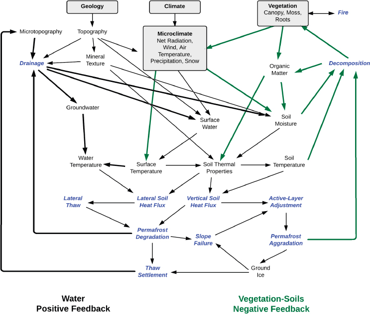
FIGURE 1.1 Conceptual diagram of ecological factors and feedbacks affecting permafrost aggradation and degradation that illustrates the complex interactions affecting the response of permafrost to surface boundary conditions and active-layer properties (Jorgenson et al., 2010). The text denotes properties (black text) and processes (blue text) that can be measured through remote sensing or field observations, while arrows indicate interactions among properties and processes. Black arrows indicate water positive feedbacks; green arrows indicate vegetation-soils negative feedbacks. Because permafrost properties, such as soil temperatures and ground ice, are difficult to measure through remote sensing, measurement of multiple surface properties and modeling will be needed to determine permafrost characteristics. SOURCE: Adapted from Jorgenson et al., 2010. © 2008 Canadian Science Publishing. Reproduced with permission.
DIRECT AND INDIRECT REMOTE SENSING OF PERMAFROST AND PERMAFROST-RELATED ECOLOGICAL CHARACTERISTICS
Permafrost thaw has wide-ranging impacts, such as erosion of riverbanks and coastlines, destabilization of infrastructure, and potential implications for ecosystems in the high latitudes, hydrology, and the carbon cycle. Data are needed to provide information on permafrost landscapes and on subsurface properties that determine the vulnerability of permafrost systems to warming. However, it is difficult to make in situ measurements of permafrost because of to the
remoteness and vast distribution of permafrost around the globe (Figure 1.2). The temporal evolution of permafrost triggers change in many other ecological characteristics, such as variations in micro-topography, local hydrology, and vegetation. Such changes may be observed remotely from space or from an aircraft using various sensors with high spatial resolution. The relationship between permafrost and other ecological characteristics provides an opportunity to observe and document changes in permafrost that otherwise would be difficult to detect. Thus, remote sensing techniques can be applied to observe and monitor permafrost using indirect indicators of permafrost evolution.
In this report, we discuss two types of variables that can be observed with remote sensing to study permafrost. “Permafrost-related ecological variables” refer to those properties that can be measured to provide some crucial information about changes in the relevant ecological characteristics and to extract information about permafrost conditions and processes. These variables support understanding and modeling of permafrost properties or permafrost changes. An example of a per-
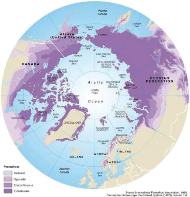
FIGURE 1.2 The distribution of permafrost in the Arctic. An updated circumpolar permafrost distribution map will be released once each Arctic country produces its own updated permafrost map. SOURCE: Philippe Rekacewicz, UNEP/GRID-Arendal (http://www.grida.no/graphicslib/detail/permafrost-distribution-in-the-arctic_3823).
mafrost-related ecological variable is the use of surface skin temperature to calculate the active layer thickness.
“Permafrost properties” refer to the essential key defining state variables of permafrost that then impact the ecological variables. These permafrost properties include
1. Ground temperature
2. Thickness of the active layer or the depth to the surface of permafrost
3. Thickness of permafrost
4. Spatial patchiness of permafrost
5. Ice content in permafrost
These properties describe where permafrost is, and what it is made of. Some of the variables were discussed in more detail at the workshop than others, which is reflected in the report. At present, considerably more ecological variables can be observed with remote sensing methods than can permafrost properties.
Any of the remote sensing methods, as well as any ground-based geophysical measurements, are indirect in comparison to truly direct methods of investigation such as drilling, in situ ground temperature measurements, and laboratory testing of samples collected in the field. Two types of approaches were discussed in the workshop for measuring both permafrost and ecological variables. “Direct” remote sensing methods can provide information about a variable of interest, such as ice content and permafrost temperature. “Indirect” methods incorporate modeling and remote sensing observations to estimate some crucial information about changes in the variable of interest (e.g., an ecological variable or a permafrost variable). One good example of an “indirect” method is the measurement of the evolution in micro-topography to estimate ice content in permafrost.
The Cryosphere Theme Report to the Integrated Global Observing Strategy (IGOS) partnership urges the development of remote sensing techniques to observe permafrost indirectly through connecting the observable land surface properties with subsurface permafrost characteristics (IGOS, 2007). The National Research Council (NRC) has recommended (NRC, 2007, p. 260) that “inferences be drawn from in situ measurements and remotely sensed observations from satellite and suborbital platforms.” To date, however, no strategy or NASA missions specifically address the scientific questions surrounding permafrost degradation (NRC, 2007, Table 9.A.1).
The most direct indicators of changes in permafrost are its temperature and the active layer thickness (ALT). ALT is the thickness of the top layer of soil and/or rock that thaws during the summer and freezes again during the following winter. Permafrost temperature is best used as an indicator of long-term change at a depth where seasonal variations in ground temperature cease to exist. This depth varies from a few meters in warm, ice-rich permafrost to 20 meters and more in cold permafrost and bedrock (Romanovsky et al., 2010; Smith et al., 2010; ). In addition, permafrost temperature is the best indicator of its stability. The closer this temperature is to the 0°C threshold, the less stable is the permafrost. Crossing this threshold triggers a widespread thawing of near-surface permafrost with negative consequences to the environment and infrastructure (Grosse et al., 2012; Instanes and Anisimov, 2008; Larsen et al., 2008).
Increases in the ALT may also trigger changes in other components of the system, even when permafrost is thermally stable with temperatures below 0°C. This may happen in areas with a large amount of ground ice. As soon as the summer thaw reaches the top of a very ice-rich layer or a pure-ice layer embedded in permafrost, any additional thaw triggers ground-surface subsidence. Because the distribution of ground ice is usually spatially uneven, the subsidence will develop a localized depression. Additional snow will collect during the winter and surface water will accumulate during the summer in this depression. Both of these processes will make the ground below the depression even warmer, and the local thawing of near-surface permafrost will progress more rapidly, developing into larger depressions, ponds, and eventually lakes. This process is called thermokarst formation and is typical within areas of degrading ice-rich permafrost. Development of thermokarst depressions and lakes will change local hydrology and have an impact on biota and trace gas emissions (Figure 1.3). This example highlights the importance of the volume and the morphology of the ground ice distribution as characteristics of permafrost. The impact of thawing permafrost on any infrastructure built above it also will strongly depend on these characteristics.
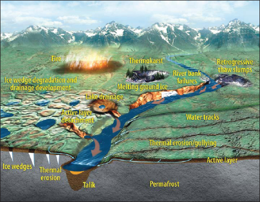
FIGURE 1.3 A schematic that illustrates the complex processes in a changing permafrost environment. SOURCE: Rowland et al., 2010.
U.S. AND INTERNATIONAL EFFORTS TO USE REMOTE SENSING TO STUDY PERMAFROST
Permafrost has been identified as an Essential Climate Variable in the Global Climate Observing System (WMO, 2010). Several national and international efforts have emerged in recent years to address how remote sensing can be used to study permafrost processes and change.
The planning committee was charged to recognize relevant efforts by NASA and other U.S. agencies. One key, emerging activity is ABoVE (the Arctic-Boreal Vulnerability Experiment),1 which will take place in Alaska and Canada during the next 6 to 9 years. ABoVE is planned as an international research initiative led by NASA to produce new knowledge needed to understand how climate change affects ecosystems in the High Northern Latitude region and how these changes produce feedbacks to climate and are influencing ecosystem services. ABoVE will acquire, process, integrate, and synthesize geospatial information products generated from a combination of airborne and spaceborne remote sensing observations with data from field studies and ground-based monitoring to address six primary research objectives: (1) impacts and responses of human societies to environmental change, (2) changes in disturbance regimes and their impacts, (3) drivers of permafrost change, (4) hydro-logic cycle change and its consequences, (5) flora and fauna responses to environmental change, and (6) the biogeochemical mechanisms driving change in soil carbon pools. ABoVE will emphasize integration and synthesis across these science themes.
Another relevant activity is the European Space Agency (ESA)-funded Data User Element (DUE) Permafrost Project (2009-2012). Its objective is to establish a permafrost-related monitoring system based on satellite remote sensing data. The international permafrost research community requires permafrost-related products at a variety of spatial scales. To this end, user organizations representing permafrost field investigators and modelers were involved in the early stages of the DUE Permafrost Project to define satellite-derived products and a satellite-based obser-
_______________
1 See http://csc.alaska.edu/projects/integrated-ecosystem-model.
vation strategy. The products identified by users were regional- and circumpolar-scale products consisting of land surface temperature (LST), surface soil moisture (SSM), frozen/unfrozen states of the ground surface, terrain parameters, land cover, and surface waters. The suite of data products developed and evaluated during the course of DUE Permafrost can be visualized and accessed via a Web-GIS Service2 and downloaded along with product documentation from PANGAEA (DUE Permafrost Project Consortium, 2012).
Experimental applications of the DUE Permafrost products are currently being developed. For example, within the European Union (EU)-funded project Changing Permafrost in the Arctic and its Global Effects in the 21st Century (PAGE21), which started in 2011, modeling groups are making extensive use of data products from DUE Permafrost. Experiments include the integration of satellite-derived products into permafrost models and the evaluation of output from regional climate models (e.g., spatial patterns of SSM and LST).
Another relevant activity is the Department of Energy-sponsored NGEE (Next Generation Ecosystem Experiments),3 which seeks to quantify the physical, chemical, and biological behavior of terrestrial ecosystems in Alaska through a coordinated set of investigations for improved process understanding and model representation of ecosystem-climate feedbacks. NGEE’s initial research will focus on thaw lakes, drained thaw lake basins, and ice-rich polygonal ground on the North Slope (Barrow, Alaska). The goal is to produce a process-based ecosystem model that can demonstrate the evolution of Arctic ecosystems in a changing climate with a high-resolution Earth System Model grid cell. NGEE will also include mechanistic studies in both the field and the laboratory; modeling of critical and interrelated water, nitrogen, carbon, and energy dynamics; and characterization of important interactions from molecular to landscape scales that drive feedbacks to the climate system.
A fourth related activity is the Integrated Ecosystem Model (IEM)4 for Alaska and Northwest Canada which is an effort to try and forecast landscape change within the Alaska and Northwest Canada region. This 5-year project, which started in 2011, uses three ecosystem models that link changing climate scenarios to different ecological processes. The goal of IEM is to generate maps and other products to illustrate how Arctic and boreal landscapes are expected to change due to climate-driven changes to vegetation, disturbance, hydrology, and permafrost. The products will also provide the uncertainty in the expected outcomes. IEM is sponsored by the Arctic Landscape Conservation Cooperative, the Northwest Boreal Landscape Conservation Cooperative, the U.S. Geological Survey Alaska Climate Science Center, and the Western Alaska Landscape Conservation Cooperative and is composed of members from different research communities, including the Geophysical Institute Permafrost Lab, the Institute of Arctic Biology, and the Scenarios Network for Alaska and Arctic Planning.
To complement the activities above, NASA asked the NRC to organize a workshop to explore opportunities for using remote sensing to advance our understanding of permafrost status and trends and the impacts of permafrost change (see Appendix C for Statement of Task). The workshop brought together experts from the remote sensing community with permafrost and ecosystem scientists. Participants represented academia, federal agencies, national laboratories, and the private sector; there was also international participation. In planning the workshop, the committee considered the other past and ongoing activities (discussed in the previous section) in developing the workshop agenda. The workshop discussions were designed to help the community articulate gaps in current understanding and identify potential opportunities to harness remote sensing techniques to better understand permafrost, permafrost change, and the implication of this change for the global carbon cycle in permafrost areas (see Appendix A for abstracts of the presentations and Appendix B for the workshop agenda and participant list).
Participants at the workshop addressed questions such as
_______________
2 See http://www.ipf.tuwien.ac.at/permafrost/.
3 See http://ngee-arctic.ornl.gov/about
4 See http://csc.alaska.edu/projects/integrated-ecosystem-model.
• How might remote sensing be used in innovative ways?
• How might remote sensing enhance our ability to document long-term trends?
• Is it possible to integrate remote sensing products with ground-based observations and assimilate them into advanced Arctic system models?
• What are the expectations of the quality and spatial and temporal resolution possible with such approaches?
• What prototype sensors (e.g., the airborne UAV SAR, AirMOSS, AIRSWOT, MABEL, IceBridge) are available and might be used for detailed permafrost studies after ground calibration to address many scientific and practical questions related to changes in high-latitude permafrost, including carbon cycle studies?
The workshop was divided into three plenary sessions: (1) measurement of permafrost properties, (2) measurement of related ecological characteristics, and (3) emerging remote sensing technologies and approaches for studying permafrost. Significant time was also spent in breakout groups to discuss current and future approaches for remotely sensing permafrost and ecological variables (see Tables 2.1 and 2.2). The focus of the workshop was on Arctic permafrost, although many of the remote sensing technologies discussed in the report could be applied in general to other types of permafrost such as mountain permafrost.
This report summarizes the views expressed by individual workshop participants. Although the committee is responsible for the overall quality and accuracy of the report as a record of what transpired at the workshop, the views contained in the report are not necessarily those of all workshop participants, the committee, or the NRC.
Chapter 1 (this chapter) provides background on permafrost characteristics, how the permafrost changes over time, and how it may impact other ecological components. It also describes the role of remote sensing to map and monitor changes in Arctic permafrost. Related activities dedicated to better understanding permafrost through remote sensing are also discussed. Chapter 2 describes various permafrost properties and permafrost-related ecological characteristics that can be remotely sensed to understand and detect changes in permafrost. Chapter 3 looks to the future and discusses systems (airborne and satellite) that can be applied immediately, in the near term, and in the long term to study permafrost.
This page intentionally left blank.


