
3
Central Everglades Planning Project
Past NRC reports have emphasized the perils of slow restoration progress (NRC, 2008) and documented the declining trajectories of many ecosystem attributes that depend upon restoration of water flows to the central Everglades (NRC, 2012a). NRC (2012a) noted that significant progress has been and continues to be made to reduce phosphorus in the central Everglades through the state’s 20-year effort to construct and optimize stormwater treatment areas (STAs) and to encourage best management practices for improved source control. The $880 million Restoration Strategies project, launched in 2012, continues these efforts to attain compliance with water quality criteria in the remnant Everglades (see Chapter 4). However, little progress has been made in restoring flows in the central Everglades because implementation of the Comprehensive Everglades Restoration Plan (CERP) to date has been focused primarily on projects at the edges of the historic Everglades. As a result, declines continue in many of the characteristic features of the Everglades, such as ridge and slough and tree islands, and oxidation of peat alters the slope of the land surface that shapes water flow (as described in detail in NRC, 2012a). The reasons that CERP projects at the periphery of the remnant Everglades have progressed faster than projects in the central Everglades are complex, but include fewer stakeholder conflicts at the periphery of the Everglades and/or strong local stakeholder support for specific efforts. Additionally, the project planning process has been easily stalled by scientific or technical uncertainties, particularly in complex or contentious projects such as the Water Conservation Area 3 (WCA-3) Decompartmentalization and Sheetflow project (Decomp; NRC, 2007). Unresolved water quality issues were also significant barriers in the development of project plans to increase flow to the central Everglades. To address these concerns and expedite restoration of the central Everglades, key federal and state officials launched the Central Everglades Planning Project in October 2011.
The primary purpose of the Central Everglades Planning Project is restoration of more natural patterns of water flows in the central part of the Everglades
(WCA-3 and Everglades National Park). The U.S. Army Corps of Engineers (USACE) described the project purpose:
to redirect water that is currently discharged to the east and west coast estuaries from Lake Okeechobee and restore water flow to the south, allowing for restoration of natural habitat conditions and water flow in the central Everglades and reconnecting the ecosystem from Lake Okeechobee to Everglades National Park and Florida Bay (76 Federal Register, [December 2, 2011], 75539).
The scope of the project includes increments (or components) of a number of CERP projects described in the original restoration plan (USACE and SFWMD, 1999), such as the Everglades Agricultural Area Storage Reservoir, Decomp, seepage management, and rain-driven operations. The Central Everglades Planning Project shifts the planning emphasis from multiple independent project implementation reports (PIRs) to a regional integrated PIR for the first increment of restoration. Thus, the Central Everglades Planning Project is a critical component of the CERP. This chapter reviews the progress made on this effort and prospects for restoration of the central Everglades.
THE EXPEDITED PLANNING PROCESS
The Central Everglades Planning Project was one of five USACE projects chosen to pilot a new expedited planning process. The pilot process aimed to reduce the typical 6-year preauthorization planning time frame to 18-24 months, while still addressing all current legal and programmatic requirements (such as the National Environmental Policy Act [NEPA] and independent external peer review). The process required a shift toward more focused detailed analyses and risk-based project planning prior to authorization—detailed engineering plans would be deferred until after congressional authorization of a project. The process also relied upon frequent engagement of senior leadership (known as vertical team coordination) at key project phases or decision points. The pilot projects are just one component of the USACE planning modernization effort, which includes the “3×3×3 rule” that requires all feasibility studies to be completed within a target of 18 months, but no more than 3 years, at a cost of no more than $3 million, utilizing three levels of vertical team coordination, and a “reasonable” report size (Walsh, 2012). The 3×3×3 rule was applied to all feasibility studies that had not had a feasibility scoping meeting by December 2011. The Central Everglades Planning Project represented an extreme test of the expedited process, considering the complex nature of the project, the extensive stakeholder involvement, and the diverse objectives of various interest groups.
The Central Everglades Planning Project was launched in October 2011 with initial targets of January 2013 to produce a draft PIR and December 2013 for final approval by USACE headquarters (known as the Chief’s Report) and submittal to Congress for authorization (K. Taplin, USACE, personal communication, 2012). Staff from the USACE, South Florida Water Management District (SFWMD), Department of the Interior, and other federal, state, local, and tribal governments worked within the project delivery team (PDT) process on all aspects of technical planning. Integration of other stakeholder input occurred through the South Florida Ecosystem Restoration Task Force’s (Task Force’s) Working Group (see Stakeholder Engagement later in this chapter). The record of opportunities to engage other federal and state agencies and the general public was impressive. During the planning process there were
• 26 meetings of the PDT;
• 5 meetings of the full Task Force at which concepts and updates of the Central Everglades Planning Process were presented;1
• 15 public workshops; and
• 12 public meetings as part of the NEPA process,
in addition to numerous briefings for the SFWMD Governing Board, the Water Resources Advisory Committee, and the Task Force’s Working Group and Science Coordination Group. Additional “in-progress review” meetings were held at major decision points with the USACE Jacksonville District teams and leadership from USACE regional and headquarters offices.
The process was only slightly behind its original aggressive schedule through the first 15 months of effort, when the late introduction of new water supply issues added approximately 4 months to the process. The draft PIR was publicly released in August 2013. A longer-than-anticipated review process and unresolved policy issues further delayed the schedule. On May 23, 2014, the USACE Civil Works Review Board approved release of the final Central Everglades Planning Project PIR (contingent upon some revisions and concurrence by the SFWMD) for state, agency, and administration review, and a Chief of Engineers’ Report is anticipated in summer 2014 (delayed approximately 8 months from the original target). The report was not finished in time to be included in the Water Resources Reform and Development Act (WRRDA) of 2014, which was signed into law on June 10, 2014, authorizing 34 projects for which USACE Chief’s Reports were complete. This section summarizes the development of the Central Everglades Planning Project plan and key unresolved issues.
______________
Development of Alternatives
Alternative plans were formulated based on four spatially discrete subregions of the planning area. The subregions, divided by color-referenced boundaries shown in Figure 3-1 and listed here from north to south, are also characterized by their functions:
A. North of the Red Line represents the location of storage and treatment to reduce phosphorus loads and includes the Everglades Agricultural Area, Lake Okeechobee, and surrounding areas;
B. South of the Red Line is the area characterized by management measures for distribution and conveyance of water in northern WCA-3A;
C. The Green and Blue Lines represent the areas in southern WCA-3 and into Everglades National Park that are characterized by management measures for distribution and conveyance of water; and
D. The Yellow Line represents the location along the Lower East Coast Protective Area, which is the location of seepage management options to protect the lower east coast urban areas from flooding.
The PDT and stakeholders via the public workshops formulated management alternatives for each of the areas, starting from the north and working toward the south. The PDT used a variety of analysis tools, including spreadsheet-style screening models, an inverse model, and preliminary cost-effectiveness analyses, to identify the most promising management options and optimize the combinations of management measures within each region. In some areas, such as North of the Red Line (storage and treatment), a single option emerged as best. South of the Red Line (distribution and conveyance), two basic options emerged, while four suites of options were considered worthy of further analysis in the Blue/Green Line (distribution and conveyance in WCA-3) and Yellow Line (seepage management) areas (see Table 3-1). Some of the variation in proposed seepage management measures (Yellow Line) was determined by the upstream flow conditions created by the management options in the Blue/Green Line scenarios. The management options were formulated into four alternatives (Alt-1, Alt-2, Alt-3, and Alt-4) for further modeling analysis and evaluation. Detailed descriptions of the rationale behind the formulation of these four alternatives are documented in the draft PIR (USACE and SFWMD, 2013b).
Evaluation of Alternatives and Subsequent Refinements
Alternatives were evaluated using a variety of techniques, including hydrologic and ecological modeling to assess systemwide performance and detailed
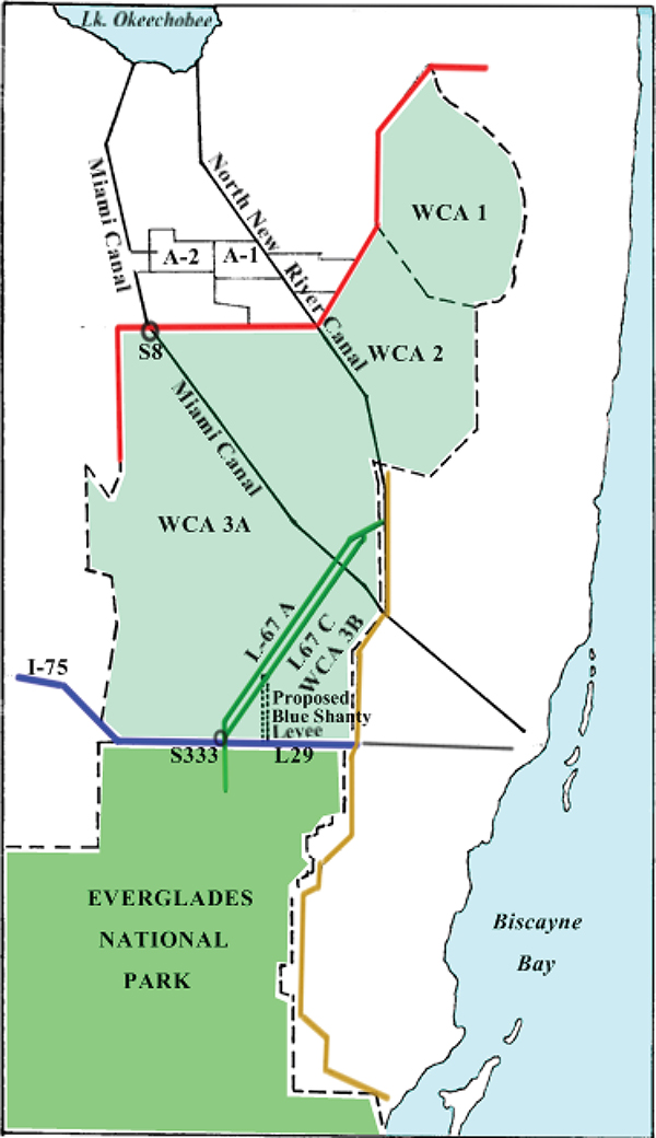
FIGURE 3-1 Subregions of the Central Everglades Planning Project Study Area.
SOURCE: Adapted from USACE and SFWMD (2013b).
TABLE 3-1 Summary of the Major Features of the Four Alternatives
| Zone | Features | Alt-1 | Alt-2 | Alt-3 | Alt-4 |
| North of Red Line | Storage/treatment | 28,000-acre FEB (A-2) Lake Okeechobee Operation Refinements | |||
| South of Red Line | Conveyance | Diversion of L-6 flows and L-5 canal improvements, removal of ~3 miles of the L-4 levee, G404 and S-8 pump station modifications | |||
| Spreader | Spreader canal ~3 mi west of S-8 (3,000 cfs) | Spreader canal ~3 mi west of S-8 (3,000 cfs), ~3 mi east of S-8 (800 cfs), and ~1.5 mi east of G-206 (400 cfs) | |||
| Backfill | Backfill Miami Canal from 1.5 mi south of S-8 to I-75 | Backfill Miami Canal from S-8 to I-75 | |||
| Blue/Green Line | L-67A Structures | One 750-cfs gated structure | One 750-cfs and two 500-cfs gated structures | Four 500-cfs gated structures | Three 500-cfs gated structures |
| Blue Shanty Levee with degrade of L-29 and L-67C in flowway | No | No | No | Yes | |
| 6000-ft gaps in L-67C | 1 | 3 | 4 | 1 | |
| Pumps and gravity structures | NA | One 500-cfs gravity structure out of WCA-3B | Two 500-cfs pumps out of WCA-3B | NA | |
| Yellow Line | S-356 pump | Increase to 1,000 cfs | |||
| Seepage barriers S-335 to S-334 | NA | Full depth | Full depth | NA | |
| Seepage barriers south of Tamiami Trail, along L-31N | NA | 2-mile partial-depth seepage barrier | 5-mile partial-depth seepage barrier | ||
| L-31N pumps | Two 250-cfs pumps | One 250-cfs pump | NA | NA | |
ecological and physical responses in specific subareas. Systemwide evaluation was based on multiple criteria as prescribed in the USACE’s Planning Guidance (USACE, 2000), including
• Effectiveness—the extent to which an alternative plan alleviates the specified problems and achieves specified opportunities;
• Acceptability—the workability and viability of alternatives with respect to acceptance by state and local entities and the public and compatibility with existing laws, regulations, and public policies;
• Completeness—the extent to which a given alternative provides and accounts for all necessary investments or other actions to ensure the realization of the planned effects; and
• Efficiency—the extent to which the alternative maximizes environmental benefits compared to costs, both overall and by individual project increments.
The effectiveness of each alternative was evaluated with a diverse set of performance measures—hydrologic surrogates for physical, chemical, and biological indicators of restoration progress. The study region was divided into 17 spatially distinct zones—two for the northern estuaries, six in the WCAs, three in Everglades National Park, and six in Florida Bay—each with specified performance measures that would be assessed relative to specific restoration objectives.2 Some of the performance measures, such as statistics of high and low flows in the northern estuaries and salinity in Florida Bay, were unique to particular zones, while other performance measures (e.g., ridge and slough inundation duration and sheet flow, drought intensity [a hydrologic surrogate for soil oxidation]) were common to several zones. Hydrologic models were used to evaluate the effectiveness of alternatives according to how well the targets for each performance measure were met, on a scale of 0 to 100. Zero represented a fully degraded ecosystem, and 100 represented full achievement of the restoration target.
To assess the efficiency of the project alternatives, “habitat units” associated with each alternative were calculated. First, a habitat suitability index (HSI; scaled from 0 to 1) was calculated for each of the 17 zones, based on an average of the performance measure values. The benefits model included an option to differentially weight the performance measures when calculating the HSI, but that option was not used, and all performance measures were assigned equal
______________
2 There were two performance measures for each of the northern estuaries, five for each zone in the WCAs and Everglades National Park, and one for each Florida Bay zone. In several cases, performance measures included submetrics that were then averaged to produce a single performance measure score.
weights. The overall habitat units associated with each alternative were calculated by multiplying the area of each zone by the HSI and adding the habitat units across the 17 zones. Habitat units generated by an alternative were then compared against a “future without the project” (FWO) scenario to calculate the “habitat unit lift” provided by that alternative (see Table 3-2). Habitat unit contributions were also annualized by incorporating estimates of the time it would take to realize the benefits.
After analysis and evaluation of the benefits of the four alternatives, several refinements were made to the alternatives. Analysis of the additional spreader and backfill features south of the Red Line in Alternatives 2, 3, and 4 (see Table 3-1) showed no additional environmental benefit, despite $130,000 additional cost (observed differences in benefits in southern WCA-3 were assumed to be dependent on other features). Thus, Alternatives 2, 3, and 4 were modified by using the conveyance features south of the Red Line of Alt-1, and an “M” was added to their labels.
The cost-effectiveness of alternatives, measured by the average cost per habitat unit lift, is shown in Figure 3-2. Alt-1 generated slightly more habitat units than Alt-2 and at a much lower cost. Alt-4 produced higher numbers of habitat units than any of the alternatives at a unit cost only $3 higher than Alt-1. When Alt-2, -3, and -4 were modified to include only the Alt-1 conveyance features south of the Red Line, Alt-1 and Alt-4M were judged to be cost-effective. Alt-4M became the most cost-effective option because it contributed substantially greater habitat units at the lowest cost per habitat unit.
In addition to the efficiency criterion, Alt-1 and Alt-4 also scored as high as or higher than Alt-2 and Alt-3 on USACE planning criteria of effectiveness, acceptability, and completeness. Acceptability was judged on the basis of documented concerns expressed by stakeholders (summarized in USACE and SFWMD, 2013b). Completeness was evaluated primarily by noting project
TABLE 3-2 Systemwide Habitat Units for Future Without Project Condition and Four Alternatives
| FWO | Alt-1 | Alt-2 | Alt-3 | Alt-4 | |
| Habitat units | 683,582 | 982,513 | 977,306 | 1,001,360 | 1,023,642 |
| Habitat unit lift | NA | 298,931 | 293,724 | 317,778 | 340,060 |
| Estimated cost (billion $)a | NA | 1.93 | 2.24 | 2.35 | 2.22 |
a Not including interest during construction.
SOURCE: USACE and SFWMD (2013b).
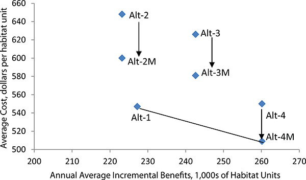
FIGURE 3-2 Cost-effectiveness of alternatives. Each alternative is located on the longitudinal axis by the increment of average annual habitat units and on the vertical axis by the average annual cost per average annual habitat unit.
SOURCE: Data from USACE and SFWMD (2013b).
dependencies of the Central Everglades Planning Project on other CERP and non-CERP projects (discussed in more detail later in this chapter).
Subsequent operational refinements were made to Alt-4M to increase confidence in satisfaction of the Savings Clause.3 The result, Alt-4R, was presented to the SFWMD Governing Board in February 2013 as the initial version of the Tentatively Selected Plan. In a presentation during the Governing Board meeting, it was noted that next steps included a “sequencing strategy, saving clause/project assurances analysis, draft preliminary operating manual, adaptive man-
______________
3 The Savings Clause is a provision of WRDA 2000 related to CERP implementation that is designed to ensure that an existing legal source of water (e.g., agricultural or urban water supply, water supply for Everglades National Park, water supply for fish and wildlife) is not eliminated or transferred until a replacement source of water of comparable quantity and quality—as was available on the date of enactment of WRDA 2000—is available and that levels of flood protection existing as of 2000 are not reduced.
agement plan, and a monitoring plan” (Minutes of Governing Board Meeting, Feb. 13, 20134). Issues regarding the Saving Clause and project assurances, cost sharing, and water quality issues were still unresolved when the board met on March 14, 2013, but the time required to resolve the issues was estimated to be 6-8 weeks. By the time the Governing Board met in April 2013, a new concern was added that had not been included in the original purpose of the project—the omission of “other project benefits to meet the additional water supply needs especially for the Lower East Coast and agricultural users” (Minutes of Board Meeting, April 11, 2013).
Alt-4R was subsequently refined to increase confidence in satisfaction of the Savings Clause and to increase public water supply deliveries. Addressing these issues to the satisfaction of stakeholders added about 4 months to the schedule before a draft of the PIR (USACE and SFWMD, 2013b) was published in August 2013. The further “refined” version of Alt-4R, referred to as Alt-4R2, was selected as the Tentatively Selected Plan in the Draft PIR (Figure 3-3). None of the refinements to Alt-4R involved changes to the major structural features shown in Table 3-1. Instead, Alt-4R2 included updates and changes to operating policies for Lake Okeechobee and the CERP Indian River Lagoon-South and Broward Water Preserve Areas projects, all within the limits of existing rules. Those changes provided an additional 12 million gallons per day (MGD) for municipal and industrial users in Lower East Coast Service Area 2 (Broward County) and 5 MGD to Lower East Coast Service Area 3 (Miami-Dade County).
The refinements made to Alt-4M to formulate the Tentatively Selected Plan came with a reduction in environmental benefits as measured by aggregate habitat units (see Table 3-3). There was a net decrease of 54,371 habitat units between Alt-4M and Alt-4R2, a decrease of 16 percent. Most of that loss was attributable to Savings Clause modifications from Alt-4M to Alt-4R, with the largest decreases in southern Everglades National Park, western Florida Bay, and east central Florida Bay. In further modifications from Alt-4R to Alt-4R2, it is unclear how the increase in water supply (not included in the original statement of purpose for the project; 76 Federal Register [December 2, 2011], 75539) impacted the overall benefits, because operational changes were made to provide more water than otherwise could have been provided to the natural system.
Unresolved Issues
After release of the PIR, the agencies conducted required reviews and worked to address several issues that were not fully resolved in the planning process,
______________
4 See http://www.sfwmd.gov/portal/page/portal/xweb about us/gb application/for all SFWMD Governing Board meeting minutes.
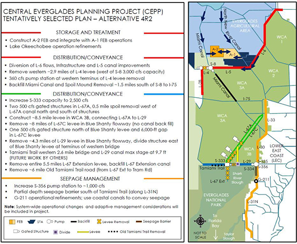
FIGURE 3-3 The Central Everglades Planning Project Tentatively Selected Plan, Alt-4R2.
SOURCE: USACE and SFWMD (2013b).
including phased implementation, revised systemwide operations, water quality, and impacts on threatened and endangered species. Some of these issues were resolved and others were deferred to more detailed post-authorization planning, engineering, and design. Among the most significant issues are
• Effects of water levels on threatened and endangered species; and
• Water quality, including effects of increased flows once the Central Everglades Planning Project is implemented.
TABLE 3-3 Habitat Unit Contributions of Alternatives and Changes Due to Refinements to
| Region | Future Without | Contributed HUs | Changes to Contributed HUs in Refinements to Alt-4 | ||||
| Alt-4 | Alt-4R | Alt-4R2 | Alt-4 to Alt-4R | Alt-4R to Alt-4R2 | Alt-4 to Alt-4R2 | ||
| Caloosahatchee Estuary | 34,070 | 4,968 | 4,968 | 4,968 | 0 | 0 | 0 |
| St. Lucie Estuary | 2,399 | 2,399 | 2,699 | 5,848 | 300 | 3,149 | 3,449 |
| Total northern estuaries | 36,469 | 7,367 | 7,667 | 10,816 | 300 | 3,149 | 3,449 |
| Northeast WCA-3A | 29,634 | 66,677 | 62,972 | 61,738 | −3,705 | −1,234 | −4,939 |
| WCA-3A Miami Canal | 27,373 | 29,719 | 27,373 | 27,373 | −2,346 | 0 | −2,346 |
| Northwest WCA-3A | 30,266 | 23,228 | 23,932 | 23,932 | 704 | 0 | 704 |
| Central WCA-3A | 105,669 | 4,117 | 4,117 | 5,490 | 0 | 1,373 | 1,373 |
| Southern WCA-3A | 68,423 | 0 | 0 | 0 | 0 | 0 | 0 |
| WCA-3B | 48,842 | 5,998 | 9,426 | 10,283 | 3,428 | 857 | 4,285 |
| Northern ENP | 55,054 | 47,547 | 43,793 | 43,793 | −3,754 | 0 | −3,754 |
| Southern ENP | 126,454 | 62,034 | 42,946 | 42,946 | −19,088 | 0 | −19,088 |
| Southeast ENP | 81,062 | 2,702 | 4,054 | 2,702 | 1,352 | −1,352 | 0 |
| Total Greater Everglades | 572,777 | 242,022 | 218,613 | 218,257 | −23,409 | −356 | −23,765 |
| Florida Bay West | 20,534 | 31,590 | 18,954 | 20,534 | −12,636 | 1,580 | −11,056 |
| Florida Bay Central | 8,205 | 9,025 | 5,743 | 6,564 | −3,282 | 821 | −2,461 |
| Florida Bay South | 14,659 | 20,523 | 12,705 | 13,682 | −7,818 | 977 | −6,841 |
| Florida Bay East Central | 20,225 | 26,381 | 13,191 | 14,070 | −13,190 | 879 | −12,311 |
| Florida Bay North Bay | 2,028 | 887 | 506 | 633 | −381 | 127 | −254 |
| Florida Bay East | 8,685 | 2,265 | 1,133 | 1,133 | −1,132 | 0 | −1,132 |
| Total Florida Bay | 74,336 | 90,671 | 52,232 | 56,616 | −38,439 | 4,384 | −34,055 |
| Total All Regions | 683,582 | 340,060 | 278,512 | 285,689 | −61,548 | 7,177 | −54,371 |
Note: Shadings represent the areas of largest habitat unit declines between Alt-4 and Alt-4R2.
SOURCE: Data from USACE and SFWMD (2013b).
The U.S. Fish and Wildlife Service (FWS) issued a Biological Opinion for the Central Everglades Planning Project in December 2013 (revised in April 2014) in which it came to the preliminary conclusion that “the proposed project is not likely to jeopardize the continued existence” of the Cape Sable seaside sparrow, snail kite, and wood stork and “is not likely to adversely modify critical habitat, where designated” (FWS, 2014). The Biological Opinion concluded that the project would provide some benefits to all three species, but the FWS
was not able to predict the overall impacts to the three species because of the many uncertainties related to project design, operations, and the time line for project implementation. For the sparrow, which has a relatively narrow range of hydrologic conditions that provide suitable habitat, the FWS noted that projected adverse effects on one subpopulation (E) could outweigh the small benefits projected for subpopulation A. The single large subpopulation (B), which comprises roughly 80 percent of the total population, is projected to be relatively unaffected by the Central Everglades Planning Project (FWS, 2014). Providing suitable habitat for sparrows and avoiding adverse effects on their population promise to be ongoing challenges during implementation of the project. FWS (2014) concluded that incidental take of all three species is likely but did not authorize incidental take. This means that further consultation will be necessary as specific project details are finalized and increments of the project are implemented.
Storage and treatment measures included in the Central Everglades Tentatively Selected Plan are designed to keep phosphorus levels in compliance with water quality-based effluent limits (WQBEL)5 for the STAs while allowing additional flows of approximately 210,000 acre-feet per year (AF/yr). However, this plan builds upon existing projects now under construction by the SFWMD to bring current flows into compliance with the WQBEL, and there is some uncertainty about the time line of meeting these water quality objectives (see also Chapter 4). Also, there is uncertainty about how implementation of the Central Everglades Planning Project will affect compliance with water quality criteria downstream in Everglades National Park. The methodology within Appendix A of the 1991 Settlement Agreement that determines compliance with state phosphorus standards is a flow-weighted mean phosphorus limit that was developed based on the observed relationship between water flow and phosphorus concentrations entering the park. Both the quantity and the spatial pattern of flow will be modified by implementation of the Central Everglades Planning Project. The Draft PIR (USACE and SFWMD, 2013b) stated:
Over the long-term, distributing the flow over the northern WCA-3A marsh, reducing short-circuiting down the canals to Everglades National Park, adding more flow from the lake that is treated to the WQBEL, and distributing these flows over the marsh should result in improvements by lowering the flow weighted mean total phosphorus concentration entering the Park.
______________
5 The WQBEL is a numeric discharge limit used to regulate permitted discharges from the STAs so as not to exceed a long-term geometric mean of 10 μg/L within the Everglades Protection Area. This numeric value is now translated into a flow-weighted mean (FWM) TP concentration and applied to each STA discharge points, which now must meet the following: (1) the STAs are in compliance with WQBEL when the TP concentration of STA discharge point does not exceed an annual FWM of 13 μg/L in more than 3 out of 5 years, and (2) annual FWM of 19 μg/L in any water year (Leeds, 2014). See Chapter 4 for more details on STA performance.
The Everglades Technical Oversight Committee established by the 1991 Settlement Agreement has been charged with reviewing the applicability of the current version of Appendix A to the restored ecosystem and whether changes are necessary in the context of the increased inflows to Northeast Shark River Slough.
Neither of these issues is likely to be resolved with confidence in the near future. The ongoing Restoration Strategies project to bring concentrations in existing outflows from STAs into compliance with WQBELs is not estimated to be fully constructed until 2024, although the Central Flowpath projects, which would receive inflow from the Central Everglades Planning Project FEB, are expected to be completed by 20166 (see Chapter 4). The 2012 Consent Order allows for up to a 5-year period for determining compliance with the WQBEL after construction is completed. SFWMD staff have stated that the STAs are currently permitted as a package, and therefore, the entire system must meet the WQBEL before existing flows can be redistributed or additional flows can be initiated (E. Barnett, SFWMD, personal communication, 2013)—potentially 2029 or later.7 Although water quality models have predicted compliance sufficiently well to justify expenditures for corrective actions, actual post-construction water quality will be a determining factor in how to proceed at that time. After an extensive review period, the USACE Civil Works Review Board considered the remaining unresolved issues and unanimously approved moving forward with the project. As discussed previously, the Chief of Engineers has initiated the concluding administrative steps of preparing a final project report and recommendation to Congress.
ASSESSMENT OF THE CENTRAL EVERGLADES PLANNING PROJECT
This section includes the committee’s assessment of the Tentatively Selected Plan, efficiency analyses used to select the plan, and the implementation plan. The committee also assesses the adaptive management plan, the expedited process, and stakeholder engagement.
The Plan
If implemented in a timely manner, the Tentatively Selected Plan for the Central Everglades Planning Project would make substantial improvements toward
______________
6 The 2014 South Florida Environmental Report (Leeds, 2014) reports that the Restoration Strategies project features are anticipated to be completed for the Central Flowpath by July 2016, for the Eastern Flowpath by December 2018, and for the Western Flowpath by December 2024.
7 After release of the report in prepublication form, it was pointed out that this sentence could be read to imply that SFWMD is responsible for assessing permit compliance. FDEP, with oversight from EPA, will interpret permit and Consent Order compliance, including any water quality issues that may affect flow redistribution.
the goal of restoring the Everglades. It would make significant improvements to the storage capacity and treatment performance of existing STAs by means of a new 56,000-AF flow equalization basin. When combined with adjustments to the regulation schedule in Lake Okeechobee operations, the flow equalization basin will allow an additional 210,000 AF/yr of water to be treated by the STAs and delivered to the remnant Everglades ecosystem that would otherwise be discharged through the Caloosahatchee River and St. Lucie Canal. This represents a 21 percent increase over existing flows (Figure 3-4) and approximately two-thirds of the new water envisioned by the CERP to be delivered along the northern end of the WCAs.
The Central Everglades Planning Project will also shift the distribution of water in the southern part of the system toward historical patterns, increasing flows into Northeast Shark River Slough and reducing flows into Western Shark River Slough. Excessively wet conditions in southwestern WCA-3A and adja-
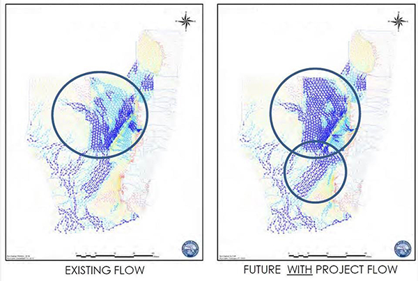
FIGURE 3-4 Central Everglades Planning Project existing and future flows. The graphics represent the average annual overland flow from 1965 to 2005. The direction of the arrows represents the movement of water across the landscape, and the colors represent the relative volume of water flow, with dark blue being the highest and red being the lowest.
SOURCE: USACE and SFWMD (2013b).
cent portions of Everglades National Park and excessively dry conditions in the eastern portion of the park have contributed greatly to ecosystem degradation in those areas (NRC, 2012a).
Systemwide, the plan improves ecosystem conditions (as measured in habitat units) by more than 40 percent over the future without the project, and in none of the 17 geographic areas would the condition be made worse overall. Northern estuaries would improve by 30 percent, the Greater Everglades (consisting of the WCAs and Everglades National Park) by 38 percent, and Florida Bay by 76 percent. Northwestern portions of the WCA-3 that have been subject to frequent dryouts would be rehydrated (USACE and SFWMD, 2013b). Northeast Shark River Slough on average would receive an additional 250,000 AF/yr of overland flow compared with the future without the project (D. Crawford, USACE, personal communication, 2014); however, an additional 500,000 to 700,000 AF/yr may be necessary to bring Florida Bay to full restoration. Ecological and hydrologic connectivity of the WCAs and Everglades National Park would be enhanced by partially degrading the L-67C and L-29 levees, and protective water depths in the eastern parts of WCA-3B would be maintained by the Blue Shanty Levee (USACE and SFWMD, 2013b).
Although improvements to estuaries of the Caloosahatchee River and St. Lucie Canal were not primary objectives of the Central Everglades Planning Project, water quality in those estuaries would be enhanced to some degree by diversion of flows to the Everglades. Damaging high-flow events (>2,800 cfs) in the Caloosahatchee would be reduced by 14 percent when compared with the future without condition; high-flow events (> 2,000 cfs) in the St. Lucie would be reduced by 34 percent. Low-flow events below desirable rates would be reduced by 15 percent in the Caloosahatchee and 29 percent in the St. Lucie (USACE and SFWMD, 2013b). Water available for existing users would be maintained, and a modest increase of 17 MGD would be added for urban, industrial, and agricultural water supply along the lower east coast.
In summary, the proposed plan offers significant benefits that should make important strides toward reversing ongoing declines in the remnant Everglades ecosystem and enhancing the condition of Everglades landscapes and species. The project is one of the first CERP efforts to have successfully integrated water flow restoration with water quality restoration. Overall, the plan is an impressive response to the need to accelerate the pace of restoration of the central Everglades.
Efficiency Analysis
The use of habitat units for quantifying environmental restoration benefits (discussed previously in this chapter) is included in Appendix E of the USACE planning guidance (USACE, 2000). That document, however, does not provide
guidance as to how habitat units are to be estimated for complex multifunction, multispecies projects such as the Everglades. The habitat unit approach evolved out of the Habitat Evaluation Procedure (FWS, 1980) that was developed and formally adopted for evaluation of effects on habitats of a single species. The CERP applies the metric as an area-weighted performance measure, but there are inherent flaws in its application to the optimization of environmental benefits in such highly complex environments. First, it involves simple addition of changes to very dissimilar environmental effects. For example, area-weighted performance measures for changes in high- and low-flow patterns in estuaries are added to area-weighted measures for changes to ridge-and-slough topography when there is no obvious common effect between the two ecological settings. Second, all performance measures are judged to be equally important, weighted only by the size of zones to which they are applicable.
This second issue has proved especially problematic for integrating restoration with recovery of threatened and endangered species, such as the Cape Sable seaside sparrow and the snail kite. For example, take two areas: Zone A with 100 acres of critical habitat for an endangered species, and Zone B with 1,000 acres of relatively abundant habitat not used by this species. If an alternative improves the condition of Zone A by 50 percent and Zone B by 25 percent and the average cost of improvements are the same, the 50-habitat-unit lift generated in Zone A represents only one-fifth of the 250-habitat-unit increase in Zone B. If tradeoffs are necessary to achieve optimal environmental benefits under a financial or water-budget constraint, investments to improve Zone B would be far more highly valued than the same investment to improve critical habitat for the endangered species in Zone A. Comparisons of highly aggregated sums of habitat units across disparate environmental settings thus can obscure the implicit tradeoffs that are being made between underlying ecosystem values. Critics have argued that application of habitat suitability analysis to multiple species is inappropriate, and in the context of the Central Everglades Planning Project, it was applied to very different physical and biological processes that not only impact multiple species but also a vast array of other environmental benefits. Indeed Alt-4R2 is projected to have negative impacts on endangered bird species in some locations (FWS, 2014) as was discussed previously. Protection of endangered species will ultimately require additional detailed analysis beyond the simple, habitat unit approach used to calculate environmental benefits, possibly resulting in some future modifications to project design.
The quest for a single benefit metric by which to compare alternatives is as old as benefit-cost analysis, but, so far, a fully satisfactory answer remains elusive. Promising advances have been made in the field of evaluating ecosystem services, but much work remains before a comprehensive model could be applied to the wide array of complex, interactive physical, chemical, and bio-
logical processes that make up the Everglades ecosystem. A recent report on an ecosystem services approach to damages resulting from the Deepwater Horizon oil spill in the Gulf of Mexico outlines a model for analysis based on fundamental concepts of microeconomics and discusses obstacles to its implementation (NRC, 2013). Prior research and monitoring of the Everglades makes it a better understood system than the impacted area of the Gulf. However, the lack of well-defined ecosystem service production/response functions that relate specific increases in ecosystem services in the Everglades to specific project attributes (i.e., how much “lift” is achieved by the project for each of the identified ecosystem services) remains an important obstacle. Another obstacle to implementation common to both cases is the lack of a set of well-defined, relative values for the diverse array of ecosystem services, many of which remain difficult to assess in monetary terms. Evaluation of all services need not be in monetary terms, but, if tradeoffs are necessary for optimization under constrained budgets, there must be a well-defined set of preferences (or weights) among different kinds of services.
There were no such well-defined preferences for the Central Everglades Planning Project process,8 and it was not made clear what substitution of services were being made as alternatives were being formulated, evaluated, modified, and refined. In the absence of a well-defined set of preferences or weights for diverse environmental benefits, a display of marginal differences of performance measures in the evaluation of effectiveness across the alternatives would be useful. Such a display enhances transparency and understanding of the inherent tradeoffs associated with alternative plans. Section 5 of the Draft PIR and supporting appendices (USACE and SFWMD, 2013b) provide considerable detail of environmental impacts of the final array of alternatives and the Tentatively Selected Plan. What are not clearly shown and summarized in those displays are the principal tradeoffs among alternatives as measured by performance measures and related ecosystem effects that were made in moving from Alternative 4 to the Tentatively Selected Plan. Changes (reductions) to aggregated habitat lifts were reported by zone, but changes to the performance measures underlying aggregated measures are not made clear. Those would be informative additions to the evaluation.
Implementation Plan
The strategy for implementing the Tentatively Selected Plan received considerable attention in the planning process. Initial development of an implementation plan focused on recognizing constraints and dependencies, basic
______________
8 The Central Everglades Planning Project attempted an evaluation of ecosystem services, but data were lacking to support a comprehensive analysis (K. Whittmann, USACE, personal communication, 2013), and the results were not published in the August 2013 draft PIR.
sequencing of project features, reasonable estimates for cost and schedule, and appropriate contingencies for the current level of design detail. The stated goal was to realize restoration benefits as soon as practicable, while still adhering to all water quality and other permitting requirements. The project team analyzed variations of the implementation plan, ranging from a scenario with largely unconstrained resources as a best-case to a more likely scenario governed by moderate annual expenditures. The best case could provide full restoration benefits 6 years after the Restoration Strategies water quality projects are permitted. A more realistic schedule considering $100 million/year funding would have those same benefits available by approximately 2053. To better understand these timing differences, the committee looked further into the governing constraints, sequencing of project components, and implementation uncertainties. Constraints and dependencies fell generally into four categories: physical (including planning and design), operational (hydrology), operational (permitting and compliance), and fiscal/funding (Table 3-4).
The dependencies, principles, and geography led to a simple, conceptual organization of the Tentatively Selected Plan into three component projects, each with a separate project partnership agreement (PPA): PPA North, encompassing spreading and backfill projects in northern WCA-3A; PPA South, representing distribution and sheet flow features in southern WCA-3A and Everglades National Park; and PPA New Water, representing the new storage and seepage management features (see Box 3-1). The relationship between the implementation constraints and the three PPAs is also shown in Table 3-4.
From a construction/implementation point of view, the three PPAs were configured to be independent from one another; the operational dependencies were confined within each PPA. Sequencing of the three PPAs could thus be in any order or even concurrent. However, funding realities are likely to limit the potential to significantly overlap the PPAs. PPA North alone yielded approximately 17 percent of total project benefits at 33 percent of the total cost, with the greatest benefit contribution to WCA-3A (Figure 3-5). PPA South alone provided about 21 percent of the total benefits at 22 percent of the total cost, with Everglades National Park followed by Florida Bay as the greatest beneficiaries. PPA New Water alone produced negligible benefits, but when PPA New Water followed the other two, its total contribution was approximately 62 percent of total project benefits at 45 percent of total cost. Figure 3-5 summarizes how the project phases contribute individually and together to each of the five regions.
This benefits distribution analysis seems to show that moving forward with PPA South first may have a slight edge in yielding early benefits, but the results are essentially equivalent. Thus, the sequencing of PPAs should be a future interagency decision that considers both existing constraints and potential for delivering the most early benefits, particularly to regions in decline that require
TABLE 3-4 Central Everglades Planning Project Implementation Plan Constraints and Dependencies
| Constraint, Dependency, or Principle | Rationale | PPA Constrained | ||
| PPA North | PPA South | PPA New Water | ||
| Physical, design and planning | ||||
| Availability of borrow material | Timing the availability of fill for Miami Canal backfilling and the Blue Shanty Levee minimizes costs | X | X | |
| Adaptive management plan | Allowing steps and timing to test concepts will improve future success | |||
| Operational (hydrology) | ||||
| A-1 FEB state restoration strategies | Required prior to implementation of northern WCA-3A distribution features to ensure adequate water quality of inflows | X | X | |
| C-358 and S-357N features | Construction of these seepage management features in Mod Waters is necessary to provide seepage mitigation before increasing flows into Northeast Shark River Slough | X | X | |
| S-356 Operation Plan | Operation of the existing S-356 pump station is required to provide seepage management before increasing flows into Northeast Shark River Slough | X | X | |
| C-111 South Dade | Completion of the detention areas required prior to significantly increasing flows to Northeast Shark River Slough to provide seepage management | X | X | |
| BCWPA C-11 Impoundment | Required prior to increasing flow through S-333 or implementation of WCA-3B inflow structures along the L-67A & C levees | X | X | |
| Tamiami Trail Next Steps bridging and road raising | Required prior to increasing capacities of S-333 and S-356 and implementation of WCA-3B inflow structures along the L-67A levee, gaps in L-67C levee and Blue Shanty flowway | X | X | |
| C-44 Reservoir (IRL-S) and connection to C-23 Canal | Required prior to redirecting the maximum amount of water from Lake Okeechobee south to meet environmental performance | X | ||
| Modification of the Lake Okeechobee regulation schedule | Changes to the 2008 LORS needed prior to full utilization of the A-2 FEB in order to achieve the complete ecological benefits | X | ||
| Outlet capacity of WCA-3A | Additional outlet capacity from WCA-3A must be provided before new project water from Lake Okeechobee is released into the system | X | ||
| Constraint, Dependency, or Principle | Rationale | PPA Constrained | ||
| PPA North | PPA South | PPA New Water | ||
| Operational (permitting and compliance) | ||||
| Restoration Strategies Permit Compliance | All features of the state’s Restoration Strategies must be completed and meet state water quality standards prior to initiating construction of most CEPP project features | X | X | X |
| Water Quality Compliance in Everglades National Park | Appendix A water quality compliance issues need to be addressed for new project water entering Everglades National Park | X | X | |
| Compliance with state water quality standards | Must first determine that feature will not violate state water quality standards, discharge limits, or permit conditions and it will not adversely affect flora and fauna in the area | X | X | X |
| Fiscal/Funding | ||||
| Funding availability | Pace of construction will be dependent on funding stream | X | X | X |
| State-federal cost-share balance | Total federal creditable expenditures cannot exceed state’s | X | X | X |
SOURCES: Based on information from Bush (2013); Barnett, SFWMD, and Hobbie, USACE, personal communication, 2013; E. Bush, USACE, personal communication, 2013.
long times to recover (NRC, 2012a). For the purposes of further analysis, the draft Implementation Plan utilized the PPA North → PPA South → PPA New Water sequence as a base.
Building on this base sequence and allowing for a small amount of overlap between PPA phases, the project team produced a Central Everglades project implementation schedule including recognized constraints and considering a nominal $100 million/year funding level. This scenario estimated 19 years from construction start to completion and was viewed as a realistic time line (although it lacked risk-based schedule contingencies). As an extreme, best-case scenario, executing all three PPAs concurrently with no resource constraints produced a total construction duration of 6 years (E. Bush, personal communication, 2014).
The initiation of construction of the Central Everglades Planning Project will be contingent upon numerous project dependencies (see Table 3-4), including improvements in water quality. The draft PIR includes the statement that “all features of the State’s Restoration Strategies must be completed and meet state water quality standards prior to initiating construction of most CEPP project features”
BOX 3-1
Proposed Groupings of Central Everglades Project Features
PPA North
- L-6 Diversion
- S-8 Pump Modifications
- L-4 Levee Degrade and Pump Station
- L-5 Canal Improvements
- Miami Canal Backfill
PPA South
- L-67A Structure 1 North
- One L-67C Gap
- Increase S-356
- Increase S-333
- L-29 Divide Structure
- L-67A Structures 2 and 3 South
- L-67A Spoil Mound Removal
- Remove L-67C Levee Segment
- Remove L-67 Extension Levee (no backfill)
- 8.5-Mile Blue Shanty Levee
- Remove L-29 Levee Segment
- Backfill L-67 Canal Extension
- Remove Old Tamiami Traila
PPA New Water
- Seepage Barrier L-31N
- A-2 FEB
aRemoval of Old Tamiami Trail can be completed at any time during implementation, but must precede backfilling of L-67 Extension Canal.
Source: E. Bush, USACE, personal communication, 2014.
(USACE and SFWMD, 2013b). Any project construction would require certification by the state that the project would not lead to a violation of state water quality standards. However, it does not necessarily follow that construction of most Central Everglades Planning Project components must be deferred until all components of the Restoration Strategies are implemented. For example, construction of the A-2 FEB and improved seepage management would only improve water quality and could provide a means to expedite overall construction in the face of other constraints. Combining the large contingencies resulting from funding with the stated implementation and permitting constraints driven by the Restoration Strategies project leads to a rather alarming picture of potential restoration prog-
FIGURE 3-5 PPA contribution to Central Everglades Planning Project benefits by region. PPA New Water benefits are dependent upon the completion of both PPA North and PPA South.
SOURCE: Based on information from E. Bush, USACE, personal communication, 2014.
ress. Figure 3-6 shows the serial effect of constraints, permitting, construction phasing, and contingency addition to the scheduled availability of project benefits—a scenario in which the first new water benefits occur approximately four decades into the future with funding of approximately $100 million/year in constant dollars. Allocating schedule contingency from Appendix B in USACE and SFWMD (2013a) proportionally to each PPA, the first benefits based on existing water could be about 21 years from now, assuming that Central Everglades Planning Project construction is not initiated until all of the Restoration Strategies projects have been permitted. At three decades into the future, realized benefits could still only be 38 percent or less of the full Central Everglades Planning Project. Different funding streams could produce different scenarios, and more recent updates to the cost engineering appendix of the PIR present even longer possible time frames.9
______________
9 Since the August draft PIR was released, the Cost Engineering Appendix B has been revised using a project duration of 329 months with a contingency of 89 months, for a total of 34.8 years at an 80 percent confidence level. This updated estimate reflects a scenario of $100 million/year, not adjusted for inflation (Amro Habib, USACE, personal communication, 2014). In contrast, the August draft PIR presented a schedule duration of 186 months with a contingency of 107 months, for a total of 24.4 years at an 80 percent confidence level (USACE and SFWMD, 2013a).
FIGURE 3-6 Schedule implications of serial phasing of state water quality construction, operations, and permitting of all STAs (as a unit), and Central Everglades project partnership agreement (PPA) construction. The years shown reflect the risk-based schedule according to USACE and SFWMD (2013b, Appendix B) of 186 months with an additional 107 months of schedule contingency (at 80 percent confidence), based on a $100 million/year constant dollar funding scenario. The 293-month total construction time (including contingencies) was apportioned to the three PPAs according to time lines presented in a draft constrained implementation schedule (E. Bush, USACE, personal communication, 2014).
The committee judges that this is an unreasonable and undesirable result. To avert continued ecosystem declines in the central Everglades, including some that would require decades to centuries to recover (NRC, 2012a), the Corps and SFWMD need to look for creative implementation strategies to reduce existing constraints. To take advantage of the likelihood that the Central Flowpath (STA-2 and -3/4) achieves compliance with the WQBEL much earlier than the remainder of the STAs (see Chapter 4), the agencies should investigate design, implementation, and permitting alternatives that would enable the Central Everglades Planning Project to move forward as quickly as possible with WQBEL-compliant discharges, This will require a thorough evaluation of the risks, costs, and benefits of such actions to the entire South Florida ecosystem and collaboration among multiple agencies and stakeholders. Additionally, an increased and consistent funding profile would have a major impact on achieving Central Everglades restoration goals sooner.
Adaptive Management and Monitoring
The Central Everglades adaptive management plan (USACE and SFWMD, 2013b) was developed to identify key areas where restoration efforts would
benefit from monitoring and assessment and outline how proposed and existing monitoring could be used to adapt project implementation to reduce uncertainties and improve restoration outcomes. Additionally, the plan was to document the monitoring necessary to meet project-specific regulatory and permit objectives. It is intended to serve as a guide on the use of monitoring data to maximize restoration benefits while reducing costs and to inform project design and implementation to improve performance. Hence, the adaptive management plan represents a highly ambitious balancing act, given the multiple objectives and the scope of the Central Everglades Planning Project.
The Central Everglades Planning Project adaptive management team identified key project uncertainties, defined as planning questions “regarding the best actions to achieve desired goals and objectives within constraints, which cannot be fully answered with available data or modeling.” These uncertainties reflect scientific understanding of the anticipated restoration responses to management actions rather than administrative and funding uncertainties surrounding scheduling and implementation. Based on criteria developed from RECOVER (2011a), the team screened and prioritized uncertainties, selecting only those uncertainties that
1. Are directly related to Central Everglades Planning Project goals, objectives, or constraints;
2. Are focused at the project scale;
3. Are not already well understood;
4. Have at least one measurable attribute that can provide information to resolve the uncertainty; and
5. Have adaptive management options (i.e., the ability to be addressed through adjustments to restoration plans).
The uncertainties identified were further prioritized according to three additional criteria:
1. The risk of not achieving restoration goals if the uncertainty is not resolved,
2. The level of knowledge about the uncertainty, and
3. The relevance or level of confidence that the uncertainty could be resolved.
Uncertainties that scored high on risk and relevance and low on knowledge were ranked higher than those with low risk and relevance and high knowledge. The highest priority uncertainties resulting from this process are listed in Box 3-2.
For each uncertainty listed in Box 3-2, the adaptive management plan includes information on the drivers of uncertainty, CERP- and project-level targets for ecosystem attributes related to the uncertainty, and a plan for monitoring
BOX 3-2
Central Everglades Planning Project Uncertainties
The following uncertainties were identified in Annex D of the Central Everglades Planning Project PIR (USACE and SFWMD, 2013b):
CEPP-wide: How will CEPP influence the introduction and growth of nonnative and native nuisance species within the project area, and will the species influence the predicted landscape and performance of CEPP?
Lake Okeechobee: Will CEPP’s operational refinements for Lake Okeechobee affect its littoral and nearshore vegetation coverage?
Flow Equalization Basins (FEBs): How can the operation of the FEBs be optimized to maximize flows to the Everglades while serving the needs of Lake Okeechobee and the northern Everglades?
Northern Everglades, St Lucie Estuary: Do reductions in high flows result in measurable increases in submerged aquatic vegetation (SAV) coverage in the estuary? To what extent will the reduction in the frequency and magnitude of high flows to the estuary stabilize conditions sufficiently to improve benthic habitat in the south fork of the estuary? To what extent will the reduction of frequency and magnitude of high flows to the estuary help reestablish historic oyster beds on the south fork of the estuary?
Northern Everglades, Caloosahatchee Estuary: Do reductions in high flows result in measurable increases in SAV coverage and oyster acreage and health in the estuary? Will the reduction in low-flow violations in the estuary help reestablish persistent Vallisneria beds in the upper estuary?
Greater Everglades: Are flow velocities, direction, volumes, and depth improvements from CEPP sufficient to reestablish historic ridge-and-slough landscapes? Can CEPP create hydrology favorable for tree island elevation requirements? Are inundation and hydroperiod sufficient to reduce current high rates of soil oxidation and peat fires?
the attributes to track progress toward the targets. The plan also discusses the time frame in which changes in the attributes will be measurable, and identifies triggers or thresholds that would give early warning that project performance is deviating from restoration goals. Management options are proposed that could then be chosen based on monitoring results. The adaptive management plan relies on data from hydrometeorological, ecological, water quality, and nuisance and exotic vegetation monitoring and, as such, is tightly connected to monitoring activities associated with project implementation within and beyond the Central Everglades Planning Project. Although new monitoring activities are proposed, the adaptive management plan also relies heavily on data from existing monitor-
How much will CEPP improve alligator relative density and body condition in northern WCA-3A and -3B and northeast Shark River Slough? How much will hydrologic restoration and vegetation management result in increases in prey densities? How much will hydrologic restoration and vegetation management result in increases in wading bird foraging conditions and increased nest number and success of wood storks and roseate spoonbills?
Greater Everglades/Lower East Coast: Will the full suite of CEPP TSP structures be required in WCA-3B to create the Blue Shanty Flowway?
Everglades National Park (ENP)/Southern Coastal Systems: Will there be downstream biogeochemical effects associated with modifying inflows and hydrologic conditions in ENP, including effects on nutrient movement, availability, and ecological responses? Will increased flows to northeastern Shark River Slough yield natural distribution of waters toward the southeastern Everglades and northeast Florida Bay without operation of the SFWMD Canal System east of L-30, L-31N, and L-31W? Will CEPP improve flows to Florida Bay and the lower southwest coast, resulting in more natural salinity patterns, and will responses be consistent with the expectations from the CEPP scenario model predictions? Will predicted CEPP flows mitigate saltwater intrusion and associated coastal wetland vegetation, soil stability, and nutrient retention or release? If salinity is affected by overland flow increases through ENP to Florida Bay, how much benefit is generated for SAV, prey, coastal wading birds, and crocodiles, and can operations be adjusted to improve estuarine performance in Florida Bay?
Lower East Coast: Will the constructed and operational features of CEPP maintain flood risk management level of service east of the L-30, L-31N, L-31W and C-111 without reducing quantity or quality of groundwater in water supply well fields compared to existing conditions? Will the constructed and operational features of CEPP reduce surface and/or groundwater base flows and wetland/groundwater recharge to the east of the L-30 and L-31N in areas such as the Pennsuco Wetlands, south Miami-Dade wetlands, and Biscayne Bay?
SOURCE: USACE and SFWMD (2013b).
ing and ongoing research (such as the Science Plan for the Everglades Stormwater Treatment Areas [SFWMD, 2013d] discussed in Chapter 7).
The Central Everglades Planning Project team has developed the most structured, complex, and comprehensive adaptive management plan within the CERP to date. Because it has been developed in tandem with the Central Everglades Planning Project process, rather than retrospectively, it exhibits greater integration, relevance, and coordination with implementation of the restoration plan. Thus, monitoring data derived from the plan are more likely to be useful for determining ecological responses to project implementation and the ability to meet restoration goals. Although the adaptive management plan is intended
to provide flexibility and robustness in the face of unexpected or surprising events (i.e., unknown uncertainties) within a highly dynamic system, aside from operational changes, much of the flexibility would be derived from future increments of restoration in the central Everglades, rather than within the project itself.
Although the plan addresses system dynamics and variability, it does not appear to take into account the strong likelihood of nonstationary processes (i.e., system dynamics in which the trend and variability change through time). This is particularly pertinent to the effects of climate change, for instance, where not only the average temperature and precipitation are projected to change, but temperatures and precipitation are projected to exhibit greater variance (Hansen et al., 2012) (see Chapter 5). Nonstationary systems and processes are notoriously difficult to monitor and manage because they turn what are assumed to be stationary baseline conditions, against which restoration responses are compared, into a moving target. For the Central Everglades Planning Project, and indeed much of the CERP, sea-level rise, climate change, and the introduction of new invasive species are perhaps the most prominent threats on the horizon that could impede the ability to measure restoration relative to starting conditions. These are also highly uncertain in their timing and projected effects on the system. In this context, flexibility to address these potentially disruptive uncertainties should be explicitly built into adaptive management and monitoring recommendations, and they should be made more explicit and expanded upon in the adaptive management plan.
Stakeholder Engagement
CERP stakeholders range across a diverse set of actors including, but not limited to, federal, state, and district agencies, tribes, environmental nongovernmental organizations and community groups, recreation groups, agricultural entities, and individual members of the general public. This is, in great part, due to the multiobjective and multifaceted nature of restoration in this region that cuts across social, economic, ecological, and hydrologic concerns over a broad landscape. The types of stakeholder engagement elicited during CERP project planning has typically focused on engaging other federal, state, local, and tribal government agencies as part of the project development team process. Under the Federal Advisory Committee Act (FACA), representatives from nongovernmental organizations, recreation groups, and agricultural interests are typically unable to actively and collaboratively participate in CERP project planning. Public participation in these meetings is typically limited to brief (2- to 3-minute) comments with no mechanism for discussion. Recognizing that greater acceptance is likely when stakeholders and the public are afforded opportunities to actively participate in the planning process, the USACE and the SFWMD
worked with the FACA-exempt Task Force to facilitate enhanced stakeholder engagement for the Central Everglades Planning Project.
Building on experiences gained through previous stakeholder processes, such as the state’s non-CERP River of Grass planning effort, the Task Force’s Working Group, the Science Coordination Group, and the SFWMD’s Water Resources Advisory Commission, moderated a total of 16 public workshops—many that were day-long or longer—that emphasized enhanced public and stakeholder engagement (Figure 3-7). This provided opportunities for two-way dialogue at a more detailed level and accommodated input from a broader representation of stakeholders and the public on the scope of the study; the
FIGURE 3-7 Public and stakeholder group workshops, showing feedback mechanism to the Corps and the SFWMD.
SOURCE: http://www.sfrestore.org/wg/wgminutes/2011meetings/11172011/Draft_Protocol.pdf.
development of goals, targets, and alternatives; and plan selection. One example of active input from stakeholders and the public was the use of configuration development exercises to elicit input on specific restoration strategies and implementation sequencing. Although not aiming for consensus, the results of the configuration development exercises allowed the Task Force to provide informed input to the Corps and the SFWMD during planning. Feedback from participants on the effectiveness of the enhanced public and stakeholder participation process, and the outcomes that have arisen from it, has been mixed. Feedback has been overwhelmingly positive about the extent to which the Corps and the SFWMD have reached out to a broad range of stakeholder and public entities to provide information and seek feedback, particularly with the recreation community. The configuration development exercises were regarded as valuable in soliciting input on some project components as they challenged participants to offer justified preferences for plans. This exercise ultimately influenced the recommendations, largely due to participation and feedback from the recreation community. Other aspects of the enhanced public and stakeholder participation process that were regarded as positive include a greater degree of two-way dialogue not seen in other planning endeavors in the CERP, the adoption of mechanisms to provide feedback and to change plans through more active and inclusive engagement, greater effort to explain the plan to broader stakeholder and public groups, and a more transparent planning process involving a more engaged community.
Opinion on the mechanism for feedback into the planning process (i.e., the process of using stakeholder comments, concerns, and suggestions to make changes) was mixed. Some stakeholders point to the change in alternatives based on concerns raised by the recreation community as evidence of a genuine feedback mechanism. However, others assert that the process by which feedback would be used to change plans lacked transparency from the outset, that input was accepted and acted upon on the basis of convenience and ease of implementation, and that disparate views across the broader stakeholder body were not addressed. It was the view of one stakeholder that most of the attention and discussion arising during workshops focused on the northern portions of the central Everglades because that is where most stakeholder and public interest lay; however, this led to incomplete or superficial consideration of the southern areas of the central Everglades and seepage issues.
Criticism has also been raised about the time frame of the Central Everglades Planning Project. Although a broad representation of stakeholders and the public was generally well informed by the process, those with knowledge of the CERP and the hydrologic models used in CERP planning had insufficient time and information to keep up with the dissemination of model output generated by the modeling team. Hence, stakeholders were limited in their understanding of
the modeling results to what the agencies presented, rather than being able to gain insights from their own analysis of the data.
Numerous challenges arose during the enhanced public and stakeholder engagement process. First, to comply with FACA, multiple duplicate meetings were necessary, causing meeting fatigue. The numerous day-long, information-rich public workshops created a very intense process that was challenging to keep up with. And although the process of stakeholder engagement was regarded as an improvement over previous planning efforts, disappointment was expressed that some key stakeholders did not actively participate in the process, because they were either absent or reticent.
On balance, this committee judges that the enhanced stakeholder and public engagement process was well executed and inclusive. Although the expedited time frame was likely too fast to ensure rigorous consideration of all components of such a complex project, this committee commends the efforts to structure stakeholder and public engagement to allow more active participation than in previous planning processes. The limitations incurred by an expedited planning time frame aside, the efforts to educate stakeholders and the public and to elicit comments, criticisms, and modifications to the Central Everglades Planning Project have been exemplary and should serve as a model for future planning processes.
The Process
Despite some delays in the schedule, the Central Everglades Planning Project team produced a public version of a decision document within approximately 22 months and is anticipated to have a Chief’s Report in a total of 34 months. Although there has been no formal survey of participants and stakeholders, it appears that the project was well administered, stakeholders were generally pleased with the opportunity to participate in the process directly, and it produced a useful product. Brief slippage in the schedule came in part because of extra time required to develop confidence that the project could satisfy the Savings Clause and provide project assurances as required in the authorizing legislation, but another contributing factor in the delay was the tardy insertion of concerns about additional public water supply that were not part of the early scoping process. That is a reality for all planning processes. It is not uncommon for some stakeholders to become engaged in a planning process after scoping has been completed or after initial plans have been formulated and evaluated. At that point, they are better informed as to what has or has not been included in the alternatives. Although it is unfortunate that all interests are not always at the table at the beginning of a process, concerns of late-arriving stakeholder groups can be dismissed only at the risk of further delay in the review process. Only
time will tell as to whether all interests were sufficiently satisfied by addressing the stated need for additional water supply. The expedited process focused more narrowly on environmental restoration than the broader goals of the 1999 Restudy (and WRDA 2000) and as a result, the Central Everglades Planning Project may not enjoy the broad support of the original CERP. The project also encountered some delays while unresolved issues were addressed during the review process, particularly for policy issues associated with the FWS Biological Opinion (FWS, 2014). Collectively, these delays meant that the project was not authorized in WRRDA 2014, which proved to be a significant disappointment for the staff and stakeholders who had committed extensive time and energy to the project for more than 2 years. Whether this delay proves to be significant to restoration progress remains to be seen. If the Central Everglades Planning Project can be authorized through a future Water Resources Development Act (or some other mechanism) within approximately the next 3-5 years, the impacts of this delay are likely to be small, because numerous project dependencies need to be constructed before the Central Everglades construction can proceed. However, further authorization delays could lead to missed opportunities to expedite restoration progress with the greatest benefits for the natural system.
The original target of 18 months to complete the planning process for such a complex project proved to be overly ambitious. The staffing levels and intensity were greater than anticipated, leading to total planning costs that were similar to the prior 6-year planning model (M. Morrison, SFWMD, personal communication, 2013). Those involved in managing the expedited process suggested that a 3-year time frame might be a better, more achievable goal. The agencies supported the aggressive schedule and committed key personnel for the duration of the study. However, not all agencies were able to make the same resource commitments, and some agencies—particularly local governments—found it challenging to keep up with the expedited process.
Communication within and between agencies, especially vertically into senior management, was a particular strength of the expedited process. Leadership was informed quickly of issues that required resolution and was involved in developing solutions. This strategy significantly improved the efficiency of the planning process compared with the prior USACE planning model.
It was recognized throughout the early alternatives analyses and plan selection that the level of site-specific information available and the features’ design details were less than the normal, non-expedited planning process, posing possibly greater project risks. Probabilistic cost models at an 80 percent confidence level yielded a construction cost contingency of 44 percent. Using escalation adjustments and calculating on a constant-dollar basis, the estimated total project cost was $1.9 billion (including $571 million for contingency; E. Bush, USACE, personal communication, 2014). Similarly, the total project duration at
an 80 percent confidence level was originally reported as 293 months (including a contingency of 107 months) (USACE and SFWMD, 2013b).10 A sensitivity analysis provided a means of ranking the larger contributors to project risk, and the uncertainty in the “funding profile” was the biggest contributor to both cost and duration variation. Several feature design uncertainties also contributed to the cost risk, but no other variables compared to funding as a driver of schedule risk. This dominance of the funding uncertainty is particularly noteworthy in light of the less-complete design and site data levels, and it reinforces the validity of the expedited, more conceptual design planning process.
Although the number of unique alternatives specified in the expedited process appears to be less than a typical USACE 6-year process, there were effectively a large number of possibilities that were pared down through a rational, defensible process. The four alternatives with the major variations described earlier were actually a much larger number of possible combinations. Dividing up the large geographic area into regions based on functional characteristics (e.g., storage, conveyance) was an effective way of reducing the number of combinations and communicating both within and external to the team. Overall, the planning organization, backed by the extensive technical modeling, gives strong support to the conclusion that the range of alternatives evaluated was reasonable and appropriate for this planning process. Given the time constraints, however, there was limited ability to cycle back to earlier alternatives once assumptions or options for a geographic area were defined. Simplistically, the expedited process was a more linear approach than the typical process and provided less opportunity for iteration. In the committee’s judgment, however, the weaknesses of the expedited process did not materially diminish the quality of the final plan.
Some important analyses, however, were overlooked in the expedited planning process. Beyond a cursory examination of the effects of sea-level-rise scenarios on project benefits due to land loss, there was a distinct lack of consideration of the potential effects of climate change on restoration benefits under each alternative. This is due, in part, to the expedited time frame driving the project that limited such an in-depth analysis and the uncertainty inherent in quantifying these effects with an acceptable degree of accuracy. However, the lack of consideration of the effects of climate change paints an incomplete picture of hydrologic and ecosystem response to the alternatives examined. Explicit consideration of how the performance measures are affected by increased temperature, changes in precipitation (and increased variability in temperature
______________
10 Since the August draft PIR was released, the Cost Engineering Appendix has been revised to include an even-longer total project duration of 329 months with a contingency of 89 months, for a total of 34.8 years at an 80 percent confidence level. This updated estimate reflects a scenario of $100 million/year, not adjusted for inflation (Amro Habib, USACE, personal communication, 2014).
and precipitation), and sea-level rise would likely lead to revised habitat unit estimates. Additionally, such an analysis would have enabled the quantification of specific benefits associated with mitigating the impacts of climate change, which might have elucidated additional alternatives pertinent to performance measures explicitly related to climate change impacts, such as salinity envelopes, slough vegetation, and extreme high and low water depths in the Greater Everglades. Future planning efforts will need to consider the impacts of climate change on performance measures and restoration goals more broadly, despite the uncertainty associated with temperature and, particularly, precipitation projections (see Chapter 5). Scenario planning (Peterson et al., 2003; Polasky et al., 2011), currently adopted by the National Park Service (NPS, 2013), provides a structured framework for decision making under alternative futures in the face of uncertainty in climate change projections and should be considered in future planning efforts. A more complete analysis of the impacts of climate change and quantification of the benefits associated with mitigating these could potentially lead to increased public and political support for the Central Everglades Planning Project.
CONCLUSIONS AND RECOMMENDATIONS
The Central Everglades Planning Project effort is responsive to the need to expedite restoration in the central Everglades via increments of restoration to avert further declines that could take many decades or longer to recover. Overall, the project team did an impressive job under a challenging time frame. The proposed plan seems reasonable and thoughtfully developed with substantial stakeholder input. Implementation of the plan would provide significant benefits to the remnant Everglades ecosystem, including more than 200,000 AF/yr of new water—a sizeable first increment of restoration for the central Everglades that represents approximately two-thirds of the new water to northern WCA-3 envisioned in the CERP. A comprehensive adaptive management plan provides an important mechanism to learn from project implementation to improve the operation of the project and the design of future increments of restoration, although additional attention to climate change uncertainties is needed.
If the Central Everglades Planning Project is to avert further ecosystem degradation, CERP planners and policy makers need to expedite project implementation in the face of several hurdles. The best-laid plans will be of little benefit if the project is not implemented in a timely way. Completion of the Chief’s Report for the Central Everglades Planning Project, congressional authorization, and construction of project dependencies are key near-term steps necessary to move forward. Project funding and water quality permitting constraints currently appear to be the largest barriers to timely project implementation.
Creative solutions may be available to significantly expedite restoration, such as finding permit mechanisms to move water that meets water quality criteria into the Everglades prior to completion of the entire Restoration Strategies project. Such approaches will require the agencies to recognize the urgency and to work to find legal and engineering solutions to move increments of water into the Everglades as soon as those increments have been adequately treated to meet water quality standards. Without such solutions, redistribution of existing water may not be feasible until 2035 or beyond and at the envisioned funding level of $100 million per year, construction would not be completed for approximately four decades—exceedingly long for a system already in significant decline.
Some important lessons were learned from the expedited planning process. Although overall, participants and stakeholders thought the process led to a useful outcome, the 22-month time frame to produce the PIR was extremely challenging for staff and stakeholders, alike. The process required large numbers of staff and became the central focus of the restoration program. Such attention was deserved for this high-priority initiative, but similar intensive efforts are unlikely to be sustainable for future CERP planning. Furthermore, stakeholders with technical expertise found it difficult to keep up with the pace of model output presented and hence could not adequately evaluate the information provided. Thus, 3 years might be a more reasonable time frame for such a complex effort. Communication within and between agencies was a particular strength of the expedited process; senior decision makers were involved at key decision points and as needed to resolve issues and improve planning efficiency. However, the existing Corps process for evaluating restoration benefits makes it difficult to be transparent about tradeoffs in planning decisions.
The enhanced stakeholder and public engagement process was well executed and should serve as a model for future planning processes. This level of active and inclusive stakeholder engagement had not previously been implemented as part of the CERP, and it provided a means for two-way dialogue between stakeholders and agency staff that substantially influenced the planning outcome. Although the abbreviated time frame led to concerns from participants, overall, the committee commends the efforts to educate and engage the stakeholders and modify the project plan where feasible to address concerns.


