
3
Performance of Coastal Risk Reduction Strategies
Until the latter part of the 1900s, the use of hard structures in coastal areas (sometimes termed coastal armoring), was the preferred method for reducing the effects of waves, storm surge, and erosion. However, over recent decades, U.S. Army of Corps of Engineers (USACE) beach nourishment and dune building outnumbered hard structures in terms of both the number and miles of projects constructed (see Figure 1-9). Additional approaches use natural or restored habitats to help reduce the impact of waves and storm surge, and/or building design and nonstructural land-use strategies to reduce the consequences of a hazardous event. This chapter discusses the various coastal risk reduction strategies and reviews what is known about their proven performance, including their economic costs and benefits and environmental effects.
Isolating the economic value of coastal risk reduction projects in comparative studies of protected and unprotected areas is difficult to accomplish because of lack of available data. In this chapter, the committee reports available relevant data, but it did not examine the categories of losses reported or attempt to ensure consistency among the types of damages included in loss calculations—a step that would be necessary in a rigorous analysis of costs and benefits, but one that is beyond the scope of this study. Most of the quantitative data reported in this chapter on damages, however, comes from the USACE, which follows specific protocols for reporting data on damages prevented (Comiskey, 2005). Each locality is unique with respect to exposure to storms, value and age of structures, and amount of development on the oceanfront versus the bay side, com-
plicating direct comparisons of protected and unprotected communities (USACE, 2000a).
Although coastal risk reduction provides social benefits by protecting cultural and historic resources and allowing residents and business owners to feel more secure about their personal safety and assets, these benefits are difficult to quantify, and studies documenting the proven social costs and benefits of specific coastal risk reduction strategies are scarce. Therefore, the chapter does not address social impacts of various risk reduction strategies, although it in no way is meant to lessen the importance of these issues.
IMPLEMENTATION OF COASTAL RISK REDUCTION APPROACHES
Of the roughly 3,700 miles (6,000 km) of coastline along the U.S. East and Gulf Coasts (or over 45,000 miles [72,000 km] of tidal shoreline1), the USACE has constructed coastal risk reduction projects on over 640 miles (1,000 km) (see Appendix B for a listing of USACE projects). For the USACE projects, information is generally available about the types of projects and date of construction, but the committee was unable to obtain information on the level of protection provided by each of the projects.2 Additional coastal risk reduction projects have been constructed by state or local governments or private parties, but this information is held by state and local governments and has not been centrally compiled. London et al. (2009) reported that many of the coastal states have hard structures (e.g., seawalls, bulkheads, revetments; see Figure 3-1) that were built in the 1950s during an intense period of coastal development (see Figures 1-6 and 1-7). In recent decades, however, such structures have been more difficult to implement and are sometimes prohibited at the state level. Most of the Corps efforts related to coastal risk mitigation within the last two decades have focused on beachfront areas, with a heavy reliance on beach nourishment as the primary means of coastal risk reduction (Figure 1-9; Appendix B). This includes many beaches in New Jersey, Florida, and other East and Gulf Coast states. Approximately 40 percent of Florida’s coastline and 17
______________
1The term coastline represents “a general outline of the seacoast” while the tidal shoreline represents a more detailed measure, including offshore islands, sounds, bays, and the tidal portions of rivers and creeks. See http://nationalatlas.gov/articles/mapping/a_general.html.
2The USACE used to report design “levels of protection” for projects based on recurrence intervals (i.e., 40 year, 200 year) when deterministic evaluation procedures were used (see Box 1-2), but the data have not been compiled for constructed coastal projects. Also, design levels of protection reflect conditions upon construction, and dune profiles and sea level change over time. Thus, the USACE now describes projects in terms of the specific design, damages reduced, and residual risks (B. Carlson, USACE, personal communication, 2014).
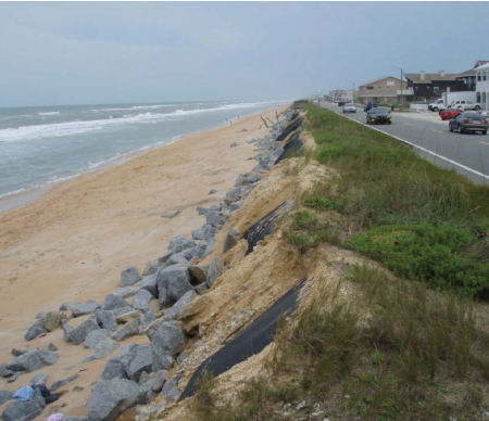
FIGURE 3-1 An eroding beach adjacent to State Road A1A in Flagler County, Florida, recently under study by the USACE for additional hurricane and storm damage risk reduction.
SOURCE: USACE (2014).
percent of New Jersey’s coastline are protected by a USACE storm damage reduction project (C. Bronson, USACE, personal communication, 2013).
The results of a telephone survey of coastal managers conducted by a group of researchers in South Carolina offer evidence that many states use strategies to reduce the consequences of a coastal storm, such as hazard zoning, building elevation, land purchase, or setbacks (see Table 3-1; London et al., 2009). Most of these measures attempt to discourage development in undeveloped, hazard-prone areas or encourage people to abandon their use. The strategies reportedly used by the most states were building elevation requirements, fixed setbacks, and land purchase, with only a few states reporting utility-line limits, abandonment, low-density development, relocation, or rolling setbacks. Not including building elevation, nonstructural strategies were generally viewed as difficult or somewhat
TABLE 3-1 Percentage of Coastal States Using Consequence Reduction Strategies, by Region
| Modification of Development Tools | All East and Gulf States (18 states) | Northeast (5 states) | Mid-Atlantic (5 states) | Southeast (4 states) | Gulf of Mexico (4 states) |
| Building elevation | 89 | 100 | 80 | 100 | 75 |
| Fixed setback | 83 | 100 | 100 | 75 | 50 |
| Land purchase | 78 | 100 | 100 | 50 | 50 |
| Hazard zoning | 72 | 100 | 80 | 25 | 75 |
| Hazard reconstruction limits | 61 | 60 | 60 | 100 | 25 |
| Rolling setback | 39 | 60 | 40 | 25 | 25 |
| Relocation | 39 | 40 | 20 | 50 | 50 |
| Low-density development | 33 | 60 | 20 | 50 | 0 |
| Abandonment | 33 | 60 | 20 | 25 | 25 |
| Utility/service-line limits | 28 | 40 | 0 | 25 | 50 |
NOTE: States were divided as follows: Northeast (Maine, New Hampshire, Massachusetts, Rhode Island, Connecticut), Mid-Atlantic (New York, New Jersey, Delaware, Maryland, Virginia), Southeast (North Carolina, South Carolina, Georgia, Florida [both East and Gulf coasts]), Gulf of Mexico (Texas, Louisiana, Mississippi, Alabama).
SOURCE: Adapted, with permission, from London et al. (2009).
difficult to implement (Table 3-2; London et al., 2009). Nonstructural strategies were given significantly lower scores by the responding states for ease of implementation compared with either beach nourishment and vegetation strategies (“soft stabilization”) or hard structural strategies.
Natural and nature-based approaches to coastal risk reduction include using or expanding dunes, salt marsh, mangroves, reefs, and seagrass to mitigate flooding and erosion associated with wave action or storm surge. The role of intact or restored ecosystems in providing for flood defense and enhancing resiliency to natural disasters along the East and Gulf Coasts has received substantial attention over the last decade and is an area of active research (e.g., Arkema et al., 2013; Duarte et al., 2013; Renaud et al., 2013; Temmerman et al., 2013). In contrast to heavily engineered structures, nature-based initiatives may have ecosystem benefits that extend beyond mitigation of coastal risk, including improved water quality, provision of fisheries habitat, and nutrient sequestration. Moreover, unlike engineered structures, biogenic habitats may have some potential for vertical accretion (e.g., oysters; Rodriguez et al., 2014), which could mitigate effects of sealevel rise (Lenihan, 1999). Living structures can also adapt to sea-level rise by shifting inland, in contrast to permanently emplaced hard structures. Of the 142 USACE projects listed in Appendix B, only 4 include natural
TABLE 3-2 Reported Ease of Implementation of Coastal Risk Reduction Strategies by Region (1= difficult, 4 = easy)
| Northeast (5 states) | Mid-Atlantic (5 states) | Southeast (4 states) | Gulf of Mexico (4 states) | |
| Hazard Reduction Measures: Hard structures | ||||
|
Seawall |
1 (difficult) | 1.2 | 1.62 | 0.75 |
|
Bulkhead |
1.25 | 1.8 | 1.88 | 1.75 |
|
Jetty |
1.25 | 1.6 | 2.88 | 1 |
|
Revetment |
1.25 | 2.2 | 2.62 | 1.5 |
|
Groin |
1 | 1.6 | 3 | 1.25 |
| Hazard reduction measures: Nature-based strategies | ||||
|
Beach nourishment |
3.25 | 3.2 | 2.75 | 1 |
|
Bulldozing/scraping |
2 | 2.8 | 1.25 | 2 |
|
Dune addition |
3 | 2 | 3.5 | 1 |
|
Vegetation |
3.25 | 3.8 | 4 (easy) | 1.67 |
| Consequence reduction measures: Building design and nonstructural land-use strategies | ||||
|
Building elevation |
3.12 | 2.3 | 1.75 | 1 |
|
Fixed setback |
1.75 | 1.4 | 1.5 | 0.75 |
|
Land purchase |
0.75 | 1.4 | 1 | 1 |
|
Hazard zoning |
1.25 | 0.6 | 0.75 | 0.75 |
|
Hazard reconstruction limits |
0.75 | 1.4 | 1.25 | 1 |
|
Rolling setback |
0.25 | 0.6 | 0.75 | 0.5 |
|
Relocation |
1 | 0.2 | 1 | 0.5 |
|
Low-density development |
1.25 | 0.4 | 0.5 | 0.25 |
|
Abandonment |
0.75 | 0.2 | 0.75 | 0.25 |
|
Utility/service-line limits |
0.25 | 0.6 | 0 | 0.25 |
SOURCE: Adapted, with permission, from London et al. (2009). Note that any value below 1 indicates that at least one respondent answered “not applicable,” which was scored with a 0. Respondents were the same states listed in Table 3-1.
systems as an explicit focus of the coastal risk reduction project (termed “ecosystem restoration” in Appendix B).
Louisiana’s Comprehensive Master Plan for a Sustainable Coast (CPRA LA, 2012) and the Mississippi Coastal Improvements Program (USACE, 2009) both endorse the “multiple lines of defense” concept, which utilizes a combination of nature-based approaches and hard structures to maximize storm surge risk reduction. As depicted in Figure 3-2, barrier islands shelter the coast from storm waves, and wetlands offer storm surge and wave attenuation, reducing the storm surge and wave heights against landward hardened structures. The effectiveness of each “line” in this defense system and how they work together to provide risk reduction is a subject of active research.
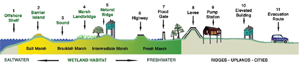
FIGURE 3-2 Various components of the multiple lines of defense approach for Louisiana.
SOURCE: Reprinted, with permission, from Pontchartrain Basin Foundation. Available online at www.mlods.org.
Historically, there has been little emphasis placed on risk reduction measures for large urban areas along the coasts. However, the widespread flooding and loss of life in New Orleans due to Hurricane Katrina in 2005 and the extensive damage throughout New York City from Hurricane Sandy in 2012 demonstrate the impacts for metropolitan areas that are not adequately protected against storm surge and wave attack. Aerts et al. (2014) estimate that without risk reduction measures in place, New York City could have annual flood losses averaging $174 million per year.
PERFORMANCE OF CONVENTIONAL HARD STRUCTURES FOR COASTAL HAZARD REDUCTION
The most commonly deployed hard structures to address coastal flooding are shore-parallel walls (e.g., seawalls, revetments, bulkheads) that are designed for deployment where there is high wave energy, and levees (dikes) and floodwalls are usually employed against flooding in the absence of significant wave action. Storm surge barriers are also used across river mouths or inlets to keep surge from propagating up rivers and estuaries (see Chapter 1). Other structures deployed to prevent coastal erosion, such as offshore breakwaters, do not provide significant risk reduction from storm surges, but are used to reduce loss of sediment from the beach and to reduce storm-induced erosion of protective dunes and levees. Of the 144 USACE coastal storm damage reduction projects listed in Appendix A, approximately half include hard structures of some form.
Seawalls and Shore-Parallel Structures
Seawalls and other shore-parallel structures (such as revetments and bulkheads; Figure 3-3) are built to reduce coastal risks to infrastructure where the natural beaches and dunes have been eliminated or significantly restricted and where other risk reduction options are prevented by lack of space or sediment. These hard structures are also intended to hold the shoreline position by reducing wave attack, storm surge, and associated erosion of landward areas. Although all shore-parallel structures absorb wave energy, different structure types are designed for different coastal settings (see Figure 3-3). Given this report’s focus on reducing risk associated with hurricane storm surge, this section focuses on seawalls.
Overall Effectiveness for Reducing Flood Damage
Seawalls have a long history of being used to prevent flood damage and casualties during severe coastal storms, and the Galveston Seawall is one the earliest examples (Wiegel and Saville, 1996). Galveston, Texas, was
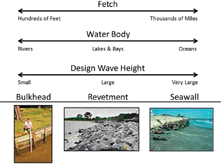
FIGURE 3-3 Types of shore-parallel structural risk reduction strategies.
SOURCE: Douglass and Krolak (2008).
devastated by a Category 4 hurricane that made landfall on September 4, 1900, killing more than 6,000 inhabitants and causing more than $111 billion (2013 dollars) in damage (Blake et al., 2011). It remains the deadliest natural disaster in U.S. history. The original seawall was completed in 1904, with several subsequent extensions; the present length is 10.6 mi (17 km), more than three times the original length. The seawall has protected the city from 13 hurricanes (Kraus and Lin, 2009). The 1915 hurricane, for example, was considered as severe as the 1900 event and had a particularly long duration. The city still saw similar economic damage (Pielke et al., 2008, and the seawall itself sustained major damage. A total of 11 people died; the reduction in fatalities compared with the 1900 hurricane is often credited to the existence of the seawall (Davis, 1961). Minor wave overtopping occurred during Hurricane Ike in 2008, and Kraus and Lin (2009) report that bayside flooding, as opposed to ocean-side flooding over the seawall, led to inundation in the city. Areas without dunes or seawalls were heavily damaged or destroyed.
During field observations to quantify damage after Hurricane Sandy, Irish et al. (2013) reported that a buried relic seawall lessened the hurricane’s impact relative to adjacent areas (Figure 3-4). They found that pre-storm beach and dune profiles were similar between two neighboring boroughs (Bay Head and Mantoloking), but that a 0.75-mile-long (1.2-km) stone seawall constructed in 1882 lay buried below the Bay Head dune. Field observations showed that water levels in the two communities were similar, but the number of homes that were damaged or destroyed was significantly higher in the community without the seawall. Through numerical modeling, they estimated that the existence of the seawall, although not capable of preventing overtopping, decreased wave forces by a factor of two. Other factors, such as differences in the width of the barrier island and proximity to existing or former inlets, may have also contributed to the contrasts between boroughs.
Economic Costs and Documented Returns to Date
Data are sparse on the documented economic benefits of seawalls or other shore-parallel structures. In 1904, the originally specified length of the
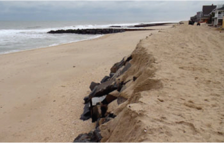
FIGURE 3-4 Relic seawall in Bay Head, New Jersey, that was buried beneath a dune and uncovered during Hurricane Sandy.
SOURCE: Photo courtesy of Jennifer Irish. Available online at http://www.nsf.gov/news/news_images.jsp?cntn_id=128545&org=NSF.
Galveston Seawall was completed at a cost of $1.6 million (approximately $40 million in 2013 dollars) (USACE, 1981). The seawall protected the city not only against the unnamed hurricane in 1915, but also against Hurricane Carla in 1961 (Davis, 1961) and Hurricane Alicia in 1983. If the seawall had not been in place, another $234 million (2013 dollars) in damage could have occurred from the 1983 storm alone (K. Bohnam, USACE quoted in Associated Press, 1984).
Linham et al. (2010) reported that the cost of a vertical seawall ranges from $0.6 million/mile ($0.4 million/km) to $44 million/mile ($27 million/ km), with price affected by factors including the design height, anticipated wave loadings, and construction materials. The UK Environment Agency (2007) reported average costs of $4.3 million/mile ($2.7 million/km) (in 2013 dollars).
Impacts on Adjacent Areas
The impact of seawalls on adjacent areas is a many-decades-old debate; reviews include Kraus (1988), Pilkey and Wright (1988), and Kraus and McDougal (1996). Possible adverse effects include offshore steepening of the beach profile, intensified local scour at the toe or end of the seawall, transport of sand to a substantial distance offshore, downdrift erosion, and delayed post-storm recovery (Dean, 1986). Other possible adverse effects include reduction of the beach width fronting the seawall and acceleration of the beach erosion rate (Basco, 2006). Kraus and McDougal (1996) note that because seawalls are often built in areas with chronic beach erosion, passive versus active erosive forces need to be distinguished. Passive erosion refers to “tendencies which existed before the wall was in place” (Griggs et al., 1991, 1994) and active erosion refers to the “interaction of the wall with local coastal processes” (Kraus and McDougal, 1996). Dean (1986) provides an assessment of commonly expressed concerns relating to coastal armoring (Table 3-3).
Coastal armoring is generally used in areas that are already experiencing erosion. According to Dean (1986), it is likely that coastal armoring will cause an increase in erosion on adjacent unprotected beaches because hard structures prevent the protected beach from providing sediment to the rest of the coastal system. Eroding beaches will continue to erode, while the structures prevent the progressive landward movement of the protected shoreline. However, Dean (1986) concludes that there are no observations or physical arguments to support the concern that coastal armoring causes accelerated erosion seaward of a protected beach, causes the beach profile to steepen dramatically, or delays post-storm recovery.
TABLE 3-3 Assessment of Some Commonly Expressed Concerns Related to Coastal Armoring
| Concern | Assessment | |
| Coastal armoring placed in an area of existing erosional stress causes increased erosional stress on the beaches adjacent to the armoring. | True | By preventing the upland from eroding, the beaches adjacent to the armoring share a greater portion of the same total erosional stress. |
| Coastal armoring placed in an area of existing erosional stress will cause the beaches fronting the armoring to diminish. | True | Coastal armoring is designed to protect the upland, but does not prevent erosion of the beach profile seaward of the armoring. Thus an eroding beach will continue to erode. If the armoring had not been placed, the width of the beach would have remained approximately the same, but with increasing time, would have been located progressively landward. |
| Coastal armoring causes an acceleration of beach erosion seaward of the armoring. | Probably False | No known data or physical arguments support this concern. |
| An isolated coastal armoring can accelerate downdrift erosion. | True | If an isolated structure is armored on an eroding beach, the structure will eventually protrude into the active beach zone and will act to some degree as a groin, interrupting longshore sediment transport and thereby causing downdrift erosion. |
| Coastal armoring results in a greatly delayed post-storm recovery. | Probably False | No known data or physical arguments support this concern. |
| Coastal armoring causes the beach profile to steepen dramatically. | Probably False | No known data or physical arguments support this concern. |
| Coastal armoring placed well back from a stable beach is detrimental to the beach and serves no useful purpose. | False | In order to have any substantial effects on the beaches, the armoring must be acted upon by the waves and beaches. Moreover, armoring set well-back from the normally active shore zone can provide “insurance” for upland structures against storms. |
SOURCE: Dean (1986).
Environmental Impacts
Hydrodynamic and morphologic response of a beach to a wall and the ecological effects depend on the position of the wall on the beach relative to breaking waves and swash, with fewer impacts the farther landward the wall is from the shoreline (Weggel, 1988; Plant and Griggs, 1992; Hearon et al., 1996; Dugan and Hubbard, 2006; Dugan et al., 2008). Habitat losses in front of the walls increase as the beach narrows over time because sediment moves out of the area and cannot be replaced by erosion of the protected land (Dugan and Hubbard, 2006; Dugan et al., 2008). The high intertidal zone that is most strongly altered by a newly placed wall can be a key location for spawning habitat for several species of fish and horseshoe crabs; the same areas may be critical for foraging predators (Dugan et al., 2008; Jackson et al., 2008).
Species abundance and diversity, for both invertebrates and shorebirds, can be significantly lower along fronting walls (Dugan et al., 2008; Sobocinski et al., 2010). As the system evolves, the entire intertidal zone of the beach can be eventually eliminated, leaving only subtidal habitat and an intertidal zone composed of construction materials such as wood, boulders, or concrete (Nordstrom, in press). The wall itself can still provide habitat, but can decrease the area of intertidal habitat, reduce the capability of many fauna in settling on it, limit the distribution of specific species, and place species that would live at different positions in the intertidal gradient closer to each other (Bulleri and Chapman, 2010; Chapman and Underwood, 2011). These habitats favor spread of introduced and invasive species.
New structures with relatively homogeneous surfaces lack the crevices, small fractures, pits, and holes that can occur on natural rocks or on structures that have been in place for a long time and have undergone weathering (Moschella et al., 2005). Benthic communities on human structures become more similar to natural rock with increasing age, although communities in these two types of habitat can remain distinct after several decades (Moschella et al., 2005; Burt et al., 2011). In a limited number of studies, structures with surface complexity (rough or pitted rather than smooth and flat) have been associated with increased species diversity (Moschella et al., 2005; Chapman and Underwood, 2011).
Structures can be built or modified to retain, restore, or add natural, semi-natural, or artificial landforms and habitats (Moschella et al., 2005; Browne and Chapman, 2011; Chapman and Underwood, 2011; Nordstrom, in press). Larger structures can be altered to enhance habitat by providing low-angle slopes and greater surface complexity (Chapman and Underwood, 2011)—for example, building rip-rap revetments rather than vertical walls. Great potential exists for altering designs to reduce hard structures’ environmental impacts and enhance habitat value, but more
research is required to achieve the most desirable assemblage for a given region (Chapman and Underwood, 2011).
Increased shoreline hardening within estuaries is a serious environmental concern. In Mobile Bay, coastal armoring has increased by approximately 0.5 percent per year since 1955 (Douglass and Pickel, 1999) with approximately 38 percent of the shorelines protected by bulkhead or riprap (Jones et al., 2009). A similar pattern has been documented for Chesapeake Bay (Bilkovic and Roggero, 2008). The loss of coastal vegetation decreases the nursery value of nearshore areas (Bilkovic and Roggero, 2008), and also affects nutrient regulation and denitrification. Enhanced scour at the base of seawalls can deepen the sediment base and result in lower photosynthesis, further reducing the ecological value of shallow estuarine waters.
Levees and Floodwalls
Unlike seawalls, coastal levees in the United States are generally not designed to resist the direct attack of high-energy waves. Instead, levees are often located landward of large areas of salt marsh that dissipate wave energy or along rivers or waterways inland from the coast to reducing flooding associated with coastal storm surge. In the Netherlands, large coastal levees with concrete revetment blocks or asphalt cover have been built directly along the coast to prevent flooding and wave attack associated with storm surge. To prevent landward flooding, levees either extend all the way around the land to be protected or are tied into higher upland that prevents inundation from other sides.
Floodwalls (Figure 1-7) are used in areas where there is insufficient land for the large footprint of levees. They need to be stable enough to withstand an overtopping storm surge, including the scour that can occur on the upland side of the floodwall after overtopping.
Overall Effectiveness for Reducing Flood Damage
Coastal levees can be very effective at protecting homes and other infrastructure if appropriately designed for the anticipated water levels. After Hurricane Katrina, Congress authorized and funded the Hurricane and Storm Damage Risk Reduction System (HSDRRS) to reduce risks of storm surge from a 1 percent annual-chance (100-year) event for greater New Orleans and parts of southeast Louisiana. The $14.4 billion project includes 350 miles (560 km) of levees and floodwalls, 73 pumping stations, 3 canal closure structures with pumps, and 4 gated outlets. The HSDRRS was tested for the first time in August 2012 for surge protection from Hurricane Isaac, and the USACE reported that the entire HSDRRS operated as designed (USACE, 2013c).
There have, however, been notable coastal levee failures. During Hurricane Katrina, a combination of waves and surge overtopped the Mississippi Gulf River Outlet levee, leading to major levee breaching and flooding of the Lower Ninth Ward and St. Bernard Parish. Floodwalls in several parts of New Orleans also failed for a variety of geotechnical reasons at levels below the project design, flooding large swaths of the city (IPET, 2007).
Economic Costs and Documented Returns to Date
Planning-level cost information for a coastal levee designed for a 1 percent chance (100-year) event is reported by USACE (2013f) as $8.4 million/mile ($5.2 million/km) for the total estimated first construction cost. The total estimated first construction costs for a floodwall designed for a 1 percent chance event was $28 million/mile ($17 million/km). However, because coastal levees and floodwalls can be designed to withstand varying degrees of storm surge and wave attack, costs will vary widely with design specifications. Although operations and maintenance costs nationwide have not been compiled, RAND Corp. (2012) reported that several New Orleans levee districts will incur approximately $3 million to $5 million/year in operations and maintenance costs for their portions of the HSDRRS, and for the Orleans Levee District will approach $20 million/year. The committee was unable to find publicly available information on economic returns from coastal levee projects based on actual storm events.
Impacts on Adjacent Areas
Large-scale levee construction changes the hydrodynamics of an estuarine system and can decrease the accommodation space for floodwaters, increasing the likelihood of flooding in adjacent areas that lack the levee’s protection. Increased water levels in unprotected communities could have significant and immediate economic and life-safety impacts. There are varying levels of impact. While the New Orleans HDSRRS provided protection for areas within the system during Hurricane Isaac, some low-lying communities outside the system experienced devastating storm surge and rainfall flooding (USACE, 2013c), which led to public concern that the HDSRRS increased the amount of flooding to areas beyond it. In an assessment of the HDSRRS’s performance during Hurricane Isaac, the USACE found that water-level changes outside the system that could have been due to construction of the HDSRRS were 0.4 ft (0.12 m) or less (USACE, 2013c). However, a proposed project that was meant to keep water from entering Lake Pontchartrain, Louisiana, via levees and gates was shown (through models) to increase storm surge levels along the Mississippi coast by up to 3 ft (0.9 m) (Ben C. Gerwick, Inc., 2012). Adverse impacts on adjacent
unprotected areas can be minimized by using smaller ring levees to protect only the most critical human infrastructure.
Environmental Impacts
Levees fundamentally change flow conditions above and below the structure. Even when water is allowed to flow through gates in levees, salinity values and the flux of nutrients can be modified to a point that entirely different biological communities develop on either side of the structure and fish migration patterns are altered. Construction of new levees without provision for natural water exchange results in the elimination of wetlands. Levees also prevent the delivery of waterborne sediment to formerly inundated areas, contributing to subsidence and reducing the potential to keep pace with sea level rise.
Levees in the coastal environment have little direct environmental value, but there is increasing interest in modifying the design of coastal risk reduction features to increase ecological functions and reduce the overall impacts (Day et al., 2000). The “rich levee” concept (Dijkman, 2007) proposes to increase biodiversity within wide coastal levees (as used in the Netherlands) by providing diverse habitats within the structural design, including vegetated shore-parallel ridges and carefully selected armoring material that could provide habitat for diverse flora and fauna.
Storm Surge Barriers
Overall Effectiveness for Reducing Flood Damage
There are only a few storm surge barriers in the United States, although major systems installed abroad demonstrate their efficacy. The Eastern Scheldt barrier in the Netherlands (completed in 1986) and the Thames barrier in the United Kingdom (completed in 1982) have prevented major flooding. Lavery and Donovan (2005) note that the Thames barrier, part of a flood risk reduction system of barriers, floodgates, floodwalls, and embankments, has reliably protected the City of London from North Sea storm surge since its completion.
Four storm surge barriers were constructed by the USACE in New England in the 1960s (Fox Point, Stamford, New Bedford, and Pawcatuck) and a fifth in 1986 in New London, Connecticut. The barriers were designed after a series of severe hurricanes struck New England in 1938, 1944, and 1954 (see Appendix B), which highlighted the vulnerability of the area. The 1938 hurricane damaged or destroyed 200,000 buildings and caused 600 fatalities (Morang, 2007; Pielke et al., 2008).
The 2,880-ft (878-m) Fox Point Barrier (Figure 1-8) stretches across
the Providence River, protecting downtown Providence, Rhode Island. The barrier successfully prevented a 2-ft (0.6-m) surge elevation (in excess of tide elevation) from Hurricane Gloria in 1985 and a 4-ft (1.2-m) surge from Hurricane Bob in 1991 (Morang, 2007) and was also used during Hurricane Sandy. The New Bedford, Massachusetts, Hurricane Barrier consists of a 4,500-ft-long (1372-m) earthen levee with a stone cap to an elevation of 20 ft (6 m), with a 150-ft-wide (46-m) gate for navigation. The barrier was reportedly effective during Hurricane Bob (1991), an unnamed coastal storm in 1997 (Morang, 2007), and Hurricane Sandy. During Hurricane Sandy, the peak total height of water (tide plus storm surge) was 6.8 feet (2.1 m), similar to the levels reached in 1991 and 1997. The Stamford, Connecticut, Hurricane Barrier has experienced six storms producing a surge of 9.0 ft (2.7 m) or higher between its completion (1969) and Hurricane Sandy. During Hurricane Sandy, the barrier experienced a storm surge of 11.1 ft (3.4 m), exceeding that of the 1938 hurricane (USACE, 2012).
Economic Costs and Documented Returns to Date
The cost and maintenance requirements of storm surge barriers are likely to limit them to intensively developed areas, where they are or would be key elements in risk reduction strategies (Jiabi et al., 2013; Walsh and Miskewitz, 2013). The committee was able to obtain data on the construction costs and estimated economic returns of three USACE storm surge barriers. The Stamford Hurricane Barrier was completed in 1969 at a cost of $14.5 million (approximately $100 million in 2013 dollars).3 The USACE estimates that the project has prevented $96 million (2013 dollars) in flood and coastal storm damages, as of September 2013. Construction of the New Bedford Hurricane Barrier was completed in 1966 at a cost of $18.6 million (approximately $140 million in 2013 dollars).4 The USACE estimates that $52 million (2013 dollars) in flood damage was prevented due to the operation of the hurricane barrier through September 2013. The Fox Point Hurricane Barrier was completed in 1966 at a cost of $15 million (approximately $110 million in 2013 dollars),5 and the USACE estimates that $5.8 million (2013 dollars) in damages has been prevented by the project through 2013 (N. Frankel, USACE, personal communication,
______________
3See http://www.nae.usace.army.mil/Missions/CivilWorks/FloodRiskManagement/Connecticut/StamfordHurricaneBarrier.aspx. Note that inflation adjustments for the projects listed here were based on the midpoint of the construction period.
4See http://www.nae.usace.army.mil/Missions/CivilWorks/FloodRiskManagement/Massachusetts/NewBedford.aspx.
5See http://www.nae.usace.army.mil/Missions/CivilWorks/FloodRiskManagement/RhodeIsland/FoxPoint.aspx.
2014). Note that maintenance costs are not reflected in the above costs and could represent major additional costs over the life span of these projects.
Impacts on Adjacent Areas
As with large levee projects (discussed in the section above), storm surge barriers can affect the hydrodynamics of the surrounding areas. For example, the slowdown in current velocities via floodgates or storm surge barriers will reduce the sediment transport potential and channel-scouring ability of the currents, leading to increased deposition rates in some parts of the basins and decreased deposition in the tidal delta (Saeijs and Geurts van Kessel, 2005). Eelkema et al. (2013) observed an increase in wave-driven features and a steady erosive trend in the Eastern Scheldt delta in the Netherlands after construction of the storm surge barrier.
Environmental Impacts
Gates and barriers restrict the evolution of coastal-dependent species, because they reduce the effect of ocean or estuarine processes along tidal channels. Restrictions to flooding by saline waters limit the spatial distribution of coastal species, and species that depend on extreme flood events to prevent the proliferation of competitors and predators are likely to be adversely affected by gate closures. Reduction of tidal amplitude due to the Eastern Scheldt barrier has decreased the amount of saltwater marshes and caused shoaling of tidal creeks within the estuary (Saeijs and Geurts van Kessel, 2005). The number of floodgate closures due to sea-level rise is likely to increase dramatically in the future (Carbognin et al., 2010), potentially increasing adverse effects on coastal habitats.
PERFORMANCE OF NATURAL AND NATURE-BASED APPROACHES
Natural landforms and habitats provide a first line of defense in reducing the risk of wave damage, overwash, and flooding in the coastal zone. They can also have positive effects as part of coastal risk reduction projects, assuming that there is enough space for a sufficiently functional natural system between the coastal hazard and the area to be protected. Truly natural landforms are most likely to effectively provide risk reduction when used in concert with nonstructural land-use approaches or for portions of the shoreline dedicated to conservation or restoration, because the inherent dynamism of natural processes (see Box 3-1) does not provide a stable system. If landform stability is required, natural landforms will need to be augmented to reduce their mobility and susceptibility to overwash through
BOX 3-1
Role of Natural Dynamism in the Context of Coastal Risk
Beaches are wave-built and thus do not provide barriers at an elevation that restricts overwash or surge during severe storms. Instead, the natural flood prevention function is provided by sand dunes, an integral component of natural sandy shore systems that are linked to the beach in cycles of sediment exchange. Sediment moves from the dune to the beach through erosion by storm waves, followed by the gradual delivery of sand from the beach to the dune by wind action and swash processes. This sediment exchange is a sign that the beach and dune are functioning naturally, and the dune is at the proper location, given the sediment budget and wave and wind climate. Under natural conditions, dunes are inherently dynamic, and the risk reduction they provide against overwash and flooding varies spatially and temporally, with periods of overwash alternating with periods of dune building that provide temporary stability. There is diversity among the dune systems of the East and Gulf Coasts. In some areas along the Gulf of Mexico, dunes are neither high nor extensive, which is thought to be due to reduced winds and high sand moisture.
The overwash process delivers sediment to the bayshore of barrier islands, allowing them to migrate landward through time while maintaining sediment volume. Overwash that does not reach the back bay builds up the height of the barrier islands, allowing them to keep pace with sea-level rise. Inlets are periodically created across low portions of the barrier islands, migrate alongshore, and may close naturally due to delivery of sediment from updrift. While open, inlets deliver sediment inland, creating flood tidal deltas and providing sediment for bay beaches and salt marsh to form back-barrier habitat. Natural dynamism thus is not a threat to maintenance of barrier islands and spits under natural conditions; however, it is a threat to human facilities with a fixed position on inherently mobile landforms.
The rate of change in natural environments could increase in the future from high rates of sea-level rise or from lessening sediment supply. This could lead to less or even no protective benefits during storms—for example, through barrier island breakup or complete submergence (“drowning in place”) (McBride et al., 1995; FitzGerald et al., 2008).
time. These “nature-based” approaches primarily include beach nourishment; dune building; and conservation, creation, or restoration of salt marsh, seagrass, mangroves, and oyster and coral reefs. The sections below focus mostly on these human-modified nature-based systems and their role in coastal risk reduction rather than on truly natural approaches, although these are mentioned where appropriate. As discussed in the sections below, a nature-based system does not necessarily have the same environmental properties as its natural counterparts. They may also have impacts—both positive and negative—on other uses of the coast, such as navigation, ecosystems and fisheries, and recreation and tourism.
Understanding the geological setting and/or human use of a project area is critical to evaluating hazard-related problems and suitable solutions. Although coastal flooding is an issue on both the high-relief coasts of Maine and Massachusetts and the barrier island coasts along much of the East and Gulf Coasts, the solutions may be different. Geological structure affects topography, shoreline orientation, sediment erodibility, and the location, volume, and grain-size characteristics of sediment delivered to the coast, which, in turn, create distinctive natural environments. Past human uses are important because they reflect the historical context and present levels of development, and these legacy effects determine both the suitability of mitigating measures and the size and cost of implementation. Additionally, matching coastal risk reduction strategies to the geological setting preserves the habitat while minimizing disruptions to traditional recreational and economic use of the land. For example, placing gravel on a sandy barrier would disrupt traditional use of a coast with significant beach tourism.
Beach Nourishment and Dune Building
Beaches, when combined with sand dunes, reduce the risks of storm surge–related wave attack and flooding on barrier islands and the mainland. Natural beaches can be widened and dunes enlarged through beach nourishment projects to reduce coastal storm risks for developed areas, although such actions come with both benefits and costs. Beach nourishment and dune building are currently significant parts of the USACE’s strategy for coastal risk reduction (see Figure 1-9); thus, the committee focused substantial attention on discussion of these options and their environmental benefits and adverse impacts.
Overall Effectiveness for Reducing Flood Damage
Beach nourishment projects provide fill sediment to counteract and/or repair erosion while increasing the distance of coastal infrastructure from the surf and swash zones and providing space and a source of sand that favor formation and protection of dunes. The coastal risk reduction value of dunes is in their height and volume. The height of the crest determines its value as a barrier against wave attack and flooding, while a sufficient sediment volume allows dunes to survive wave erosion during storms, maintaining the integrity of the crest. Naturally evolving dunes are often too low, narrow, mobile, or discontinuous to protect immediately landward infrastructure, and so they are often augmented by stabilizing them and increasing their height and volume through emplacement of sand-trapping fences or vegetation or by depositing sediment in fill operations.
It is often difficult to separate the amount of risk reduction provided
against storm surge and wave attack caused by the extra width of a nourished beach from the effects of the dune superimposed on it. Post-storm damage surveys in New Jersey, North Carolina, and South Carolina reveal that together, increased beach width and dunes reduce flooding and storm damage (Houston, 1996a). The nor’easter storm of March 1962 in New Jersey caused extensive overtopping and elimination of dunes along many communities, but not in areas where property owners had implemented programs to build up dunes (USACE, 1962, 1963). Pre- and post-storm surveys following Hurricane Sandy in New Jersey in 2012 revealed that both beach width and dune height were critical in preventing breaches and overwash, even in locations that were not nourished (Coastal Research Center, 2013). A well-maintained dune in Seaside Park survived the storm, while dunes in nearby municipalities that did not have aggressive dune-building programs suffered overwash, leading to the loss of many homes.
Hurricane Hugo in South Carolina in 1989 revealed the value of high, wide dunes. Post-storm surveys at Myrtle Beach revealed less storm surge penetration and damage to structures behind the widened beach and enlarged dunes than adjacent areas. Homes landward of large dunes received little damage directly from waves and water levels, while low dunes were removed down to the planar beach level. Dunes up to 23-ft (7-m) high and 50ft (15-m) wide were cut back by waves but maintained their integrity (Stauble et al., 1991). All dunes less than 50-ft (15 m) wide were completely eroded (Thieler and Young, 1991), and nine breaches occurred in barrier islands and spits in places where dunes were small or nonexistent (Stauble et al., 1991).
The value of beach fill and dune building in protecting against moderate-energy hurricanes was dramatically revealed in North Carolina as a result of Hurricanes Bertha and Fran in 1996 and Dennis and Floyd in 1999. Hurricanes Dennis and Floyd caused no damage to buildings behind three USACE-constructed dune projects, but damaged or destroyed over 900 buildings located outside the project dunes (Rogers, 2007). Federal Insurance Administration claims for damage caused by storm surge and wave attack and overwash resulting from Hurricanes Bertha and Fran revealed far less damage to structures in locations protected by USACE beach nourishment projects than in adjacent unprotected locations (USACE, 2000a).
The impact of a storm on beaches, dunes, and the upland depends on both storm severity and landform characteristics. Regional distinctions in beach and dune characteristics result in different susceptibility to overwash and flooding, even under the same storm wave and surge characteristics (Sallenger, 2000). Building dunes to increase levels of risk reduction over natural levels may require different standards depending on the region, although the general concepts remain the same. Small dunes are readily eroded and overtopped and are not effective in preventing landward flood-
ing, regardless of the region in which they occur. Beach nourishment and dune construction are not generally well-suited for application to most major urban centers or areas with large port and harbor facilities because of the space requirements and the level of risk reduction desired.
Beaches and dunes on the ocean shore protect against water levels and waves coming from that side, but they do not prevent back-bay flooding from water that passes through coastal inlets and bay mouths (USACE, 2000b). The problem of bayside flooding and the inability of existing coastal risk reduction projects to prevent it were dramatically demonstrated during Hurricane Sandy in New Jersey and New York in October 2012 (USACE, 2013d). Dunes constructed on barrier islands, however, could reduce the possibility for overwash or breaching, potentially lessening the likelihood of bay flooding.
Economic Costs and Documented Returns
The costs of beach nourishment and dune building depend upon the size and location; methods of borrow, transport, and placement of materials; estimated renourishment requirements; and ultimately, how the coast evolves. The level of risk reduction afforded by a beach nourishment project also varies over time, as the beach and dune are eroded by natural processes, requiring periodic renourishment (varying by location). USACE (2013f) reports the costs of beach restoration that reduces the risk of flooding to 1 percent annual chance as $18 million/mile ($11 million/km), with renourishment costs of $6.3 million/mile ($3.9 million/km). However, many beach nourishment projects are not designed to this level and might therefore be constructed at lower costs.
A general case for the economic value of beach nourishment and dune-building projects can be made by noting the great economic costs of losses due to coastal storms and the documented reduced damages behind enhanced dunes discussed in the preceding section (USACE, 1962, 1963, 2000b, 2013d; Stauble et al., 1991; Houston, 1996a; Coastal Research Center, 2013; Rogers, 2007). However, reliable economic data to quantify the benefits of these projects are lacking. Reported damages associated with past hurricanes (see Appendix A) provide a sense of the potential economic benefits if coastal storm damage reduction projects could significantly reduce damages.
The economic benefits of beach nourishment extend well beyond coastal risk reduction. Houston (2013) estimates that about half of Florida tourists are beach tourists, who in 2012 spent about $36 billion directly (including $12.6 billion from international tourists), including more than $6 billion in local, state, and federal taxes. A wider beach supports more business to the beach communities and subsequent community growth
(Jones and Mangun, 2001; Houston, 2013). Finkl (1996) argues that adding the economic returns of beach nourishment projects for tourism to returns for coastal risk reduction makes a compelling case for nourishment as an economic investment.
Viewpoints of the value of beach nourishment depend on whether the observer has primary interest in damage reduction, perceived retention or enhancement of property values, recreation, or environmental benefits (Camfield, 1993; Nordstrom, 2005). Debate occurs on some of the differences in viewpoints (e.g., Houston, 1991; Pilkey, 1992), especially cost-effectiveness.
Impacts on Adjacent Areas
Nourished sand is subject to the same erosional pressures as the original beach, and can move onshore, offshore, or alongshore. Sand transported alongshore moves to downdrift beaches or to an inlet or offshore shoal. Sedimentation in tidal channels at inlets as a consequence of beach renourishment can be considered a detrimental side effect of longshore transport. Most nourishment operations are designed to minimize longshore transport of fill (Beachler and Mann, 1996; Houston, 1996a; Bocamazo et al., 2011). Unwanted sedimentation is often addressed using terminal structures, which can be linked to sand bypass operations, which transfer sediments to eroding segments downdrift of stabilized inlets, or backpass operations, which recycle sediments back to eroding portions of the project area. Sand transported onshore as part of the overwash process is often put back onto the beach post-storm. This procedure hinders the natural migration of the beach, but preserves the sand at the nourished beach.
An increase in the sediment budget downdrift of fill areas enhances the likelihood for landforms to evolve, increasing topographic diversity in a way that is more natural than by direct nourishment. Movement of fill sediment from developed areas to adjacent natural areas helps create wider beaches and larger dunes in those areas and reduces the likelihood that undeveloped enclaves adjacent to coastal risk reduction projects will be weak links in regional plans.
Adverse Environmental Impacts
Many studies have been conducted on the environmental impacts of beach nourishment, but knowledge gaps still exist (Peterson and Bishop, 2005). Beach nourishment can have both positive and negative effects on environmental resources, but negative effects dominate in the short term. Sand placed on the beach during nourishment typically results in immediate mass mortality of sand-dwelling organisms (Peterson et al., 2006), and thus
loss of ecosystem function. Newly deposited sediments on beaches typically support similar populations of aquatic sediment-dwelling (infaunal) animals within 1 to 2 years after renourishment (Gorzelany and Nelson, 1978; Leewis et al., 2012), although a thorough investigation of recovery is hampered by issues related to the adequacy of post-nourishment monitoring and sampling designs (Peterson and Bishop, 2005). The long-term, cumulative ecological implications of repeated burial from large-scale nourishment projects are still unknown (Lindeman and Snyder, 1999; Posey and Alphin, 2002; Speybroeck et al., 2006). A critical strategy to reduce ecological impacts is to restrict the timing of dredge and fill operations to winter months, when impacts on biota are reduced. Conducting nourishment in winter may still allow spring-summer recruitment and colonization by infaunal invertebrates under certain conditions (Peterson et al., 2006).
The effects of substrate disturbance on subtidal organisms that use stable hard-bottom or low-energy conditions are largely unknown (Nelson, 1989, 1993), but hard-bottom fauna and flora (including corals and seagrasses) adjacent to sandy beaches may be adversely impacted by additional sedimentation or poor water quality from renourishment. These impacts can be significant, but detecting physical changes as a result of nourishment is difficult, given the background natural variability (Jordan et al., 2010).
Long-term ecological recovery is dependent on a number of factors, including sediment quality and quantity, the nourishment technique, and the size and place of the nourishment (Speybroeck et al., 2006). Use of sediment that differs from native materials (e.g., grain size and shape, compaction, shear resistance, moisture retention) can change the habitat characteristics and evolutionary trend of the beach (Jackson et al., 2002). The longest recovery times seem to be where the grain-size characteristics of the fill materials are poorly matched to the natural beach (Reilly and Bellis, 1983; Rakocinski et al., 1996; USACE, 2001). Alterations of sediment characteristics can influence nesting and hatching success of turtles (Crain et al., 1995; NRC, 1995). Sediment on the active foreshore can be quickly reworked to resemble native sediment, but sediment within the inactive fill area on the backshore will retain the characteristics it had when emplaced, which can delay faunal recovery (Schlacher et al., 2012). Placing poorly sorted sediment on the beach will lead to removal of sand by wind and leave a coarse shell or gravel lag surface that resists aeolian transport and restricts natural dune evolution (van der Wal, 1998; Marcomini and López, 2006; Jackson et al., 2010). Silts and clays increase turbidity during placement or when reworked from the fill during storms. Mismatched fine fill sediments can inhibit burrowing of species from all intertidal zones (Viola et al., in press), while sediment that is coarser or shellier than native sediment may have detrimental effects on recovery of the natural benthic invertebrate community and foraging habitat for other species, including
surf fishes and shore birds (Peterson et al., 2006, 2014; Van Tomme et al., 2012; Manning et al., 2013).
The scale of the project and the volume of sediment used also impact the extent of ecological effects. Although difficult to express quantitatively, in general, the more sediment placed between the active shoreline and human infrastructure, the greater the potential for new habitats to form and survive storm wave attack (Nordstrom et al., 2012). However, nourishing a beach at an elevation higher than a natural beach (Figure 3-5) often creates a vertical scarp that restricts movement of fauna and
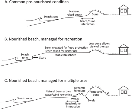
FIGURE 3-5 Beach nourishment scenarios for coastal risk reduction and implications for beach function. Nourishing a beach at the height of a natural berm (C) or even lower allows natural processes to form the final berm (Dean, 2002) and is more compatible with natural habitat requirements. The seaward portion of the fill area could be a dynamic natural zone dedicated to nonconsumptive human uses, while the landward portion could be composed of a relatively static protective dune. The volume of fill sediment would be the same in (B) and (C), but the implications for wildlife would differ greatly.
impedes natural reworking of the backshore by waves and wind (Jackson et al., 2010; Convertino et al., 2011). Large beach nourishment projects can have greater short-term adverse ecological impacts than projects that are small or introduce sediment at a slower rate (Bilodeau and Bourgeois, 2004; Schlacher et al., 2012). Some species depend on gradual recolonization of fill from the edges, and so shorter nourished beaches should recover more quickly, although strategies are available to mitigate these impacts, including slowing the rates of beach fill and leaving small areas unfilled to function as feeder sites for biota (FWS, 2002; Bishop et al., 2006; Schlacher et al., 2012). Many of these project modifications could reduce the impacts of beach nourishment on beach invertebrates, shorebirds, and surf fishes at greater costs per unit of sediment emplaced (Manning et al., 2013).
An important adverse environmental effect of building unnaturally high dunes on barrier islands is that by protecting against overwash, the dunes prevent natural accretion processes that help the island sustain itself. Barrier islands and spits are prevented from keeping pace with sea-level rise or from reestablishing now-rare dynamic habitats, such as washover fans that are favored environments for piping plovers (Maslo et al., 2011; Schupp et al., 2013; see Box 3-1).
The process of offshore sediment extraction to support beach nourishment projects also has important ecological impacts. Dredging of sand borrow areas can decrease organism abundance, total biomass, and the number and composition of species, as well as the average size of the dominant species (USACE, 2001; Brooks et al., 2006). Abundance of some benthic species may recover within a year; recovery of biomass and species diversity may occur within a year or somewhat longer, but changes in biomass composition may take longer. Long-lasting and deep borrow pits may attract a different biological community than occurred before and restricted water movement may create hypoxic or anoxic conditions (USACE, 2001). To reduce impacts, dredging can be restricted to winter months and small, unmined refuge patches can be left within borrow areas (Cutter et al., 2000; Minerals Management Service, 2001; Hobbs, 2002). However, only a small effort has been directed at assessing impacts on biological assemblages from sand removal, especially with respect to ecosystem function (Brooks et al., 2006; Michel et al., 2007). Likewise, long-term impacts have not been addressed.
Offshore borrow pits also have potentially important physical effects on wave regime. Using wave models, Kelley et al. (2001) show that borrow sites can impact the sediment transport regime at the shoreline if the borrow areas are nearshore, large, and deep. Repeated use of the same sediment source area, resulting in deeper offshore pits, would lead to a greater eventual impact on the shoreline. Because most offshore sites are far removed from active sediment sources, such as the nearshore zone and
river mouths, these sites are not likely to be refilled with sand by natural processes, resulting in a permanent change to the offshore bottom. In addition, turbidity effects may occur kilometers away from the borrow area (Newell et al., 2004; Pezzuto et al., 2006).
Current and Potential Environmental Benefits
Beach nourishment also has potential environmental benefits, although some would necessitate changes to existing practices and design to achieve. Many of these changes would be relatively easy to accomplish. The biggest potential environmental benefit associated with nourishment is its ability to maintain and/or reestablish habitats and human–nature relationships lost through past coastal development. Habitat loss may be the single biggest threat to biodiversity and ecosystem integrity (Pimm and Raven, 2000; Malanson, 2002; Seabloom et al., 2002) and is common on eroding sandy coasts where human development restricts the onshore migration of beaches and dunes (De Lillis et al., 2004; Feagin, 2005; Schlacher et al., 2007; Dugan et al., 2008). Reestablishing coastal habitats can be accomplished as a direct goal of nourishment or as an unintended outcome, as occurred with the reappearance of the seabeach amaranth (Amaranthus pumilus), piping plovers (Charadrius melodus; Nordstrom et al., 2000), and tiger beetles (Cicindela dorsalis; Fenster et al., 2006). Widening beaches creates staging areas for migratory birds, provides space for nests far from the high-tide line (where they are less subject to flooding and disturbance by people), and decreases competition for nesting resources (Doody, 2001). A nourished beach may increase the cross-shore gradient of physical processes and provide additional habitat (Freestone and Nordstrom, 2001). These benefits are demonstrated by the beach nourishment project conducted at Ocean City, New Jersey, where much of the habitat was restored by natural processes after beach raking and sand fence deployment ceased (Nordstrom et al., 2011). These often unintended consequences of beach nourishment reveal definite potential for incorporation of environmental benefits as specific design outcomes of future projects (Nordstrom, 2008).
Beach nourishment can be used to enhance habitat for specific macrofauna (such as organisms that forage in the swash zone or build nests on beaches) or to allow for accumulation of wrack (seaweed, seagrasses) that may ultimately serve as a food resource for a number of species. Size and sorting characteristics of sediment can be selected to increase spawning rates and egg development for species that make use of the beach for part of their life cycle (Zelo et al., 2000; Jackson et al., 2005). These species can then provide food for other key threatened or valued species (Shipman, 2001; Jackson et al., 2007). Habitat enhancement shows promise, but designs for enhancement are often species dependent, and the advantages of
changing beach characteristics to accommodate target species may not be accompanied by improvements for other species.
Natural dunes provide many important ecological functions and services, including refuge areas, nesting sites, habitat for invertebrates, and corridors for migrating species. Many of the functions and services of natural dunes can be provided on artificially constructed dunes, although ecological considerations are rarely included in designs based primarily on coastal risk reduction. Even in the absence of artificial dune construction, nourishing a beach with suitable sediment will create a dune with the internal stratification, topographic variability, surface cover, and root mass of a natural dune if allowed to evolve naturally (Nordstrom, 2008). Incipient dunes will build seaward until limited by wave erosion, at which point, the most seaward portion of the dune may grow into an established foredune, which then provides protection for vegetation less well adapted to wind stress and salt spray to evolve landward of it. The creation of multiple ridges within an evolving dune field provides a variety of microhabitats, with moist slacks alternating with higher ridges. Under natural conditions, restoration of the morphology and vegetation assemblages of foredunes after storm loss can take up to 10 years (Woodhouse et al., 1977; Maun, 2004).
Most coastal risk reduction projects include artificially constructed dunes built by machines or established using fences and vegetation plantings. Artificially constructed dunes are often built as a single ridge and planted with a single species (e.g. Ammophila spp.) to stabilize the surface. Stabilizing the sand surface with a primary dune stabilizer can ameliorate environmental extremes and facilitate establishment of other species that are less adapted to stressful environments (Bertness and Callaway, 1994; Callaway, 1995; De Lillis et al., 2005; Martínez and Garcia-Franco, 2004). Dunes established by fences or vegetation plantings close to human facilities allow naturally functioning incipient dunes to evolve seaward, leaving a lower, moister environment between the two ridges. Dune slack environments are especially valued because they have become rare in human-altered environments (Nordstrom et al., 2012). Sand fencing is important in initial stages of dune building to create a protective dune quickly (Mendelssohn et al., 1991). However, optimal dune configuration for enhancing ecological values is one with sand fences completely buried so that they do not inhibit movement of fauna, suggesting more careful placement and fewer fences than have been used previously (Grafals-Soto, 2012; Nordstrom et al., 2012).
Optimizing all possible environmental benefits of a nourishment project would likely make project costs prohibitive, but significant increases in benefits can be achieved with minimal costs. For example, the ability of a nourished beach to provide natural habitat or enhance dune formation
that could provide both risk reduction and habitat at low cost is generally underappreciated. Providing improved coastal risk reduction while also enhancing the value of natural habitat will require cooperation by local partners, especially for maintaining dunes and beaches. Counterproductive actions at the local level often include restricting the width of dunes to increase space for beach recreation, maintaining dunes at low elevations to allow for views of the sea, raking beaches to eliminate wrack (and incipient dunes) and driving on beaches. Incorporating provisions for better post-construction management of landforms and habitats by local partners would help ensure that the sediment resource evolves to a condition that provides environmental benefits as well as coastal risk reduction (Nordstrom et al., 2011). In general, beach nourishment projects have not prioritized habitat restoration as a long-term goal. Without more comprehensive project objectives, nourishment could have more adverse environmental impacts than benefits. Specific project design and management changes to maximize environmental resources can help compensate for impacts of beach nourishment.
Other Nature-Based Approaches
Natural habitats and nature-based coastal risk reduction strategies have recently attracted substantial interest due to increasing recognition of the multiple benefits they provide (e.g., Arkema et al., 2013, Duarte et al., 2013, Hettiarachchi et al., 2013). Nature-based approaches, such as restored or enhanced seagrass, salt marsh and mangrove habitats, and oyster or coral reefs, can reduce coastal erosion and wave damage and augment other structural and/or nonstructural coastal risk reduction strategies. In addition, they provide important additional ecosystem services, providing habitat that enhances commercial and recreational fisheries, improves water quality, and promotes tourism. These coastal habitats play an important role in carbon sequestration, and they have the capacity to adapt to sealevel rise (Duarte et al., 2013; Rodriguez et al., 2014). Increasingly, multiple habitats are constructed in a mosaic to maximize ecological synergies. The physical conditions under which each of these types of habitats develops differ with respect to depth, salinity, sediment grain size, tidal range, and climate conditions.
Numerous studies have documented how marine vegetation can attenuate water flow, reduce wave propagation, and stabilize sediment (e.g., Kobayashi et al., 1993; Nepf, 1999; Duarte et al., 2013; Renaud et al., 2013), thereby potentially lessening storm impacts (Gedan et al., 2011). However, the development and application of numerical models to evaluate the potential of natural systems to reduce coastal risk lag behind modeling of hard structures (Jones et al., 2012; Arkema et al., 2013). To date, studies
of the performance of coastal ecosystems in hazard mitigation have generally been more qualitative in nature, although the role of these habitats in protecting landward infrastructure from storm surge and wave action is an area of intensive research (e.g., Bouma et al., 2014).
Overall Effectiveness for Reducing Flood
Damage and Environmental Benefits
Healthy nearshore ecosystems represent areas of rich biological productivity that provide numerous ecological and ecosystem services. The documented effectiveness of salt marshes, oyster and coral reefs, mangroves, and seagrasses in reducing flood damage is discussed below, along with other ecological benefits.
Salt marshes. Salt marshes are dense stands of salt-tolerant plants that dominate the upper intertidal zone, in areas routinely flooded by the tides, and they are broadly distributed across the Gulf of Mexico and along the Atlantic Coast. Marshes represent some of the most threatened ecosystems in the world (Gedan and Silliman, 2009; Teal and Peterson, 2009), because flood control and navigation efforts have greatly changed or even eliminated sediment supply for these areas, limiting vertical accretion rates (Day et al., 2007). In fact, the State of Louisiana has proposed 10 large-scale sediment diversion projects in its $50 billion Master Plan for a Sustainable Coast to help restore coastal marshes that are steadily being lost (CPRA LA, 2012). Establishment of human-created or restored salt marshes has generally been successful (Vose and Bell, 1994; Staszak and Armitage, 2012).
Wave attenuation and shoreline stabilization are the primary coastal risk reduction benefits of salt marshes, although the quantitative effects are not fully understood. Shepard et al. (2011), in a meta-analysis of over 70 publications, noted that seven studies demonstrated that salt marsh had a significant effect on wave attenuation. Factors associated with wave attenuation included marsh width and vegetation height, stem stiffness, and density (Bouma et al., 2005; Shepard et al., 2011; Sheng et al., in press). In a meta-analysis of 15 field studies, Gedan et al. (2011) identified much greater attenuation for wind waves during low energy events than for storm surge events. Storm characteristics play an important role in the attenuation of storm surge by vegetation, with faster moving storms more effectively attenuated than slow moving storms as discussed in further detail in the section on mangroves. For example, the steady winds of Hurricane Rita overwhelmed the frictional forces of the wetland vegetation, and surge heights increased as they traveled across 25 miles (40 km) of salt marsh (Resio and Westerink, 2008). Numerous studies reported a positive effect of salt marsh vegetation on shoreline stabilization (accretion, erosion reduction, and/or
positive elevation changes). No data are available on the capacity of salt marshes to reduce the extent of flooding (Shepard et al., 2011). In addition to wave attenuation and sediment stabilization, salt marshes provide essential fish habitat and improve water quality by decreasing turbidity and sequestering nutrients. Marsh edges provide an important habitat for free-swimming species, and increasing amounts of marsh edges have positive effects on shrimp abundance and survival (Minello et al., 1994; Haas et al., 2004). In the northern Gulf of Mexico, similar relationships exist for the marsh edge extent and abundance of blue crabs, spotted seatrout, and red drum.
Oyster reefs. Oyster reefs, located in both subtidal and intertidal locations, extend across a range of low to high salinities in areas with fine to sandy sediments. Fringing oyster reefs along or just offshore of vegetated shorelines may serve to dampen wave energies and increase sediment retention. Shellfish reefs (primarily oyster, but also some mussels) have been recently advocated as a nature-based approach to combat coastal erosion (Figure 3-6; Scyphers et al., 2011; Temmerman et al., 2013). Scyphers et al. (2011) reported that erosion rates decreased by 40 percent for salt marshes located behind restored oyster reefs when compared with areas without oyster reefs; however, erosion rates for both were still high (on the order of meters per year). The study was conducted during a period of high tropical storm activity, and results suggest that oyster reefs may help mitigate erosion from routine wave heights, but that oyster reefs are quickly overtopped during storms and are not effective at dealing with higher storm surge and wave heights common in tropical storms.
FIGURE 3-6 Nature-based approaches to erosion control in Mobile, Alabama. The oyster reef is seaward of the marsh edge.
As with many other nature-based approaches, the efficacy of using oyster restoration to mitigate risks associated with hurricane storm surge has not been evaluated sufficiently to offer quantitative benchmarks for coastal risk reduction (Powers and Boyer, 2014). However, depending on their geometric configuration, submerged oyster beds may function as low-crested submerged breakwaters, in which case there may be larger data sets and models to evaluate their efficacy under various physical conditions. Low-crested submerged breakwaters have been shown to decrease shore erosion rates and in some cases increase sedimentation rates in localized areas, although this is most likely associated with low- to moderate-energy events. They are generally not used to mitigate wave attack or storm surge flooding associated with high-energy events such as hurricanes. The structures can modify the geomorphology and bathymetry of adjacent areas (Hawkins et al., 2007), so a full understanding of their impact beyond the project footprint should be considered.
Like many nearshore habitats, oyster reefs are decreasing in overall areal coverage and quality (Zu Ermgassen et al., 2012). Human-made oyster reefs usually result in high densities of oysters, although sufficient vertical relief of the reef is needed for persistence (Powers et al., 2009). Oyster reefs provide essential fish habitat, nutrient sequestration, and possible water quality improvements (Grabowski and Peterson, 2007) and are capable of adapting to keep pace with sea-level rise (Rodriguez et al., 2014).
Coral reefs. Numerous studies have examined the wave attenuation properties of coral reefs. In a recent meta-analysis of 27 publications from coral reef studies in the Atlantic, Pacific and Indian Oceans, Ferrario et al. (2014) concluded that, together, the reef crest and reef flat reduced 97 percent of the wave energy that would otherwise have impacted the shoreline. This percentage energy reduction was consistent for small as well as hurricane-sized waves. Overall, the reef crest accounted for 86 percent of the reduction; half of the additional reduction occurred on the reef flat within 150 m of the crest. Therefore, even relatively narrow reefs can be effective for wave attenuation. As is the case for oyster reefs, coral reefs function similarly to low-crested submerged breakwaters and therefore physical factors such as the depth of the reef at its shallowest point and the coral composition (which will influence its roughness) are expected to have significant impact on wave attenuation. Unfortunately, these physical factors have been largely unreported in past studies. The authors concluded that wave height reductions were similar to or exceeded the benefits of constructed low-crested detached breakwaters, at a lower median cost. Although coral reefs are likely to have minimal effects for reducing storm surge (see previous discussion on oyster reefs), their value for attenuating
wave energy represents a potential benefit of conserving existing coral reefs and expanding restoration efforts in storm-prone areas.
Mangroves. Mangrove vegetation dominates subtropical and tropical coastlines. Within the Gulf of Mexico, mangroves cover substantial areas of the central-southwestern shorelines of the Florida peninsula. Mangroves have historically been thought to attenuate impacts from waves and storm surge, thereby providing some risk reduction to coastal developments (Zhang et al., 2012). Mangroves also provide reduction in wind damages because of the sometimes substantial tree height (Chen et al., 2012), although Florida law allows homeowners to trim mangroves into hedges or to remove the lower tree canopy to improve visual access to the waterfront (Florida Statutes § 403.9321). In addition to wave attenuation, mangroves sequester carbon dioxide, decrease turbidity, sequester nutrients, stabilize sediments, and provide essential fish habitat (Nagelkerken et al., 2008; McCleod et al., 2011).
Field and modeling studies have demonstrated that mangrove vegetation can play a role in reducing coastal hazards. In a synthesis paper, McIvor et al. (2012) reported reductions in storm surge height of 3 to 10 inches per mile (5 to 15 cm/km) of mangrove width from a field study (Krauss et al., 2009) and 13–32 inches per mi (20–50 cm/km) from a modeling study (Zhang et al., 2012). Zhang et al. (2012) determined that surge attenuation in mangroves was nonlinear, with the greatest surge reductions (in centimeters per kilometer) occurring at the seaward edge. However, as the water hits the resistance of the vegetation, it can cause an increase in water levels in front of the mangroves, increasing the height of the storm surge there. Zhang et al. (2012) concluded that flooding would have extended 70 percent farther inland during Hurricane Wilma without the mangrove zone. The surge-reducing potential of mangroves depends on the storm characteristics. As is true with other forms of vegetation, mangroves are more effective for fast-moving storms. Zhang et al. (2012) found that storm surge from slowly-moving Category 4 and 5 hurricanes was not reduced significantly by a 10-20 mile (15- to 30-km-) wide mangrove zone.
Modeling analyses have shown that mangroves are capable of significantly attenuating short-period wind waves, reducing their height by 75-100 percent over 0.6 mi (1 km) (Mazda et al., 2006; Quartel et al., 2007). Similarly, Tanaka (2008) found that a 490–ft-wide (150-m) band of the non-mangrove tree species Casuarina equisetifolia did little to affect storm surge but was effective at damping short-period wind waves. Thus, mangroves and other trees appear most effective at reducing wind waves and the associated erosion these waves might cause.
Along Gulf of Mexico coastlines, mangrove habitats are generally quite narrow in developed areas (30-300 ft [10-100 m]) but can also be as wide
as a 1–2 mi (2–3 km) fringe in preserves or parks. Restoration of mangroves has proven successful, but requires correct tidal elevation and physical setting for mangrove establishment. Mangrove habitat has been restored at some sites along the west coast of Florida, but a large proportion of Florida’s central and southwestern coastlines, originally composed of mangrove habitat, are now protected by seawalls. Thus, further research is needed to determine the efficacy of mangroves under existing and restored conditions for reducing risk in the context of other benefits provided.
Seagrasses. Seagrasses (Figure 3-7) are the dominant forms of shallow subtidal vegetation along the Atlantic Coast and the Gulf of Mexico. Because of light limitations, their distribution is typically restricted to water depths of less than 3 m (Dennison, 1987). Numerous studies have explored how the seagrass canopies modulate water flow and currents (e.g., Fonseca et al., 1982; Gambi et al., 1990), contribute to wave attenuation, and retain and stabilize sediments in shallow coastal areas (NRC, 2007). Such sediment retention can lead to sediment accretion and reduced water turbidity.
FIGURE 3-7 An image of subtidal seagrass, Syringodium filiforme, from the southwest coast of Florida.
Dissipation of wave energy by seagrasses has also been proposed to play a role in reducing erosion of coastlines (Dean and Bender, 2006; Ozeren and Wren, 2010). Because seagrass canopies are relatively short (generally < 20 in [50 cm]) and flexible, substantial modification of water flow is most effective when seagrasses are found in high density and distributed over a wide area in shallow water depths (e.g., Fonseca et al., 1982; Gambi et al., 1990; Christianen et al., 2013). Because seagrasses are subtidal, frictional forces would quickly be reduced by higher water levels associated with storm surge.
Seagrasses also provide essential fish habitat and regulate nutrients in the water column. Seagrass restoration has had more limited success than salt marsh restoration efforts, and human-created sites are often of limited size (Bell et al., 2014).
Economic Costs and Return
USACE (2013f) has made some rough cost estimations for 10-year level of risk reduction related to several nature-based approaches. Total estimated first construction costs were provided for wetland restoration ($14 million/mile [$8.7 million/km]), seagrass restoration ($13 million/mile [$8.1 million/km]), and restoration of oyster reefs ($25 million/mile [$15.5 million/km]), not including operations and maintenance. Ferrario et al. (2014) estimated the costs of coral reef restoration at $2.1 million per mile ($1.3 million/km)—much less than the median reported breakwater construction cost of approximately $32 million per mile ($19.9 million/km).
Estimates of benefits are widely ranging, and little economic data are available on documented cost savings from nature-based coastal risk reduction features from prior storm events. However, Costanza et al. (2008) used a regression model on damages from 34 major U.S. hurricanes since 1980 and estimated that coastal wetlands currently provide $23.2 billion/ yr in coastal storm damage reduction services. Using site-specific hurricane probabilities, calculated annual hurricane damage reduction services were ranged from $100/acre to $21,000/acre ($250/ha to $51,000/ha). In Belgium, reclaimed wetlands are being converted to marshes and floodplains for flood risk reduction at an estimated cost of $829 million, but the project is expected to be offset by flood damage reduction savings of $1.4 billion by 2100 (Broekx et al., 2011; Temmerman et al., 2013).
Healthy nearshore ecosystems also provide numerous ecosystem services, including support of commercial and recreational fisheries, nutrient regulation, shoreline stability, and other activities such as ecotourism and recreation (NRC, 2007; Temmerman et al., 2013; Powers and Boyer, 2014). These benefits could vary widely with the specific project plans.
Role of Nature Conservation
Across the United States, existing coastal habitats reduce the exposure of property to coastal storms. Without intact habitat, property and human exposures to coastal hazards would be much greater (e.g., Arkema et al., 2013). Therefore, conservation of existing coastal habitats, including intact coastal dunes and other natural coastal ecosystems (salt marshes, reefs, mangroves) has been recognized as a cost-effective risk reduction strategy with the capacity to adapt to increasing sea-level rise. Coastal development has degraded these habitats, and losses will likely continue without concerted efforts to prevent them. Federal, state, and local governments and nongovernmental organizations, such as land trusts or conservancies, work to preserve natural lands through purchase or donations of land or through conservation easements. However, in most states, land and habitat conservation has only recently been seriously considered as part of coastal risk reduction strategies. Using natural conservation areas in a comprehensive risk reduction system would need to be assessed carefully because naturally evolving coastal segments do not react in the same manner as nature-based or engineered structures. One example where this is currently playing out is Fire Island, New York, where the National Park Service is using a natural-processes strategy (Williams and Foley, 2007) to allow a new inlet created by Hurricane Sandy to remain open,6 although some stakeholders are concerned that the breach exposes those on the mainland to greater flooding (Foderaro, 2013).
PERFORMANCE OF CONSEQUENCE REDUCTION STRATEGIES
Coastal strategies that reduce the consequences of a hazardous event involve the location and design of development. The goal of the location approach is to avoid or limit development in flood hazard areas before a disaster or seize opportunities for risk reduction and other community improvements after a disaster. This approach can reduce losses and protect and restore ecosystem services that reduce flooding, support biodiversity, and provide recreational activities. Tools that can be used for these purposes include land-use regulations, such as zoning; and various nonregulatory tools, such as hazard area acquisition for use as parks and greenways, purchase of repetitive-loss structures, assisting households to relocate in safer areas, and locating or relocating development-inducing critical infrastructure in nonhazard areas.
The goal of the design approach is to structurally strengthen buildings
______________
6See http://www.nps.gov/fiis/naturescience/post-hurricane-sandy-breaches.htm.
in flood hazard areas. Where hazardous areas have advantages for development, the design approach emphasizes adjustment of building and site-design practices to reduce risk. The design approach allows economic gains to be realized, but at a cost of greater loss when disaster events exceed design standards. Tools used for the design approach include regulations that require elevation of buildings and structural strengthening. Nonregulatory tools include public education programs and low-cost loans to incentivize structural improvements as well as other subsidies. A properly conducted planning process allows communities to find the right combination of the location and design approaches.
Studies of benefits and costs of mitigation have been dominated by individual case studies of successes and failures, but this can be an obstacle to advancing proactive mitigation activities. Godschalk et al. (2009) noted that “Constituents and decision makers are often skeptical, believing that individual cases are either inapplicable to their situation or non-randomly selected to support a particular view.” Two notable studies offer broader and more systematic assessments of natural hazard mitigation benefits and costs than other studies. Burby et al. (1988) estimated how floodplain land-use management programs in 10 cities influenced floodplain development trends and losses. They found that compared with the projected level of expansion in floodplain development before nonstructural floodplain management programs were enacted, floodplain development and estimated average annual flood losses a decade later were significantly lower. Floodplain development had been reduced by over 75 percent of what would have occurred without planning and management programs. Comparison of the costs and benefits of managing development showed substantial net benefits from the efforts of the 10 cities ($8.50/yr in reduced property damage for every $1 in administrative and private costs).
In response to a 1999 congressional directive, Rose et al. (2007) were funded by FEMA to conduct the most rigorous and comprehensive study of the benefits and costs of federal mitigation investments done to date. Rose et al. (2007) applied benefit-cost methods to a statistical sample of the nearly 5,500 FEMA mitigation grants to state and local governments funded between 1993 and 2003. The grants were administered under the three main federal programs that supported building design modifications and nonstructural hazard mitigation during this period: the Hazard Mitigation Grant Program, Project Impact, and the Flood Mitigation Assistance Program (see Chapter 2). Grants that were examined covered the three hazards that generate greatest losses, including floods, earthquakes, and wind. Various categories of benefits (i.e., losses that would have occurred if mitigation activity had not been implemented) were computed for each hazard and aggregated to compute an overall benefit-cost ratio by hazard and across all three hazards. Categories of benefits included, for example, reduced direct property damage, increased wetland values created due to
removal of structures, reduced costs due to avoided injury or death, reduced direct and indirect losses from business disruptions, reduced nonmarket damages (e.g., historic structures), and reduced emergency response (e.g., ambulance service, fire protection).
The results for all three hazards indicate overall benefit-cost ratio for FEMA’s mitigation grants of about 4:1. The benefit-cost ratio was highest at 5.0 for floods, followed by 3.9 for wind, and 1.5 for earthquakes. Flood grant benefits represent 80 percent of the total FEMA grant benefits. Rose et al. (2007) also estimate that “95% of flood benefits are attributable to avoided losses to structures and contents, and only 3% is for casualty reduction” (Rose et al., 2007). The focus of FEMA’s earthquake mitigation grants has been on reduction of casualties (e.g., making schools and hospitals safe for occupants during a seismic event), but a high percentage of mitigation grants for wind hazards (hurricane and tornado) were intended to reduce the risk of business disruptions due to the vulnerability of electric utilities. Flood mitigation grants, which have emphasized reduction of property loss, had a higher benefit-cost ratio because the majority of flood grants were for residential property acquisition that had experienced repeated flooding. The authors concluded that flood grants had higher benefit-cost ratios because they are for properties with known histories that were located in the heart of mapped flood hazard areas, and recurrence of floods in a given location is more certain than for other hazards.
Participation in the Community Rating System (CRS) under the National Flood Insurance Program (NFIP) is indicative of the limited success of nonstructural approaches for risk reduction. The CRS was established in 1990 as an incentive-based voluntary program to entice better local floodplain management efforts that exceed the minimum NFIP requirements. As a CRS rating improves, local policyholder rates are reduced by up to 45 percent. On the basis of a national sample of 450 communities participating in the CRS, Brody and Highfield (2013) found that when communities adopted land-use regulations aimed at open-space protection on floodplains, which is just one of the 18 mitigation activities covered under CRS, insured flood damages under the NFIP were reduced on average by about $200,000 per year between 1999 and 2009. Despite the potential for insured loss reduction, only 5 percent of the over 21,000 NFIP-designated communities participate in the CRS, representing about 67 percent of flood insurance policies (FEMA, 2012). A study of 71 communities in Florida and North Carolina indicates that CRS incentives are too small and inconsequential to motivate communities to adopt and implement land-use policies in their hazard mitigation plans under the CRS program (Berke et al., 2014). Instead, this study found that state mitigation policy has a stronger influence on inclusion of land-use policies in hazard mitigation plans aimed at avoiding flood hazard areas.
Studies consistently indicate that where plans aimed at hazard mitiga-
tion have been adopted, they foster robust local hazard mitigation programs and a reduction in property damage in natural disasters. Evidence shows that applying measurable indicators of the strength of hazard mitigation plans led to stronger local programs and thus lower losses to property. In studies of California earthquakes (including the 1994 Northridge earthquake), the probability of significant damage to a building was lower in areas that had robust mitigation plans (Olshansky, 2001; Nelson and French, 2002). Studies in Australia, New Zealand, and the United States have documented a number of benefits that follow when local governments have developed mitigation plans (May et al., 1996; Ericksen et al., 2004; Berke et al., 2006). These benefits include increased knowledge about hazards among local decision makers and greater linkage with other local issues in ways that helps prioritize mitigation efforts. For example, acquisition of severe repetitive loss structures along greenway corridors that straddle floodprone coastal waterways offers multiple co-benefits, including reduction in future damages, increased recreational access for the general public, and improved opportunities for physical activities that yield public health benefits (Younger, 2008), thereby expanding stakeholder support for the mitigation project and the likelihood of implementation (Ostrom, 2010).
REGIONAL AND NATIONAL IMPLICATIONS OF SAND MANAGEMENT
Coastal risk reduction involves significant cost, whether by nature-based strategies such as beach nourishment and wetlands restoration, or hard structures such as levees, seawalls, and storm surge barriers. In addition to the costs of planning, design, construction, and maintenance, resources such as sand, mud, and other materials are needed for construction or restoration. Sediment, particularly sand, is a key resource for coastal risk reduction. Beach nourishment projects often require hundreds of thousands to millions of cubic yards of sand. The sources for this material are usually offshore sand deposits but can be onshore sources as well (NRC, 1995). The offshore deposits are due in part to glacial processes and to relic beaches left on the continental shelf as the sea level rose almost 400 ft (120 m) over the last 20,000 years, moving the shoreline landward (Williams et al., 2012; Figure 3-8). Other offshore sand deposits nearer the shoreline are due to modern-day coastal and estuarine processes, such as shoals created by tidal flows at inlets and bays.
Periodic applications of sand are necessary to maintain beach nourishment projects, which can lead to the removal of large total volumes of offshore sand. The environmental impacts of dredging were discussed earlier in the chapter (see Beach Nourishment and Dune Building). Nearby offshore sources can become depleted—for example, this is a current prob-
FIGURE 3-8 Various types of offshore sand bodies that are potential sources of nourishment sand.
SOURCE: http://woodshole.er.usgs.gov/project-pages/aggregates/overview.htm.
lem for offshore sand sources in Miami-Dade County, Florida, although the southeast Florida region as a whole has an excess of sand (Ousley et al., 2012). In situations where offshore sources become depleted, additional sources will have to be found. Although federal and state agencies have documented offshore deposits suitable for beach nourishment, not all are conveniently located to meet project needs within available funding. While overall U.S. sand and gravel resources are plentiful, the availability of high-quality beach sand near shorelines could become scarce, which could increase the costs of future beach nourishment projects.
In most instances, development along the landward edge prevents beaches from naturally migrating landward in response to rising sea levels. Instead, most beaches will have to be at a higher elevation, which will increase the demand for sand. Leatherman (1989) examined the amount of sand needed to maintain all U.S. recreational beaches and estimated that 4.3 billion yd3 (3.3 billion m3) of material would be required to deal with 3.3 ft (1 m) of sea-level rise.
Although Williams (1986) estimated sand and gravel resources within the U.S. exclusive economic zone at more than 1,600 billion yd3 (1,200 billion m3) in water less than about 200-ft (60-m) deep (NRC, 1995), much of this material lies outside the jurisdictions of the various coastal states and
would require negotiations with the federal government. Costs to extract this federal resource are likely to be more expensive due to factors such as water depth and distance from the site.
The Bureau of Ocean Energy Management (previously the Minerals Management Service [MMS]) manages sediment resources in federal waters, and has worked with New York, New Jersey, Delaware, Maryland, Virginia, North Carolina, Florida, Alabama, Louisiana, and Texas to identify and characterize offshore sand deposits that could be available for nourishment sand. For example, from 1992 to 1995 the MMS funded the Maryland Geological Survey to examine offshore sand deposits near the state’s barrier island beaches.7 They identified a number of long linear sandy shoals containing 330 million yd3 (250 million m3) of beach-quality sand within 24 miles (39 km) of the Maryland coast, in waters less than 50 ft (15 m) deep. The U.S. Geological Survey, in conjunction with several other institutions, has built usSEABED,8 a database of offshore sediment data for the entire United States that can be used to map possible sand regions for beach nourishment projects. The USACE also has a Regional Sediment Management Program to manage sediment across regions with multiple projects.9
Nearshore dredging from inlet ebb and flood shoals, although difficult because of wave exposure, is a valuable source of beach-quality sand. The USACE has historically disposed of this sand offshore as the low-cost alternative, although there have been some instances where beach renourishment has been carried out using sand dredged from the navigational channel (e.g., Perdido Key, Florida; Browder and Dean, 2000; Wang et al., 2013). Terminal structures that block longshore transport, whether natural (such as spits and capes) or artificial (such as jetties), can serve as source areas for beach nourishment.
Beach-quality sand can be retained regionally through bypassing and backpassing projects. “Bypassing” transfers sediment past obstructions to longshore transport, such as at inlets maintained by jetties or dredging. “Backpassing” transfers sediment from accreting downdrift areas back to the updrift locations, and is often conducted in small amounts and with equipment available at the local level (Mauriello, 1991). On a larger scale, backpassing can occur where sediment deposited at inlets or at the depositional end of spits is returned to updrift beaches (Cialone and Stauble, 1998). The use of sediment that is already in the regional coastal system ensures compatibility with beach material and avoids issues associated with dredging and borrow pits.
______________
7See http://www.mgs.md.gov/coastal/osr/mosr1.html.
CONCLUSIONS AND RECOMMENDATIONS
Within the past few decades, as adverse environmental impacts of hard structures became clear, most USACE coastal storm damage reduction projects have emphasized beach nourishment and dune building. This chapter reviewed what is known about the proven performance, costs, and benefits of hard structures and nature-based strategies to reduce the hazards (e.g., flooding, wave attack) associated with coastal storms and nonstructural and building design measures to reduce the consequences of coastal hazards. Determination of the optimal coastal risk reduction will be site specific and depend on an analysis of long-term costs, benefits, and environmental impacts, and may involve multiple approaches implemented together.
Beach nourishment and dune-building projects for coastal risk reduction can be designed to provide increased ecological value. Beachfill projects provide some level of risk reduction for coastal infrastructure from erosion, flooding, and wave attack and may reduce the likelihood of forming new inlets. Beach nourishment and dune building do not, however, address back-bay flooding, which may be better addressed by structural measures on the bayside. The short-term environmental impacts of nourishment projects on biological communities is significant, and long-term cumulative ecological implications remain unknown because of the difficulty and cost of mounting large-scale monitoring projects and the limited time frame of existing studies. Coastal systems can be managed for multiple uses and benefits, although some compromises may be necessary to optimize benefits across a range of objectives. Improvements for ecological benefits of beach nourishment and dune construction would involve different design specifications that are unlikely to greatly increase construction costs, although they may require alternative approaches to post-construction beach and dune management.
Sediment management should be viewed on a regional basis, rather than on a project-by-project basis. Federal and state agencies have documented plentiful offshore sand deposits for beach nourishment but not all are of optimal quality or conveniently located to project needs, which could increase costs. Coastal projects can minimize sediment losses by retaining dredge material or emphasizing reuse, as in sand backpassing or bypassing operations. Use of a sediment source that is compatible with a beachfill project site also decreases ecosystem recovery time and enhances habitat value in the nourished area.
Conservation or restoration of ecosystem features such as salt marshes, mangroves, coral reefs, and oyster reefs provides substantial ecological benefits and some level of risk reduction against coastal storms, but the risk reduction benefits remain poorly quantified. Coastal habitats provide numerous ecosystem services, including carbon sequestration, improved
water quality, and essential habitat for commercial and recreational fisheries. Much is known about the capacity of nature-based features to reduce coastal erosion from smaller storms, but additional research is needed to better understand and quantify the effects of natural features (other than beaches and dunes) on storm surge, wave energy, and floodwater inundation. In general, the level of risk reduction provided by oyster reefs and seagrasses appears much lower than that provided by constructed dunes and hard structures, and most of the benefits are associated with reductions in wave energy during low- to moderate-energy events. Research has documented reductions in peak water levels from salt marshes and mangroves, but certain storm conditions and large expanses of habitat are needed for these to be most effective. Thus, many of these nature-based alternatives can only be used for coastal risk reduction at locations that have sufficient space between developed areas and the coastline. Additional quantitative modeling and field observation are needed to better understand and quantify the efficacy of nature-based approaches for coastal risk reduction.
Hard structures are likely to become increasingly important to reduce coastal risk in densely populated urban areas. Many large coastal cities lack the space necessary to take advantage of nature-based risk reduction approaches alone and will instead need additional hard structures to substantially reduce coastal hazards. Adverse environmental impacts commonly accompany the construction of hard structures, although modified designs are possible to reduce these effects. Coupling nature-based approaches with hard structures to buffer the structures against wave attack provides an effective coastal risk reduction strategy if space allows.
Strategies that reduce the consequences of coastal storms, such as hazard zoning, building elevation, land purchase, and setbacks, have high documented benefit-cost ratios, but they are given less attention by the federal government and are viewed as difficult to implement by states. Studies have reported benefit-to-cost ratios between 5:1 and 8:1 for nonstructural and design strategies that reduce the consequence of flooding, but between 2004 and 2012, federal funds for mitigation were only about 5 percent of disaster relief funds. Those nonstructural and design strategies that are commonly implemented, such as public information campaigns and elevation of in-situ development tend to avoid property rights issues, do not threaten economic interests, and do not generate political opposition.


