
Active Earth Remote Sensing for Space Physics
Space physics is a broad discipline that encompasses studies of magnetospheric physics, ionospheric/thermospheric physics, and space weather; it also overlaps with the discipline of radio science. Space physics active remote sensing primarily consists of ground-based radars making observations of the ionospheric plasma, but has application in each of the areas.
Ionospheric studies using radio transmitters date to the early part of the last century and are intimately tied to the early development of radio communications. Marconi’s early attempts at long-distance radio transmissions suggested the presence of a reflecting layer in the upper atmosphere,1 which was published nearly simultaneously by Arthur Kennelly and Oliver Heaviside in 1902. The suggestion was confirmed experimentally in 1924 through the experiments of Appleton2 and his succeeding work, for which he was awarded the Nobel Prize in 1947. In those experiments, Appleton observed the fading of radio signals received from a distant transmitter and concluded that the fading was caused by interference of signals arriving at the receiver by two paths: one path directly along the ground, and the other via reflection from the ionosphere. Through these experiments, active remote sensing of the ionosphere using radio waves was born. While ionospheric studies
___________
1 P.J. Nahin, Oliver Heaviside: The Life, Work, and Times of an Electrical Genius of the Victorian Age, JHU Press, Baltimore, Md., 2002, p. 13.
2 E.V. Appleton and M.A.F. Barnett, On some direct evidence for downward atmospheric reflection of electric rays, Proceedings of the Royal Society of London A 109, doi:10.1098/rspa.1925.0149, 1925.
have a long history, they remain relevant today. Increasing reliance on satellites for communication and navigation—global positioning systems (GPS) and global navigation satellite systems (GNSS)—means that ionospheric impacts on these signals has an increasing societal impact. Ionospheric studies help us to understand these impacts and potentially how to mitigate them.
Space physics active remote sensing focuses on observations of the ionosphere because physical limitations hinder observations of either the magnetosphere or the thermosphere. Radio waves reflect from discontinuities in the index of refraction of the medium in which they propagate. In the upper atmosphere the primary source of such discontinuities is gradients of the plasma density. Hence, upper atmospheric active remote sensing is primarily sensing of the ionospheric plasma. It is, however, possible to study both the magnetosphere and the neutral atmosphere using those ionospheric observations. Ion-neutral collisions produce measurable effects in radar returns. At altitudes where those effects are significant, it is possible to estimate thermospheric properties from the plasma observations. Magnetospheric research using ionospheric observations is made possible by the high conductivity of the magnetic field lines that connect the two regions (Figure 5.1). Because of the high conductivity, the field lines are nearly equipotentials, which means that the structure of the electric fields in the magnetosphere continues into the ionosphere. Further, the magnetosphere is the source of the energetic particle precipitation that influences the ionosphere. By observing the fields and particles in the ionosphere, a great deal of information can be gained about the magnetosphere.
The relatively low plasma densities in the magnetosphere require the electromagnetic waves used for direct sensing to be in the VLF and ELF bands. Such low frequencies are difficult to generate and cannot reliably penetrate the ionosphere, so their use for magnetospheric observations from the ground has been fairly limited. There have been a few space-based missions that used such low-frequency transmission for observation of the magnetospheric plasma. However, since those transmissions do not penetrate the ionosphere and they do not reach the ground, they neither suffer nor cause interference from or to terrestrial sources and therefore are not germane to this report.
In order to provide the reader with background to understand the application of active remote sensing to space physics, this chapter begins with a discussion of the scientific disciplines. The discussion begins with the ionosphere/thermosphere, followed by the magnetosphere, radio science, and, finally, space weather. In each section, a general background is provided along with some pertinent issues to which active remote sensing is applied. Following the scientific background, spectrum usage is discussed beginning with the lowest active remote sensing frequencies
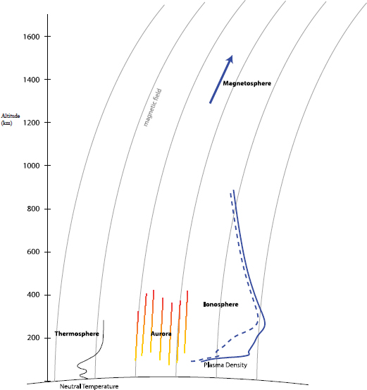
FIGURE 5.1 Approximate altitude ranges of the ionosphere, thermosphere, and base of the magnetosphere. The neutral temperature and plasma density profiles (solid, day; dashed, night) are representative of typical conditions. SOURCE: William A. Bristow, University of Alaska, Fairbanks.
used in space physics (VLF) and working upward through the HF, VHF, and UHF bands, and finally the L-band. Table 5.1 summarizes the spectrum usage based upon currently operating instruments. The chapter concludes with a brief discussion of radio spectrum issues experienced by space physics active remote sensing.
TABLE 5.1 Characteristics of Space Physics Remote Sensing Transmitters
| Radar | Location | Frequency (Bandwidth) | Power | License |
| Arecibo HF | Arecibo, Puerto Rico | 5.1 MHz and 8.175 MHz | 600 kW | NTIA |
| Arecibo ISR | Arecibo, Puerto Rico | 430 MHz, 500 kHz BW | 2.5 MW | NTIA |
| Digisonde | Global | 2 MHz–30 MHz | 300 W | |
| GPS/GNSS | Global/space-based | 1100 MHz to 1600 MHz | ||
| HAARP | Gakona, Alaska | 2.6 MHz-9.995 MHz instantaneous BW 200 kHz | 3.6 MW CW | NTIA |
| Homer VHF | Homer, Alaska | 29.795 MHz 100 kHz BW | 15 kW | FCC experimental noninterference |
| Jicamarca ISR | Jicamarca, Peru | 49.92 MHz 1 MHz BW | 6 MW | Peruvian |
| Millstone Hill ISR | Westford, Massachusetts | 440.0, 440.2, 440.4 MHz, 1.7 MHz BW | 2.5 MW | NTIA noninterference |
| PFISR | Poker Flat, Alaska | 449.5 MHz 1 MHz BW | 2 MW | NTIA primary |
| RISR | Resolute Bay, Nunavut, Canada | 442.9 MHz 4 MHz BW | 2 MW | Industry Canada |
| Sondrestron | Kangerlussuaq, Greenland | 1287-1293 MHz 1 MHz BW | 3.5 MW | |
| SuperDARN | Global | 8 MHz-20 MHz instantaneous BW 60 kHz | 10 kW | Within United States, FCC experimental noninterference |
NOTE: Acronyms are defined in Appendix D.
SCIENTIFIC AND OTHER APPLICATIONS
Ionosphere-Thermosphere Science
As illustrated in Figure 5.1, the ionosphere and thermosphere are atmospheric regions that occupy the same volume of space: one is ionized (the ionosphere) and the other, neutral (the thermosphere). The thermosphere is the region of Earth’s atmosphere above the mesopause (~90 km), making it the highest-altitude region of the atmosphere. It is characterized by a mass density profile that decreases exponentially with increasing altitude and a temperature profile that increases with increasing altitude. The ionosphere is the ionized portion of the atmosphere ranging from an altitude of about 50 km up to about 2,000-3,000 km. The ionosphere and thermosphere regions are coupled by collisions between ions and neutral molecules, which influence the energetics and dynamics of both regions.
The ionosphere is formed by the ionization of the neutral atmosphere, primarily by solar ultraviolet radiation, which varies with time of day, the seasons, geographic location, and level of solar activity. The lowest ionization energy (and hence longest wavelength) of the major atmospheric constituents is 12.1 eV for molecular oxygen. The corresponding wavelength is 102.6 nm, which is classified as extreme ultraviolet (EUV). Ionization of the other major constituents requires shorter wavelengths, ranging from 79.6 nm for molecular nitrogen, up to 91.1 nm for atomic oxygen. While solar irradiance peaks in the visible wavelength range, there is sufficient power spectral density at EUV wavelengths to produce the ionosphere. The spectral density below 100 nm is in the range of 10–3 to 10–2 W/m2/nm,3 which is about five or six orders of magnitude lower than the spectral density in the visible wavelengths. At these wavelengths, however, the temporal variability can be orders of magnitude larger than that at visible wavelengths. The temporal variability in solar activity includes changes in the long-term average value over a sunspot cycle, as well as short-term bursts during events like solar flares. This variability of the ionization source gets reflected into corresponding variations in the height profiles of the plasma density and atmospheric temperature.
Another major ionization source is energetic particle precipitation, which can come from either the solar wind or the magnetosphere. Typically solar wind particles entering the upper atmosphere are relatively low energy (approximately hundreds of electron volts) and result in high-altitude ionization. Occasionally, these particles can reach MeV energies, in which case they are referred to as solar energetic proton events, and can produce ionization at altitudes as low as 50 km. Such events cause shortwave radio blackouts, preventing communication at HF frequencies that are used by, for example, airliners flying on polar routes and military patrols on remote deployments. Energetic particles of magnetospheric origin arise from regions with structure of the plasma pressure or velocity. Depending on the region and dynamics, these particles can reach energies of tens of kilo-electron volts or more and can cause ionization over the full range of ionospheric altitudes. In addition to creating ionization, these particles are responsible for creating the aurora.
While solar EUV radiation and energetic particle precipitation produce ionization, the resulting distribution of plasma density is determined by various chemical reactions taking place in the ionosphere, along with plasma motions, which can transport the plasma across latitudes, longitudes, and altitudes. Figure 5.2 shows typical altitude profiles of electron density and temperature calculated by a
___________
3 See, for example, J. Lean, Solar ultraviolet irradiance variations: A review, Journal of Geophysical Research 92(D1):839-868, 1987.
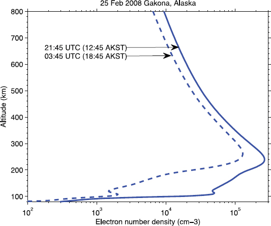
FIGURE 5.2 Profile of ionospheric electron density as calculated by the Self-Consistent Ionosphere Model (SCIM). SOURCE: Courtesy of Christopher Fallen, University of Alaska, Fairbanks, see C.T. Fallen, J.A. Secan, and B.J. Watkins, In-situ measurements of topside ionosphere electron density enhancements during an HF-modification experiment, Geophysical Research Letters 38:L08101, 2011, doi:10.1029/2011GL046887.
numerical ionospheric model.4 The density is insignificant below about 100 km, increases rapidly to a local peak at around 130 km (E-region), then, after a local minimum, rises to its peak value at around 250 km (F-region). Above the peak, it decreases gradually until at very high altitudes it levels off at the magnetospheric plasma density.
Remote sensing of the ionospheric plasma density and temperature profiles coupled with observations of the solar irradiance at altitudes above the ionosphere
___________
4 C.T. Fallen, J.A. Secan, and B.J. Watkins, In-situ measurements of topside ionosphere electron density enhancements during an HF-modification experiment, Geophysical Research Letters 38(8):L08101, doi:10.1029/2011GL046887, 2011.
enable studies of the physics and chemistry that govern the formation of the ionosphere and its characteristics. Coupling the observations with magnetospheric satellite observations enables studies of magnetospheric dynamics.
The two main active remote sensing instruments used for observing the ionospheric plasma density are ionosondes and incoherent-scatter radars (ISRs). Ionosondes are swept frequency devices that measure plasma density as a function of altitude up to the altitude where the density peaks. They transmit short pulses at a series of frequencies below the peak plasma frequency of the ionosphere and observe the time between transmission and reception of each pulse to determine the altitude from which it was reflected. They cannot provide information on the plasma above the altitude of the peak. ISRs are single-frequency radars that observe backscatter from thermal fluctuations of the plasma at all altitudes with significant density up to the point where returns become too weak to detect. These observations, when coupled with the well-developed theory of incoherent-scattering from plasmas, provide altitude profiles of a number of parameters, including plasma density, plasma temperature, plasma velocity, ionic composition, and ion-neutral collision frequency. Figure 5.3 shows an example of observations from the Poker Flat, Alaska, Incoherent-Scatter Radar (PFISR) during an interval that included the effects of a solar flare. The four panels of the figure show the total plasma density (Ne), and the densities of the three major ion species O+, O2+ and NO+. The rapid increase in plasma density observed just prior to 0100 UT was due to x rays generated by the impulsive X-class solar flare and resulted in a blanking of short-wave radio over a large portion of the side of Earth illuminated by the Sun at the time.
While ISRs provide significantly more information than do ionosondes, the information comes at a cost. A typical ISR costs tens of millions of dollars, while an ionosonde costs on the order of a hundred thousand dollars. The high cost of ISRs has resulted in relatively few being built, while ionosondes are widely distributed. Hence, ISRs provide detailed high-fidelity information at a few strategic locations, and ionosondes provide less detailed information over broad geographic regions.
Ionospheric dynamics are driven by a variety of forces that also vary in time and space. In the lowest altitude region, collisions between the ionized and neutral constituents are the primary influence, while at the highest altitudes there are essentially no collisions, and the dynamics are governed entirely by the electric fields imposed from the magnetosphere. At the altitudes in between, the transition from collisional to collisionless leads to a rich environment for study.
Dynamical processes in the ionosphere lead to plasma instabilities that cause irregularities of the plasma density and temperature. Such irregularities diffuse along the magnetic field to produce what are referred to as field-aligned irregularities (FAIs), which can scatter electromagnetic waves. FAIs have a scattering cross section that can be orders of magnitude larger than the incoherent-scatter cross section, which means that radars of significantly lower sensitivity than an ISR can
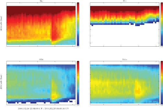
FIGURE 5.3 Observations from the PFISR from 2200 UT February 24, 2014, to 0300 UT February 25, 2014. Top-left: total plasma density; top-right: O+ ion density; bottom-left: O2+ ion density; and bottom-right: NO+ ion density. SOURCE: The Poker Flat Incoherent Scatter Radar (PFISR) is operated by SRI International on behalf of the U.S. National Science Foundation under NSF Cooperative Agreement AGS-1133009.
detect them. Radars that observe scatter from FAIs are referred to as coherent-scatter radars. Coherent-scatter observations provide information not only on the scattering cross section but also on the Doppler shift produced by the irregularities, which can be used to study the dynamical processes that generate the irregularities. In addition, at high altitudes (F-region), the FAIs convect with the bulk plasma, which means that observations of their velocity provide information about the bulk-plasma velocity. At lower altitudes (E-region) the irregularities do not drift with the bulk plasma velocity but can provide detailed information on the plasma instability mechanisms that led to their creation.
Magnetospheric Physics
The magnetosphere is the volume of space formed by the interaction of Earth’s magnetic field with the solar wind and the interplanetary magnetic field (IMF). It surrounds Earth, extending from about 10 Earth radii from Earth’s center on the
sunward side to as much as 200 Earth radii on the antisunward side. Magnetospheric plasma comes from two sources: capture of solar wind plasma at the boundary, and upwelling of plasma from the ionosphere. Within the magnetosphere, plasma dynamics and energetics are determined by internal processes driven by interactions with the solar wind and IMF at the outer boundary, which is referred to as the magnetopause. Figure 5.4 shows a sketch of the magnetosphere including some of its subregions. Within these subregions the plasma and/or the magnetic field exhibit characteristic properties (such as open or closed field lines, hot plasma or cold plasma, etc.) usually related to the internal dynamics or the driving. For example, the region identified as the Cusp derives its name from the topology of the magnetic field within the region. Magnetic field lines in the cusp are identified as open, having a footpoint on Earth and mapping out to the magnetopause. It is a region of strong interaction between the solar wind/IMF and the magnetosphere and drives much of the dynamics of the entire magnetosphere.
The primary goal of magnetospheric physics is to understand the complex chain of interactions that couple solar wind energy and momentum into the upper atmosphere. Doing so requires understanding the processes occurring at the mag-
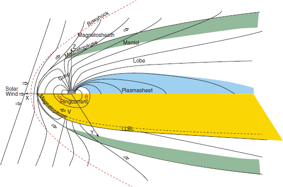
FIGURE 5.4 Sketch of Earth’s magnetosphere identifying various regions. SOURCE: Courtesy of Antonius Otto, University of Alaska, Fairbanks.
netopause and the internal dynamics of the magnetospheric regions. It is necessary to understand and observe how plasma and magnetic flux are transported within the system, and how the magnetosphere and ionosphere are coupled. In addition, there are events known as magnetic storms and auroral substorms that are characterized by rapid global-scale configuration changes in the magnetosphere that can have significant impacts on technological systems. Understanding the causes and characteristics of these events is another focus of magnetospheric physics.
Ground-based active remote sensing uses observations of the ionosphere to study the magnetosphere, which is possible because the patterns of particle precipitation and plasma velocities observed in the ionosphere can be mapped to the magnetosphere. As discussed in the section covering ionospheric science, energetic particle precipitation from the magnetosphere produces plasma in the ionosphere that can be sensed using ISRs. The ISR measurements provide regional patterns of the precipitation morphology and can be used to infer the energy flux and characteristic energy of the precipitation. The observations are spatially and temporally resolved, with resolutions on the order of kilometers and time resolution on the order of seconds. ISR observations also provide information on the flow of ions from the ionosphere to the magnetosphere. This ionospheric outflow is at times the major source of magnetospheric plasma. Understanding the conditions under which it occurs and the mechanisms by which it occurs are topics of considerable current research.
One of the most significant ways in which ground-based active remote sensing contributes to magnetospheric research is through observations of the high-latitude plasma flow patterns. Characterizing the patterns requires observations over broad regions in both the northern and southern hemispheres, from midlatitudes to the poles. An international network of coherent-scatter radars known as the Super Dual Auroral Radar Network (SuperDARN)5 has evolved to provide these observations. Pairs of SuperDARN radars measure line-of-sight components of the F-region plasma velocity in common volumes from different directions. By combining the observations from all of the radars in the network, maps of velocity vectors are created. The maps cover both hemispheres from about 50° magnetic latitude to the poles with spatial resolutions of about 100 km and temporal resolution of about a minute. Observations from SuperDARN are used in nearly all aspects of magnetospheric research.
___________
5 R.A. Greenwald et al., DARN/SuperDARN: A global view of high-latitude convection, Space Science Reviews 71:763-796, 1995.
Radio Science
Broadly speaking, radio science is a scientific and engineering discipline focusing on the generation and propagation of electromagnetic waves. Space physics aspects of radio science address how space plasmas affect the propagation of waves, or conversely, how the waves can affect space plasmas. While radio science is identified as a distinct discipline, it is closely related to both ionospheric research and magnetospheric research. There are direct practical applications of radio science, including the understanding of impacts on transionospheric propagation of satellite communication, navigation, and remote sensing signals.
When a radio signal passes through a plasma, its propagation is influenced by the index of refraction along its path. The index of refraction of a plasma is different from that of free space and depends on the frequency and polarization of the signal, the density of the plasma, and the strength and direction of the ambient magnetic field. The index of refraction determines the velocity of propagation of signals and, hence, the time it takes for signals to propagate from their source to their point of reception. For signals that are used for timing and navigation (GPS and GNSS), knowledge of the propagation time is critical for proper operation. When a signal encounters a smooth gradient of the index of refraction, it is refracted, changing its propagation direction. Radar signals that rely on knowledge of the signal line of sight must be able to account for such refraction. In regions of turbulent changes of the index of refraction, interference among different signal paths creates constructive and destructive interference that lead to amplitude and phase fluctuations referred to as scintillations.
Just as plasmas affect electromagnetic wave propagation, electromagnetic waves can affect plasmas. The electric field of a wave accelerates the charged particles of the plasma, which can lead to a variety of plasma phenomena. The most basic result of electromagnetic wave passage is a general heating of the plasma. The heating is caused by collisions among the accelerated charged particles, which randomizes the particle velocities. In addition to heating, a variety of plasma instabilities can be excited, generating a plethora of plasma wave modes. Studying these effects has led to the construction of facilities, colloquially known as ionospheric heaters, that transmit high-power high-frequency waves into the ionosphere and diagnose the impacts using remote sensing instruments.
Space Weather
Space weather is a relatively new discipline that encompasses the other disciplines of space physics but focuses on societal impacts and on prediction of events with potentially adverse effects. Examples of such effects include increased level of ionospheric scintillation causing outages of GPS signals, induced currents in power
systems caused by ionospheric currents, and increased radiation belt particle fluxes causing damage to satellites.
Large space weather events can have severe societal impacts. One of the most cited examples is a March 1989 geomagnetic storm in which the Quebec power grid was disrupted, leaving over 800,000 customers without power for nearly 10 hours. During the event, currents flowing in the ionosphere induced currents in the power system of sufficient magnitude to trip circuit breakers in the grid’s transmission lines, leading to the widespread outage.
The goal of space weather research is to predict the occurrence and intensity of such space phenomena, with the expectation being that the availability of such predictions would allow system operators to take steps to mitigate the potentially adverse effects. Making predictions with useable accuracy, however, is a rather daunting task.
Predicting space weather is difficult for several reasons. First, the volume of space that contributes to the impacts is large. As discussed in earlier sections, electric fields and particle precipitation map along Earth’s magnetic field. As a result, conditions at one location are influenced by conditions in regions that may be many tens of Earth-radii away. Secondly, the evolution of the magnetosphere-ionosphere system in time is a strong function of the drivers, but also depends on the state of the system at the time the drivers become active. Changes of the main drivers, the solar wind and IMF, are communicated rapidly to the entire system and can induce effects within minutes after reaching the magnetopause. The precise nature of the effects depends critically on the state of the system. For example, if an IMF transition that would increase the level of driving arrives at the magnetopause at a time when the system is quiescent, it would likely induce increased convection and a general expansion of the auroral oval toward lower latitudes. If, however, the magnetosphere is in an excited state when the transition arrives, the effects will be quite different. Within a short time, the increased convection could result in a magnetospheric substorm, which is the rapid release of energy stored in the magnetotail, resulting in active auroral displays, large ionospheric currents, and highly structured ionospheric plasma.
The sheer volume of the magnetosphere makes characterization using in situ sensing impractical. Hence, observations of the magnetosphere-ionosphere state can be obtained only through remote sensing. As discussed above, the high conductivity of the magnetospheric magnetic field lines makes these observations possible. The same convection and particle precipitation measurements used in basic magnetospheric and ionospheric research apply to space weather as well. Remote sensing observations can be used for a variety of space weather measurements, including the strength of convection, the latitude of auroral precipitation, the location of auroral currents, and the location of potentially scintillation-causing irregularities.
Ionospheric active sensing observations use radio transmitters that operate at frequencies ranging from kilohertz up to a few gigahertz, with certain ranges being more actively used than others. The observations come primarily from ground-based radar systems but include satellite-borne radio beacons. This section provides a summary divided into ground-based and space-based systems, starting with the lowest frequencies and working upward. In each case, the choice of frequency is directly related to the type of information sought from the observations. In almost every case, the frequency is determined by the properties of the target medium. In order to sense the plasma for the desired measurement, it is necessary to use a signal that interacts with it in a specific way. Using a different frequency would not provide the same information. For example, an ISR operating in the UHF band provides information on the density and temperature of the plasma, while a coherent-scatter radar operating in the HF or VHF bands provides information on the spectrum of irregularities present in the plasma. While both instruments provide information on the same plasma, the measurements are distinct.
Ground-Based Radar
VLF Band
The lowest transmitter frequencies used in space physics research are in the VLF band. Though no longer operational, at one time the world’s longest dipole was used to produce VLF signals that directly probed the magnetosphere. The Siple Station, Antarctica, antenna was a 40 km dipole transmitting signals at frequencies around 3 kHz, which were received at the conjugate point in the northern hemisphere at Roberval, Canada. When these transmissions reached the magnetosphere, they interacted with the trapped energetic particle populations, resulting in amplification of the signals and the triggering of other emissions. From the observed signatures it was possible to draw conclusions about the particle populations, and about the wave-particle interactions. No dedicated space physics transmitters operating at the VLF band exist today. To overcome this lack of dedicated transmitters, the research continues using other means. Magnetospheric research using the VLF band has been continued by using HF band heating facilities to generate the signals by modulating electrical currents flowing in the ionosphere. Ionospheric research using VLF signals currently relies on radio navigation and time signals transmitted by various government agencies in the 15-20 kHz band. These signals propagate for thousands of kilometers in the waveguide formed by the ionosphere as the upper boundary, and Earth’s surface as the lower boundary. Small phase and amplitude
fluctuations observed at a fixed site are used to infer properties of the waveguide, which translate to properties of the ionosphere.
HF Band
The next most widely used band for space science is the HF band. As described in the preceding section, “Scientific and Other Applications,” ionosondes measure the altitude profile of electron density in the lower ionosphere by observing reflections of swept frequency signals. When a wave propagates into a region where the plasma frequency is comparable to but below the wave frequency, the propagating wave experiences a decrease in velocity and a change in direction. As the wave approaches an altitude where the plasma frequency is equal to the wave frequency, the phase index of refraction approaches zero and the wave reflects. Usually an ionosonde begins its transmissions at a frequency of around 1 MHz or lower and steps to some upper frequency determined by the highest expected plasma frequency, which may be 20 MHz or higher. At each frequency step, short pulses are transmitted, then reflected by the plasma and received by the ionosonde receiver. The time between transmission and reception is used to estimate the altitude of the reflection boundary. Successively higher frequencies reflect from higher altitudes until a frequency is reached that is above the plasma frequency at the density peak altitude. Beyond this frequency, no more reflections are observed.
There are a few different ionosonde designs in use today. The most common model is the Digisonde, manufactured by Lowell Digisonde International. The system can transmit between 200 kHz and 30 MHz, with a peak power of 300 W. Over 150 Digisondes have been built since 1969, of which more than 60 remain in operation today and are part of the Global Ionospheric Radio Observatory (GIRO). GIRO is a distributed network of ionosondes that provide specification of the ionospheric electron density below the F-region peak altitude over much of the globe.
Ionospheric heating uses high-power transmitters to study the interaction of radio-frequency electromagnetic waves with plasmas, with waves of high enough amplitude to cause measurable effects. In heating experiments, energy is transferred from the electromagnetic waves to the plasma. The mechanism for the energy transfer depends on the properties of the plasma and the frequency and polarization of the waves. If the frequency of the wave is close to one of the resonant frequencies of the plasma, energy coupling is highly efficient, and the transfer can lead to explosive growth of plasma instabilities. Away from a resonant frequency, the energy transfer is less efficient, but because of collisions among the plasma constituents or between the plasma and the neutral gas, the energy transfer leads to a general heating of the plasma, modifying the properties of the plasma, such as its electrical conductivity. In addition, the heating can lead to motion of the plasma through diffusion and thermal upwelling. Because of energy coupling mechanisms,
ionospheric heating is possible only in the lower portion of the HF band; lower frequencies would not reach the ionosphere, and higher frequencies would pass through the ionosphere with little interaction.
In the process of radio-frequency ionospheric heating, interesting and useful effects can be produced. For example, under suitable ionospheric conditions, operating the transmitter in a mode that deposits energy into the D-region and lower E-region can alter the ionospheric conductivity and modulate the naturally occurring electrojet currents, which as a result radiate electromagnetic waves at the modulation frequency. ELF/VLF waves generated in this manner have been measured with significant amplitudes both on the ground and in space. Other effects include the generation of field-aligned irregularities in the plasma, artificial auroras, large-scale modification of the plasma density, and stimulated electromagnetic emissions.
In the United States, there are two HF band heating facilities. The High-Frequency Active Auroral Research Program (HAARP) facility at Gakona, Alaska, operates at frequencies between 2 MHz and 10 MHz and is capable of transmitting 3.6 MW of continuous power. The facility has a large phased-array antenna consisting of 180 crossed dipoles covering about 33 acres. It is the highest-power, broadest-frequency, and most flexible facility of its kind. The second U.S. facility is currently under construction at the Arecibo Observatory. The facility will use an array of dipoles below a wire subreflector suspended over the 300 m diameter dish. While the facility will not cover the same range of frequencies as HAARP or achieve the same power level, it will have the advantage of being colocated with the Arecibo Incoherent-Scatter Radar, which is the most sensitive ISR in the world. Having such a powerful diagnostic instrument is a significant advantage for detailed studies of the plasma processes under investigation.
SuperDARN is an international network of coherent-scatter radars used for observing plasma flows in the ionosphere. At present, the network consists of 33 radars distributed around the globe, with 22 in the Northern Hemisphere and 11 in the Southern Hemisphere. The observation mechanism used by coherent-scatter radars differs from that of ionosondes. While it is still necessary to use a frequency that interacts with the plasma, the scattering mechanism is Bragg scatter from field-aligned irregularities, which arises in regions where there are spatially periodic fluctuations of the plasma density with a wavelength equal to half of the probing wavelength. Regions of plasma turbulence have a broad spectrum of wavelengths, so usually if turbulence is present there will be a component with the appropriate spatial scale. Scattering occurs whenever the wavelength-matching criterion is met, but the scattered signal returns to the radar location only when it is directed along the line from which it came. SuperDARN uses the HF band because refraction of the signals bends them toward the horizontal, resulting in perpendicularity to the magnetic field over large regions of space and particularly in the F-region at
auroral-zone and polar cap latitudes. SuperDARN uses frequencies between about 8 MHz and 20 MHz, though at any given time, each radar operates on a single frequency and uses only about 30 kHz to 60 kHz of bandwidth.
VHF Band
Like HF coherent-scatter radars, VHF radars target field-aligned plasma irregularities. The lack of significant refraction at the VHF band, however, greatly impacts the focus of the research. As discussed in the previous section, observing the scatter from field-aligned irregularities requires the probing signal to be perpendicular to Earth’s magnetic field. Without refraction, however, perpendicularity to the field at F-region altitudes cannot be achieved at high latitudes. The result is that research investigations using VHF coherent-scatter radars focus primarily on observations of E-region plasma irregularities.
In the United States, there are two currently operational fixed-location VHF radars for ionospheric remote sensing: one at Homer, Alaska, and one at St. Croix, U.S. Virgin Islands. The radars are operated by Cornell University on a campaign basis at a frequency of 29.795 MHz (technically in the HF-band) at a peak power of about 16 kW. Additional portable radars are operated during research campaigns at a variety of locations. These radars operate at 40.92 MHz and 49.8 MHz and use bandwidths from 200 kHz to 500 kHz and peak power of 30 kW.
UHF Band
The U.S. National Science Foundation supports the operation of six incoherent-scatter radar facilities, three of which are in the United States. Incoherent scatter is a misnomer referring to the scattering of radio waves by individual electrons, which is not the actual scattering mechanism that these radars exploit. The scattering actually comes from thermal fluctuations due to an array of plasma waves. The total scattering cross section is approximately the product of the classical electron scattering cross section and the number of electrons in the scattering volume, which results in very weak scattering, requiring transmit powers of megawatts and antenna gains of 30-50 dB or more.
A well-developed theory of ISR describes the shape of the frequency spectrum of the radar returns.6 The spectrum is a function of several ionospheric parameters, which can be estimated by fitting theoretical curves to the observed spectra. The parameters include the electron density, the ion temperature and mass, the electron temperature, the ion-neutral collision frequency, and the ion velocity. Estimates of
___________
6 See, for example, J.P Dougherty and D.T. Farley, A theory of incoherent scattering of radio waves by a plasma, Proceedings of the Royal Society of London A 259(1296):76-99, 1960.
these parameters are obtained over the full range of ionospheric altitudes, including above the F-region peak.
Existing ISRs operate at frequencies between 50 MHz and 1290 MHz, although most use the band around 400-450 MHz. Analysis of ISR theory shows that this band is nearly optimum in terms of the altitude coverage and radar sensitivity. Lower frequencies would require larger antennas to achieve the same antenna beamwidths, and the noise from external sources would increase greatly. At higher frequencies the wavelength approaches the Debye length (a length scale below which collective effects no longer shield individual charges) and the spectrum becomes that of simple Thompson scattering. The result is that many of the ionospheric parameters cannot be determined using such frequencies.
Satellite-Borne Radar
Satellite-borne beacon transmitter signals and GPS/GNSS signals are used for ionospheric science and radio science by studying the integrated effects of propagation from the satellites to receivers on the ground. These effects relate to the total time a signal takes to propagate from the satellite to the ground, and how the amplitude and phase of the signals vary in time. Both effects are related to propagation through ionospheric plasma and can be used to infer ionospheric properties.
Time variations of the amplitude and phase of the signals are related to spatial variations of the index of refraction along the path. Variations with scales on the order of the diameter of the Fresnel zone at ionospheric altitudes cause constructive and destructive interference of the signals. Passage through regions with irregularities of this size can lead to rapid fluctuations of the signals, referred to as scintillation. When scintillations become severe, as may occur during geomagnetic storms, they can cause loss of receiver lock, leading to outages of the system.
The total time between transmission and reception is proportional to the integration of the index of refraction along the path, which is related to the total number of electrons along the path, referred to as the total electron content (TEC or slant TEC). Precise measurements of the signal propagation times are used to estimate TEC along the transmission paths. By observing multiple satellites from multiple ground locations, maps of TEC are produced covering large areas of the globe. In addition, in some regions there are dense arrays of receivers that use the line-of-sight TEC observations in a tomographic inversion to produce three-dimensional volume estimates of electron density.
Satellite beacons have used frequencies from the HF band through the L-band (Table 5.1).
The characteristics of the various space physics active remote sensing instruments vary significantly from instrument to instrument, which means that the spectrum issues also vary significantly. In the VLF band, the instruments use navigation and timing signals generated by others. The band is not heavily used for other purposes, and there are few spectrum issues. While the primary interference signals in the HF band are environmental (cosmic background and terrestrial lightening), increased usage for communication and broadcasting means that at times no clear frequencies are available that can be used by the HF radars. At the UHF and L-bands, crowding of the bands has become a significant problem. The most telling example is the allocation of a band near 900 MHz for telecom use in Finland and Sweden, resulting in the loss of the band for use by the European Incoherent Scatter Radar (EISCAT). Their operations now rely entirely on their VHF system. In the United States, radars operating in the band near 430 MHz share the band with Department of Defense (DOD) radars, which have priority. The PFISR system is allowed to operate at the edge of the band occupied by the DOD radar at Clear Air Force Station, Alaska, but was allowed to do so only after extensive testing showed that it did not interfere with that system. Even at the edge of the band, the PFISR system experiences significant RFI at times.
Future advances in space physics research will rely on increasing spatial and temporal resolution and sensitivity, which will increase bandwidth and power requirements for active remote sensing. To some extent, the future demands are unknown and will be driven by individual investigators proposing new instruments or enhancements to the existing ones.
Finding 5.1: Active remote sensing plays a vital and central role in space physics research, which provides societal benefits. These benefits are both direct, in characterizing impacts on technology critical to government and industry, and indirect, in providing a fundamental understanding of our space environment.
Finding 5.2: The choice of frequencies and associated bands used in space physics active remote sensing are determined primarily by the physical properties of the medium being probed.
Finding 5.3: The information provided by ionospheric active remote sensing cannot be obtained by other means.
Recommendation 5.1: Access to the spectrum currently used in space physics remote sensing should be maintained.
Recommendation 5.2: The next decadal survey in solar and space physics should address the future spectrum needs for the space physics research community.
Recommendation 5.3: NASA and the National Science Foundation should conduct a formal survey of the space physics research community to determine future spectrum needs.


