
Radio-Frequency Interference Issues for Active Sensing Instruments
The objective of this section is to give an overview of current spectrum issues encountered with active science sensors, the resultant impact to the objectives of the science investigations, and the nature and limitations of mitigation strategies that may be employed.
For the purposes of this discussion, “spectrum issues” essentially fall into two categories:
- Radio-frequency interference (RFI). This is the interference from other radio services impacting the performance of active science sensors. Unlike passive science systems, where regulatory effort is made to keep the allocated band free of other emitters, active science systems are often expected to share the band with other services, so signals from other radio services are often present to varying degrees. Various mitigation techniques may be employed to lessen the impact of this interference.
- Sensor transmit restrictions. Active sensors emit radiation and thus may interfere with other services that share the band. National and international regulatory bodies can place limits on how science systems operate.
As noted in earlier chapters, a radar system senses a medium of interest (atmosphere, land, ocean surface, or others) by extracting information from the “echo,” or “radar return,” received from that medium. Radar sensors operate in a variety of bands ranging from 2 MHz to 300 GHz (with potential applications outside this range).
When a signal from other radio sources (communication systems, aircraft tracking radars, etc.) is present with the echo, this is termed RFI. RFI can corrupt the desired science measurement in a number of ways, depending on what the sensor is intended to measure and how the sensor system is designed (Figure 8.1). Depending on the application, a sensor extracts information based on one or more of the following signal characteristics of the echo: (1) amplitude, (2) frequency, (3) time delay, (4) polarization, (5) Doppler shift, or (6) phase. The sensitivity of a given sensor to RFI is also a function of the specific nature of the RFI experienced. The existence of a wide range of active sensor techniques, as well as a wide variety of RFI environments encountered globally, conspire to make it difficult to characterize the RFI problem and the associated solutions.
In general terms, RFI may be described as follows:
- Narrow-band RFI. These sources have spectra that are narrow relative to the bandwidth of the sensor and may typically be described as continuous in time relative to the sensor integration time. A classic example of such a signal is a single-frequency sinusoidal tone. Commonly encountered cases include commercial land-mobile radio and amateur radio.
- Pulsed RFI. These sources are pulsed in time, with on/off cycling that may be longer or shorter than the sensor integration time and may have bandwidths narrow or wide relative to the sensor bandwidth. A typical example is a ground-based radiolocation radar.
- Broadband, noiselike RFI. These sources are composed of signals modulated to relatively broad bands, and usually are continuous in time relative to the radar integration time. Examples of such systems include broadband communication and data systems, as well as other coded signals such as GPS. Over the bands in which they operate, these sources have noiselike characteristics.
- Heterogeneous RFI environments. Particularly for airborne and spaceborne sensors that have a wide geographic field of view—either within the main antenna beam or within the extended side lobes—multiple RFI emitters of multiple different types can be viewed simultaneously.
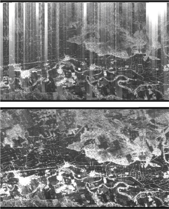
FIGURE 8.1 Sample images collected with the Jet Propulsion Laboratory’s (JPL’s) AIRSAR P-band radar system. The top image shows scene heavily contaminated with radio-frequency interference (RFI), which is often present at the P-band. The bottom image shows same scene after RFI mitigation is employed, in this case largely successfully because of the narrow-band nature of the interference encountered. SOURCE: Courtesy of NASA/JPL-Caltech.
Because science sensors share bands with other services, and because the global RFI environment has generally been growing worse over time, the science community has employed a variety of RFI mitigation methods to protect its sensors from damage or to improve science performance in the presence of the RFI environment. Generally, these mitigation techniques include one or more of the following:
- Receiver protection. At some frequencies, there are emitters that are sufficiently powerful to damage the sensitive receivers of active systems (such as military radars). Consequently, the sensor receiver electronics must be designed to survive such levels if they are expected to be encountered. A limiter placed in front of sensitive components is a common protective measure.
- Out-of-band filtering. It is desirable to reject RFI signals outside the sensor band. In addition to protecting the receiver against potential damage from strong signals, undesired nonlinear effects such as receiver saturation and spurious harmonics can occur during the reception of the in-band signal even when the RFI occurs out of band if sufficient rejection is not achieved.
- Geographic avoidance. The simplest way to avoid RFI is to operate the sensor in a location where RFI is not present. Although it might be possible to locate some types of science measurements in sufficiently remote locations, this may be impractical for most airborne systems, and even more difficult for spaceborne systems.
- Frequency avoidance. It may be possible to operate a science sensor in a band where no interference is present. Since the bands used by active science sensors are often well-used by other services sharing the band, it can be difficult to choose a single fixed frequency a priori, and consequently, some sort of tuning capability is often required to realize this technique.
- RFI detection. Although not a mitigation technique per se, the ability to detect and characterize RFI is important in implementing various measures. In cases where interference present in the science data is sufficient to corrupt the desired measurement accuracy, it is necessary to detect the presence of RFI so that the data can be discarded. Detection is also a necessary first step if the RFI is to be removed. In general, RFI detection techniques focus on identifying the presence of signals significantly different from the expected echo return. Examples of interference detection are the presence of narrow-band interference appears as a conspicuous spike in the Fourier transform domain; pulsed RFI appears as statistically significant spikes in the time domain; also, many radar returns from the surface have Gaussian statistics due to speckle, and thus the presence of RFI may be detected by
-
signal statistics exhibiting non-Gaussian behavior. Note that RFI detection techniques are most effective when the raw science data are available (the original A/D samples of the echo return). If, for example, there is significant compression of the raw radar echo by onboard processing or averaging, the detection of low to moderate RFI signatures may be much more difficult.
- RFI removal. When adequate raw data exist, it is sometimes possible to remove offending RFI signals and consequently recover science data of improved quality. The simplest example of this is the notch filtering of a very narrowband interfering signal or the excision of time-domain outliers consistent with interference from pulsed radars. Under certain conditions, it may also be possible to estimate the offending interference and attempt to directly subtract it from the science data. All of these techniques come with some cost in that the process of interference excision and/or subtraction also corrupts the desired science signal to some degree. There is also often a significant added cost in terms of designing, implementing, and operating the RFI removal steps. In general, the more sparsely an interfering signal occupies the time or spectrum domain, the easier it is to detect and excise without corrupting the underlying science data. Examples of very sparse signals would be a single narrowband tonelike signal in the frequency domain, which can be notched while retaining most of the wider-band science data, or that from a single ground surveillance radar with pulses at a rate much slower than the active sensor samples, where the blips associated with this interfering source can be detected and excised from the sensor averaging or processing. Wideband, noiselike sources and heterogeneous environments present more difficult problems for removal techniques. First, such signals are harder (or, in some cases, impossible) to detect because they are not neatly concentrated at discrete times or frequencies, or may have “more Gaussian” statistics that are less easily discriminated from the science sensor echo. Secondly, the removal of such wideband or complex signals would necessarily involve the removal of significant portions of the desired echo and compromise the science measurement.
- Cooperative operation. The preceding mitigating techniques are “unilateral” in the sense that the active science system reacts to the existing RFI environment without trying to modify it in any way. In some circumstances, it may be possible for science sensors to operate cooperatively with other services. For instance, a ground radar or communication system may agree to turn off or switch frequency when a science sensor is known to be present.
It should be noted that the above mitigation techniques are most effectively implemented in the design phase of the sensor with a specific RFI environment in mind. Some sensor systems have been deployed without full knowledge of the RFI
environment, but, luckily, the nature of the interference was such that removal techniques could be implemented in postprocessing. To ensure effectiveness, however, the RFI environment to be mitigated should be clearly understood before sensor deployment, flight, or launch. This understanding can be a very difficult objective to achieve given the varied and evolving RF environment around the world today.
SCIENCE SENSOR TRANSMIT RESTRICTIONS
Through the spectrum regulatory process, operational restrictions are often imposed upon active science sensors so that they do not interfere with incumbent radio services. Examples of operational restrictions include the following:
- Geographical restrictions. An active science sensor may be restricted from operating near another service—for instance, a military radar “keep out” zone imposed on an airborne sensor. This can be a severe restriction for a spaceborne sensor because it typically has a very large field of view, particularly if the antenna side lobes of the science sensor are considered a problem for the other service. Consequently, such geographic restrictions on spaceborne sensors may result in significant loss of science data coverage, potentially denying coverage of entire continents.
- Transmit power restrictions. The maximum radiated power of science sensors, expressed in terms of effective isotropic radiated power (EIRP) or flux density incident in the vicinity of other receivers, may be restricted to certain levels, which may limit the detection of signals from weak scattering media.
- Transmit waveform modifications. An active sensor may be required to modify its transmit waveform to avoid interfering with other services. For narrowband science sensors, this may be accomplished by tuning the transmit carrier frequency away from the service potentially being interfered with. For broadband sensors, some measurements may allow the spectral “notching” of the transmitted waveform. For example, some synthetic aperture radars (SARs) operating in crowded spectral environments have the ability to generate an FM linear-chirped signal with both narrowband and wideband notches at specific frequencies. Such a waveform modification requires advanced coordination to know which frequencies must be suppressed and a sophisticated arbitrary waveform generation capability; moreover, depending on how much the transmit spectrum is required to be notched, the science measurement may be significantly compromised due to resolution loss and increased side lobes.
CURRENT SPECTRUM ISSUES BY FREQUENCY BAND
The intent of this section is to provide specific examples of some of the spectrum issues currently being encountered by science researchers, in terms of both RFI and operational restrictions. This section is organized by frequency band, starting at 3 MHz and going up to 300 GHz. A variety of different types of active sensing systems are illustrated. Spaceborne systems are treated with perhaps the most thoroughness because they are sensitive to RFI on a global basis, provide data to a very large number of users, and are relatively few in number (presenting a manageable set in terms of a more comprehensive treatment). Spaceborne systems also are subject to well-defined spectrum allocations from the International Telecommunications Union’s (ITU’s) Earth Exploration Satellite Service Active (EESS-Active) bands, as shown in Table 8.1. Some airborne and ground-based sci-
TABLE 8.1 EESS-Active Allocated Bands and Other Services Operating in Bands
| Band Designation | Frequency (MHz) | EESS-Active Allocation Status | Other Services in Band | Sharing Considerations by Service and by Band |
| P-band | 432-438 | Secondary | Radiolocation, amateur, amateur satellite, fixed, mobile, ISM, space operation service (Earth-to-space), aeronautical radio navigation | RS.1260: wind profiler radars, space object tracking radars, launch vehicle range safety command destruct receive frequency RS.1282: avoid FM pulsed wind profiler radars RS.1749: mitigation techniques to share with radiolocation and radio navigation radar systems |
| L-band | 1215-1300 | Primary | Radiolocation, RNSS, amateur (secondary) | RS.1280: processing gain of search radars RS.1347: increase in loop SNR of RNSS receiver |
| S-band | 3100-3300 | Secondary | Radiolocation | RS.1280: processing gain of search radars |
| C-band | 5250-5460 | Primary | Radiolocation (active and secondary), Aeronautical RNSS | RS.1280: processing gain of search radars RS.1632: sharing feasible with RLANs having constraints |
| Band Designation | Frequency (MHz) | EESS-Active Allocation Status | Other Services in Band | Sharing Considerations by Service and by Band |
| C-band | 5460-5570 | Primary | Radiolocation | RS.1280: processing gain of search radars |
| X-band | 8850-8650 | Primary | Radiolocation | RS.1280: processing gain of tracking radars |
| X-band | 9300-9800 | Primary | Radiolocation, radio navigation Fixed | RS.1280: processing gain of tracking radars Compatible with fixed, but only for bandwidths > 500 MHz |
| 9800-9900 | Primary | |||
| Ku-band | 13250-13750 | Primary | Aeronautical RNSS, radiolocation | RS.1281: Constraints on EESS (active) for “short dwell” and “long dwell” |
| Ku-band | 17200-17300 | Primary | Radiolocation | |
| K-band | 24050-24250 | Secondary | Radiolocation, amateur (secondary) | |
| Ka-band | 35500-36000 | Primary | Radiolocation, MET-AIDS, fixed, mobile | RS.1628: Constraints on pfd of EESS (active) to share with radiolocation radars, compatibility with fixed service |
| W-band | 78000-79000 | Primary | Radiolocation, amateur, amateur-satellite, space research (space-to-Earth) | |
| W-band | 94000-94100 | Primary | Radiolocation | RS.1261: mitigation technique to protect radio astronomy in 86-92 GHz, feasible to share with radiolocation, limit band to cloud profile radars |
| mm-band | 133500-134000 | Primary | Radiolocation | |
| mm-band | 237900-238000 | Primary | Radiolocation |
NOTE: Acronyms are defined in Appendix D.
ence sensors also are addressed, with the goal of capturing a representative sample of the issues encountered by these systems, which are typically sensitive to more localized problems. In general, airborne and ground-based systems use a wider spectral range than that prescribed for satellites, typically using the bands identified for radiolocation but not necessarily limited to those bands when authorization to radiate on a “noninterference basis” is granted. Much of the resource material for this section came from an active sensing RFI workshop held at the Jet Propulsion Laboratory (JPL) on November 8, 2013, under the auspices of the committee.1
HF and VHF Bands
Band Usage
The IEEE Standard Letter Designations for Radio-Frequency Bands defines the HF band as between 3 and 30 MHz and the VHF band as being between 30 and 300 MHz. As discussed at length in Chapter 5, active science sensors operating in the HF and VHF bands constitute an important measurement tool for understanding the physics and chemistry of Earth’s upper atmosphere. Space physics transmitters operate at HF and VHF frequencies to take advantage of the natural interactions between the transmitted electromagnetic wave and the ionospheric plasma. These low-frequency bands are also used by radar sounders to probe glaciers, sea ice, coastal ocean regions, and the land subsurface. Earth remote sensing systems share the HF and VHF region of the spectrum with other important services worldwide. Globally, these bands are used for military and government communications, aviation air-to-ground links, amateur radio, shortwave broadcasting, maritime sea-to-shore radio, over-the-horizon radar, and the Global Maritime Distress and Safety System (GMDSS).
Interference Environment for Active Sensors at the HF and VHF Bands
RFI is a well-known issue for science sensors operating at the HF and VHF bands. Owing to the large number of applications in these bands, and the long distance propagation properties of electromagnetic waves, particularly at HF with sky wave reflections, there is an inherently dense RF interference environment present at all times. The interference from remotely located transmitters is most noticeable at night, when the reflection properties of the ionosphere are favorable for multiple-bounce signal propagation. In practice, the impact of RF interference on the operation of active RF sensors for space physics in the HF and VHF bands can be successfully mitigated by determining and selecting a clear operat-
___________
1 See Appendix C.
ing channel. The interfering sources are typically narrowband relative to a 3 kHz channel, and even in periods of maximum congestion, the HF band is less than half occupied. A further mitigating factor is the directionality of the interfering signals, which tend to arrive at low angles due to multiple bounce reflections off the ionosphere. The space physics sensors described in Chapter 5 typically utilize high-directivity antennas pointed at high elevation angles and thus have greatly reduced susceptibility to incoming RF interference at low elevation angles. For airborne radar sounders exploring the depths of polar ice sheets and glaciers, no report of significant deleterious interference from external sources has come to the attention of the committee.
Transmit Restrictions for Active Sensors at the HF/VHF Bands
HF radars used for sensing ocean currents have encountered some issues with operational restrictions, but among other science operating sensors, no significant operational restrictions have come to the attention of the committee. This is likely due to the remoteness of the areas at which many of these sensors operate. Although there is currently no EESS-Active allocation for spaceborne science sensors to operate at VHF, there is some interest in the science community for pursuing one, or at least obtaining authorization to radiate on a noninterference basis. This is due to an interest expressed by both the U.S. and the European science communities for flying ice and subsurface sounding radars on spaceborne platforms. As previously mentioned, because satellites have an inherently wide field of view (often thousands of kilometers), not only would transmit restrictions need to be resolved, but RFI issues would likely be encountered.
UHF Band and P-Band
Band Usage
The IEEE Standard Letter Designations for Radio-Frequency Bands defines the UHF band as between 300 and 1000 MHz, of which the P-band is a subset. The EESS-Active allocation at the P-band is from 432 to 438 MHz, which is a secondary user allocation and therefore has lower priority relative to other users. Multiple airborne radar systems operate in the UHF band. UHF is becoming increasingly important for scientific remote sensing because electromagnetic waves at these frequencies exhibit good penetration properties through foliage, making UHF band radars popular for biomass studies in densely vegetated areas, as well as for applications in which the ground must be viewable in the presence of vegetation. Also, UHF is used when a moderate degree of subsurface penetration is needed,
such as observing soil moisture in the root zone. The UHF frequency is also being explored as a means to penetrate ice sheets.
Examples of airborne SAR systems operating at UHF include the Fugro GeoSAR system (which operates in the band 270-430 MHz) and the NASA/JPL AirMOSS system (which operates in the band 420-440 MHz). The European Space Agency (ESA) BIOMASS radar mission due to launch in 2020 will utilize the full EESS allocation, from 432 to 438 MHz. There are a wide variety of other nonscience services that operate at UHF. The EESS band is also occupied by ground-based radiolocation radars for tracking aircraft and space objects (e.g., the U.S. PAVE PAWS). In addition to radiolocation systems, the wider frequency range typically utilized by airborne sensor systems may also overlap the spectra used by land and mobile communication systems, amateur radio, and other science and meteorological services.
Interference Environment for Active Sensors at the UHF Band/P-Band
In the heavily used UHF band, RFI is routinely observed near populated areas by airborne systems (see, for example, Figure 8.2). In many regions, RFI can cause heavy contamination of a SAR image, rendering it unusable for the intended application if the RFI is not mitigated in postprocessing. The extent of RFI contamination is related to the bandwidth of the science sensor. Narrower band systems such as AirMOSS may observe less interference than much wider band systems such as GeoSAR.
Many of the observed interference signals over the UHF band are narrowband communication signals. For aircraft-based systems, these signals are also observed to be highly nonstationary in time as the aircraft moves from scene to scene. The problem of removal or enhancement of dynamic narrowband interference from wideband signals has long been an active research topic in various disciplines. The most popular adaptive filtering technique is the least-mean-square (LMS) algorithm, which is frequently used to remove the often-encountered narrowband interference present in science measurements at UHF. The AirMOSS project reports that, in the instances where a limited number of narrowband interferers is observed to degrade the image, the LMS RFI removal technique is very successful at cleaning up the data to allow their specific science requirements to be met. Interference from pulsed radars is observed less frequently in the data, but the impact from these systems is readily identified by time domain techniques that search for statistical pulse outliers in the data (i.e., brief events with anomalously high power), and can relatively easily be removed. The wider-band GeoSAR system must invoke a similar RFI removal algorithm more frequently, but measurement objectives are nevertheless met the majority of the time with the cleansed data. The RFI environment to
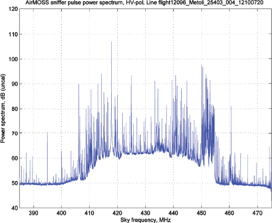
FIGURE 8.2 AirMOSS “sniffer pulse” spectrum containing radar thermal noise with RFI observed by the AirMOSS radar for a flight near Metolius, Oregon. This area has a relatively low population density but nevertheless exhibits significant RFI “hair,” composed of multiple narrowband signals. SOURCE: Courtesy of NASA/JPL-Caltech.
be encountered for a spaceborne sensor is as of yet somewhat uncertain, but no doubt the BIOMASS mission will shed light on this topic.
Transmit Restrictions for Active Sensors at the UHF Band/P-Band
In general, airborne active sensors have been allowed to operate in the UHF band but are subject to some severe restrictions. The GeoSAR system is a case in point. GeoSAR was originally granted a Stage 4 (operational) approval to operate over the continental United States (CONUS) but has since been subject to an evolving series of transmit restrictions that have made consistent operation difficult. The GeoSAR system is required to employ frequency notching of its wideband
transmit signal. The severe notching requirements imposed on GeoSAR can significantly degrade science effectiveness, and appear to be getting worse over time. The AirMOSS system, which operates at a much narrower bandwidth and spatial resolution, has been allowed to operate over all required science sites without notching the spectrum, but is nevertheless subject to severe transmit restrictions near government radars.
The ESA BIOMASS UHF SAR radar, which operates in accordance with the EESS-Active frequency allocation of 432-438 MHz, has been denied permission to operate within line-of-sight field of view of the space object tracking radars in North America and Europe. Figure 8.3 shows the coverage restriction contours where BIOMASS is not allowed to operate, which includes all of North America and most of Europe. ESA has documented numerous attempts to reach an agreeable cooperative operating strategy, but it was ultimately unsuccessful at obtaining even limited access to the denied coverage areas.
While acknowledging the necessity to avoid interfering with critical government services related to national defense or human health and safety, in general there is a sentiment amongst researchers that the licensing process for UHF science radars—which also have significant societal benefits—are in many cases extremely restrictive. The ability to deploy future spaceborne UHF systems is in question.
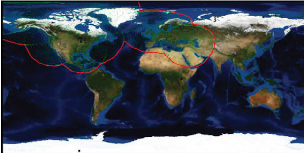
FIGURE 8.3 Denied access area contours. SOURCE: European Space Agency.
(It should be noted that no documented instances or reports of operating UHF radars actually having deleterious effects on incumbent services have come to the attention of the committee.)
L-Band
Band Usage
The IEEE Standard Letter Designations for Radio-Frequency Bands defines the L-band as between 1 and 2 GHz. The EESS-Active allocation at the L-band is from 1215 to 1300 MHz. The L-band has been extensively used for scientific remote sensing for many years. Because the L-band is insensitive to clouds and rain and offers a moderate level of vegetation and surface penetration, it is ideal for many scientific measurements, including soil moisture mapping, sea ice mapping, and soil moisture and biomass estimation. In addition to various environmental science applications, the L-band is also used for various civil applications, including detection of surface deformations associated with seismic and other natural hazards, land-use assessment, and crop characterization.
There is an expansive body of knowledge regarding the retrieval of geophysical data from radar measurements at the L-band, and a large technology investment in both airborne and spaceborne L-band systems. The first SAR to fly in space was an L-band system flown on Seasat in 1978. Successive L-band sensors have flown on both U.S. missions (SIR-A, 1981; SIR-B, 1984; SIR-C, 1994) and Japanese missions (JERS-1, 1992; ALOS/PALSAR, 2006; ALOS-2/PALSAR-2, 2014). Current or planned systems include the U.S. Aquarius, SMAP, and NISAR missions and the Argentine SAOCOM. In addition, numerous airborne L-band radars are operated around the world, including the NASA UAVSAR system.
Earth remote sensing systems share the L-band region of the spectrum with other important services worldwide. In the United States, the EESS allocation overlaps with radiolocation services (primarily ground-based Federal Aviation Administration (FAA) and Department of Defense air surveillance radars) as well as radio navigation satellite systems (GPS). Globally, the band is used by air surveillance radar and the radio navigation satellite systems of other nations, among others.
Interference Environment for Active Sensors at the L-Band
RFI is a well-known issue for science sensors operating at the L-band, particularly over the world’s developed population centers: North America, Europe, and East Asia (see Figure 8.4). Most of the interference over North America is from relatively narrowband pulsed emitters, indicative of ground-based radars (see Figure 8.5), but emissions over other regions of the world are indicative of different
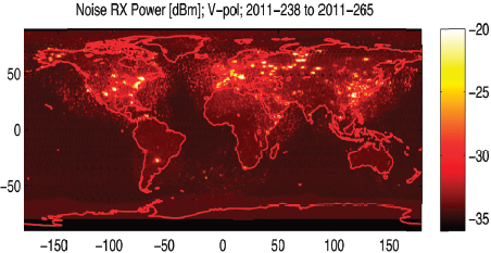
FIGURE 8.4 RFI observed by the Aquarius L-band instrument in 2011. The Aquarius radar operates in a 4 MHz band centered on 1260 MHz. Image courtesy NASA/JPL-Caltech.
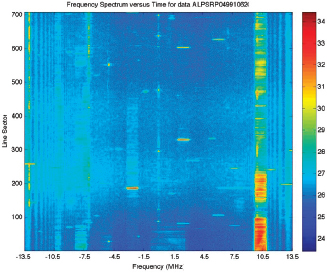
FIGURE 8.5 A time spectrogram of observed RFI taken from ALOS/PALSAR data. Frequencies are referenced relative to the PALSAR center frequency, which is 1270 MHz. Image courtesy NASA/JPL-Caltech and JAXA.
types of systems. Globally, the RFI environment at the L-band has been observed to be growing steadily worse with time. The Japanese Aerospace Exploration Agency (JAXA) conducted a study in which the percentage bandwidth contaminated by RFI from the JERS-1 mission, which flew in the 1992-1998 time frame, was compared to the same metric from the ALOS mission, which flew in the 2006-2011 time frame. JAXA found that significantly more of the spectrum was contaminated more of
the time during the ALOS mission. L-band airborne systems also routinely report observing RFI.2
L-band data are often sufficiently corrupted by RFI that science can be seriously compromised. Because of the importance of the L-band spectrum for many geophysical measurements, mitigation techniques for remote sensing radars are highly developed. For the JAXA L-band missions (previously, JERS-1 and ALOS/PALSAR, and now ALOS-2/PALSAR-2), these strategies are being implemented operationally as part of the ground radar processing and are seen as largely preserving the scientific quality of the data. Regions where RFI removal is successful share two primary characteristics:
- Relatively “sparse” time/bandwidth occupancy of the RFI. Many of the interfering systems are observed to be either narrow-band systems, whose energy can be notched out in frequency as part of the mitigation process, or pulsed sources with relatively low duty cycles, where time-domain detection and excision is effective at removing the offending events.
- Many sources that are observed to be quite stationary in geographical position and over long periods of time (months, years). This allows mitigation techniques to be finely tuned.
RFI mitigation techniques have enabled JAXA science objectives to be met over most of the globe. The NASA L-band SMAP and planned NISAR missions are planning to use similar techniques for RFI mitigation.
Though successful, it is important to point out that most of the RFI mitigation efforts at the L-band have been largely reactive in nature in that the interference environment was not fully understood until the sensor was in orbit. In the case of the JAXA sensors, for instance, it is fortuitous that both the design of the sensor and the precise nature of the interference environment have combined to allow RFI mitigation to be successful. Still, there are some regions of the globe where the RFI time/bandwidth occupancy of RFI is sufficiently “non-sparse”—that is, the environment is sufficiently populated with many emitters—that current RFI removal techniques are not effective. Noteworthy cases include some urban areas of East Asia. There is also concern that the band in general is filling up with more and more interferers, which are exhibiting increasingly “non-sparse” time/frequency characteristics. An example is the FAA’s deployment of the new Common Air Route Surveillance Radar (CARSR) system), which utilizes longer transmit pulses and a higher overall duty cycle and is consequently less sparse in time/frequency than predecessor systems.
___________
2 See Appendix C for more detail.
Transmit Restrictions for Active Sensors at the L-Band
Although L-band remote sensing systems have not experienced the severe transmit restrictions that have occasionally been imposed on P-band systems, they appear to be coming under increased scrutiny in the spectrum approval process. This is likely due to the fact that the L-band spectrum overall is becoming more crowded with time, and “incumbent” services such as air surveillance radars and global positioning systems are concerned about the potential negative impact of these spaceborne systems. Although no proposed spaceborne system has so far been denied the ability to operate, the burden of proof imposed on such systems to demonstrate that they will not adversely impact incumbent systems appears to be growing heavier in recent years. Examples include costly hardware design changes required for SMAP late in its development phase and certain operational restrictions requested for the PALSAR system. Airborne systems have likewise been impacted. For instance, although UAVSAR has generally not had difficulty operating over the United States, the full Stage 4 certification approval has nevertheless been delayed due to concerns of agencies that operate incumbent systems. Although these measures can be seen as justifiable means to demonstrate that critical incumbent services will not be interfered with, the perception of many in the science community is that the criteria for interference are often ill defined, and, consequently, extreme conservatism is invoked at the expense of science measurements. (Again, it is noted that no instances or reports of L-band science sensors actually having interfered with incumbent services have come to the attention of the committee.)
S-Band
Band Usage
The IEEE Standard Letter Designations for Radio-Frequency Bands defines the S-band as between 2 and 4 GHz. The EESS-Active allocation at the S-band is from 3.1 to 3.3 GHz, and it is a secondary allocation. The S-band is a good intermediate frequency that has many of the long-wavelength advantages of the L-band (good penetration of low vegetation, low temporal decorrelation, low tropospheric propagation losses), as well as some of the advantages of higher frequencies (smaller antennas, lower degree of ionospheric effects, ability to measure rain when operated at high power in ground-based applications). ESA’s ENVISAT mission utilized an S-band altimeter channel that operated over a bandwidth of 3.1-3.3 GHz in order to make ionospheric corrections for sea surface topography measurements. Otherwise, science users of this band spaceborne are primarily China, which is currently operating the HJ-1C SAR mission, and India, which plans to fly an S-band SAR on the joint ISRO/NASA NISAR mission to be launched around 2020. Whereas the
entire S-band region encompasses a variety of services—including radiolocation, spacecraft communication links, fixed and mobile communications, and radio astronomy—the 200 MHz EESS band overlaps a band currently allocated only for radiolocation systems.
Interference Environment for Active Sensors at the S-Band
No information regarding RFI experienced at the S-band has come to the attention of the committee. The ENVISAT S-band altimeter preprocesses its raw data onboard, so that all but the most extreme RFI is not likely to be easily seen in the downlinked data. Little information regarding the Chinese SAR observations has been available to the committee.
Transmit Restrictions for Active Sensors at the S-Band
No ongoing difficulties with spectrum access at the S-band have come to the attention of the committee.
C-Band
Band Usage
The IEEE Standard Letter Designations for Radio-Frequency Bands defines the C-band as between 4000 and 8000 MHz. The EESS-Active allocation for the C-band is from 5250 to 5570 MHz. The C-band is one of the most important bands for radar science imaging, and there has been substantial technological investment for the C-band by many of the world’s space and science agencies. The choice of the C-band offers a suitable compromise between the antenna aperture size required to achieve a desired beamwidth (which decreases with frequency) and the attenuation of the radar signal as it propagates through rain and clouds (which increases with frequency). The C-band is also used for Doppler weather radar, which detects the motion of rain droplets in addition to the intensity of precipitation. Examples of satellite SAR systems operating at the C-band include the Canadian Radarsat-1, which was launched in 1995, and Radarsat-2, which was launched in 2007. Canada’s next-generation Radarsat Constellation Mission (RCM) will be launched in 2018. ESA’s Sentinel-1 satellite was launched in April 2014. All of these SAR radars operate in the 5350-5470 MHz band. Examples of satellite ocean altimeter systems operating at the C-band include the French SSALT on JASON, which was launched in 2001, ESA’s Sentinel 3, which was launched in 2013, and the Chinese HY-2A, which was launched in 2011. Examples of satellite
ocean wind scatterometer systems operating at the C-band include ESA’s ASCAT on Metop, which is to be launched in 2016, and the Chinese FY-3E wind radar, which is to be launched in 2018. C-band ground-based weather radars operate in the primary radiolocation band of 5600-5650 MHz.
Interference Environment for Active Sensors at the C-Band
ESA reports a limited number of RFI events at the C-band in scatterometer and SAR data, although there is evidence that it is increasing. For SAR data, the RFI appears as short, strong bursts indicative of ground-based radar. As previously discussed, such events fall into the “sparse” time/bandwidth occupancy category, and the ESA experience is that they have (thus far) been readily mitigated to recover clean SAR imagery.
The biggest concern for C-band science radar interference is the proliferation of wireless access systems, which include radio local access networks (RLANs). At the World Radiocommunication Conference 2003 (WRC-2003), the decision was made to provide a primary allocation to the mobile service in the bands 5250-5350 MHz and 5470-5725 MHz. As a preventative measure, ESA and the Canadian Space Agency (CSA) chose to move their Sentinel, RadarSat-2, and RCM sensors to the band 5350-5470 MHz, which was not open to RLAN, in order to avoid RFI from such systems in the future. There has been a subsequent push by the wireless industry, however, for the addition of the 5350-5470 MHz band for RLAN use. ESA studies show that the RLAN deployment in the frequency band 5350-5470 MHz will create harmful interference to Sentinel-1 satellites, as well as Canada’s Radarsat-2 and RCM (three satellites). A major concern is that extension of mobile services to the 5350-5470 MHz band would eventually be applied worldwide. Studies by ESA and CSA suggest that no mitigation would be possible because the aggregated effect of the RLAN RFI is entirely different from that of “classical” (for example, pulsed, or narrowband) RFI experienced with SAR in that it appears as continuous, broadband, noiselike interference, and consequently is distinctively “nonsparse” in the time/bandwidth domain. The RLAN bands consist of 10 channels, each with 18 MHz of bandwidth. Figure 8.6 shows the frequency spectrum of a simulated 18 MHz RLAN signal.
As an interference mitigation approach, it has been proposed that radar and wireless access system (WAS) technologies will coexist in the same environment through a frequency abandonment protocol implemented in the RLANs. The RLANs are required to utilize dynamic frequency selection (DFS), whereby radio frequencies are monitored and the RLAN selects frequencies that are not in use. Before using a channel, the RLAN would check for the presence of radar signals. If any signal is detected, the RLANs would vacate the channel for a 30-minute period. In addition, before reusing the channel, the RLANs must continuously monitor
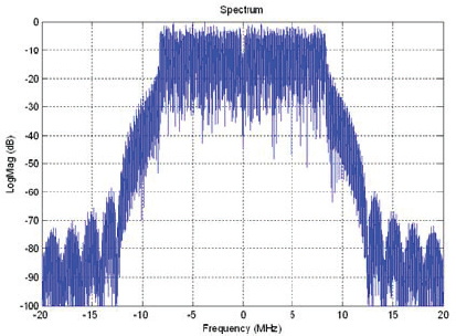
FIGURE 8.6 The frequency spectrum of a simulated 18 MHz RLAN signal.
the channel for 10 minutes. An analysis performed recently by ESA (presented in June 2014 at the SFCG-34 meeting in Boulder, Colorado) disputes the claim by the wireless industry that the RLANs can safely coexist with C-band SAR satellite radars using this method. An ESA analysis, presented under WTC-15 agenda item 1.1, indicates that even two outdoor RLANs in the active footprint of the radar will exceed the interference maximum defined in ITU-R RS 116-4. Furthermore, the expected density of RLANS in a suburban environment will exceed the maximum interference limit by over 24 dB. This presents a significant degradation to C-band SAR performance over major areas of coverage.
It has also been well documented that RLANs can severely interfere with the operation of ground-based weather radars. Early versions of the DFS algorithm used in commercial RLAN units were incapable of detecting the waveforms common to C-band Doppler weather radars. A detailed study was performed by NTIA on the interference of RLAN’s on the C-band WSR-88D weather radar in Puerto Rico. The study identified a set of problems with the commercial DFS implementations, which were remedied in subsequent versions of the RLANs.
Transmit Restrictions for Active Sensors at the C-Band
The ITU Radio Regulations have several footnotes at the C-band stating that the EESS-Active shall not claim protection from the radiolocation service in the 5250-5350 MHz band and that the EESS-Active shall not cause harmful interfer-
ence to the aeronautical service in the 5350-5460 MHz band, to the radio navigation service in the 5460-5470 MHz band, or to the maritime radio navigation service in the 5470-5570 MHz band. Compatibility studies with simulation results have shown that the EESS-Active does not cause harmful interference to the other services in the C-band. Overall, no ongoing difficulties with spectrum access at the C-band have come to the attention of the committee.
X-Band
Band Usage
The IEEE Standard Letter Designations for Radio-Frequency Bands defines the X-band as being between 8000 and 12000 MHz. The EESS-Active allocation for the X-band is 8550-8650 MHz and 9300-9900 MHz. The X-band is another important band for scientific radar imaging. Like the L-band and the C-band, the X-band is also extensively used for “applications,” including seismic hazard analysis, environmental disaster monitoring, and infrastructure assessment. Examples of satellite SAR systems operating at the X-band include the German two-satellite TerraSAR on Tandem-X, launched in 2007; the Italian five-satellite constellation COSMO-SkyMed, launched from 2007 to 2010; the Israeli TECSAR, launched in 2008; the Italian CSG, to be launched in 2015; the Spanish Paz SAR-X, launched in 2013; and the Russian Meteor-M SAR, to be launched in 2015. X-band science sensors share the band with terrestrial radio navigation radars and radiolocation tracking radars operating between 9300-9900 MHz.
Interference Environment for Active Sensors at the X-Band
Although some anecdotal discussion of RFI observed by X-band SAR came to the attention of the committee, this has not been reported to be much of a current problem. At least over North America, most of the current radio navigation and radiolocation radars at the X-band have either unmodulated pulses or frequency modulated pulses with relatively narrow bandwidths of 1 MHz or less. As previously discussed, mitigation techniques have been demonstrated for this type of interference at the L-band and the C-band.
Transmit Restrictions for Active Sensors at the X-Band
There are no known restrictions on spectral access for science sensors in the X-band. The pulsed radars of the EESS-Active are generally very compatible with the pulsed radars of the radio navigation and radiolocation service radars. Compat-
ibility studies with simulation results have shown that the EESS-Active does not cause harmful interference to the other services in the X-band.
Driven by the desire to achieve higher spatial resolution for science and applications, there is an Agenda Item (AI 1.12) for WRC 2015 to expand the EESS-Active from 600 MHz bandwidth to 1200 MHz bandwidth. This is proposed to be accomplished by expanding in a contiguous lower band, in a contiguous upper band, or in a combination of lower and upper bands. Although there has been interest in creating new allocations for EESS-Active in other regions of the spectrum, this proposal at the X-band represents perhaps the most significant near-term effort to expand the EESS-Active allocation rather than simply defend it.
Ku-Band and K-Band
Band Usage
The IEEE Standard Letter Designations for Radio-Frequency Bands defines the Ku-band as between 12000 and 18000 MHz. The EESS-Active allocations for the Ku-band are 13250-13750 MHz and 17200-17300 MHz. Most of the current EESS-Active systems operate in the 13250-13750 MHz band. (In previous years the Ku-band allocation was from 13400 MHz to 14000 MHz, but the upper band 13750-14000 MHz was taken from EESS-Active and given to satellite link usage, and at the same time the lower band 13250-13400 MHz was added to EESS-Active). The Ku-band is an important band for spaceborne altimeters, scatterometers, and precipitation radars, as well as many airborne systems making similar measurements on a more regional basis over the years. Examples of satellite altimeter systems operating at the Ku-band include the French SSALT on JASON, which was launched in 2001; ESA’s Sentinel 3, which was launched in 2013; and the Chinese HY-2A, which was launched in 2011. Examples of satellite scatterometer systems operating at the Ku-band include NASA’s Seawinds on Quickscat, which was launched in 1999; the replacement Rapidscat on the International Space Station, which was launched in 2014; the Chinese HY-2A scatterometer, which was launched in 2011; and the Chinese FY-3E wind radar, which is to be launched in 2018. Examples of satellite precipitation radar systems operating at the Ku-band include NASA/JAXA’s TRMM, which was launched in 1997, and NASA/JAXA’s GPM DPR, which was launched in 2014. The Ku-band is also being used for a relatively new measurement of snow depth and snow water equivalent by airborne systems. There is interest among European and U.S. investigators in deploying a snow measurement system from space that potentially would utilize the allocation 17200-17300 MHz band in space for the first time.
The IEEE Standard Letter Designations for Radio-Frequency Bands defines
the K-band as between 18000 and 26000 MHz. The EESS-Active allocation for the K-band is 24050-24250 MHz. There are currently no plans to operate an EESS-Active system in space at the K-band.
Interference Environment for Active Sensors at the Ku-Band and the K-Band
No reports of significant RFI at the Ku-band have come to the attention of the committee. It should be noted that Ku-band sensors that have been deployed to date have either (1) been primarily ocean missions and thus primarily concerned with areas away from land-based RFI sources or (2) performed significant amounts of onboard processing or averaging (in either time or frequency) that would tend to “wash out” any evidence of low to moderate RFI of the type typically observable in the “raw” data provided by SARs. It is largely unknown if future sensors seeking to make more sensitive measurements could observe RFI in the future, but that is certainly possible. Ku-band radar interference could come from aeronautical radio navigation radars operating in the 13250-13400 MHz band and radiolocation radars operating in the 13400-13750 MHz band and the 17200-17300 MHz band. An NTIA report indicates that emitters at the Ku-band show occupancy by high-power, long-range air search radars and terrestrial point-to-point communications.3
There is an Agenda Item (AI 1.6.1) for WRC 2015 to consider possible additional primary allocations to the fixed satellite service (Earth-to-space and space-to-Earth) in the 10-17 GHz range, which includes the EESS-Active band 13.25-13.75 GHz. There is also an Agenda Item (AI 1.6.2) for WRC 2015 to consider possible additional primary allocations to the fixed satellite service (Earth-to-space) in the 13-17 GHz range for Regions 2 and 3, which includes the EESS-Active band 13.25-13.75 GHz. Moreover, there is also an Agenda Item (AI 1.17) for WRC 2015 to consider possible spectrum requirements to support wireless avionics intracommunications (WAIC) in the EESS-Active band 13.25-13.4 GHz. These services represent a potential threat to science sensors either as future interference sources or as future spectral co-occupants that could impose transmit restrictions on active science systems. Sharing studies are being performed in the various ITU study groups including SG7 to protect the EESS-Active bands.
___________
3 F.H. Sanders, B.J. Ramsey, and V.S. Lawrence, Broadband Spectrum Survey at San Francisco, California May-June 1995, NTIA Technical Report TR-99-367, National Telecommunications and Information Administration, Washington, D.C., 1999.
Transmit Restrictions for Active Sensors at the Ku-Band and the K-Band
Although compatibility with existing services must always be established before flying any new sensor, no current significant barriers to operating active sensors at these frequencies have come to the attention of the committee.
Ka-Band
Band Usage
The IEEE Standard Letter Designations for Radio-Frequency Bands defines the Ka-band as between 26000 and 40000 MHz. The EESS-Active allocation for the Ka-band is at 35500-36000 MHz. The Ka-band is employed for altimeters, SARs, and cloud and precipitation radars. Multiple airborne systems exist to make these measurements for regional science or as demonstration platforms for space missions. Examples of satellite altimeter systems operating at the Ka-band include the French SARAL AltiKa, which was launched in 2012, and the U.S./French SWOT KaRIN, to be launched in 2020. A current example of a satellite precipitation radar system operating at the Ka-band is NASA/JAXA’s GPM DPR, which was launched in 2014. The use of the Ka-band is somewhat “young” relative to the lower frequencies discussed thus far. Because of the relatively compact electronics and antennas, as well as the sensitivity to atmospheric hydrometeors associated with this high RF, the Ka-band is expected to be a significant growth area, seeing more and more sensors flown in the near future.
Interference Environment for Active Sensors at the Ka-Band
No reports of significant RFI at the Ka-band have come to the attention of the committee. Like other frequencies, there are some known, very-high-power ground radars that Ka-band sensors must take care to protect themselves against. Similar to the Ka-band, many current sensors either predominantly operate over the ocean or significantly process the data onboard, making a characterization of low to moderate RFI difficult. As with the Ku-band, it is currently difficult to assess the prospects of future measurements with respect to RFI.
Transmit Restrictions for Active Sensors at the Ka-Band
There are some restrictions on transmitted signals for science sensors at the Ka-band. In particular, there are limitations on the mean power flux density at Earth’s surface that these sensors are allowed to produce in order not to interfere
with ground-based defense radars. Modern sensors (such as KaRIN on SWOT) meet this criterion, but not with a large amount of margin, perhaps suggesting that significant operational limitations may exist if the science community wishes to employ higher-power or higher-gain systems in the future.
W-Band
Band Usage
The IEEE Standard Letter Designations for Radio-Frequency Bands defines the W-band as being between 75000 and 110000 MHz. The EESS-Active allocations for the W-band are 78000-79000 MHz and 94000-94100 MHz. The W-band is used primarily for cloud profiling radar (CPR) systems. Examples of satellite CPR systems operating at the W-band include the U.S. CloudSat mission, which was launched in 2012, and ESA/JAXA’s Earthcare CPR, which is to be launched in 2015, both of which operate within the 94000-94100 MHz band. The committee is unaware of any EESS-Active system planned for the 78000-79000 MHz band.
Interference Environment for Active Sensors at the W-Band
W-band radar interference could potentially come from radiolocation radars operating in the 78000-79000 MHz band and the 94000-94100 MHz band. Operators of CloudSat have not reported any RFI issues.
Transmit Restrictions for Active Sensors at the W-Band
There are restrictions on spectral access for science sensors in the W-band related to possible interference with radio astronomy (a passive radio science technique). An ITU Radio Regulations footnote states that “the use of the band 94-94.1 GHz by the Earth exploration-satellite (active) and space research service (active) is limited to spaceborne cloud radars.” This apparently means that other applications at the W-band are allowed only in the lower W-band at 78-79 GHz, a potentially limiting restriction. Another Radio Regulations footnote (5.562 A) states that because W-band transmissions at 94 GHz from space “have the potential to damage some radio astronomy receivers … space agencies operating the transmitters and the radio astronomy stations concerned should mutually plan their operations so as to avoid such occurrences to the maximum extent possible.”
Millimeter-Wave Band
Band Usage
The IEEE Standard Letter Designations for Radio-Frequency Bands defines the millimeter (mm)-band as between 110000 and 300000 MHz. The EESS-Active allocations for the mm-band are 133500-134000 MHz and 237900-238000 MHz. These bands have been proposed for possible spaceborne use for more sensitive cloud radars, but no satellite remote sensing EESS-Active system currently operates in this spectral region. These bands, however, are a potential new frontier for science sensors, and there is danger of potentially losing these bands to other services if they are not used.
Interference Environment for Active Sensors at the Millimeter-Band
Interference in the mm-band could potentially come from fixed, intersatellite, and mobile service systems operating in the 133500-134000 MHz band.
Transmit Restrictions for Active Sensors at the Millimeter-Band
There are restrictions on spectral access for science sensors in the mm-band. The lower mm-band at 133.5-134.0 GHz falls into the 130-134 GHz band, where the radio astronomy service has a primary allocation. The upper mm-band at 237.9-238.0 GHz band falls into the 235-238 GHz band, where the EESS (passive) has a primary allocation. There is a restriction similar to the W-band for “spaceborne cloud radars only” for the upper band 235-238 GHz. There is no such restriction in the lower band at 133.5-134.0 GHz, where the radio astronomy service has a primary allocation, but for this lower band the mutual planning of operations would avoid damaging radio astronomy receivers.
Finding 8.1: There are primarily two spectrum issues that can impact active science sensors. Like passive sensors, active sensors can experience RFI from other radio services. Conversely, and unlike passive systems, active systems also transmit signals and are hence subject to operational restrictions to ensure that they do not interfere with other services. With demand for and use of the spectrum growing rapidly, both of these spectrum issues are generating concerns for the successful operation of current and planned active science sensors.
Finding 8.2: In several cases, transmit restrictions imposed on active science sensors have significantly impeded the ability to collect the desired science data (as in the operational restrictions imposed on ESA’s BIOMASS mission), degraded the science data (an example being the deep spectral waveform notches required on the GeoSAR sensor flown on aircraft), or significantly driven up costs (as for the NASA Soil Moisture Active-Passive mission). Conservative interference standards in some bands can make science operations difficult. Restrictions imposed in the lower-frequency UHF and L-bands are increasing with time.
Finding 8.3: Whereas active science sensors routinely report interference from other nonscience sources, science sensors appear to rarely interfere with other services. The only documented instance to come to the attention of the committee of an active science sensor actually interfering with the operations of another service was the CloudSat radar, which can interfere with the radio astronomy service (another science service).
Finding 8.4: The RFI environment has been observed to be growing worse in some bands. Within the heavily used and well-studied L-band allocation of 1215-1300 MHz, the amount of RFI observed worldwide has steadily increased over time. This trend has been detected by a series of L-band SARs operated by JAXA spanning the years 1992-2011. ESA has reported an increase in RFI at the C-band.
Finding 8.5: As of yet, few problems with RFI have been experienced with the specific science measurements made at frequencies above the C-band.
Finding 8.6: RFI mitigation techniques have been successfully employed at the UHF, L-, and C-bands to significantly reduce the impact of interference on science. Current RFI mitigation techniques, however, work best for interfering signals that have “sparse spectral/temporal occupancy” (e.g., signals closest to being continuous wave or short, widely separated pulses). The more that sources, or aggregates of sources, resemble broadband white noise, the more difficult the interference is to mitigate with known techniques. Consequently, active remote sensing is able to more effectively share with some services than others.
Finding 8.7: Established, high-value science radar measurements at the C-band face near-term threats due to the planned expansion of commercial services in the EESS-Active allocation. The proposed 5350-5470 MHz
RLAN service will severely limit science performed by ESA’s Sentinel 1 satellite and Canada’s Radarsat-2 and RCM constellations. The broadband, noiselike nature of RLAN emitters is difficult or impossible to mitigate.
Finding 8.8: Particularly for spaceborne missions, the RFI environment is difficult to characterize a priori for a given instrument. Consequently, RFI measures are often only fully implemented reactively when the true nature of the interference environment is encountered after a new sensor is deployed. This is due to both the incompleteness of information regarding current emitters worldwide and the evolving nature of the RFI environment over time.
Finding 8.9: There is currently a lack of good metrics for quantifying the degradation of science measurements for the full variety of active instrument types (for example, scatterometers, altimeters, synthetic aperture radars, interferometers, sounders, and others). This, coupled with Finding 8.7, often makes it difficult to predict accurately how a given active sensor might be impacted by RFI, how the RFI might be mitigated, and how the spectrum might be shared.
Finding 8.10: There are multiple bands allocated to EESS-Active where only portions, of the band are being used or that are not being used at all. With constant pressure to accommodate new services, it may be more difficult to establish new science in these bands in the future.
Recommendation 8.1: NASA should lead an effort to significantly improve characterization of the radio-frequency interference environment that affects active science measurements. This effort should also involve other agencies involved in active remote sensing, including the National Oceanic and Atmospheric Administration, the National Science Foundation, and perhaps the Department of Defense, as well as the agencies regulating these activities—the Federal Communications Commission and the National Telecommunications and Information Administration. The effort could be coordinated by the Office of Science and Technology Policy. It should include the use of (1) modeling, (2) dedicated ground-based and airborne characterization campaigns, and (3) data mining of currently operating science sensors. To the extent possible, this effort should be a collaborative one with other space and science agencies of the world.
Recommendation 8.2: NASA should lead a community effort to construct a set of metrics that relate the various radio-frequency interference environments encountered to the associated degradation in science performance for each major class of instruments employed in active remote sensing.


