
![]()
The U.S. Army Corps of Engineers Navigation Data Center provides publicly available waterborne commerce data that can be used to indicate commodity corridors. The committee’s analysis indicated eight major commodity corridors with partially overlapping usage of rivers and navigation infrastructure: two food and farm corridors, one coal energy corridor, three corridors for petroleum and chemicals, one crude materials corridor, and one manufactured goods corridor. The corridors are listed below and shown in Figure B-1 and Figure B-2.
- Coal corridor: Ohio River system, including the Allegheny and Monongahela Rivers;
- Food and farm corridor: Upper Mississippi and Illinois Rivers to New Orleans, Louisiana;
- Petrochemical corridor: Mississippi River from Saint Louis, Missouri, to New Orleans;
- Manufactured goods corridor: Mississippi River from Saint Louis to New Orleans;
- Crude materials corridor: Ohio and Upper Mississippi Rivers (from Saint Louis) to New Orleans;
- Food and farm corridor: Columbia River system, including Columbia, Snake, and Willamette Rivers;
- Chemical goods corridor: Gulf Intracoastal Waterway (GIWW); and
- Petroleum goods corridor: GIWW.
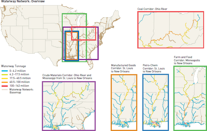
FIGURE B-1 Major commodity corridors on the inland waterways trunk (Mississippi, Illinois, and Ohio River systems), 2011. (IWWN = inland waterway network.)
SOURCE: U.S. Army Corps of Engineers Navigation Data Center GIS Viewer files (http://www.navigationdatacenter.us/db/gisviewer, file linktons11.zip, accessed July 2014).
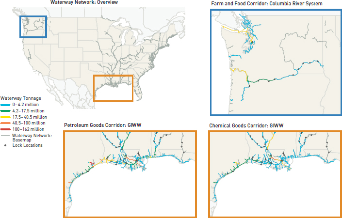
FIGURE B-2 Columbia River and GIWW corridors, 2011.
SOURCE: U.S. Army Corps of Engineers Navigation Data Center GIS Viewer files (http://www.navigationdatacenter.us/db/gisviewer, file linktons11.zip, accessed July 2014).


