
By the late 1980s, the scientific disciplines that had for the most part independently studied Earth’s atmosphere, oceans, land, cryosphere, and ecology recognized the need to conceptualize Earth as an interactive set of systems, affected both by human activities and natural changes. These processes and their interactions, illustrated by the “Bretherton diagram” (NAC, 1986) in a set of reports led by geophysical fluid dynamicist Francis P. Bretherton, elucidated the concept of Earth system science.1 The mid- to late-1980s were also the period when, as part of its contribution to a multiagency response to the challenge of understanding Earth as an integrated system of interacting components, NASA initiated the Earth Observing System (EOS) program.2 The EOS program culminated in the launch of its flagship Terra, Aqua, and Aura facility-class spacecraft in 1999, 2002, and 2004, respectively.3 Since then, a set of Earth System Science Pathfinder4 and Earth Systematic Missions5 have also been successfully launched including Aquarius, CALIPSO, CloudSat, GRACE, OCO-2, SMAP,6 the Jason series of ocean surface topography satellites; and GPM. Two other spacecraft—GLORY and OCO—were completed but lost due to launch failures.
The first Earth science and applications from space decadal survey (NRC, 2007), initiated in 2005, was organized thematically, dividing Earth system science into the following topics: weather science and applications; climate variability and change; land-use change, ecosystem dynamics, and biodiversity; water resources and the global hydrologic cycle; solid-Earth hazards, natural resources, and dynamics; and human health and security. Study panels in each of these areas prioritized candidate missions that would address new or continuing mea-
______________
1 Excerpted from CIESIN (2013).
2 First person accounts of the history of the EOS program may be found in NASA (2008).
3 Also launched during this period with funding from the EOS program were ICESat, Landsat 7, QuikScat (Quick Scatterometer), ACRIMSat (Active Cavity Radiometer Irradiance Monitor Satellite), Jason-1, SAGE III (Stratospheric Aerosol and Gas Experiment-III), and SORCE (Solar Radiation and Climate Experiment).
4 The ESSP program also encompasses NASA’s Earth Science Division’s NASA’s Earth Venture (EV) class of missions: a series of uncoupled, relatively low-to-moderate cost, small to medium-sized, competitively selected, full orbital missions (EVM), instruments for orbital missions of opportunity (EVI) and suborbital projects (EVS), legacy ESSP Projects. See NASA (2015).
5 NASA “Earth Systematic Missions,” http://science.nasa.gov/about-us/smd-programs/earth-systematic-missions, accessed April 6, 2015.
6 SMAP (Soil Moisture Active-Passive) is the successor to the ESSP Hydros (Hydrosphere State) mission, which was cancelled by NASA due to budget constraints in late 2005.
surement needs; however, a satisfactory scheme to value candidate missions/measurements across these themes was not established.7 The next decadal survey in Earth science and applications from space, which is scheduled to begin in 2015, will confront this problem anew, exacerbated by the increasing number of measurements that are candidates for continuation and the large number of missions remaining in the queue of the previous decadal survey. Figure 2.1 illustrates the scale of the problem; it shows NASA Earth Science Division (ESD) missions currently in operation or in an advanced stage of planning. Table 2.1 shows ESD missions that might be in operation over the next 20 years.
The current and potential future NASA missions respond to the challenge of understanding the integrated Earth system globally in the pursuit of knowledge to address pressing societal needs—for example, weather and climate prediction; climate change impacts; the health of ecosystems; adaptation and protection from natural hazards. In general, they are also aligned with the Administration’s overarching emphasis on climate research and monitoring while being consistent with and informed by the 2007 NRC decadal survey.
While recognizing the preeminent importance of climate science in NASA’s Earth science programs,8 the committee also appreciates that ESD programs are shaped by consideration of a wide range of measurements for societal benefit, directly and indirectly, through increased scientific knowledge aiding projections made with Earth system models. Thus, the committee’s analysis framework considers the requirement for suites of observations that will be assimilated into Earth system models for assessing the threats to society from climate change and the projection of key processes affecting society in the future. Addressing this challenge requires identifying the key components of the Earth system that affect a particular process (e.g., sea level rise, water balance, carbon cycle, etc.) and maintaining a “system science” approach (e.g., how do these measurements improve the overall projections).
The task of the present study focuses on evaluating the benefit of continued measurements after an initial implementation and analysis. It is presumed that the measurement period is beyond a single mission; therefore, in a capped budget environment, its continuation is at the expense of alternative competing missions and measurements. In developing a decision framework suitable to value competing choices in a tightly constrained fiscal environment, the committee began with the following questions:
- What are the quantifiable science objectives that are important and amenable to study with the synergy of the various existing measurements and models?
- What are the needs for, and definitions of, continuity with respect to each measurement and with respect to understanding global change?
- What are the temporal, spatial, and accuracy requirements for such measurements, whether they be current or proposed?
- Are there alternate approaches to meeting the measurement requirements with acceptable performance and/or reduced costs?
The answers to these questions provide a basis for prioritization across candidate continuity measurements and a framework and rationale for development of new measurement techniques. In the rest of this chapter, the committee provides its definition of continuity, including defining those aspects of a measurement that are important for continuity. The framework itself is presented in Chapter 3.
______________
7 Each panel first set priorities among an array of space-based measurement approaches and mission concepts by applying the criteria shown in Chapter 2 of NRC (2007). Recommendations in previous community-based reports, such as those of the World Meteorological Organization, were also considered. The complete set of high-priority observations and missions identified by the panels numbered about 35, a substantial reduction from the more than 100 possible missions suggested in the responses to a broadly distributed “request for information,” but more than a factor of two beyond what could be accommodated even with the assumed budget that grew by more than $5 billion during the decadal survey interval. Prioritizing across the panels was the responsibility of the steering committee of the decadal survey, which referred to criteria similar to that employed by the panels; the steering committee prioritization was also informed by a separate study panel, the Panel on Earth Science Applications and Societal Benefits.
8 “The Obama Administration is acting on its recognition that climate change is a defining issue of our generation. Our responses to the challenges of climate change—accurate prediction, equitable adaptation, and efficient mitigation—will influence the quality of life for the nation, and indeed the world, for generations to come” (NASA, 2010, p. 2).
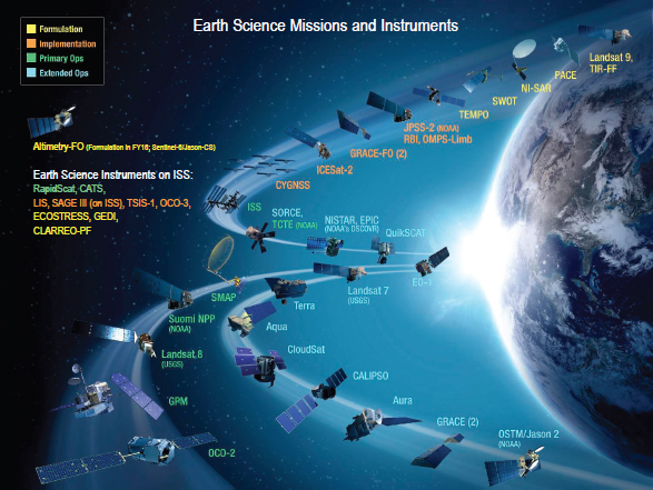
FIGURE 2.1 NASA Earth Science Division Missions and Instruments as of September 2015. NOTE: This figure reflects the following recent developments: the Tropical Rainfall Measuring Mission (TRMM), launched on November 27, 1997, stopped data collection on April 8, 2015, after the spacecraft depleted its fuel reserves and began a descent into Earth’s atmosphere that ended destructively on June 15, 2015; Aquarius launched on June 10, 2011, ceased operations on June 8, 2015, following a hardware component failure that resulted in a loss of onboard power regulation and spacecraft attitude stabilization; the radar on SMAP (Soil Moisture Active-Passive) stopped transmitting on July 7, 2015, due to an anomaly involving its high-power amplifier, although its radiometer continues to operate normally. SOURCE: Image courtesy of NASA Goddard Space Flight Center.
2.2 CONTINUITY: A WORKING DEFINITION
Scientific understanding of global change requires long-term, reliable measurements of the key physical variables that define the variability and shifts in state of the Earth system and its multiple components (see Box 2.1 for the committee’s definition of measurement and several other terms used in this report). Without such observations of the climate system, predictions of the complex responses of the Earth system to human activities and natural variations lack the certainty needed to plan and prepare for climate change.
For any particular climate system variable, the requirements for the duration of an observing record can be determined if there is an adequate understanding of the expected natural variability and its coupling with other forced components of global change. Unfortunately, these aspects of the climate system are often uncertain until a long-term, continuous record is acquired.
For some variables, NASA pursues the construction of climate-quality records from requisite measurements made from the vantage point of space. For example, instruments placed on satellites in appropriate orbits measure total solar irradiance, ozone (total column and vertical profile) and global temperatures in the lower atmosphere—with attention to issues of calibration (and bias) uncertainty and repeatability—enabling the development of consistent, global time-series at appropriate spatial and temporal scales not otherwise available. For other variables,
TABLE 2.1 Future NASA Earth Science Missions (as of 2014)
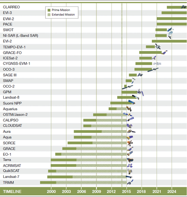
NOTE: The Tropical Rainfall Measuring Mission (TRMM) and Aquarius ceased operations in April and June of 2015, respectively. The extended missions depicted in Table 2.1 are approved for continued operations based on a senior peer review conducted by scientists every 2 years to determine the scientific value and priority of further mission extensions. Not shown are mid-2014 selections in the Venture-class: GEDI (Global Ecosystem Dynamics Investigation) and ECOSTRESS (Ecosystem Spaceborne Thermal Radiometer Experiment on Space Station). See “NASA Selects Instruments to Track Climate Impact on Vegetation,” press release, July 30, 2014, http://www.nasa.gov/press/2014/july/nasa-selects-instruments-to-track-climate-impact-on-vegetation/#.VUOqG_lVhBc.
SOURCE: NASA (2014).
BOX 2.1
Definition of Terms
This report uses a number of relatively common Earth science terms whose meaning is context-dependent. For clarity, the committee adopts definitions similar to those of the World Meteorological Organization (WMO) Committee on Earth Observing Satellites (CEOS) (i.e., Definitions and Requirements from the WMO/CEOS database–2009 draft1), but modified to be consistent with NASA’s Data Processing Level descriptions. Definitions of the terms used in this report are as follows:
- Geophysical phenomenon. A natural event or scene involving one or more geophysical variables.
- Geophysical variable. One of a set of measurable factors that define a geophysical phenomenon and determine its behavior. In this report, it is equivalent to the term “Geophysical Parameter.” Note: “Essential Climate Variables” (ECVs; see footnote 11) represent a subset of Earth system geophysical variables.
- Measurement. A quantitative record of a geophysical variable obtained by appropriate processing and comparison to standards of instrumental observations of geophysical phenomena. In this report a measurement is equivalent to the phrase “derived geophysical variable” used in the NASA Data Processing Level Descriptions (Level 2).
- Instrument. A device with suitable characteristics for deriving a geophysical variable measurement from observations of geophysical phenomena. In this report the data record from an instrument is equivalent to the term “Instrument Data” used in the NASA Data Processing Level Descriptions (Level 1).
______________
1 World Meteorological Organization (WMO) Committee on Earth Observing Satellites (CEOS), “Definitions and requirements from the WMO/CEOS Database - Draft, 13 October 2009,” http://portal.opengeospatial.org/files/?artifact_id=38204.
like the evolution of well-mixed greenhouse gases, surface-based measurements may provide sufficient data. For highly heterogeneous phenomena such as the effects of tropospheric aerosols on climate, satellites are needed to provide the necessary global maps and integrated impacts. Successful support of climate applications from satellites requires a strategy to provide for the essential characterization of the measurements: instrument calibration uncertainty, repeatability, time and space sampling, and data systems and delivery for climate variables (algorithms, reprocessing,9 and availability).
Many geophysical variables related to societal needs and goals vary naturally on long time scales (decades to centuries) and all spatial scales. The differences between human-forced changes and natural variability are difficult to detect until the former emerge above the natural variability of the climate system, usually after a decade or more of measurements (Bindoff et al., 2013). A current example is the slowdown (“hiatus”) in global mean surface warming over the past 15 years (Flato et al., 2013, Box 9.2). Detecting small, gradual changes requires well-calibrated, stable measurements made over long periods. Whether from remote sensing or in situ observations, it has proven extremely difficult to satisfy these measurement requirements over the decades necessary to resolve low-frequency variability in Earth’s environment. Subtle shifts in instrument calibration and performance and changes in processing can be mistaken for natural variability or anthropogenic change in the Earth system. Thus, it is necessary to maintain the ability to carry forward the science information essential to reconstruct a consistent time series of a geophysical variable from various instrument data sets. Reprocessing of instrument data acquired in the past is typically a necessary component for developing consistent climatological time series.
______________
9 For more on reprocessing and reanalysis, see Bosilovich et al. (2013).
Ensuring continuity of a geophysical variable from a sequence of “improved” instruments, or from copies of the same instrument, requires a careful program of instrument calibration, characterization, cross-comparison, and validation. Satellite instruments present particularly difficult challenges for the development of long-term, well-calibrated time series at any spatial scale because once on orbit they are no longer amenable to regular, repeated laboratory calibration and characterization. In operational programs, copies of instruments have been flown multiple times with the goal of simplifying this process. Although copies do not eliminate the need for calibration, characterization cross-comparisons, and validation, such an approach—including strategic group procurements of instruments or spacecraft—can reduce costs and typically reduce the risk in providing a long-term continuous record.
In addition to the basic instrument measurement, an adequate total observing system comprises platform orbital characteristics, instrument calibration tracking, data-processing algorithms, auxiliary data sets, and numerical models to derive geophysical data products. Changes in platform observing characteristics (altitude, orbit crossing times, etc.) introduce perturbations into the entire system. Development of calibration methods through satellite mission overlaps and surface-based overlapping measurements directly traceable to the National Institute of Standards and Technology (NIST) or other standards is necessary to provide reliable long-term measurements of geophysical variables.
In summary, the generation of a high-quality data set requires measurements made by well-characterized, calibrated, and stable instruments, validated algorithms, and consistent auxiliary data. In turn, this requires an assessment of instrument uncertainty and repeatability, temporal and spatial sampling, consistent algorithms, and provision for data reprocessing. With this in mind, the committee finds that the following is a sufficient high-level definition of continuity across the Earth science subdisciplines for use in an analysis framework focused on scientific objectives:
Finding: Continuity of an Earth measurement exists when the quality of the measurement for a specific quantified science objective is maintained over the required temporal and spatial domain set by the objective. The quality of a measurement is characterized by its combined standard uncertainty, which includes instrument calibration uncertainty, repeatability, time and space sampling, and data systems and delivery for climate variables (algorithms, reprocessing, and availability)—each of which depends on the scientific objective.
The committee identifies below four criteria—instrument calibration uncertainty, repeatability, continuity, and data systems and delivery—necessary for determining whether a data set has the requisite quality for long-term Earth observations and global change research. These criteria are fundamental to the framework introduced in Chapter 3 associated with the “quality” characteristic.
2.2.1 Instrument Calibration Uncertainty
To achieve a long-term record of a climate variable with acceptable uncertainty for use in Earth system science, it is essential to calibrate the instrument before flight, monitor the calibration changes in orbit, and, in many cases, cross-calibrate and monitor similar, but not necessarily identical, instruments. The uncertainty requirement for the measurement of a particular variable is determined by the variable’s signal magnitude, the expected temporal and spatial variability, and the requirements of the quantified science objective.
It is extremely difficult to calibrate an instrument to make measurements with sufficiently small uncertainty that climate change detection is possible without overlap to remove calibration bias. Instrument calibration methodology must be consistent across multiple instruments. An ongoing commitment to on-orbit calibration and characterization is essential in a continuity mission to assess the stability (or not) of the initial calibration. By providing instrument cross-calibration and in-flight calibration tracking validation, Earth observation data from NASA and national and international partners complement and add to the observations provided by other systems. As these data records are extended, merging them with retrospective data acquired by earlier satellites leverages their utility for climate change studies, but typically requires additional reprocessing as new measurements elucidate new understanding of the behavior of the instruments that acquired the earlier measurements.
A lack of careful and comprehensive calibration—with attendant large measurement uncertainty—substantially limits the value of the merged long-term data record, and decreases its value to the scientific enterprise. Detecting and characterizing change in relevant Earth system properties by comparing data from different instruments becomes difficult, if not impossible. Examples can be found in such basic measurements as the energy output of the sun, sea surface temperatures, total ozone columns, the global cloud cover and energy balance, and sea level changes. Good-practice approaches to instrument calibration that incorporate NIST-traceability are necessary to prevent incorrect scientific inferences from comparisons and analyses of measurements whose disparate uncertainties render them incompatible.
Historically, space-borne Earth observation instruments have been designed to achieve the necessary sensitivity and resolution for studying rapidly changing Earth processes and relatively fine spatial and temporal scales, such as weather systems. When considering program costs, absolute calibration of these instruments was a secondary consideration to their sensitivity. Recently, there has been an increased focus on the use of space-based global observations to understand climate change. However, major radiometric calibration challenges exist for instruments measuring, for example, atmospheric temperature (microwave and infrared sounders), cloud properties (reflected solar and infrared imaging radiometers), radiation budget (broadband scanning radiometers), ozone (back-scattered ultraviolet radiometer), and other geophysical variables that are key indicators of climate and global change (Myhre et al., 2013; NRC, 2007).
In lieu of the calibration uncertainty needed to detect climate change without overlapping measurements, most instruments in orbit attempt to use overlapping observations to cross-calibrate successive instruments with each other and then attempt to estimate instrument calibration stability over its lifetime (see Box 2.2 for an example for total solar irradiance observations). But constraints on stability for most instruments remain problematic. Over instrument lifetimes of 5-10 years on orbit, drifts in measurement bias occur due to contamination and degradation of materials in orbit (NRC, 2013; Loeb et al., 2007). The challenge is especially severe for reflected solar radiometers where calibration changes can reach 3 to 5 percent of the mean signal over the instrument lifetime—changes that are larger than the decadal climate change of interest.
BOX 2.2
Radiometric Uncertainty
Methods for constructing rigorous requirements have been developed for climate change observations (e.g., Leroy et al., 2008; Wielicki et al., 2013; NRC, 2013). For example, in the context of key science questions on cloud feedback with global warming, the reflected solar energy has a required uncertainty of 0.3 percent relative to laboratory standard of the reflected solar radiation (95% confidence). In the context of surface temperature trends, the required uncertainty is 0.07 K in brightness temperature (95% confidence). These uncertainties are a factor of 5 to 10 more stringent than typical for current Earth observations from reflected solar and infrared radiometers. Further detail of these methods can be found in Section 4.3 and Appendix C (e.g., Figure C.1).
This challenge was recognized by the first Earth science decadal survey (NRC, 2007), which proposed a mission called CLARREO (Climate Absolute Radiance and Refractivity Observatory) to serve as an in orbit National Institute of Standards and Technology-traceable set of spectrometers covering the entire reflected solar and thermal infrared. These spectrometers would provide an orbiting cross-calibration standard for 30 to 40 Earth-viewing instruments covering radiation, temperature/humidity profiles, sea surface temperature, cloud properties, aerosols, land processes, and ocean biosphere measures. The CLARREO mission remains under study, but represents a new way to bring a host of struggling earth science records up to future climate quality. Recent international studies (Goldberg et al., 2011; Dowell et al., 2013) have recommended such a system in orbit. Having on-orbit, long-term cross-calibration for the range of active satellites measuring the radiation budget would allow rigorous determination of instrument calibration drifts as well as allow crossing instrument gaps without inducing large uncertainty in climate change records.
Thus, critical questions are the following: What calibration uncertainty is required for the specific climate change objective being investigated? What is the point of diminishing returns? How do we decide if a measurement needs to be continued as is (with or without overlap), or needs improved accuracy for climate change? Box 2.2 provides an example of constructing requirements for radiometric uncertainty. Further examples in Chapter 4 and the appendixes demonstrate methods to quantify the different levels of accuracy achieved with and without continuity of observations.
The detection of trends in climate variables in the presence of real temporal and spatial variability requires observations with acceptable calibration uncertainty and repeatability over a long period of time. Acquiring a multi-decadal record is generally beyond the scope of a single satellite-instrument mission, thereby requiring multiple launches of space-qualified instruments. To answer climate change questions, these longer-term records are important for separating trends in the presence of larger seasonal and decadal variations. In general, there is a requirement for near-continuous observations without significant breaks that might miss the variability or step-trend that needs to be characterized. The sampling interval, as well as whether there can be an acceptable break in the measurement, depends on the relative magnitudes of the seasonal, decadal, and trend components of the signal. In the case in which there are diurnal variations due to clouds or diurnal heating of the surface, for example, the replacement sensors should observe at nearly the same time (if sun-synchronous) to avoid aliasing diurnal variations into other temporal changes.
Even with overlapping observations, it is still difficult to achieve climate change detection unless the repeatability of the measurement is sufficiently high. Repeatability relates to the consistency of time series of measurements of a given geophysical phenomena with the same or similar instruments. Repeatable measurements may not be accurate; for example, as a result of systematic error, or bias, that may be poorly known, or as a consequence of the random error, or noise,10 in a measurement that cannot be fully accounted for, but an accurate measurement (i.e., one with small uncertainty) will be repeatable. If the instrument lacks precision (i.e., repeatability on short time scales) the resultant noise can affect long-term repeatability. For example, the acquisition of reliable climate variables with acceptable repeatability (e.g., a factor of 10 less than its expected, forced change) leads to a critical need to perform intra-system and inter-system comparisons of individual measurements made for global change research, monitoring, and attribution. This strategy may require at least two similar or identical instruments to be in orbit at the same time, although not necessarily in the same orbit or observing the Earth system at the same time.
For many space-based instruments, however, demonstration of repeatability will require observations matched in time, space, and satellite viewing angle. The Global Space-based Intercalibration System (GSICS) provides an extensive literature of such studies (Goldberg et al., 2011). Instrument overlap enables comparisons of the calibration, performance, and idiosyncratic characteristics of different observing systems, knowledge of which is crucial for establishing the degree of measurement repeatability.11 In some cases, ground or suborbital observations may be able to provide a measure of calibration consistency (albeit with larger uncertainty) across multiple satellite instruments. Or it may be that overlap of similar instruments is required to achieve the needed repeatability (Box 2.3)—this leads to the requirement that a follow-on instrument be launched before, not after, the failure of the replaced instrument.
______________
10 Noise is often distinguished from bias by requiring that it refer to errors that have a zero mean value.
11 Relying on measurement repeatability alone to achieve the needed long-term climate observations requires that instrument overlap be assured and the overlapping data record be rigorously compared. To date, the primary example of this is the record for total solar irradiance. Many other climate records struggle with either high probability of overlap (radiation budget from ERBE (Earth Radiation Budget Experiment) to CERES (Clouds and Earth’s Radiant Energy System), for example) or rigorous demonstration of stability (for example against international standards). The 33-year multisatellite altimeter data record, which was initiated by the TOPEX/Poseidon mission, is an example where these considerations are important. The committee’s proposed framework is sufficiently flexible to consider both options because both quality and success probability are quantitatively considered. If repeatability can be demonstrated, and is required to attain the quality metric, then the success probability metric can be used to assess the likelihood that the proposed observing system will achieve overlap.
BOX 2.3
Repeatability of Total Solar Irradiance Measurements
The Sun is the primary energy source for Earth, and changes in solar irradiance force changes in climate. Once considered constant, total solar irradiance (TSI) is now known to vary continuously with solar activity. Measurements made by space-based solar radiometers have recorded increases of 0.1 percent from the minimum to the maximum of the Sun’s 11-year activity cycle. Historical proxy indicators of solar activity indicate that changes in TSI, averaged over the solar cycle, may exceed those within the 11-year cycle—that is, TSI changes larger than 0.1 percent may be possible on multi-decadal to century time scales.
The requirement for the solar irradiance climate record is that the measurements have the repeatability to detect a change in TSI over 50 years to within 0.75 W m-2 (NRC, 2013, Box 2.2). The absolute value of TSI during solar minimum is 1360.8 W m-2, so the corresponding climate requirement is a repeatability of 0.01 percent (100 ppm) per decade.1 Comparison of different TSI measurements made by individual space-based radiometric instruments during the 35-year record indicates uncertainties in the range 2 to 4 W m-2 (0.1-0.3 percent). Because the absolute calibration uncertainties of these measurements exceed the repeatability requirement (by more than a factor of two) it is not possible to achieve a solar irradiance climate record with the needed repeatability without cross-calibration of the radiometric scales of individual solar instruments. Securing this cross calibration requires overlap of the individual measurements.
By virtue of in-flight sensitivity tracking, for example with redundant radiometric cavities having different duty cycles, the repeatability of individual TSI measurements significantly exceeds the uncertainties. Comparisons of drifts among independent measurements during periods of overlap during the 35-year record suggest repeatability that are of order 15 ppm per year but can reach 40 ppm per year. Composite records constructed by cross calibrating individual measurements suggest that the extant 35-year TSI climate record has a repeatability of order 100 ppm per decade, determined as the drift between two independent composite records from 1979 to 2013 (Figure 2.3.1).
The TSI record in the most recent decade is more certain and has higher repeatability than does the record of the prior two decades. This is because of the deployment of the newly designed, characterized, and calibrated state-of-the-art Total Irradiance Monitor (TIM) on the Solar Radiation and Climate Experiment (SORCE) spacecraft. TIM has a repeatability of 11 ppm per year and a calibration uncertainty of 300 ppm. By applying the characterization and calibration techniques to a copy of a flight radiometer, a revised absolute scale has been determined for the ACRIMSat (Active Cavity Radiometer Irradiance Monitor Satellite) radiometer measurements, which now agrees with TIM to within 0.3 W m-2 (220 ppm). The overlapping observations thus provide the repeatability requirement for the solar irradiance climate record.
______________
1 The comparison of any two measurements at any particular time—needed to cross calibrate multiple measurements that compose the climate record—relies on their absolute calibrations at the time of comparison, which is a combination (in the sense of combined standard uncertainty) of their NIST-traceable absolute calibration and the repeatability of that calibration with time. The time-dependent factor (relative calibration, or repeatability) is measured per unit time, since this defines the acceptable drift in the absolute calibration that still enables meeting the quantified objective for the climate (i.e., TSI in this case) record. So, for example, the comparison of two different measurements made by a sensor just launched and a sensor that has been operating for a decade will have an uncertainty not just because of their respective absolute calibrations at launch, but also because of drifts over 10 years of operation, and this is the value that is given for TSI repeatability.
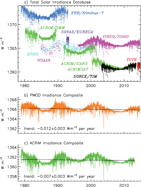
FIGURE 2.3.1 Spaceborne measurements of total solar irradiance (TSI) are shown on their “native” scales with offsets attributable to calibration errors. Instrument overlap allows the cross calibration of the offsets and the creation of composite TSI records This is possible because the TSI measuremenrs are sufficiently repeatable that true solar irradiance variations are detectable. Thus, individual TSI observations are all larger during times of higher solar activity (e.g., around 1990 and 2000). Also shown are two composite records of TSI, constructed using different assumptions about the calibration biases and drifts of individual measurements, and with different adopted absolute irradiance scales. Even with the cross-calibration achieved from instrument overlap, true multi-decadal solar change is arguably not yet detectable in the long-term TSI record because of insufficient long-term repeatability of most of the extant measurements. For this reason the two different composite records exhibit different long-term trends in addition to having different absolute scales; they are used to illustrate the value framework in Appendix B. To detect true TSI changes without instrument overlap requires absolute calibration with uncertainties an order of magnitude smaller than that of most of the observations shown in this figure. SOURCE: Adapted from Figure 1 of G. Kopp and J.L. Lean, 2011, A new, lower value of total solar irradiance: Evidence and climate significance, Geophysical Research Letters 38:L01706.
The quality of a geophysical data set also depends on its time and space sampling. For satellite observations, this sampling is determined by a combination of instrument design and satellite orbit. For suborbital observations (e.g., IceBridge) it is determined by instrument, airborne platforms, flight schedules, and flight tracks. Attempts to retrieve a long-term data set of a climate variable with an underlying cyclic or chaotic variation (e.g., diurnal or seasonal temperature variation, weather patterns) must take into account the time and space sampling of the satellite orbit.
Many geophysical variables (e.g., clouds and precipitation, sea level, biomass burning, tropospheric ozone) have significant temporal variation that may be both chaotic (weather systems) and systematic (diurnal or seasonal). For chaotic variability it is advantageous to have as many measurements as possible; but for systematic variability, it is critical to avoid a biased sampling of the diurnal or seasonal cycles typical with low Earth polar orbits (e.g., by flying dual instruments with one sun-synchronous and the other precessing). To achieve a measurement strategy for highly variable global systems such as clouds and precipitation, NASA ESD and its partnering national and international space programs include multiple sun-synchronous satellites in orbit at different times of the diurnal cycle, or sometimes single spacecraft that are in mid-inclination with orbits that precess through all local times of day. A high-temporal-repeat sampling strategy is also important for severe weather prediction, such as hurricanes, floods, lightning, and tornadoes, and is a primary focus of geosynchronous observing systems.
Time and space sampling is also relevant to intercalibration of overlapping sensors as discussed above in the section “Repeatability.” This may be illustrated by an analysis of the reduced uncertainty caused by changing the diurnal sampling time. EarthCare is an upcoming European Space Agency mission12 to make global observations of clouds, aerosols and radiation; its payload includes a high-resolution cloud and aerosol vertical profile lidar. CALIPSO,13 a spacecraft developed cooperatively by NASA and the Centre National d’Études Spaciales (CNES, the French space agency), makes observations from a 1330LT (1:30 pm, local time) ascending sun-synchronous orbit. However, EarthCARE is 1400LT, roughly 30 minutes later, which adds to uncertainty in climate trends of cloud properties because of the systematic time difference in regions with large cloud diurnal cycles. However, this type of uncertainty can be estimated from observations (geostationary satellites, surface lidar network, surface cloud observations) and used in determining the quality level for a changed orbit crossing time continuity observation. The effect of this change will vary with cloud type (marine boundary layer vs land convection) and spatial scale (regional, zonal, global). For aerosols, the diurnal cycle is much smaller but the same analysis will be required. In some cases, models can also be used to assess such an uncertainty depending on model fidelity for the diurnal cycle of interest.
Time and space sampling influences both the ability to resolve spatial and temporal features as well as the uncertainty with which they can be observed at a given time and space scale. Changing spatial resolution between instruments can lead to the need to spatially average new higher resolution observations to provide continuity with existing lower spatial resolution instruments. Time sampling shifts occur when: (1) there is a change in the local equator crossing time for a sun-synchronous satellite, either by design or through uncontrolled drift, (2) there is a change in satellite altitude, thereby altering the ground repeat cycle of images, or (3) there is a change in the longitude of a geostationary satellite or a change in the sampling rate of an on-board instrument. The derivation of long-term, multi-satellite atmospheric temperature trends from satellite microwave measurements is a prime example of where drifts in satellite altitude and local measurement times have significantly complicated the task. Corrections for local measurement time are one of the main sources of uncertainty in current climate-quality data sets from these microwave sounders (Box 2.4).
The meaning of gaps in time and space sampling can be confusing. All data sets have time and space gaps and/or smoothing. For measurements made by instruments on space-based platforms gaps are typically one of two types. The first, “Type 1,” is by design and is associated with orbit and instrument characteristics. For example, Landsat 8 orbits Earth once every 99 minutes at an average altitude of 438 miles (705 kilometers), repeating the
______________
12 For an overview of the EarthCare mission, see ESA (2011).
13 In 2006, NASA launched the CloudSat and the Cloud-Aerosol Lidar and Infrared Pathfinder Satellite Observation (CALIPSO) spacecraft to study the role that clouds and aerosols play in regulating Earth’s weather, climate, and air quality. See the CALIPSO mission homepage at http://www.nasa.gov/mission_pages/calipso/mission/.
same ground track every 16 days. “Type 2” gaps are unplanned gaps, usually related to instrument or spacecraft anomalies that either corrupt or eliminate an observation for a time period longer than Type 1 gaps.
This report does not define continuity of a measurement as a simple continuous time series of Type 1 gaps while avoiding all Type 2 gaps. Instead, measurement continuity pertains to maintaining the quality of the geophysical measurement, at the level needed to accomplish the quantified objective (see Section 3.1.1). This approach provides a robust, quantitative, and flexible definition for the quality of a measurement. Since quality relates to the combined standard uncertainty of the measurement, achieving the required quality can be accomplished with a wide range of potential combinations of instrument accuracy, repeatability, time/space sampling, algorithm and modeling uncertainty. Some instruments can be spaceborne while others can be surface or aircraft instruments. For example, a recent attempt to increase the quality of ice sheet elevation observation made by the short-lived ICESat satellite used aircraft lidar and radar observations in a program called IceBridge: these observations were designed to bridge the Type 2 gap between ICESat and ICESat 2 (Qi and Braun, 2013; Studinger et al., 2010).
BOX 2.4
Orbital Maintenance of Altitude and Time Sampling
Detection of climate change over a decade in atmospheric layers requires temperature to be measured to within an uncertainty of 0.2°C with a repeatability of 0.02°C (GCOS, 2010). This uncertainty and repeatability is needed to detect trends and variability in the troposphere and stratosphere temperature at global and regional scales, and to validate climate model predictions.
Atmospheric temperature has been measured from space since 1978 by microwave sounder instruments (Microwave Sounding Unit [MSU], Advanced Microwave Sounding Unit [AMSU], and Advanced Technology Microwave Sounder [ATMS]) carried on a series of National Oceanic and Atmospheric Administration, NASA, and EUMETSAT (European Organization for the Exploitation of Meteorological Satellites) satellites.1 Microwave sounders measure radiance emitted from the surface and atmosphere at specific frequencies. These radiance measurements are used, along with atmospheric weighting functions, to determine the mean temperature of thick layers of the atmosphere. Lower tropospheric temperature (TLT) retrievals are dependent on the difference between nadir and near-limb views and thus are especially sensitive to changes in Earth incidence angle. Drag caused by the upper atmosphere results in a slow decay in orbital altitude of a satellite throughout its mission, which changes Earth’s incidence angle and can produce a spurious decreasing trend in lower tropospheric temperature retrievals. Once the changes in Earth incidence angle are accounted for, the warming trend in these temperatures more closely matched surface measurements and modeled trends (Wentz and Schabel, 2000).
Additionally, diurnal variations in temperature may be aliased into the long-term temperature trend (Figure 2.4.1). There was an error in an early method developed to estimate and remove the effects of changing diurnal sampling (Christy et al., 2003). More recent methods use hourly output from general circulation models to simulate the diurnal cycle in radiance for each satellite view angle and channel, allowing the effects of diurnal sampling to be removed. (Mears and Wentz, 2005, 2009). These newer methods from the Remote Sensing System (RSS) still result in different trends (Figure 2.4.2) that compromise the quality of the temperature records; these records provide examples in Appendix B to illustrate the framework application.
______________
1 These measurements have been found to have many errors over time, highlighting the essential role of reprocessing in the generation of climate data records. See Bosilovich et al. (2011) and Abraham et al. (2014).
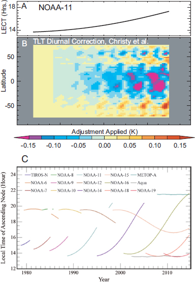
FIGURE 2.4.1 (A) Local equator crossing time for the NOAA-11 satellite plotted as a function of time. (B) Color-coded time-latitude plot of the diurnal corrections applied to lower tropospheric temperature (TLT). (C) Local time of ascending node for the NOAA (National Oceanic and Atmospheric Administration) series of satellites. SOURCE: (A and B) Adapted from C.A. Mears and F.J. Wentz, 2005, The effect of diurnal correction on satellite-derived lower tropospheric temperature, Science 309:1548-1551. Reprinted with permission from AAAS. (C) C.A. Mears, M.C. Schabel, and F.J. Wentz, 2003, A reanalysis of the MSU Channel 2 tropospheric temperature record, Journal of Climate 16:3650-3664. © American Meteorological Society. Used with permission.
Achieving the required measurement quality in the most cost-effective and risk-free manner may involve changing observation plans over time, especially as new technologies evolve. One such example is the CLARREO mission, whose objectives include serving as an in-orbit calibration reference and thereby greatly reducing space borne instrument calibration drift or shifts in calibration that occur across Type 2 gaps. The quality examples in Chapter 3 and the appendixes provide methods where uneven time and space sampling as well as varying levels of instrument or algorithm uncertainty are utilized in the determination of quality. This flexibility allows for an objective trade space that can accommodate the quality of changing space-borne observations, surface observations, aircraft or suborbital observations, model assimilation such as a weather re-analyses, and any combination of the these data sources. Examples of such analyses can be found for the impact of Type 2 data gaps for TSI (NRC, 2013), as well as for Earth radiation budget measurements (Loeb et al., 2009). Section 3.4.2 includes further discussion of the impact of unplanned gaps on measurement quality.
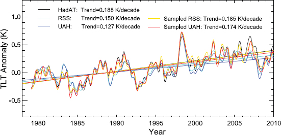
FIGURE 2.4.2 An example of the intercomparison of satellite data from Remote Sensing System, Inc. (RSS; red) and the University of Alabama, Huntsville (UAH; blue); and radiosonde-based data from the Hadley Centre (HadAT; black). For the satellite data, both the true globally averaged time series, and time series found by averaging together only those locations that have radiosonde data are shown. These data have been smoothed to remove variability on time scales shorter than 6 months. SOURCE: C.A. Mears, F.J. Wentz, P. Thorne, and D. Bernie, 2011, Assessing uncertainty in estimates of atmospheric temperature changes from MSU and AMSU using a Monte-Carlo estimation technique, Journal of Geophysical Research 116:D08112. Copyright 2011 by the American Geophysical Union.
2.2.4 Data Systems and Delivery for Climate Variables (Algorithms, Reprocessing, and Availability)
The development of climate data records requires the reprocessing14 of original instrumental raw observations to incorporate gains in knowledge of instrument calibration changes, instrument performance, improved or additional auxiliary data, and new or improved algorithms. For weather applications, the calibration of near real-time satellite measurements and the algorithms that produce geophysical quantities from the measurements, is sufficient for those needs, but must be reevaluated and refined in order to produce climate data records. It is advantageous to retrieve geophysical variables using consistent, state-of-the-art algorithms that evolve as knowledge of relevant processes increases, so that reprocessing of the longer time series is essential to achieve consistent climate data
______________
14 For more on reprocessing of climate data records and World Climate Research Programme guidelines for reprocessing, see WCRP (2012).
records. This requires periodic reprocessing of the entire data record using updated corollary data and a single “master” algorithm; it cannot be achieved by the single-pass processing used for operational weather purposes.
Thorough, independent validation of geophysical retrievals often can discern calibration or algorithm errors; conversely, instruments having a consistent calibration and algorithm approach to reprocessing typically provide the continuous data records of the highest quality. For satellite remote sensing observations, the accuracy of long-term, continuous geophysical data products also depends on retrieval algorithms and the effect on these algorithms of changes in instrument characteristics. Achieving continuity in geophysical and climate data products requires use of a consistent, state-of-the-art algorithm for producing the geophysical measurements (Box 2.5). The algorithm
BOX 2.5
Impact of Data Algorithms and Reprocessing on Cloud Optical Properties
Cloud optical thickness and effective radius from MODIS (Moderate-Resolution Imaging Spectroradiometer) have been processed many times to date, each time taking advantage of improved knowledge of instrument radiometric calibration and degradation, and improved knowledge gained from comparisons with ground-based, aircraft, and other space-based assets (e.g., CALIOP [Cloud-Aerosol Lidar with Orthogonal Polarization] on CALIPSO [Cloud-Aerosol Lidar and Infrared Pathfinder Satellite Observations]). The algorithms used to process these data are continually being improved, and thus reprocessing with state-of-the-art algorithms is essential to establish a high quality long-term data product. Furthermore, the MODIS cloud optical properties algorithm provides pixel-level uncertainty estimates, which are based on errors in the parameters in the processing algorithms, viz., instrument bias and noise, atmospheric correction errors (primarily water vapor), and surface reflectance uncertainty (including ocean reflectance uncertainty due to wind speed). Because of the sensitivity of the measured solar reflectance to these errors, the cloud algorithm estimates will depend on the solar and viewing geometry. Such quantitative error treatment, coupled with state-of-the-art algorithms, requires reprocessing and attention to error sources that is not possible with the one-pass analysis used for timely operational applications.
The National Oceanic and Atmospheric Administration (NOAA) presently operates VIIRS (Visible Infrared Imaging Radiometer Suite), the follow-on to MODIS, in operational weather product processing mode, but has been given only limited funding for VIIRS climate data record processing. The operational weather processing mode does not permit multiple reprocessing and algorithm updates, level-3 gridded and time-averaged global products, or processing time delays to allow updated ancillary information necessary to produce high-quality climate data record. All of these issues must be addressed if the current VIIRS measurements are to be used to continue the MODIS-established climate data records.
Figure 2.5.1 shows ice cloud mean optical thickness for September 2012 derived from three different analyses, one using MODIS observations and two others using VIIRS. The top two panels display results based on nearly identical algorithms applied to two different data sets: MODIS and VIIRS. (The differences are that the MODIS collection 6 cloud product from the Aqua spacecraft uses the MODIS cloud mask and cloud top pressure retrievals while the MODIS-like algorithm applied to the VIIRS data set obtains cloud mask, thermodynamic phase, and cloud top pressure information from a different source due to lack of certain bands being available on VIIRS.)
The bottom two panels display results from two different algorithms applied to the same VIIRS data set. The agreement between the two similar algorithms, but different input files, is quite good, especially in comparison to the operational weather product (bottom panel) where there is an overall negative bias in ice cloud optical thickness due to a different algorithm. This is an example of the need for constant attention to algorithm improvement, periodic reprocessing, and careful error characterization necessary to produce climate-quality Earth science observations. VIIRS is potentially capable of continuing the high-quality Earth science observations begun (in many cases) with MODIS, providing that the algorithms are refined to account for subtle (and sometimes significant) changes in information content of select spectral bands.
must yield well-characterized products and their uncertainties, and the uncertainty in the measurement must be commensurate with the natural variation in the quantity being measured. The need for reprocessing also requires that the original raw measurement stream from the instrument remain available, and that computing power to fully reprocess the record also be available.
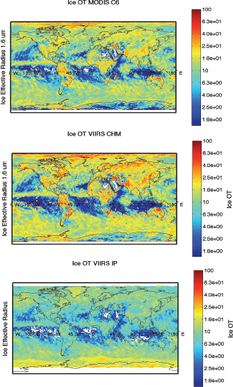
FIGURE 2.5.1 Global September 2012 aggregation of mean ice cloud optical thickness from the Collection 6 MODIS algorithm from Aqua (top), MODIS-like algorithm applied to VIIRS (middle), and operational weather (IDPS) product derived from VIIRS (bottom). NOTE: IDPS, Interface Data Processing Segment; MODIS, Moderate-Resolution Imaging Spectroradiometer; VIIRS, Visible Infrared Imaging Radiometer Suite. SOURCE: S. Platnick, S.A. Ackerman, B.A. Baum, A.K. Heidinger, R.E. Holz, M.D. King, W.P. Menzel, S. Nasiri, E. Weisz, and P. Yang, 2013, Assessment of IDPS VIIRS Cloud Products and Recommendations for EOS-era Cloud Climate Data Record Continuity, Report to NASA Headquarters, Washington, D.C.
Abraham, P., J. Cook, J.T. Fasullo, P.H. Jacobs, S.A. Mandia, and D.A Nuccitelli. 2014. Review of the consensus and asymmetric quality of research on human-induced climate change. Cosmopolis 1:3-18.
Bindoff, N.L., P.A. Stott, K.M. AchutaRao, M.R. Allen, N. Gillett, D. Gutzler, K. Hansingo, et al. 2013. Detection and Attribution of Climate Change: From Global to Regional. Chapter 10 in Climate Change 2013: The Physical Science Basis. Contribution of Working Group I to the Fifth Assessment Report of the Intergovernmental Panel on Climate Change (Stocker, T.F., D. Qin, G.-K. Plattner, M. Tignor, S.K. Allen, J. Boschung, A. Nauels, Y. Xia, V. Bex, and P.M. Midgley, eds.). Cambridge University Press, Cambridge, U.K., and New York, N.Y.
Bosilovich, M.G., J. Kennedy, D. Dee, and A. O’Neill. 2011. “On the Reprocessing and Reanalysis of Observations for Climate.” WCRP Position Paper. Version 1.1. October 17. http://www.wcrp-climate.org/conference2011/documents/B4ReprocessingReanalysis.pdf.
Bosilovich, M.G., J. Kennedy, D. Dee, R. Allan, and A. O’Neill. 2013. On the reprocessing and reanalysis of observations for climate. Pp. 51-71 in Climate Science for Serving Society: Research, Modeling and Prediction Priorities (G.R. Asrar and J.W. Hurrell, eds.). Springer Science+Business Media Dordrecht. doi:10.1007/978-94-007-6692-1_3.
Christy, J.R., R.W. Spencer, W.B. Norris, W.D. Braswell, and D.E. Parker. 2003. Error estimates of version 5.0 of MSU-AMSU bulk atmospheric temperatures. Journal of Atmospheric and Oceanic Technology 20:613-629.
CIESIN (Earth Institute of the Center for International Earth Science Information Network). 2013. State of the Planet: Blogs: “A Road Map Toward Better Understanding of Global Environmental Change.” http://blogs.ei.columbia.edu/2013/03/04/a-road-map-towards-better-understanding-of-global-environmental-change/.
Dowell, M., P. Lecomte, R. Husband, J. Schulz, T. Mohr, Y. Tahara, R. Eckman, et al. 2013. Strategy Towards an Architecture for Climate Monitoring from Space. Available from http://www.ceos.org, http://www.wmo.int/sat, and http://www.cgmsinfo.org/.
ESA (European Space Agency). Earthcare Earth Explorers. 2011. Earthcare Mission Overview. http://www.esa.int/Our_Activities/Observing_the_Earth/The_Living_Planet_Programme/Earth_Explorers/EarthCARE/Overview2.
Flato, G., J. Marotzke, B. Abiodun, P. Braconnot, S.C. Chou, W. Collins, P. Cox, et al. 2013. Evaluation of Climate Models. Chapter 9 in Climate Change 2013: The Physical Science Basis. Contribution of Working Group I to the Fifth Assessment Report of the Intergovernmental Panel on Climate Change (Stocker, T.F., D. Qin, G.-K. Plattner, M. Tignor, S.K. Allen, J. Boschung, A. Nauels, Y. Xia, V. Bex, and P.M. Midgley, eds.). Cambridge University Press, Cambridge, U.K., and New York, N.Y.
GCOS (Global Climate Observing System). 2010. Guideline for the Generation of Datasets and Products Meeting GCOS Requirements. GCOS-143. May. http://www.wmo.int/pages/prog/gcos/index.php?name=Publications.
Goldberg, M., G. Ohring, J. Butler, C. Cao, R. Datla, D. Doelling, V. Gärtner, et al. 2011. The global space-based inter-calibration system. Bulletin of the American Meteorological Society 92:467-475.
Kopp, G., and J.L. Lean. 2011. A new, lower value of total solar irradiance: Evidence and climate significance. Geophysical Research Letters 38:L01706.
Leroy, S.S., J.G. Anderson, and G. Ohring. 2008. Climate signal detection times and constraints on climate benchmark accuracy requirements. Journal of Climate 21:841-846.
Loeb, N.G., B.A. Wielicki, W. Su, K. Loukachine, W. Sun, T. Wong, K.J. Priestley, G. Matthews, W.F. Miller, and R. Davies. 2007. Multi-instrument comparison of top-of-atmosphere reflected solar radiation. Journal of Climate 20:575-591.
Loeb, N.G., B.A. Wielicki, T. Wong, and P.A. Parker. 2009. Impact of data gaps on satellite broadband radiation records. Journal of Geophysical Research 114:D11109.
Mears, C.A., and F.J. Wentz. 2005. The effect of diurnal correction on satellite-derived tropospheric temperature. Science 309:1548-1551.
Mears, C.A., and F.J. Wentz. 2009. Construction of the RSS V3.2 lower tropospheric dataset from the MSU and AMSU microwave sounders. Journal of Atmospheric and Oceanic Technology 26:1493-1509.
Mears, C.A., M.C. Schabel, and F.J. Wentz. 2003. A reanalysis of the MSU Channel 2 tropospheric temperature record. Journal of Climate 116:3650-3664.
Mears, C.A., F.J. Wentz, P. Thorne, and D. Bernie. 2011. Assessing uncertainty in estimates of atmospheric temperature changes from MSU and AMSU using a Monte-Carlo estimation technique. Journal of Geophysical Research 116:D08112.
Myhre, G., D. Shindell, F.-M. Bréon, W. Collins, J. Fuglestvedt, and J. Huang. 2013. Anthropogenic and Natural Radiative Forcing. Chapter 8 in Climate Change 2013: The Physical Science Basis. Contribution of Working Group I to the Fifth Assessment Report of the Intergovernmental Panel on Climate Change (Stocker, T.F., D. Qin, G.-K. Plattner, M. Tignor, S.K. Allen, J. Boschung, A. Nauels, Y. Xia, V. Bex, and P.M. Midgley, eds.). Cambridge University Press, Cambridge, U.K., and New York, N.Y.
NAC (NASA Advisory Council). 1986. Earth System Science: Overview: A Program for Global Change. Report of the Earth System Sciences Committee. NASA, Washington, D.C.
NASA. 2008. Perspectives on EOS, Special Edition. March-April. The Earth Observer 20(2). http://eospso.nasa.gov/sites/default/files/eo_pdfs/Perspectives_EOS.pdf.
NASA. 2010. Responding to the Challenge of Climate and Environmental Change: NASA’s Plan for a Climate-Centric Architecture for Earth Observations and Applications from Space. http://science.nasa.gov/media/medialibrary/2010/07/01/Climate_Architecture_Final.pdf.
NASA. 2014. 2014 Science Plan. http://science.nasa.gov/media/medialibrary/2014/05/02/2014_Science_Plan-0501_tagged.pdf.
NASA. 2015. “Earth System Science Pathfinder.” http://science.nasa.gov/about-us/smd-programs/earth-system-science-pathfinder/. Accessed April 6, 2015.
NRC (National Research Council). 2007. Earth Science and Applications from Space: National Imperatives for the Next Decade and Beyond. The National Academies Press, Washington, D.C.
NRC. 2013. Review of NOAA Working Group Report on Maintaining the Continuation of Long-Term Satellite Total Irradiance Observations. The National Academies Press, Washington, D.C.
Platnick, S., S.A. Ackerman, B.A. Baum, A.K. Heidinger, R.E. Holz, M.D. King, W.P. Menzel, S. Nasiri, E. Weisz, and P. Yang. 2013. Assessment of IDPS VIIRS Cloud Products and Recommendations for EOS-era Cloud Climate Data Record Continuity. Report to NASA Headquarters, Washington, D.C.
Qi, W., and A. Braun. 2013. Accelerated elevation change of Greenland’s Jakobshavn glacier observed by ICESat and ICEBridge. IEEE Geoscience and Remote Sensing Letters 10(5):1133-1137.
Studinger, M., L. Koning, S. Martin, J. Sonntag, and IEEE. 2010. Operation IceBridge: Using instrumented aircraft to bridge the observational gap between ICESat and ICESat-2. Geoscience and Remote Sensing Symposium (IGARSS), 2010 IEEE International.
Wentz, F.J., and M. Schabel. 2000. Precise climate monitoring using complementary satellite data sets. Nature 403:414-416.
Wielicki, B.A., D. F. Young, M.G. Mlynczak, K.J. Thome, S. Leroy, J. Corliss, J.G. Anderson, C.O. Ao, R. Bantges, F. Best, K. Bowman, et al. 2013. Climate Absolute Radiance and Refractivity Observatory (CLARREO): Achieving climate change absolute accuracy in orbit. Bulletin of the American Meteorological Society 94:1519-1539.
WCRP (World Climate Research Programme). 2012. “The WCRP Observation and Assimilation Panel (WOAP).” http://www.wcrp-climate.org/WOAP_documents.shtml.


