
2
Recent Transformative Innovations in the Geographical Sciences
In this chapter, the committee examines selected case studies of major transformative research events in the geographical sciences that occurred during the late 20th and early 21st centuries. These events are considered in the context of general models of the diffusion of innovation and the potential general lessons they might provide on research innovators and successful diffusion.
TRANSFORMATIVE RESEARCH AND GENERAL MODELS OF THE DIFFUSION OF INNOVATION
Many geographical scientists are aware of the treatises by philosophers such as Paul Feyerabend, Thomas Kuhn, Imre Lakatos, and Karl Popper on the underlying nature of science and scientific revolutions. There is a long history of examining the geographical sciences in relation to such philosophical perspectives and debates (e.g., Bassett, 1999; Bird, 1977; Johnston, 1997; Mair, 1986; Wheeler, 1982). Most recently, Inkpen and Wilson (2013) provide an examination of physical geography in this context. These philosophical views range from the progression of science conceptualized as a logical and formal process of the construction, testing, and refutation of hypotheses, as espoused by Popper, to the much messier and perhaps more realistic view of Kuhn and Lakatos that progress occurs by the overthrow of entrenched paradigms and programs and the triumph of competing paradigms. Finally, there is the rejection of any real rationality in scientific creativity and progress as argued by Feyerabend.
An alternative way to consider the patterns and processes by which transformations in scientific fields occur is through the lens of the Diffusion of Innovation Theory. Rogers (1962) conducted seminal work in this field, which has been further developed over the past 50 years (e.g., Eveland, 1986; Godin, 2006; Hall, 2004; Peres, 2010; Rogers, 2003; Rosenberg, 1972; Wejnert, 2002; Wisdom et al., 2014). Research on the Diffusion of Innovation Theory has largely been conducted in the context of product development and marketing. Models of innovation diffusion are also widely applied to economic sectors, such as technology and biomedicine, and in realms such as public policy and education. Both economists and the business sector are particularly interested in how innovative, new products are optimally developed, refined, and then diffused to acquire maximum market share. The initial creation, further development, diffusion, and adoption of transformative research may be examined in the same manner.
Rogers graphically summarized the innovation-diffusion process as the logistic growth in market share as a product is developed and then diffused. Underlying this notion is a normal distribution of innovators, early and late adopters, and then the final adopters (so called “laggards”) (Rogers, 2003). In the context of transformative research, this process can be seen as the method through which an idea is created by one person or a small number of individuals, followed by a small number of early adopters who actively refine and develop it, after which the idea diffuses to other researchers. Finally, the idea gains credence and is applied by the majority of researchers in the field. The remaining “laggards” adopt the transformative research paradigm late in the game, for want of information, lack of capacity to implement, or due to initial intellectual resistance. In the arena of academic research, an important part of this process would be the communication of both the existence of a new research paradigm and knowledge about how to successfully apply it oneself. No matter how appealing an idea or technology might be, if it cannot be applied by potential adopters due to complexity or capital costs, it is unlikely to be transformative. In the case of “pure” research, the equivalent of market share for a transformative idea might be the number of peer-reviewed publications, citations, and doctoral students, among others.
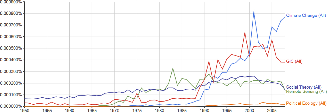
Is there any empirical evidence that the adoption of transformative research follows a pattern similar to that proposed by Rogers? Data for a number of recent transformative research areas in the geographical sciences suggest some truth in the general model. Examples drawn from an n-gram analysis of published books in the Google database (Lin et al., 2012) all show a logistic pattern of growth in the use of terms related to transformative research paradigms in the geographical sciences (see Figure 2.1). Fields such as remote sensing of the environment matured and reached a steady state early, while areas such as global climate change are still increasing. Indeed, Rogers’s model of innovation diffusion is identical in form to the Isserman Curve of productive scientific inquiry that the National Science Foundation’s (NSF’s) Geography and Spatial Sciences (GSS) program has used in panel assessments (NSF, 2011). In that formulation, the curve represents the accumulated knowledge generated by the incipient creation of research ideas through to the end phase of gap filling when further major innovation and generation of significant new knowledge is unlikely (Baerwald, 2013).
What then, in general terms, drives the initial development, refinement, and diffusion of an innovation? In the context of marketing, the impetus for innovation and diffusion has been characterized in terms of (1) “technology push,” where inventors and innovators recognize that a newly created and developing technology or idea has the potential for widespread adoption (i.e., market share) in some sectors; or (2) “market pull,” where the eventual adopters of a technology or other product provide explicit demand and support for the development of new innovations to meet pressing needs (Dowling, 2004). For example, in environmental technology development, the market pull created by newly implemented governmental regulations may provide the most important impetus to develop new products (Horbach et al., 2012). In the section that follows, these concepts are developed in terms of four specific findings and their supporting discussions.
Committee Findings
Experience shows that a transformative innovation may be a singular event attributable to one individual or a single networked group, or it may arise independently among distinct individuals or groups. What lies at the heart of an original and revolutionary innovation and how to predict and then promote such breakthroughs has long been a focus of considerable thought and debate. To date, no general model is widely accepted (Simonton, 2009; Sulloway, 2009). Transformative innovations can range from the relatively sudden appearance of revolutionary new ideas, such as the initial publications of Charles Darwin’s Theory of Natural Selection or Louis Agassiz’s glacial theories, to long-term incremental advances in tools, such as the progression from balloon photography to satellite remote sensing. Transformative ideas may also be built on earlier concepts that are evolutionarily refined and grow in application, are reframed in new and sometimes controversial ways, or are based on retrogressive approaches that resurrect previously discarded ideas (Sulloway, 2009). As a negative example of the latter, obsolete Lamarckian evolutionary theory was forced on Soviet science by Tofim Lysenko in the 1930s; while as a positive example, one might cite the resurrection and validation of Alfred Wegener’s Continental Drift Theory following World War II.
Finding 1: Transformative innovations can arise from a wide variety of individuals and groups, from a wide variety of intellectual sources, including older and long-ignored ideas, and through revolutionary or evolutionary paths.
A question that confronts firms in the development of innovative new products is whether to embrace open or closed models of innovation (Chesbrough, 2003). Is the faith in one’s individual capacity to secretly develop a product and accrue the potential competitive advantages of that product outweighed by the synergies and infusion of new ideas and technologies into product development, which would accrue in an open setting with many groups and individuals within and outside the firm freely exchanging information? It has been argued that in the technology sector an open innovation approach is the most successful, despite the potential loss of product exclusivity (Chesbrough, 2003). Two recent examples of commercial firms embracing this approach are the release of patented battery technology by Tesla Motors and the release of patented fuel cell technology by Toyota Motor Corporation.
Finding 2: An open innovation system in academic science and research can encourage the exchange of information, even among competing groups, and helps to achieve the desire of the nation, funding agency, or foundation for the most rapid, productive, and efficient academic research sector.
No matter how brilliant a new research concept may be, it will not be transformative unless it is widely adopted. This widespread adoption entails refinement and diffusion. In its simplest formulation, the inception and progress of a scientific transformation might be seen as the classical three-phase process of invention, innovation, and diffusion (Bush, 1945; Godin, 2006). However, it is now widely recognized that this linear model is an oversimplification of the dynamics that occur in the development and adoption of innovation. Rather, successful development and diffusion of innovation typically happen through a process of backward and forward communication and resulting feedback among the inventors, innovators, and adopters (Bogers et al., 2010; Godin, 2006; Tuomi, 2002; von Hippel, 1986).
Finding 3: The promotion of rapid communication among innovators and adopters is critical for development as well as for the diffusion of transformative innovations.
Where might the biggest payoff and least risk be when attempting to identify and promote the innovation and diffusion of a promising transformative research idea? It is typically difficult to identify a successful innovation in its earliest stages of development. Consider this in light of the success rate for the commercialization of U.S. patents and of venture-capital investments. Of the roughly 1.5 million current patents issued, only about 3,000 (0.2 percent) are eventually commercially viable (Klein, 2005). Venture-capital investments typically have high failure rates (i.e., greater than 50 percent) even after careful analysis of startups by investment firms (Sahlman, 2010). Furthermore, only about 1 percent of venture capital is actually invested in embryonic seed-stage companies, while 45 percent and 50 percent is invested in relatively mature early-stage companies and in developed later-stage companies, respectively, that offer greatly reduced risk as compensation for reduced rates of investment return (Korteweg and Sorensen, 2010).
Finding 4: There are no established indicators that would identify specific individuals or concepts as sources of transformative innovation prior to the conduct of research.
Using innovation diffusion theory and commercial experiences as admittedly imperfect general guides, one might modify Rogers’s heuristic model to incorporate some indication of risk and potential reward to the institution seeking to develop and diffuse innovative and transformative scientific research technologies and paradigms. In this conceptualization, resources specifically targeted to promote innovation are spread among inventors and early innovators to promote the development of risky but potentially innovative new ideas. Similarly, some of these innovation-targeted resources are provided to allow for full diffusion and widespread application of mature innovations to later-stage majority users. The bulk of the innovation resources, however, are focused on the period of late innovation and early adoption when proof of concept is clear and applicability is demonstrated. This is the time when resources for final optimal development and early diffusion of the innovation can provide maximum leverage through mutually beneficial feedback between early adopters and innovators, producing rapid refinement of the idea.
Aside from resources for direct technical development or application, communication between and among innovators and adopters is also an important area for support. Again, at this stage, support can have high impact because such communication can promote refinement of the idea through feedback between innovators and adopters, and can also accelerate dissemination. Of note, this model refers only to the proportion of total resources specifically targeted to promote innovation, and this investment occurs in the context of sufficient additional resources being allocated to both developed and ongoing areas of research.
CASE STUDIES: INVENTION AND EARLY INNOVATION
In this section, the committee examines five areas of research that have been transformative in the geographical sciences within the past 65 years. These areas are discussed under the five broad rubrics of political ecology, spatial social theory (i.e., social theory that is directly informed by and related to geography), remote sensing of the environment, geographic information systems (GISs) and sciences, and global climate change. This list of research areas is not comprehensive, omitting significant areas of the geographical sciences where transformations have undoubtedly occurred. Nevertheless, it represents a manageable sample of significant transformations that provides useful input to the committee’s further deliberations and recommendations. Each of the research areas is now maturely developed, represented in geographical sciences departments and beyond, and widely published. One would not have encountered any of these rubrics within the geographical sciences prior to the mid-20th century and they thus clearly represent significant transformations.
During this period, there have been contemporary transformative events within long-recognized fields of the geographical sciences, such as the theory of island biogeography within the field of biogeography (MacArthur and Wilson, 1967) and non-equilibrium theories in the field of geomorphology (Phillips, 1992). Similarly, within the broader field of geography, there have been transformative developments such as the quantitative revolution (Burton, 1963) and the critical social theory of space and place (Harvey, 1973; Massey, 1973). Newer concepts, such as sustainability science (Kates et al., 2001) and integrated approaches to the Anthropocene period (Crutzen, 2006), are currently diffusing rapidly within the geographical sciences and will likely have similarly significant impacts. These and other past and present transformative events are all worthy of examination, but lie beyond the scope of this report. The five case studies presented here identify many of the inventors and early innovators, sources of ideas, and stimuli responsible for the development and widespread diffusion of these transformative research areas within and beyond the geographical sciences. These histories will then be considered in the context of the general innovation-diffusion concepts discussed above. The accounts, which by the nature of this report must be the briefest of outlines, are drawn in part from literature, but also rely on the expert views and opinions expressed by the workshop participants.
The individuals or groups who are responsible for the invention and early-stage innovation of the five transformative research areas discussed here come from both within and outside the academic discipline of the geographical sciences, and indeed in some cases from outside the traditional academic-research sphere altogether. It is recognized and argued here that attribution of important and transformative research ideas to any individual or one seminal piece of work is often impossible; and it is equally impossible to identify all individuals responsible. Hence, the intent here is to illustrate by example rather than to be exhaustive.
Political Ecology
Political ecology is a melding of agricultural and soil sciences with development studies and political economics. The geographical sciences in the area of political ecology were transformed by the shift in focus from the classical agricultural/environmental and cultural views of rural development to the examination of larger economic forces, mainly from a perspective of political economy theory. The early transformative ideas are associated with both anthropology and geography (Blaikie, 2008; Bryant, 1998; Escobar, 1999; Robbins, 2012). Many consider Blaikie and Brookfield’s widely cited 1987 book Land Degradation and Society as pivotal in defining this area of research. However, the term political ecology has been used in additional and earlier contexts. For example, in 1935, a note by botanist/journalist Frank Thone compared Japanese displacement of indigenous pastoralists in Manchuria to the 19th-century displacement of Native Americans by U.S. expansion (Thone, 1935). Eric Wolf
used the term in connection with a symposium published in Anthropological Quarterly, which according to Wolf, demonstrated “how sophisticated anthropologists have become in following through the connective linkages in local ecosystems and in specifying the parameters of economic change” (Wolf, 1972, p. 201). Additional antecedents can be found in part in traditional rural regional development, hazards, and cultural ecology studies, and in part in radical geography informed by Marxism and political-economy perspectives (Bryant, 1998; Robbins, 2012). The most direct lineage is to work on the political economy of the environment and hazards (e.g., Hewitt, 1983; O’Keefe et al., 1976; Watts, 1983).
Political ecology has retained the attention of anthropologists. Some anthropologists, however, have acknowledged that by the 1990s “geographers and ecological economists [had] taken the lead in this endeavor” (Escobar, 1999, p. 2). In the 1980s and 1990s, political ecology became dominated by geographers studying development with students, especially from Clark University and the University of California, Berkeley, adopting it as their research approach and later becoming leaders in the field both within geography and more broadly (e.g., Peet and Watts, 1996). All of this activity helped to further develop political ecology and led to the growth of this research field within the geographical sciences, which, in turn, led to the ascendency of the discipline within this field.
Notably, political ecology provided particularly powerful analyses of the impacts of neoliberalism and the commodification of nature on livelihoods and landscapes in regions such as the Amazon, the Andes, Mexico, and sub-Saharan Africa, focusing on environmental resources that included water, forests, biodiversity, wetlands, carbon, and fisheries (Carney, 1993; Hecht and Cockburn, 1989; Liverman, 1990a; Zimmerer, 1991). In contemporary geography, political ecology is a common approach to human–environment relations and includes many studies in the developed as well as developing worlds (Peet et al., 2011; Robbins, 2012). The work of political ecologists now informs both environmental policy and environmental activism (Perrault et al., 2015).
If one were to look for seminal figures in the development of political ecology in the geographical sciences, one might cite Blaikie and Watts. Both came out of a doctoral background concerned with agricultural development in India and in Africa, respectively. There is a clear trajectory between their early career work and their development of political ecology. To Blaikie and co-author Brookfield might go the credit for defining political ecology as it is considered in the geographical sciences: “The phrase political ecology combines the concerns of ecology and a broadly defined political economy. Together, this encompasses the constantly shifting dialectic between society and land-based resources, and also within classes and groups within society itself” (Blaikie and Brookfield, 1987, p. 17).
Spatial Social Theory
Spatial social theory is another transformative research area for which disciplines such as sociology acknowledge a strong debt to the geographical sciences. It has a similar genesis to political ecology in that some of the earliest work in its conceptualization can be traced to sources outside the geographical sciences. In this case, the German sociologist/philosopher Georg Simmel’s work Die Grosstädte und das Geistesleben (The Metropolis and Mental Life; Simmel, 1903) might be considered an early fountainhead. Subsequent development of critical social theory within the context of the geographical sciences was highly influenced by the work of the French philosophers Henri Lefebvre, most notably perhaps La production de l’espace (1974), and Michel Foucault (e.g., Foucault, 1976). At approximately the same time within the geographical sciences, David Harvey in his book Social Justice in the City (Harvey, 1973) was laying the groundwork for critical spatial social theory that would be an essential component in its early-stage innovation. Other geographical scientists, such as Doreen Massey (1973, 1994), followed similar lines of analysis with vigor and insight. Related critical reframings of urban social theory were also being pursued well beyond the geographical sciences at this time (e.g., Gordon, 1978), helping to ferment a rich
intellectual medium. As is the case with political ecology, the list of scholars whose work formed the initial impetus included both geographical scientists and representatives of other fields, although all were Marxist in their analytic perspectives and linked theories of political economy with the development and delineation of urban space.
Interestingly, Harvey’s doctoral work was in historical geography, which was followed by his influential 1969 book Explanation in Geography (Harvey, 1969) that propounded a largely positivist and quantitative perspective for the geographical sciences. Although historical analysis remains important in the work of Harvey, his trajectory as an innovator of the more radicalized and activist perspectives he developed was not clearly presaged in his earliest work. Concurrently, sociologist Harvey Molotch’s 1976 paper “The City as a Growth Machine” (Molotch, 1976) further drove urban spatial theorists to move beyond former views of the role of geography in the city and consider the social context of land parcels and the opportunistic and contextual social factors of the different communities that help determine urban form. Free access to U.S. Census Bureau data on the geographical distribution of variables such as income and race provided critical empirical data to formulate and test hypotheses. Such data, for example, played an important role in Molotch’s paper. As the innovation of spatial social theory progressed, geographical scientists such as Kay Anderson, Peter Jackson, Linda McDowell, and others expanded beyond the political economy context of class to include issues of spatial structure in the context of social constructions of race (Anderson, 1987; Jackson, 1987) and gender (Massey, 1994; McDowell, 1993).
Remote Sensing of the Environment
Remote sensing of the environment transformed the geographical sciences through the capacity to examine Earth-surface features and processes from air- and space-borne platforms. Although often coarse in spatial resolution, this allowed integrated analysis spanning vast geographical areas and remote locations quickly and with increasingly sophisticated measurements of surface properties. Over the past 50 years, satellite remote sensing of the environment has come to form a major component of research in the geographical sciences. Modern remote sensing of the environment has its antecedents in the 1840s to 1860s, when François Arago, director of the Paris Observatory, proposed the concept of using photographs taken from balloons for the purpose of topographical surveys (Aronoff, 2005). Airborne photography for civilian and military use further expanded with the invention of the airplane.
Both the technology of image acquisition and the methods of photogrammetry and interpretation were accelerated by military applications during World War II. Immediately after the close of the war, captured German V-2 rockets were used by the now antagonistic American and Soviet military to take photographs of the Earth from the thermosphere—and the science of space-borne remote sensing was born. However, as the military took the lead in technology development and deployment, access to the latest developments was generally kept from civilian users (Aronoff, 2005). The declassification of remote-sensing technologies and images during the late 1950s through the 1970s allowed for the flowering of space-borne remote sensing of the environment as an academic research area (Aronoff, 2005). Indeed, the term remote sensing of the environment first appears during the period of the early 1960s, perhaps most notably with the convening of the first International Symposium on Remote Sensing of Environment in 1962. This conference was held at the Willow Run Laboratories at the University of Michigan, which was largely an engineering and defense research facility. Although some geographical scientists were undoubtedly involved in the earlier development of space-borne remote-sensing techniques, this line of research, its potential applicability, and the term remote sensing of the environment explicitly entered the geographical sciences literature in the early 1960s (Bailey, 1963; Bird and Morrison, 1964).
It is the launch of ERTS 1/Landsat 1 in 1972 that serves as a point in time when the modern and transformative science of remote sensing of the environment can be said to have commenced. Originally called the Earth
Resources Technology Satellite (ERTS 1) and later renamed Landsat 1, this was the first platform designed specifically for the collection of data on Earth-surface conditions and natural resources. Geologist William T. Pecora, director of the U.S. Geological Survey (USGS) from 1965 to 1971, is considered largely responsible for the higher-level vision and political effort that led to the creation of the ERTS/Landsat series of Earth-observing satellites (USGS, 2012). The satellite was built by General Electric, designed and launched by the National Aeronautics and Space Administration (NASA) in partnership with the U.S. Department of the Interior, and funded by the U.S. government (USGS, 2012; Williams, 1974). This event was at the vanguard of the explosive growth in environmental remote sensing through the 1970s and 1980s (see Figure 2.1). Over the past 40 years, it has been joined by a host of environmental remote-sensing satellites, which have been governmental and private in ownership and from a variety of countries. An early publication regarding ERTS 1, its potential, and some of its earliest results was issued by USGS in 1976 (Williams, 1976). Although dominated by scientists from the federal government, it is notable that academic geographical scientists—including Neal G. Lineback from the University of Alabama, Richard Ellefsen from California State University, San Jose, and John B. Rehder from the University of Tennessee—were among the small group of nongovernmental scientists working on the earliest development of ERTS 1 applications and products (Williams, 1976). By the 1970s, environmental remote sensing was transforming research and educational curricula in many geographical sciences departments (Estes and Thaman, 1974).
Important early roles in the development of environmental remote sensing were played by geographers David Simonett and Jack Estes. Simonett held a doctorate in geography and was a pioneer in radar remote sensing. Working with colleagues from engineering and geology departments, Simonett co-established a radar-based remote sensing unit at the University of Kansas in 1966. He later worked in the commercial sphere at Earth Satellite Corporation and eventually joined Estes on the faculty of geography at the University of California, Santa Barbara (Morain, 2006). After obtaining a geography degree, Estes worked in remote-sensing intelligence with the Central Intelligence Agency and then with Texas Instruments before returning to university for a geography doctorate in cartography. He was a pioneer in developing marine remote sensing of phenomena such as oil spills. With Simonett, he established a remote-sensing unit in the Department of Geography of the University of California, Santa Barbara, in 1972. Estes also wrote a widely used textbook and later undertook extended assignments in federal agencies, including USGS and NASA, to help formulate national remote-sensing strategies (Dozier and Asrar, 2001; Jensen, 2008).
Unlike political ecology, the inception of environmental remote sensing cannot be said to have been instigated by a small group of seminal figures, but rather has been “big science” and “big technology” from the start, with a host of innovators working to create the broad spectrum of innovations that collectively gave rise to this research area.
Geographic Information Systems and Science
Although cartography and the analysis of maps has always been at the heart of the geographical sciences, the development and deployment of computerized GISs has not only revolutionized the collation, mapping, and visual presentation of geospatial data in a rapid and efficient manner, but allowed for the detailed quantitative spatial analysis of individual variables and the synthetic and integrative analysis of multiple variables simultaneously. In the past two decades, research and teaching in GIS have become a fixture of any geographical sciences program of note. In addition to having considerable synergy with remote sensing, its inception may in some ways be seen as a hybrid of how political economy was conceived and how environmental remote sensing developed. The history of GIS in the mid to late 20th century has several elements (Chrisman, 2006; Coppock and Rhind, 1991; Esri, 2012; Tomlinson and Toomey, 1999), but if one figure were to be cited as seminal in the inception of GIS it would
be Roger Tomlinson of Canada. He held undergraduate and graduate degrees in geography from both the United Kingdom and Canada. The focus of his master’s degree work at McGill University was on glacial geomorphology (Tomlinson, 1963). Tomlinson worked in the private sector on aerial photography (Tomlinson and Brown, 1962) and then as a consultant to, and subsequently employee of, the government of Canada. There, he conceived the first computerized GIS and developed it in collaboration with International Business Machines (IBM). The introduction of the actual term geographic information system can be found in his 1968 publication A Geographic Information System for Regional Planning and its origins in his work can be traced to earlier reports and publications (Department of Forestry and Rural Development, 1967; Tomlinson, 1962).
Tomlinson’s vision, which became the Canada Geographic Information System (CGIS), was initially devised to solve a technical problem in the government of Canada, that of accurately estimating areas of land from the maps being drawn for the Canada Land Inventory. Known techniques were labor intensive and inaccurate; Tomlinson speculated that if the problems of digitizing maps and storing their contents in computers could be solved, then computing and reporting areas would be both fast and accurate. Computers had been developed as calculating machines. At the time, the idea of using them to manipulate the contents of maps was outlandish, and the technology to scan maps had to be invented from scratch. Perhaps the most innovative aspect of CGIS was the notion of using computers to analyze the contents of maps. It was this last idea that led to the initial adoption of GIS as a useful and eventually transformative tool for the geographical sciences.
The conception of GIS owes much to Tomlinson, but at least three other sources can be recognized. One is Howard Fisher, an architect, who founded the Laboratory for Computer Graphics at Harvard University in the 1960s to develop computer software for mapping. The second is Jack Dangermond, a landscape architect, who in 1969 founded the commercial company Environmental Systems Research Institute (Esri) following his studies and work in the Graduate School of Design and the Laboratory for Computer Graphics at Harvard University. (Esri now dominates the market for commercial, governmental, and academic GIS with its ArcGIS line of software products.) A third is the group at the U.S. Census Bureau that developed geographic databases, such as the Geographic Base File/Dual Independent Map Encoding (GBF/DIME), in preparation for the 1970 census. These databases were made publicly accessible and gave enormous stimulus to geographical scientists, who could now readily use mapping software and census data to create new knowledge about human geography. Topologically Integrated Geographic Encoding and Referencing (TIGER), the outgrowth of GBF/DIME for the 1980 census, was a major factor in stimulating the growth of wayfinding services and ultimately of the online mapping services that the research community and the general public use today.
Innovation in GIS continues today at an increasingly rapid pace. In part, the pace is set by technical innovations, such as the Global Positioning System (GPS), and the advent of Web-based mapping and wayfinding services. Some of the innovation is societal in origin, as for example in the growing engagement of the general public in both the consumption and the production of geographic information (Sui et al., 2012), and in its growing concern over privacy. High-performance computing is another technical innovation from outside the geographical sciences that is having a profound impact on the field in the form of CyberGIS (Wang, 2010). Finally, while early GIS was largely about representing the contents of paper maps, in other words representations of a flattened and therefore distorted Earth, the notion of GIS as a container of globes has been gaining strength, stimulated in part by a speech of Vice President Albert Gore in 1998 and by the release of Google Earth, the first publicly available virtual globe, in 2005. These virtual globes are manifestations of a vision of Digital Earth, a term first coined by Vice President Gore in 1992 and denoting a comprehensive digital representation of all that is known about the planet, in effect a mirror world.
Global Climate Change
Global climate change due to human activity that increases greenhouse gas concentrations is arguably one of the most transformative research topics affecting the geographical sciences and many other disciplines today. The analysis of how the Earth’s climate is changing due to anthropogenic increases in greenhouse gasses, the reaction of biophysical and human systems to such changes, and the coupled biophysical-socioeconomic analysis of mitigation of, and adaptation to, global climate change has generated research and educational efforts from every sector of the geographical sciences. Research on anthropogenic climate change has a long history (see, for example, Fleming, 1998; Jones and Henderson-Sellers, 1990; MacDonald, 2011; Rodhe et al., 1997).
Scientific speculation on the potential for anthropogenic greenhouse gasses to significantly warm the planet can be traced back to the 19th century. Swedish physicist Svante Arrhenius quantified the contribution of carbon dioxide to the atmosphere and the effects on Earth surface temperatures that variations in carbon dioxide may have (e.g., Arrhenius, 1896). He calculated that doubling atmospheric carbon dioxide concentrations would cause a 4oC to 5oC change in global temperature and that the burning of fossil fuels could add significant amounts of carbon dioxide to the atmosphere. These ideas on future global warming were largely dismissed by the mid-20th century for a number of reasons based on then-current empirical observations and climatological and oceanographic theory. However, in the 1930s, the English engineer and amateur meteorologist Guy Callendar collected available measurements of atmospheric carbon dioxide and surface temperature. He then took the countervailing stance that there had been an increase in both since the 19th century and that greenhouse warming might already be underway (Callendar, 1938). By the late 1950s and 1960s, the work of scientists such as physicist Gilbert Plass at The Johns Hopkins University, oceanographers such as Roger Revelle at the Scripps Institution of Oceanography, University of California, San Diego, and atmospheric chemists, most notably Charles Keeling, also at Scripps, began to demonstrate that increasing levels of greenhouse gasses could indeed be sufficient to increase global temperature (e.g., Keeling, 1960; Plass et al., 1956; Revelle and Suess, 1957).
The geographical sciences had an early role in the formulation of climate–human relationships and responses to natural hazards that laid a foundation for integrated climate–society analysis of global climate change. Natural-hazards researchers, led by Gilbert White, were providing important insights into the human response to climate variability (White, 1945). Geographical scientists were also leaders in developing the multifaceted synthesis and analysis of how human activity, across a broad range of physical and biological systems including climate, had changed and was changing the face of the Earth (Thomas et al., 1956; Turner et al., 1990). They were also leaders in improving our understanding of the impacts of past climate change, thus providing the groundwork for similar multifaceted analysis of climate change impacts. Furthermore, the development of high-powered computing allowed scientists to project the impacts of increasing carbon dioxide on the climate. Several geographical scientists made important contributions to the development of such climate models, including Roger Barry, Ann Henderson-Sellers, and Jill Williams (Jaeger) (Henderson‐Sellers, 1978; Williams, 1978; Williams et al., 1974).
In the 1970s, the scope of climate change research and public interest expanded markedly, partly fueled by the 1970 workshop “Study of Critical Environmental Problems” at the Massachusetts Institute of Technology (MIT) Sloan School of Management. A second conference held quickly thereafter in Stockholm, Sweden, brought this view forcefully to the attention of the public at large with the publication of the edited volume Inadvertent Climate Modification. Report of Conference, Study of Man’s Impact on Climate (Wilson and Matthews, 1971). It can be argued that powerful articles in the mid to late 1970s, such as “Climatic change: Are we on the brink of a pronounced global warming?” by Columbia University Earth scientist Wally Broecker (Broecker, 1975) and the popular book The Genesis Strategy: Climate and Global Survival (Schneider and Mesirow, 1976) were the clarion call and set the course for the explosion of global climate change research from the 1980s to the present (see Figure
2.1). The World Climate Conference in 1979 (chaired by geographical scientist Ken Hare) included an important statement by geographical scientist Bob Kates (Kates, 1979) on climate and society that established an agenda for what became known as human dimensions research. As a result, Kates could be considered the pivotal figure for geographical scientists in research on the impacts of climate change.
Meanwhile geographical scientists were taking the results of climate projections and connecting them to potential impacts on society, including agriculture, water, ecosystems, and urban areas, with a key volume edited by Kates, Climate and Society: Lessons from Recent Events (Kates, 1979), and with a new journal Climatic Change (Terjung et al., 1984; Warrick and Riebsame, 1981). The work of geographical scientists also featured prominently in the two-volume study by Martin Parry and colleagues on regional impacts of climate change (Parry et al., 1988).
The Intergovernmental Panel on Climate Change (IPCC) was established in 1988 by the World Meteorological Organization (WMO) and the United Nations Environment Programme (UNEP) to regularly gather and assess all aspects of climate change and its impacts and to assist in formulating realistic response strategies. This development more than any other led to the merging of intense scientific, public, and policy interest in climate change, ultimately producing an explosive growth in innovation of climate change research in the geographical sciences and beyond (see Figure 2.1). One clear reason for this impact is that the regularly published IPCC reports (Houghton et al., 1990; IPCC, 1995, 2001, 2007, 2013) consider the span of the physical and life sciences and then extend to agriculture, conservation, development studies, economics, energy studies, and public policy, and explicitly identify uncertainties that require research. The topic draws widely across numerous research spheres.
A broad range of the geographical sciences—spanning climatology, biogeography, geomorphology, hydrology, pedology, and paleoclimatology—have all contributed to research on climate change. Important aspects of this contribution include the compilation and temporal-spatial analysis of large environmental and paleoenvironmental data sets (Bartlein et al., 1998; DeFries et al., 1998; Legates and Willmott, 1990; MacDonald et al., 2006), integration of the impacts of land use and land-cover change with climate-change drivers and feedbacks at fine spatial scales (DeFries et al., 1999; Feddema et al., 2005), and the development of the concept of climate vulnerability, where the impacts of climate change depend as much on the conditions of society as they do on the climate change itself. Geographic innovators in the analysis of vulnerability include Susan Cutter, Tom Downing, Hallie Eakin, Robin Leichenko, Diana Liverman, Karen O’Brien, and Michael Watts (Cutter, 2003; Downing et al., 1993; Eakin and Luers, 2006; Leichenko and O’Brien, 2008; Liverman, 1990b; Watts and Bohle, 1993). The study of environmental vulnerability and risk assessment as pioneered by geographical scientists in the 1980s and 1990s, particularly by researchers such as Liverman (1990b) and Cutter (1996), has become a critical component of climate change research. Geographical science tools such as the hazards-of-place models of vulnerability (Cutter et al., 2000) also have obvious widespread applicability.
The social sciences are now a core area of global climate change research (International Social Science Council and UNESCO, 2013), and the geographical social sciences are important contributors on mitigation and climate governance (Betsill and Bulkeley, 2006; Bulkeley and Newell, 2010; Stripple and Bulkeley, 2013). As such, the importance of engagement with the humanities on issues of climate change is increasingly recognized (Hulme, 2011).
Finally, climate change research has been an important impetus for the development of geographically based Earth systems models that integrate a variety of physical, biological, and increasingly societal features with integrated quantitative simulations, and draw on remote sensing and GIS in their formulation and testing. This area itself is becoming a transformative wave in the geographical sciences. Today, the factors listed above have created the huge, integrative, and rapidly innovating science of climate change research. Of note, the publicly available meteorological data from the weather stations of numerous countries and the extensive, public climate data and climate-model data available from IPCC and national bodies, most notably the U.S. National Oceanic and Atmospheric Administration (NOAA), have been important fuel for the growth of climate change analysis and modeling.
CASE STUDIES: DIFFUSION AND DEVELOPMENT
In all the aforementioned cases the subsequent diffusion of information and further development were parallel and complementary processes that were facilitated by a number of mechanisms. Some of these mechanisms apply to all the areas of transformative research outlined in the previous section and others were more restricted in their applicability. Important mechanisms of diffusion and development of the transformative research areas outlined above are provided below.
Political Ecology and Spatial Social Theory
Face-to-face meetings and direct communication between developers and early adopters were critical in the cases of political ecology and spatial social theory. In 1976, the Political Ecology Research Group was formed in England to foster interactions among adherents of the new research paradigm on an informal basis, and a regular political ecology workshop was established at the University of California, Berkeley. The Cultural Ecology Specialty Group (the name was expanded in 2000 to Cultural and Political Ecology Specialty Group) was formed within the Association of American Geographers in 1980. The workshops, symposia, conferences, and informal interactions of these groups were typically facilitated in ad hoc ways, through foundation support or as part of larger disciplinary meetings. Universities, such as the University of California, Berkeley and the Clark University, were important in these efforts. Large official steering committees and semi-permanent governmental agencies were not a feature. Blaikie (2008) termed the process eclectic but also inclusive. Publications in the forms of books, including edited volumes, and journal articles were critical in the diffusion of ideas in both political ecology and spatial social theory. Although the Journal of Political Ecology was founded in 1994 as an open-access forum for the discipline and many political ecology papers appear in the disciplinary Annals of the Association of American Geographers and Geoforum, it is reasonable to say that, for both political ecology and spatial social theory, publication in a wide variety of journals, including those favoring radical and critical perspectives such as Antipode, was equally essential for diffusion in the geographical sciences.
Environmental Remote Sensing and Geographic Information Systems
The diffusion and development stages of these two somewhat technology-driven transformations are similar to, but also strikingly different from, political ecology and spatial social theory. Face-to-face meetings of key individuals in research agencies or university departments were vital for early diffusion, particularly when they convened multidisciplinary groups such as the radar remote sensing faculty at the University of Kansas. Symposia were important as well, and some of these have become institutionalized as regular formal events of considerable size. Since the inaugural International Symposium on Remote Sensing of Environment was launched in 1962, this biennial event has been held 35 times at venues throughout the world. Moreover, these events have become relatively large, with some 700 abstracts submitted for the 2015 International Symposium on Remote Sensing of Environment. Similarly, the recent Geoscience and Remote Sensing Society meeting drew 1,800 participants. Notably, these meetings receive support from both governmental agencies and industry. The American Society for Photogrammetry and Remote Sensing also holds a large annual conference. In the 1970s, USGS and NASA directly established and supported the Pecora Symposia to promote the exchange of scientific information from remotely sensed data for a broad range of uses and to provide a forum for discussing ideas, policies, and strategies for remote sensing of the Earth.
Symposia have also been important for the diffusion and development of GIS. In 1963, Edward Horwood, a
planner at the University of Washington, organized the first annual Conference on Urban Planning Information Systems and Programs, which eventually became the GIS-Pro Conference under the auspices of the Urban and Regional Information Systems Association and has been held for approximately 50 years. Several additional conference series have been instrumental in promoting the diffusion and development of GIS, including the biennial International Symposia on Spatial Data Handling, the biennial International Symposia on Geographic Information Science, and a host of training workshops. The commercial firm Esri has hosted an annual GIS User Conference since 1981. It is some measure of the success of GIS as a transformative research area that the 1963 Conference on Urban Planning Information Systems and Programs had 48 attendees while recent Esri GIS User Conferences have attracted some 14,000 people.
Both environmental remote sensing and GIS have benefited from the establishment of national programs for research funding and the diffusion of knowledge. In the case of the Landsat program and other U.S.-based remote sensing, the U.S. government through NASA has long supported fundamental and applied research internally and through grant programs. The Mission to Planet Earth Program, launched in 1991, and the current activities of NASA’s Earth System Science initiative reflect this support. Remarkably, the current annual budget for NASA Earth sciences initiatives is $1.7 billion.
A significant impetus to the diffusion of GIS began in 1988 with the funding from NSF of the National Center for Geographic Information and Analysis (NCGIA). Located at three sites (i.e., the University of California, Santa Barbara; the University at Buffalo; and the University of Maine), NCGIA was charged with advancing GIS technology and practice through fundamental research, promoting the use of GIS throughout the sciences, and developing materials for GIS education. Its core curriculum had a large and lasting impact by identifying and elaborating the key elements of a university course in GIS.
Numerous academic geographers were early-stage adopters of GIS, recognizing its potential as a tool for the geographical sciences. Other disciplines quickly followed: archaeology and forestry were notable early adopters, followed by ecology, criminology, and public health, among other fields. Today, adoption has reached a late stage (see Figure 2.1), with GIS being acknowledged as an essential tool for scholarship across the social and environmental sciences and increasingly in the humanities.
One significant change occurred in 1992, at a time when a growing chorus of scholars was beginning to question the intellectual significance of GIS. To many, GIS appeared as a tool or technique, much like remote sensing, cartography, or even word processing, to be addressed through service courses and supported by academic staff, but hardly a profound innovation in the discipline. In the words of one president of the Association of American Geographers, GIS was “nonintellectual expertise.” The opposing arguments were already evident in the discussions leading up to the funding of NCGIA, and culminated in a 1992 paper in which the author defined what he termed geographic information science (Goodchild, 1992), a set of principles and knowledge that could be acquired through either empirical research or the development of theory, and that formed the foundation on which geographic information systems were constructed. The “tool versus science” debate (Wright et al., 1997) still surfaces from time to time, but geographic information science is now recognized as a substantial intellectual domain, with its own journals, programs, and conferences.
Many specialized journals and book series serve as outlets for research and reviews of research in environmental remote sensing and GIS (where “S” denotes variously science and system). As is the case of the various regular conferences, these journals have garnered widespread readership and impressive citation statistics. Examples include Remote Sensing of Environment, International Journal of Remote Sensing, Photogrammetric Engineering and Remote Sensing, International Journal of Geographical Information Science, and International Journal of Digital Earth. In addition, diffusion and further development was aided by special book series, including Remote Sensing and Digital Image Processing, Remote Sensing Applications, and Esri Press publications. However, as with political ecology and spatial social theory, publications regarding GIS or using GIS transcend these venues.
Global Climate Change
The diffusion and development processes in global climate change function through myriad means. Institutional face-to-face interactions among individual scientists within relevant organizations (e.g., Scripps Institution of Oceanography) were vital, as were the early symposia at the MIT Sloan School of Management and during the World Climate Conference. From the late 1970s onward, focused journals, such as Climatic Change, Global Environmental Change, and Global Change Biology, played a critical role. There are also dedicated book series, among which are Critical Climate Change and Princeton Primers in Climate. The vast majority of publications, however, occur through a range of disciplinary and multidisciplinary journals and books.
IPCC assembles hundreds of researchers in frequent meetings and through regular communication to develop each of its reports, leading not only to the diffusion of a breadth of information on global climate change science, but also to the creation of community networks and the stimulation of further research. Reports of the U.S. Global Change Research Program (USGCRP) provide important syntheses, especially the National Climate Assessments. Furthermore, both the IPCC and the USGCRP reports garner extensive attention in the popular press, which educates the general public and strengthens public awareness. This mass exposure helps to attract additional youth to the research community, as well. The political debates about global climate change in the United States and elsewhere further diffuse information about this research area.
The Importance of Individuals
The role of dedicated and charismatic individuals in driving the diffusion and development stages of transformative research cannot be ignored. Individual thought leaders, either early innovators or early adopters and developers, are essential to the initial diffusion and the spurring of further development through their publications and presentations. Among such early innovators are Piers Blaikie, Susanna Hecht, and Michael Watts in political ecology; David Harvey and Doreen Massey in spatial social theory; and Wally Broecker, Martin Parry, and Steve Schneider in global climate change; while Jack Dangermond and Michael Goodchild are examples of early adopters and developers within GIS. Often, the efforts of these thought leaders in developing formal and informal networks and infrastructure and in leading national and international committees are key drivers of diffusion.
Finally, the transmission of transformative research ideas during undergraduate and graduate education is of great importance, with gifted educators often playing a leading role. One can easily trace the diffusion of knowledge from academic advisors who were innovators or early adopters to their students, who in turn not only adopted the research paradigms but contributed to their progression. Coppock and Rhind (1991), in tracing the interplay among individuals, the government, and the commercial sector in the rise of GIS, noted the absence of a teaching program at the Laboratory for Computer Graphics at Harvard University directly resulted in fewer new professionals joining the field and perhaps even shortened its own life.
The Importance of Support Structures
Development and early application of transformative research is obviously dependent on resources to support such work. Political ecology and spatial social theory have relied on traditional academic research grant programs and foundations, as well as international development funds. Institutional structures play a role in environmental remote sensing, GIS, and global climate change. Of particular importance to remote sensing of the environment, various NASA programs specifically focus on funding research in this area by scientists outside NASA. To support research in or use of GIS, academics have tapped funding from NSF, especially the Geography
and Spatial Sciences (GSS) program, the Directorate for Education and Human Resources, and programs within the Directorate for Computer and Information Sciences and Engineering. Significant awards for GIS research have also come from NIH and the National Geospatial-Intelligence Agency, among others. Global climate change research has benefited from targeted grant programs of governments and foundations. IPCC, while not embarking on primary research, provides an ongoing venue for extensive networking, synthesis of research results, and dissemination. Furthermore, critical governmental support for transformative research has come in forms other than direct research grants. For example, governmental agencies employ scientists and engineers working on issues of remote sensing, GIS, and global climate change, which ultimately enhance the diversity of the community working on these issues, enable the continuation of the science, and provide employment opportunities for geographical sciences graduates. The ready availability of U.S. Census Bureau data for spatial social theory and GIS research, and the similar availability of Landsat data for environmental remote sensing and the NOAA weather and climate data for global climate change research, are invaluable for the development and diffusion of these transformative research areas. Spatial social theory, environmental remote sensing, and GIS research areas have all benefited from coordinated and long-term “big science” support, yet political ecology has demonstrated that not all transformative research in the geographical sciences must involve such levels.
SYNTHESIS
Technology Push or Market Pull?
What has ultimately driven the emergence and success of the transformative research areas discussed above? As outlined earlier, the impetus for innovation and diffusion has often been characterized in terms of technology push, where inventors recognize that a newly created and developing technology or idea has unrecognized, widespread need and the potential for widespread adoption; or market pull, where an innovation is created specifically to meet a demand. In all of the cases discussed here, both of these factors have played a role to varying degrees. It would seem at first thought that remote sensing and GIS are models of technology push. However, each of these areas developed to meet needs dictated at the first instance by governmental agencies. Much of the early post-war remote-sensing development was done in the context of defense, while the seed of GIS lay in Tomlinson’s response to Canadian governmental resource and planning requirements. Similarly, political ecology and spatial social theory were developed in response to perceived weaknesses in rural development models, as well as social and urban theories based on traditional economics’ neoclassical paradigm and positivist social-science paradigms. It could also be argued that these two areas developed more viscerally in response to observed disparity in social and economic status between the developing and developed worlds. More often than not in the geographical sciences, transformative research is likely to develop in response to widespread need that transcends subfields, individual academic disciplines, and academia in general and extends to wider, global societal impacts.
If there is a strong case for a transformative research initiative initially generated by technology push it is global climate change. Here, scientists predicted the potential for climatic change, based on many observations and the availability of high-powered computing for models, long before there was any empirical evidence suggesting such changes were occurring or any significant government or public interest in the potential impacts of anthropogenic climate change. Indeed, the current concerns of governments, agencies, and private citizens regarding climate change are more in response to scientifically projected conditions in the latter half of the 21st century than they are to present conditions. The applications of the research, however, extend across myriad disciplines and directly address societal concerns at a global level.
Evolution or Revolution?
The case studies outlined here would suggest that transformative research does not arise and come to dominate the geographical sciences in a rapid revolutionary manner. Rather there is a relatively long process of decades at least between innovation and full diffusion. This has important consequences as innovators, early adopters, and early supporters may not see full ascendancy of a research paradigm for some time and are therefore taking a risk even with a successful innovation. Political ecology in its current form and GIS can arguably be said to have the most revolutionary origins, having been conceived in the 1960s and 1970s; while environmental remote sensing and the study of global climate change have scientific histories extending back beyond a century. Yet, even in these cases, the histories are not clear cut. The ecological and political concepts underlying political ecology can be traced to the 19th century, and GIS has its deepest roots in cartography, an ancient discipline, and in the quantitative revolution in the geographical sciences of the 1950s and 1960s. Global climate change research in its current, broad multidimensional scope can be seen as arising in the 1970s, although scientific speculation on greenhouse gas effects long predates that decade. These transformative research areas all built on preceding research and technologies, from which they then embarked on transformative trajectories. Engagement in and support of established research areas in the geographical sciences are important in and of themselves to answer pertinent scientific and societal questions, but they also provide the foundations from which transformative research will arise. At the same time as the engagement in and support of established research take place, there must be some engagement and support for exploring new concepts and approaches even though their final success as a transformative research paradigm may not be clear for years. In a sense, there is a double risk here. Novel approaches and technologies may not always work when put to the test, or may take longer to fully develop than anticipated. It may also take several years to see the full diffusion and adoption of those that do succeed. However, not to embark on innovative, if unproven, research or to be willing to persevere through development and diffusion invites stasis.
What Types of Research Are Likely to Be Transformative?
The characteristics of transformative innovations themselves vary. Remote sensing and GIS were highly dependent on the development of new technologies, such as satellites, map scanners, sophisticated sensors, and powerful but readily available computing, visualization, and data-storage technology. Political ecology was driven by critical ideas rather than being dependent on technology. In addition, the fundamentals of Marxist political economy that were at the root of political ecology’s early conceptions were already a century old when this transformative research area was being formulated. Political ecology draws on scientific theories related to ecology and scientific methods related to agriculture, soil sciences, ecology, and epidemiology, among others, in the analysis of rural development. Climate change research, initially identified by interdisciplinary Earth scientists and advanced through computer modeling, was transformed and linked to policy as it engaged with social scientists who explored the human causes and consequences of climate change and the potential responses to it. At the same time, accumulating observational data on gas concentrations and temperature increases provided empirical support for the theory. Transformative research in the geographical sciences often transcends a sole focus on technology, natural sciences, social sciences, or policy in terms of methods and contributions.
Early Identification of Transformative Innovators
Consistent with experience in the business and technology sectors, identifying the specific characteristics of individuals who might create a transformative research idea is fraught with uncertainty. Examples cited in
this chapter include individual savants, small groups independently working concurrently on similar issues, and large networked group efforts. Innovators came to the geographical sciences from varied origins and routes. For example, in their early graduate careers, Harvey and Tomlinson pursued entirely different interests from the transformative research areas that would eventually be linked to them. Although Tomlinson was an academically trained geographer, he was situated in the private and government sectors while doing his seminal work. Blaikie and Watts were academic geographers with doctorates in that discipline, and Lefebvre and Foucault were philosophers. Fisher was an architect, and Dangermond was a landscape architect whose work was influenced by graduate studies at Harvard University; yet, Dangermond’s vital contributions to the initial development of GIS stem from his private firm Esri. Goodchild’s training progressed from physics to geography.
One common element of the five case studies discussed in this chapter is that the innovators worked broadly beyond disciplinary or academic constraints. There was much cross-fertilization through exposure to different disciplines or work within governmental agencies and the private sector. Having access to a diversity of perspectives, ideas, and research needs is critical and can be actively promoted. Identifying which specific individual will have the vision and see the opportunity to meld it into a transformative research innovation is more difficult. In addition, the innovators and early developers typically had a deep grounding and facility in established research disciplines from which to draw. Finally, they were not only effective communicators in publications and persuasive in securing support, they were also persistent in advancing the transformative research agenda.
Effective Modes of Diffusion and Development
All of the transformative research areas considered here benefited from early face-to-face meetings and workshops and from the establishment of formal and informal networks. In the case of remote sensing and building the Landsat program, these interactions largely took place via governmental agencies; while for political ecology and spatial social theory, these occurred largely in traditional academic venues such as conferences, symposia, and faculty–student interactions. In some cases, specialized journals were helpful, particularly for remote sensing of the environment and global climate change. There is debate about whether these journals were as critical for political ecology or spatial social theory, although for these research areas geographically oriented journals and journals based in political economy have been important. In all cases, energetic and persuasive innovators and early adopters were essential in marshalling these mechanisms.
Mechanisms for funding research and diffusing results have been critical for all areas. The impact of the large budgetary support for work in remote sensing and global climate change are manifest in the rapid growth of these areas and in the size of the research community organized around them. GIS research has applied a hybrid model, where funding directly for GIS research by agencies such as NSF has been modest compared with support for remote sensing or global climate change, but the large applied component of investment in the public and private sectors has helped drive the adoption of the technology and spread GIS research results. Although the levels have been more modest, government and foundation support for work in political ecology and spatial social theory has also been vitally important for their growth and application.
One factor that is critical in the histories of all of these transformative research areas is the power of the open model of innovation in generating positive feedback and synergy between diffusion and further development. The often informal networks of scholars working on political ecology and spatial social theory certainly helped the early development of these fields. U.S. Census Bureau data, declassification of military remote-sensing technologies, the open-skies policies for global remote sensing and free provision of Landsat and MODIS data, the NOAA open databases on climate, the expansive and open nature of IPCC efforts, and the online dissemination of these reports and data have all worked to drive transformative research forward in an accelerated fashion.
Research support provided by NSF, NASA, NOAA, and other U.S. government agencies generally requires a timely and open distribution of data upon completion of studies, which has been an important driver of the diffusion and further development of transformative research in the geographical sciences.
Putting It Together: The Recipe for Transformative Research
Taken together, the five case studies presented in this chapter suggest that the innovation of past transformative research in the geographical sciences has occurred when talented individuals have had exposure to diverse research perspectives and approaches and have tackled questions of multidisciplinary and societal importance. The diversity of experience that engendered this innovation included work with other disciplines and often outside of academia. These individuals were able to envision the development of new research tools and approaches or the novel application of existing tools and approaches to meet demands. They were knowledgeable and drew liberally from established research inside and outside of the geographical sciences. They had support for the initial research and growing networked groups for refinement and dissemination. Those individuals and the networks they developed included scientists who had educational backgrounds solely within the geographical sciences, as well as mixtures of geographical scientists and others from different disciplinary backgrounds. Energetic and charismatic innovators and early adopters played a crucial role in refinement and diffusion of transformative research innovations. Although it is difficult to generalize the traits that would identify individuals as likely innovators and key early adopters or diffusers, aside from intellect and imagination, four features seem apparent:
- Deep knowledge of the established research on which they are building;
- Boldness in the face of the risks of departing from established paradigms;
- Ability to write and otherwise communicate persuasively; and
- Persistence.


